Poll: The Next Big Project

Which project would have the greatest impact on Boston for the funds available?


  • Total voters
    99
You could 'cut the corner' on the common from Charles St. South to Tremont, and then build the wye along Tremont, just a little bit north of Avery St. Trains from the west then could enter Boylston St. Station from the north and then continue into the tremont st tunnel. Trains from the park street headed to the back bay could either bypass boylston on the wye and then under the common, or continue through it as they do today, depending on capacity etc.....(might be an opportunity to evict that non-standard curve from the system, for example)

So yes it's extra build, but potentially easier than a Stuart St subway

n.b. 'could', not necessarily 'should'... its an option...

The whole point of reusing the abandoned Tremont subway and building everything from scratch along the Pike is to avoid doing any construction in the historic core. If youre going to do what you suggest you might as well just go via essex.

I should have never mentioned Stuart Street, I was just trying to give a bit of historic context. A Stuart Street subway should not be built, and is not proposed by me or anyone else here. The Stuart Street routing has been superseded by Marginal Road along the Pike trench (which is a better routing anyway, since it gets you to Back Bay Station right beneath the garage).
 
The whole point of reusing the abandoned Tremont subway and building everything from scratch along the Pike is to avoid doing any construction in the historic core. If youre going to do what you suggest you might as well just go via essex.
.


Just for clarity...I was just talking about digging shallow under the grass on the Common. Tying into Tremont and Boylston Streets would be no small matter, of course....but overall this would mean working with a lot more elbow room and a lot fewer utilities (unmapped or otherwise) than would be the case on Essex St.
 
Just for clarity...I was just talking about digging shallow under the grass on the Common. Tying into Tremont and Boylston Streets would be no small matter, of course....but overall this would mean working with a lot more elbow room and a lot fewer utilities (unmapped or otherwise) than would be the case on Essex St.

No utilities, just bodies ;-P

Lots, and lots of bodies. (They moved around 900 just constructing the existing tunnel, no idea how many more lie in unmarked graves on that part of the Common). Yet another reason why that bus loop idea was completely insane.
 
The whole point of reusing the abandoned Tremont subway and building everything from scratch along the Pike is to avoid doing any construction in the historic core. If youre going to do what you suggest you might as well just go via essex.

I should have never mentioned Stuart Street, I was just trying to give a bit of historic context. A Stuart Street subway should not be built, and is not proposed by me or anyone else here. The Stuart Street routing has been superseded by Marginal Road along the Pike trench (which is a better routing anyway, since it gets you to Back Bay Station right beneath the garage).

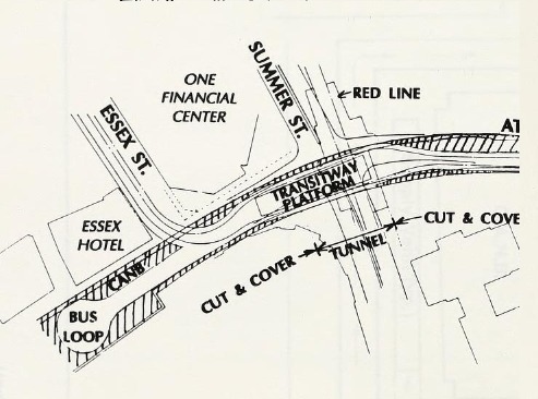
Just to be clear, the route along the Pike does not get you back to the busway at Chinatown Park (to connect to the Seaport) without going through part of the urban core.

Just because it is Chinatown doesn't mean you can just blast you way through the streets.
 
Just to be clear, the route along the Pike does not get you back to the busway at Chinatown Park (to connect to the Seaport) without going through part of the urban core.

Just because it is Chinatown doesn't mean you can just blast you way through the streets.

Depending on the route (which depends on the location of the SL loop) it's considerably less than going down Essex. A fair portion of that area in question was bombed out by urban renewal. It's much easier to tunnel in that than many other places in the city.
 
Depending on the route (which depends on the location of the SL loop) it's considerably less than going down Essex. A fair portion of that area in question was bombed out by urban renewal. It's much easier to tunnel in that than many other places in the city.

Yeah, both Surface Road and Atlantic Ave (the most probable routings from Tufts/South Bay) are wide, have known sub-surface conditions, and were already dug up for 93. It's not like a new tunnel would go down Lincoln or South Street.

I'm also pretty sure the bus loop is by the Bus Terminal along Atlantic Ave, so there's that.
15380609213_afe8518f99_o.jpg

Hummm, I think that the O'Neil Tunnel is already under both of those surface streets? Isn't that kind of in the way?

Per F-Line the bus loop is more over by Chinatown Park, off the Surface Artery.

And you still have to get from the Pike up to Kneeland Street as well. You cannot just follow the Pike wall to the O'Neil Tunnel wall, there is a rather large development in the way now (One Greenway) that is tight against the wall. The only large street is Harrison, and that takes you through the heart of the Tufts Medical Campus and Chinatown (and still does not get you to the busway loop).

I use F-Line's placement as well, but since I haven't seen the documents he bases it on, we're left with competing blueprints.

Even with One Greenway, Hudson is likely the best route. Certainly easier to deal with than Essex.
 
Just for clarity...I was just talking about digging shallow under the grass on the Common. Tying into Tremont and Boylston Streets would be no small matter, of course....but overall this would mean working with a lot more elbow room and a lot fewer utilities (unmapped or otherwise) than would be the case on Essex St.

The sane way to do the Essex Street alignment is to go deep to avoid the utilities. Expensive, but probably worth it. The topography is in your favor, as Essex rises from the Surface Artery up to a peak at Washington and Tremont(now Boylston Street) and then falls toward the Public Garden. Site a deep station somewhere between Chinatown (Orange) and Boylston (Green) under Boylston Street -- if is too narrow, stagger the station platforms (like they did in the old days, both Boylston and Chinatown are staggered platform stations).

You also go under the graves!

If it's deep enough then you wouldn't have to stagger the platform. At least, depending on what's down there.

Looking at that old planning doc for the bus loop it begs the question that if they were planning the Silver Line along side the CAT project then theoretically they would have left room for Phase 3 under Essex St.
 
"Green Line to Transitway" Battle of the Routings! Sunday Sunday Sunday!
 
FWIW, this is what I see as possible EMU/DMU routings with a N-S Link:

  • Riverside - Lowell EMU
  • Riverside - North Shore EMU
  • Riverside - South Station surface DMU/EMU
  • Dedham Corp Center (or Westwood Landing) - Lowell EMU
  • Dedham Corp Center (or Westwood Landing) - North Shore EMU
  • Dedham Corp Center (or Westwood Landing) - South Station surface DMU/EMU
  • Lowell - North Station surface DMU/EMU
  • North Shore - North Station surface DMU/EMU
  • Weston Junction - North Station surface DMU
  • Reading - North Station surface DMU
 
Last edited:
As for OL to Rozzie. Yes. It should be the beginning of a phased replacement of the Needham Line.
1) Extend OL to Roslindale. Partner with a developer to redevelop the station+ parking lots. One MASSIVE below grade parking garage below the current lots+station would replace the spots 1 for 1, plus add parking for residents. Retail where the current lower parking lot is, busway + drop off where the upper parking lot currently is. 2-3 floors of residential above. Added benefit: Station is covered, and free. You could also reconnect South Street with itself, which should help with traffic.
2) Stop-by Stop extend the Green Line to Needham Junction.
3) Close the Needham Line, extend the Orange Line to West Roxbury. Build a new terminal for buses and a park-and-ride behind the Home Depot. With any luck this would capture a lot of the traffic from Dedham-south using the parkways, and could also spawn some TOD where Savers and all that stuff is.

I like this idea - except the MBTA hasn't exactly been known to move very fast even when projects are relatively easy and not as politically risky. the city and BRA are going to have to take the lead on this - like they are going to have to do on the arborway yard project (been what, 15 years now?). They had to strong-arm the MBTA to sell the rozzie substation. now that the substation is finally underway I think efforts in the neighborhood are going to shift to a rozzie OL station.

just FYI - there is currently a plan to run a shuttle bus/rail trail to the needham office park area just off the charles river along the existing ROW - I know the property owners would prefer a green line extension there... but money is an issue.

Sooner or later Amtrak will force the MBTA's hand. Increasing NEC traffic will choke the Needham Line's headways to the point where Needham will be able to claim transit loss. The replacement needs to happen eventually, or else the T will have a very expensive lawsuit on their hands that they will lose.
 
Sooner or later Amtrak will force the MBTA's hand. Increasing NEC traffic will choke the Needham Line's headways to the point where Needham will be able to claim transit loss. The replacement needs to happen eventually, or else the T will have a very expensive lawsuit on their hands that they will lose.

what's the timeframe for this? my digging leads me to believe it'll be another 20 years before we will see any movement - and it has to be tied to south station expansion...
 
Yeah, I'm not in favor of waiting around for Amtrak to force the issue. Plus, if we don't advocate enough for OL, I could easily see us ending up with a Needham GLX, but only more buses as the "solution" for Roslindale and West Roxbury. We need to make the argument now that there is a need for OLX, even if it only ends up happening due to Amtrak and SSX.
 
what's the timeframe for this? my digging leads me to believe it'll be another 20 years before we will see any movement - and it has to be tied to south station expansion...

The time frame is dependent on when South Station expands. That could be in five years or twenty. That will kill off the Needham on its own. If the Link gets done in the next decade, forget about Needham CR. The T and the town knows it's going to happen eventually. The issue is whether it's something that can be worked out proactively, or whether it will be addressed only when the state is up against a lawsuit. Obviously, knowing how this state operates, the status quo is to wait until it's too late and then do something. What needs to happen in order to get this done faster is community education, community outreach, and political activism (like STEP in Somerville).

Yeah, I'm not in favor of waiting around for Amtrak to force the issue. Plus, if we don't advocate enough for OL, I could easily see us ending up with a Needham GLX, but only more buses as the "solution" for Roslindale and West Roxbury. We need to make the argument now that there is a need for OLX, even if it only ends up happening due to Amtrak and SSX.

If Needham gets GLX but Rozzie and WRox lose CR with no OLX they can sue for transit loss, and they'll probably win. But you're right, the T could try to argue that a Silver Line style service would effectively replace the inner Needham Line. Better to not risk that and get the communities thinking about this sooner than later.

Needham would win a transit-loss lawsuit hands down. WRox and Roz probably would, but there's more potential for bustitution schemes succeeding there.
 

Back
Top