Providence, RI I Public Spaces

nicanbot

Active Member
Joined
Jun 18, 2019
Messages
154
Reaction score
204
Not sure if a "public spaces" thread would be better to host the KP makeover and projects like this, but in any event wanted to put this project out there...

Recently released proposals would transform Crook Point Bridge into pedestrian pathway, park. RIDOC put it on the docket to demolish and there was some "backlash" so the city issued a call for proposals to repurpose it using the 6 million demolition cost. I think some of these are pretty neat. Would be great to be able to walk across.


Here is some more detail on each: City of Providence Crook Point Bascule Bridge - City of Providence (providenceri.gov)
 
Last edited:
Not sure if a "public spaces" thread would be better to host the KP makeover and projects like this, but in any event wanted to put this project out there...

Recently released proposals would transform Crook Point Bridge into pedestrian pathway, park. RIDOC put it on the docket to demolish and there was some "backlash" so the city issued a call for proposals to repurpose it using the 6 million demolition cost. I think some of these are pretty neat. Would be great to be able to walk across.


Here is some more detail on each: City of Providence Crook Point Bascule Bridge - City of Providence (providenceri.gov)
I love the willingness to explore similarly priced alternatives to demolition.
 
I love the willingness to explore similarly priced alternatives to demolition.

Assuming this comes to fruition this will be utterly fantastic for Providence's core downtown neighborhoods and another jewel to go alongside the Waterfire amphitheater, the reclaimed greenspace from the I-195 realignment, the new pedestrian bridge spanning the Providence River, and India Point park.

As it is, this will be exactly a half-mile walk from India Point park, so its connectivity to the core downtown greenspaces will be superb!
 
Bridge on fire last night, future uncertain:

WPRI article with video

Boston Globe article:
Lisbeth Pettengill, a spokeswoman for the state DOT, said the engineers would determine if the bridge — stuck in the upright position for decades — is structurally sound. If it is, the DOT will continue with a transfer of ownership of the bridge to the city, which has proposed redesigning it. If it’s not, the state will move ahead with plans to tear it down.
 
I changed the title of this thread from Crook Point Bridge to general public spaces. We should be (I hope so anyway) getting more news on the KP / Waterplace Park plan. Apparently Arup released "final" plans but I don't see on their website - only here: Providence, Rhode Island, and Arup reveal final design for Unified Vision public space project (archpaper.com). It could have been from the public meeting last week though I suppose. Looks like the "mister" is staying...... Will be great to better connect with KP and the planned food hall will complement it all. I stay out of the bus hub argument.....


Also no real damage to crook point bridge.
 
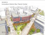
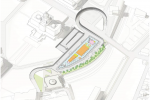
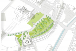
I don't think this was shared yet... Here's the latest on the RIPTA bus hub debacle from RIDOT and some pretty new pictures of what could be a new, central hub on three parking lots in the Jewelry District: RIDOT Multi Hub Alternative Sept 2021 Innovation-District-Bus-Transit-Center_Presentation_2021-update.pdf - Google Drive The Jewelry District Association is onboard. The various advocacy groups against the plan for a series of hubs are still tossing support to improving service at Kennedy Plaza, but voice that this proposal is an improvement and they would support it providing a number of criteria are met - mainly that they are involved in the process moving forward.
 

Attachments

  • Capture2.JPG
    Capture2.JPG
    158.9 KB · Views: 165

Attachments

  • Screen Shot 2021-09-18 at 6.03.45 PM.png
    Screen Shot 2021-09-18 at 6.03.45 PM.png
    1.7 MB · Views: 132
  • Screen Shot 2021-09-18 at 6.03.52 PM.png
    Screen Shot 2021-09-18 at 6.03.52 PM.png
    2 MB · Views: 119
If I remember correctly, the intermodal transportation station by the train station would have required Gaspee Street being slightly moved taking land away from the green park space of the Statehouse. I think that may have been a non starter for many.
 
Personally, I think its a shame that nothing came out of Marsella Development's proposal for an Intermodal Transportation Center at Providence Station. Creating an underground bus terminal at the station better responds to the increasingly likely prospect of a major high speed rail project and would incentivize the development of parcels 3W, 3E 4W, and 4E (which, despite their proximity to Downcity, have sat as surface parking for 30+ years).
Totally agree!

Realigning the street to accommodate this, as well, I believe would more mirror the State House lawn to the west and is in keeping with the original plan. Is that not right? Hilarious to hear politicians bitch about this after allowing so much lawn turned into asphalt parking. Fugly….
 
The Innovation District bus hub proposal checks a lot of "good urbanism" boxes for redeveloping a parking crater into a mixed-use transit facility and could be successful in breathing pedestrian life into an area that currently feels sort of empty. Despite this, a couple parts of the proposal that seem amiss to me.

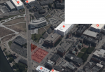
The most obvious is that a not insignificant portion of the structure seems devoted to parking. There are 6 parking garages and countless surface lots within 400 meters of the site. Between the South Street Landing garage, the Johnson and Wales Garage, and the Garrahy Courthouse garage, more than 1500 spaces have been added in the last 10 years. Even if we assume many of these lots are owned by private businesses and universities and reserved for their customers/faculty and assume (or just hope) that surrounding surface lots will be redeveloped, the parking aspect of the project undermines the value and long term viability of the riverfront. The $610 million and $22 million spent on relocating I-195 constructing a new pedestrian bridge were premised on the transformation of Providence's riverfront from Downtown's polluted, industrial periphery to its coveted, scenic, and pedestrian-oriented edge. If Providence wants to attract pedestrian life, startups, and corporate headquarters, it should strictly limit the construction of any new parking infrastructure in view of the river.
 

Attachments

  • adjacent garages.png
    adjacent garages.png
    6.4 MB · Views: 168
  • before.png
    before.png
    5.9 MB · Views: 176
Looking at the second photo you shared, lil, but, sorry, off topic from your comment. I’d love for Brown to in some way recreate the stacks atop South Street Landing. Totally epic!!! I think Providence at large needs to lean more into some sort of steam punk vibe; especially Valley.
 
Looking at the second photo you shared, lil, but, sorry, off topic from your comment. I’d love for Brown to in some way recreate the stacks atop South Street Landing. Totally epic!!! I think Providence at large needs to lean more into some sort of steam punk vibe; especially Valley.


That 2nd photo was taken from 1960-1966 as that is when the Hurricane Barrier was under construction (see just beyond the Point Street Bridge). The area was very industrialized back then. It was not just the South Street Power Station. Look at the shore in EP dotted with oil tanks. I like the area much better today with less heavy industry, more parks, less surface lots, and Rte 195 further south outside the barrier.
 
That 2nd photo was taken from 1960-1966 as that is when the Hurricane Barrier was under construction (see just beyond the Point Street Bridge). The area was very industrialized back then. It was not just the South Street Power Station. Look at the shore in EP dotted with oil tanks. I like the area much better today with less heavy industry, more parks, less surface lots, and Rte 195 further south outside the barrier.
Ah - cool I hadn't noticed. Totally agree it's 1,000 times nicer. The stacks or whatever they are called are cool though! :)
 

Back
Top