czsz
Senior Member
- Joined
- Jan 12, 2007
- Messages
- 6,043
- Reaction score
- 5
I didn't know where else on the forum to put this. Also, wow.
EDIT: Found the images that accompanied the story here:
http://www.bostonglobe.com/ideas/20...ghborhood/iQT5PsdwW6Jo0xX1WuH3XN/picture.html


Holy Brutalpolis!
EDIT: Found the images that accompanied the story here:
http://www.bostonglobe.com/ideas/20...ghborhood/iQT5PsdwW6Jo0xX1WuH3XN/picture.html
Holy Brutalpolis!
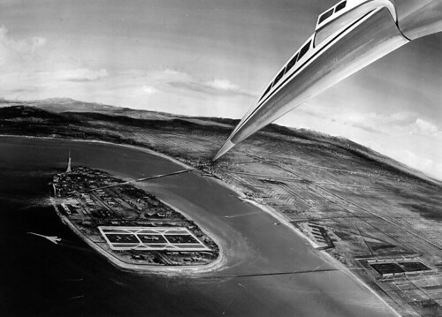
Boston’s lost island neighborhood
(Ideas Section, Boston Globe)
The plan was breathtaking in its ambition: to build a whole new chunk of Boston, a boldly modern new section of the city stretching out into the harbor.
A cross-shaped grid of floating platforms would carry hundreds of acres of soaring block-like buildings and public plazas. The site, stretching from Dorchester’s Columbia Point out to one of the harbor islands, would first serve as a site for the 1976 World Expo, attracting visitors from around the world. Then it would become home to a brand-new neighborhood with housing for tens of thousands, public space designed to be a modern version of Boston Common, and a new subway line.
It was perhaps the most dramatic reimagining of Boston’s landscape in the past half-century. It never happened, of course: The plan fell victim to local politics, and the very idea of a 1976 World Expo disintegrated as the country became caught up in the political and economic uncertainty of the era.
But now this all-but-forgotten plan has resurfaced at the center of a conversation about whether it’s time for Boston to reclaim that sense of vision. The World Expo site was the heart of the inaugural exhibit at the Boston Society of Architects’ new public space near the waterfront. The exhibit’s curators—a group of young architects who also curate the pinkcomma gallery in the South End—and a handful of other thinkers citywide are taking a fresh look at the big planning era of the 1950s and ’60s, an age when Boston still dared to dream big and offer sweeping visions of what the city’s future might be.
Today that era of big planning is known chiefly for the damage it did, the high-handed urban renewal programs that scarred Boston with the memories of demolished neighborhoods and soulless rebuilding. The city and its residents have spent decades understandably wary of such ideas. But these critics point out that the city’s 40-year turn away from that kind of broad vision has also cost us opportunities in developing Boston’s neighborhoods. At a time when Boston seems hamstrung by a piecemeal planning process that leaves the city vulnerable to the whims and fortunes of individual building developers, it’s worth asking if the city needs a different approach to shape its future. And that question has many people reexamining the expo plan—a bold and optimistic souvenir of a time when Boston wasn’t afraid to look ahead.
***
It might seem surprising that something as dramatic as a floating neighborhood would ever be proposed in Boston, but the city had a long history of building outward to the water. Huge swaths of Boston—the Seaport, the South End, the Back Bay, and much of Dor*ches*ter—are land reclaimed from the ocean and from tidal flats.
In the late 1960s, planners started asking: Why stop there? The catalyst for the idea was a planned Bicentennial Exposition, a federally funded celebration of the nation’s 200th birthday that Boston hoped to compete to host. At stake for the winning city was a huge pot of money from the federal government—more than $1 billion.
Gilbert H. Hood Jr., president of H. P. Hood & Sons, had launched a group in 1963 to advocate for Boston as the national site for the exhibition, and the group ramped up its efforts after seeing the success of Montreal’s World Expo in 1967. Its members commissioned a graphic symbol by designers Herman and Lees Associates, and chose a theme: “The Interdependence of Man.” They initially wanted to build the site on landfill in the harbor. At that point, the Boston Redevelopment Authority created a group in 1968 to lead the design.
At the time, Jan Wampler was an idealistic architect just shy of 30. He had worked for the BRA for a few years before spending two years in Puerto Rico. He returned to the city in need of a job, and he inquired at his former employer. “At the time, they wanted someone to draw a perspective of the proposed world’s fair, based on Montreal,” says Wampler, who is now an architecture professor at MIT. Instead, he asked for two weeks to come up with something different. “I wanted to see the fair as a way to solve problems, urban problems at the time.”
He envisioned the fair as a living urban laboratory, in which countries and corporations would be invited to showcase research on ways to improve the city. He imagined that Japan might build a forward-thinking train system, General Motors could exhibit an electric car, and the construction industry could build innovative housing that would remain as a legacy for the city.
Although his plan went against a trend toward more overt commercialism at such expos, his bosses agreed. Wampler was put in charge of a small team of young architects under Charles Hilgenhurst, urban design director of the BRA.
By the 1960s, people had become worried about the ecological effects of massive landfills like the ones that built the Seaport District and other Boston neighborhoods, so Wampler offered a different approach: building on platforms tethered to the seafloor. The design was a geometric, Modernist vision, a grid extending out into the water all the way to Thompson Island. The grid was a framework for various modular buildings, which would fill in the grid’s squares. It was meant to be a flexible system, the contents of which could change over time.
The new section of the city would connect Columbia Point to Thompson Island. There would be a subway line from South Station, minitransit around the man-made island, space for a commuter campus of the University of Massachusetts—the current UMass Boston campus was still years away—and a climate-controlled geodesic dome for public use on Thompson Island. The total site including the island would span 690 acres, comparable to the size of Beacon Hill, with 351 acres of open space, including parks, exhibition areas, and museums, plus visitor housing that would later be transformed into housing for low-, middle-, and high-income residents—a new community of 45,000.
Although private businesspeople like Hood were instrumental in pushing for the project, seeing through a project of such scale required a powerful central planning authority, and Boston had one at the time. The Boston Redevelopment Authority had been created in the late 1950s because the city needed a powerful agency to get the federal dollars it sought for renewal projects. But it truly gained force in the 1960s, after Mayor John F. Collins brought in city planner Edward J. Logue as director. Logue pushed for an agency that combined planning and redevelopment under one roof, marrying a vision for the city’s future with the power to make it happen. “He felt that only that kind of concentrated authority would be able to turn around Boston, with its decades of decline and entrenched politics,” says Lizabeth Cohen, a historian at Harvard and dean of the Radcliffe Institute.
By then, Boston’s midcentury renewal efforts were well underway, a series of drastic projects designed to revive an ailing city whose upper- and middle-class residents had been fleeing to suburbs. “The city was in really terrible shape by the late 1950s,” Cohen says. In 1954, the Massachusetts Department of Public Works constructed the Central Artery that sliced through downtown. In the late 1950s, the newly formed BRA bulldozed the brick tenements and shops of Boston’s West End to create the privately developed Charles River Park high-rise apartments. When Logue took charge, he wanted to differentiate his plans from the controversial West End project underway; he instead oversaw the razing of Scollay Square, the city’s red-light district, to be replaced with a “Government Center” that would help revive downtown using the power and dollars of city, state, and federal government.
Despite the misgivings stirred by those previous projects, Bostonians apparently still had a taste for ambitious ideas. The expo proposal enjoyed wide support through the city—a 1969 poll found that 77 percent of Boston residents supported it. But it also attracted powerful opponents. At the forefront of the opposition was Louise Day Hicks, a South Boston politician who had just lost the mayoral race to Kevin White, and is most known for opposing desegregation of Boston’s public schools. In May of 1969, she led a public meeting to protest the move.
The opposition came to focus on the argument that the construction—though designed to have minimal impact on the environment—would impede tidal flows in a harbor that had serious pollution issues at the time. Looking back, Michael Kubo, a codirector of pinkcomma gallery who led the research on the expo project for the BSA exhibit, believes that the project was also caught up in the racial politics of the time, since it would have included affordable housing on the site, and a T line that would connect mostly white South Boston to the nonwhite neighborhoods of Dorchester.
That September, Boston’s City Council, whose power bases lay in the city’s neighborhoods, voted to oppose the plan. The mayor’s office still backed it, and a delegation led by White and Governor Francis W. Sargent traveled to Washington, D.C., to present the proposal formally to the federal commission. But so did an anti-expo contingent, including Hicks, then-State Senator Joe Moakley, and Representative Michael Flaherty of South Boston, to make a counter-presentation and discourage the government from picking Boston. With its host city so publicly divided, the expo proposal was effectively derailed.
In many ways, the demise of the expo plan heralded the end of an era. By the late 1960s, a burgeoning preservation movement had begun to promote the idea that Boston should protect its heritage rather than replace old with new. Neighborhoods were discovering that they could shape planning and even block plans they didn’t like.In the early 1970s, for instance, grass-roots pressure helped to kill a planned Southwest Expressway connecting I-95 to South Boston, using the site instead for a new route for the Orange Line and the Southwest Corridor parks and bike path. Public funding for city projects began to dry up, and the idea that the BRA could make big decisions by fiat was gone.
I n many ways, those changes were undoubtedly positive. However promising they sounded at the time, Government Center and the demolished West End are now almost universally seen as miscalculations that damaged Boston’s historic heart; such moves are now nearly impossible to imagine. Planning takes place through a process of negotiation between developers, community members, and Mayor Menino’s City Hall. The BRA today still develops plans and exerts control over Boston development, but it serves more as gatekeeper. Its planning director, Kairos Shen, argues that this negotiation process results in better design. “It’s not just about the boldness of the vision; there’s also this issue of the quality and appropriateness of the vision,” he says. “We have a very different set of values now.”
But when some historians and architects look at those values, they also see a city that has closed itself off to the possibility of big plans for the long-term future—the kind of vision that the Expo plan represented.
“I think that period offered a leadership that we’re lacking now,” says Mark Pasnik, a principal at over,under and one of the exhibit’s organizers. He acknowledges that today’s small-bore, case-by-case approach has “some healthy sides to it,” but worries that without a larger picture of where the city is going it’s not possible to make decisions for the city that might benefit the collective good rather than simply reflecting the interests of affected neighborhoods.
“Every city needs to have bold strokes in the city as well as individual strokes—I think they’re harder to do now,” says Wampler. “I suspect Frederic Olmstead would have a terrible time designing the Emerald Necklace now,” he adds.
Boston is an overwhelmingly healthier city than it was a half a century ago. But it still faces challenges and choices: how to deal with continued gentrification of the city center, how to develop its waterfront more fully, how to balance density with open space, how a coastal city should confront long-term environmental and climate risks. Although the BRA has plans for sections of the city, the last master plan for Boston development is one the agency produced in 1965, and revised in 1975. Shen says such comprehensive plans are too nonspecific and cumbersome, but Pasnik argues that they can be important in getting beyond “medium scale” strategies and thinking of the city as a whole.
Is it possible to regain the bold sense of Boston’s future without the disasters of the previous era? “We want communities to have a say, and we want developers to be rewarded,” says Pasnik. “I think we need to tip the balance back.”
Some thinkers go even further, and say it’s time to acknowledge that effective planning means thinking beyond the city limits. George Thrush, head of Northeastern University’s architecture school, has been pushing for a project called the Urban Ring, which would create public spaces that link together long-disconnected areas in Boston, Brook*line, Cambridge, Somerville, Chel*sea, and Everett. But such a plan would require an authority that can cross town lines. “The notion of regional identity is something that Boston as a modern economic powerhouse has to deal with,” he says. “What we really need is a regional development agency.”
The recent Boston Society of Architects exhibition was intended to start the conversation, and Pasnik admits it’s one largely fueled by academic thinkers now. But that’s part of the process: We won’t see the future differently until we can come to terms with the city’s past and reexamine it with new eyes.
Keith Morgan, a historian of architecture at Boston University, says that first step is already happening. Younger historians and architects are “not ac*cepting the standard text that urban re*newal was bad, evil, and everything that happened during that period was terrible,” he says. “That’s all ridiculous, and entirely too easy a dismissal of a time when Boston completely remade itself.”
Last edited: