- Joined
- May 25, 2006
- Messages
- 7,034
- Reaction score
- 1,875
With all this talk of a new set of towers to replace the Basketball City garage I got to thinking about how to better integrate the West End back into the city. I'm sure there are many out there who would love to see the modern towers leveled and the old West End rebuilt but that isn't in the realm of reality (besides, it will never be the same so let's stop living in the past).
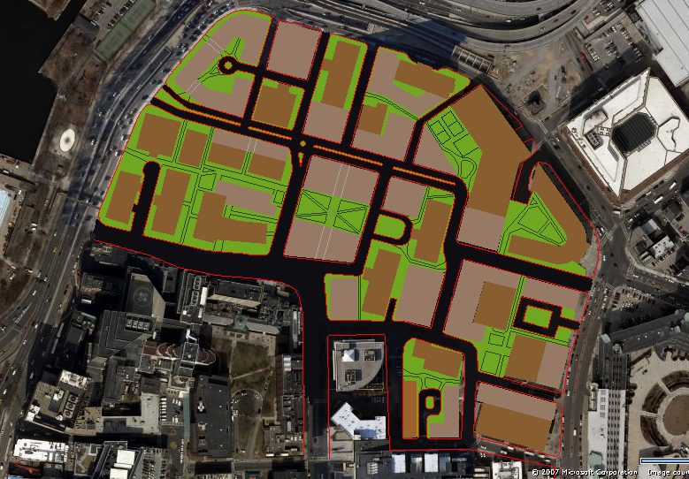
Where the new proposals for the West End fall short, in my opinion, are the lack of connectivity. Contextually all new buildings in the West End still stick to the legacy of the "Tower in the Park". Until the city does anything to alter this mindset we will still have towers in the park.
The obvious solution is the build new streets. We could recreate the old street layout of the former West End but why move backwards? If land prices are so high that it only makes sense to have apartment buildings then a simpler grid makes more sense.

The modernist planning idea for traffic management says that it is best to have all side streets feed into large arteries. This has the desired effect of keeping high speed traffic off residential streets but the unfortunate effect of deadening neighborhoods in some areas while concentrating traffic and pollution in other areas. The West End was planned in this way with major traffic arteries along Charles, Blossom, Staniford, and Lomansey while smaller streets were only left if they went directly into parking garages.
What my proposal lays out is a new grid over the existing West End. To save money the grid is, for the most part, worked around existing buildings (only a couple buildings would need to be demolished). Instead of trying to totally rebuild the West End it would be much better to layout infrastructure which compliments the exiting "urban fabric" so that the buildings can graft themselves back into the city.
The new grid would better distribute traffic through the West End by giving drivers more options while at the same time keeping thru traffic along the existing arteries. The arteries, meanwhile, could be redesigned to handle less traffic and be more pedestrian/bike friendly. The new local streets would break up the street to the point where the arteries no longer feel like highways.
The new grid would also allow for a variety of new building sizes to be built. Small park squares would be left but instead of undefined suburban greenspace the new squares would help define the neighborhood.
Along the western most part of the West End, along Charles St, would be built a two-level road in the vein of Wacker Dr in Chicago (Yellow Line). All thru-traffic would use the lower level while the upper level would be only local traffic. The buildings along Charles St would be slowly rebuilt to have their main entrances along the upper level while the lower levels would be used for loading areas (another way to keep truck traffic down). The buildings along Charles St would be allowed to be built much higher because of this (because of their location shadows would not affect the residential areas).
****
This is a work in progress. I was just really bored at work. I've seen many other similar ideas and figured we needed a place for them all.