You are using an out of date browser. It may not display this or other websites correctly.
You should upgrade or use an alternative browser.
You should upgrade or use an alternative browser.
Rose Kennedy Greenway
- Thread starter callahan
- Start date

palindrome
Senior Member
- Joined
- Jun 11, 2006
- Messages
- 2,288
- Reaction score
- 140
Thats a clear cell cam!
statler
Senior Member
- Joined
- May 25, 2006
- Messages
- 7,944
- Reaction score
- 562
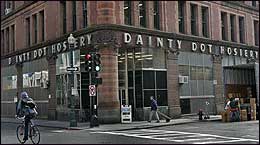
LinkThe Globe said:Developer buys historic Hub textile building for $9m, plans residences
By Thomas C. Palmer Jr., Globe Staff | November 7, 2006
The real estate along the edge of the old Central Artery in downtown Boston is beginning to take on a new life, the latest development being the proposed redevelopment of a once prominent textile building.
Swampscott businessman Ori Ron, who redeveloped 50 residential units in the nearby Leather District, has purchased the old Dainty Dot Hosiery property on Kingston Street near Chinatown for $9 million. A large portion of the building was lopped off in the mid-1950s to make way for the artery, but a six-story, 53,000-square-foot structure remains.
Ron has tentative plans for residential housing on the site but has not released more details. Under current zoning Ron can build a 100-foot tall building on Kingston Street, but would need city approval -- and likely neighborhood support -- if he wanted to build something taller.
Ron has hired Elkus/Manfredi Architects of Boston, which designed the stylized InterContinental Boston Hotel and Residences farther along the new Rose Fitzgerald Kennedy Greenway, on Atlantic Avenue.
The Greenway has already triggered a number of property improvements and real estate developments in the area. Upscale condominiums are opening nearby on State and Broad streets, Fidelity Investments is putting in a park near the New England Aquarium, and the Federal Reserve Bank of Boston recently completed a large public plaza at its front door in Dewey Square.
Meanwhile, the owners of several office buildings that look out onto the Greenway, such as the International Place towers, are considering changes to their street-level spaces, possibly by adding new restaurants.
The Dainty Dot building, with Art Deco lettering, overlooks the site of a new Chinatown park. The 14,400-square-foot site includes two triangle-shaped open spaces.
The building was built in 1889 after the Boston fire of 1872 destroyed a residential neighborhood. It is on the National Register of Historic Places because of its location in a once-significant textile district, and the Boston Landmarks Commission is considering a petition to declare it a landmark, which would protect the exterior from demolition or major alteration.
Ron "really feels an obligation to do something special on the site that includes a nod to the future and to the past," said Michael K. Vaughan, the president of Nauset Strategies Inc., a real estate consultant hired by the developer. That means keeping at least a portion of the Dainty Dot building intact.
"It's a very important site because of where it is on the Greenway," said Vaughan. He said Ron hopes to file plans with the city before the end of the year.
Ron's company, Hudson Group North America Real Estate Trust, and partners are scheduling meetings with Chinatown community groups.
"It's a beautiful building," said Stephanie Fan, a representative of the Chinatown community on the Mayor's Central Artery Completion Task Force. "I'd like to see the open space around it turned in some way compatible with the park."
Thomas C. Palmer Jr. can be reached at tpalmer@globe.com.
vanshnookenraggen said:ablarc posted a long thread way back in the Skyscraper guy's forums which outlined the route from the SB Waterfront, along the Greenway to the Navy Yard which I still think is the ideal route. Any way you could repost that?
Couldn't find it right away. Sorry.
BOSTON'S NEW AQUA LINE
Sometimes ?often in science and always in art?one doesn?t know what the problems were till after they have been solved. ?Gregory Bateson
Back when downtown Boston still had a serious seaport, there was a waterfront transit line. It was called the Atlantic Avenue El(evated), and like the seaport it served, it was dirty and gritty. It fell to the wreckers in the forties, but its DNA survived as a gleam in the planners? eyes, and it was reborn as the Fitzgerald Elevated Highway, aka Central Artery.

The Atlantic Avenue El

Expressway Coming Down
Now the elevated expressway in turn is headed for the dustbin of history. To placate the NIMBYs it will be replaced largely by a linear park. Linear is more usually the shape of transportation; and the need for transportation along Boston?s waterfront still rages, especially as that waterfront morphs into a theme park with residents.

Linear is also the trajectory of tourists. They love to do the Freedom Trail with its jaunty red line, though past Copp?s Hill it becomes a chore best left for another day. That day never really comes; there are better things to do than visit Charlestown if there?s going to be so much effort involved; it?s a long walk and pretty grim; and you can?t hop a ferry at Copp?s Hill.

It?s also a long way from the Seaport District to the Navy Yard, a natural day?s itinerary for tourists. Some of it is pretty uneventful, but it could be interesting if you could sort of glide by some of it at about the speed of a horse. At that pace, this could be Boston?s Waterfront Trail, also defined by a line: the AquaLine.

* * * * *
San Francisco city limits: 46.4 sq.mi.; 776,733 population; density: 16,740/sq.mi.
Boston city limits: 47.2 sq.mi.; 589,141 population; density: 12,482/sq.mi.
Boston and San Francisco are like peas in a pod. They are centers of similar-sized metropolitan areas containing numerous satellite cities. In each, those satellite cities contain a pair of world-class universities and renowned high-tech industry. Each boasts a full complement of professional athletic teams.

Their cores occupy densely built-up peninsulas on large, protected bays, with obsolete seaports converting to recreational use. They have about the same number of people, and those people are packed into roughly the same area. They are both known for their beauty and walkability, with distinguished architecture and well-known monuments. They contain charming neighborhoods filled with funky shops and defined sometimes by architecture, sometimes by wealth or ethnicity or academia or sexual preference. And they both have a thriving tourist industry.
One city is much older, but they both live the same because they grew large before the automobile changed growth patterns. Each is a real city: a place in which substantial numbers of people, when they leave their front doors, do not get into their cars; and a place where most buildings touch. Consequently, each city has much-used public transport. In both cities, that transport needs improvement.
Rail-based transportation in each city consists of commuter rail, heavy rail, and surface light rail that then tunnels into each city?s hub. But San Francisco has even more: not one but two little extras loved and used by residents and tourists alike.
Everyone knows about the cable cars; they not only serve the visitor, they attract him as well. They are listed as the city?s number one tourist attraction.
But the cable cars now have colleagues. Collectively, these colleagues are known as the Muni F-Line, or the Historic Streetcar Line or the Market Street Railway. They are old streetcars salvaged from Newark and St. Louis and Milan, Melbourne and Moscow, New Orleans, even Hiroshima, Lisbon, Blackpool and (yes!) San Francisco. Most of the Americans are PCCs (like the ones that go to Mattapan) and are gaily painted in the liveries of various cities that used to run them, including Boston.

Boston Colors In San Francisco
The Market Street Historic Streetcar or ?F? Line runs on the surface of San Francisco?s main drag, broad Market Street, where streetcars once congregated so densely on four (count ?em) parallel tracks that they made a kind of Chinese wall between the sidewalks of this thoroughfare. The streetcars were shifted underground (like the Green Line under Boylston Street) when the tunnel was built for BART, the heavy rail line.


Melbourne
So here, at various levels all on one alignment, are: 1. all San Francisco?s light rail subway routes; 2. the heavy-rail subway (like the Red Line) to Berkeley and beyond; 3. miscellaneous electric trolleybuses; and most recently, the restored surface streetcars of the Market Street Historic Streetcar Line! What folly, you say, what duplication!

The ones on the right run under Market Street; the others on top.
The F-Line then turns at the Ferry Building, where Market Street meets waterfront, and follows the graceful, tree-lined trajectory of the refurbished bayside Embarcadero, once host to the much-hated and now-demolished (sounding familiar?) elevated freeway. Rumbling along Embarcadero, the F-Line links all the waterfront tourist hotspots, until it meets up with the cable cars near Fisherman?s Wharf.

Milan and PCC

Embarcadero Waterfront with San Francisco's Own

Tourists.
A jolly ride, soon to be extended. This line does not cannibalize the duplicate underground lines for riders. Where tourists formerly were deterred from going, or where they slogged wearily alongside parking lots, or drove, they now ride the F-Line, cheerfully rubbernecking as they go. They exploit the frequent headway of this line, hopping off and on, as something new to attract them heaves into view, while wafting by the sleaze and dull stuff at exactly the right speed and distance. In fact, the line is so entertaining that they ride it all the way to its terminus at the Castro, where the gay guys live. Something they never would have dreamed of before. And the gay guys? Why, now they ride it too.
So here is a line that made a market for itself, where none existed before. Just by being so darn entertaining.
By now it must be dawning that Boston?s Greenway shares features with Market Street and the Embarcadero, including a broad right-of-way, and adjacency to a waterfront, a neighborhood and a financial district. Similar conditions can call for similar responses, even in different cities.
All the wet rags say: WE CAN?T DO THAT IN BOSTON!!
1. WE CAN?T DO THAT IN BOSTON because it?s already been done in San Francisco, and we don?t want to seem like copycats. And they had already built skyscrapers in Chicago when we erected the Ames Building and the Custom House Tower. And when we built the first U.S. subway, they already had subways in London and, uh, Budapest. When we built the Fitzgerald Expressway, they already had an elevated highway in New York. And brick row houses: did we get those from London? Cable-stayed bridges: did someone see one in Cologne? The termites have been building cities for millions of years. Now it?s time to be original. What shall we build?
2. WE CAN?T DO THAT IN BOSTON because San Francisco already has first dibs on all the old streetcars they?re getting rid of in Newark. Ok, we anticipated this one: our source is Portugal; different kind of streetcar there (cute and tiny). Or Hong Kong?: now that?s different. Have you seen the streetcars in Hong Kong? Hey, how about those old clunkers in Mattapan: wouldn?t the folks there like something a little smoother to ride? with chimes when the doors close?


A San Francisco Original...

...and a Boston Original. Do any survive?


![Dscn0574[1].jpg](http://bellsouthpwp.net/a/b/ablarc/2003-06-27/Dscn0574[1].jpg)
FURTHERMORE:
3. WE CAN?T DO THAT IN BOSTON because we have more important things to spend our money on than such frivolities as this. Important things like world hunger, and genocide relief, and justice for all. Too bad the Feds won?t pay for that with Big Dig Greenway funds. We always pick the wrong government.
4. WE CAN?T DO THAT IN BOSTON because the weather isn?t right for it. It?s always somewhere around room temperature in San Francisco, whereas Boston is cold, baby; and hot in the summer. The AquaLine runs Spring, Summer and Fall, from March 21 through 6 pm December 24. In Winter, the MBTA substitutes what it sees fit; the snow would probably clog the New York and Washington-style underground electricity conduits, even with today?s superior technology. In summer, the windows are open, and it?s a darn sight preferable to walking in the merciless sun.
Regardless of the Greenway?s final design, the AquaLine is a natural because it integrates so unobtrusively into any design.

New Orleans streetcar in median of St. Charles Avenue
It shuttles tourists, conventioneers and lucky Bostonians from the Fleet Pavilion and Fish Pier via Commonwealth Pier and the dismal Courthouse, it clatters across the restored and pedestrianized Northern Avenue Bridge, then glides by Rowe?s Wharf, Harbor Towers and the Aquarium. At Long Wharf and Quincy Market, by selective demolition of view-obstructing buildings, the panorama opens expansively and dramatically to both ocean and city: Quincy Market?s temple front again visible from the water.

Quincy Market From the Sea

Custom House From the Sea, before tower added

Open Quincy Market and Custom House to the Greenway and the sea! Demolish two buildings.


Here the AquaLine bids farewell to the Greenway, and peels off to trace Commercial street round Columbus Park and past the burgeoning North End Waterfront residential district, spreading further high-end commercial and residential development opportunities like pixie dust as it goes.
At last it scoots across the Charlestown Bridge, crosses City Square, passes the depressingly suburban parking lots, office complex and Bunker Hill Pavilion, and the vast expanse of unrelieved asphalt at the USS Constitution (poor Charlestown!). Then, I extravagantly suggest, it should bifurcate.
Branch One ought to rumble serenely down Lincoln Avenue all the way to the end of the Navy Yard, dropping off suits with briefcases as it goes. Branch Two is a modest engineering extravaganza: through a portal, this branch deep-bores directly into Breed?s Hill, coming to rest at a tiny station deep below Monument Square. From here, a 30-person self-service elevator yields access directly to a small pavilion at the base of the Monument.
FINALLY:
5. WE CAN?T DO THAT because we are sensible guys, and we know that we can just run a nice tourist bus on this route at next-to-no infrastructure expense. We can dress it up to look like a trolley. And we can watch everyone not ride it. Then we?ll know, after the sensible trial period, that there was no market there to begin with. Actually, we could short-circuit this entire pointless and predictable exercise by putting its allocated funds to some other use. We could, for example, build an archaeologically exact replica of the first house in Boston (1630) somewhere on the Greenway (wheelchair accessible), and staff it with ladies in bonnets. They could answer questions about basketmaking, and direct people to the toilets.
6. WE CAN?T DO THAT because we already have transportation along much of the AquaLine?s route. It is not competition for the Silver Line, which is serious transportation. Green and Orange Line are also not its rivals; they have no views, and they don?t hug the Waterfront or (really) go to Charlestown.

Blackpool Seaside Open Tram

The AquaLine knows.
I
IMAngry
Guest
Parkland on Greenway
Great post about the Aqua Line.
One thing - you say, "the Greenway will be mostly parkland, thanks to NIMBY's"? How so? What would you have preferred? You can't build high-rises on there, or they'll crush the underground roadway.
Great post about the Aqua Line.
One thing - you say, "the Greenway will be mostly parkland, thanks to NIMBY's"? How so? What would you have preferred? You can't build high-rises on there, or they'll crush the underground roadway.
palindrome
Senior Member
- Joined
- Jun 11, 2006
- Messages
- 2,288
- Reaction score
- 140
Glad their building a park in Boston, while they build office campuses in North Carolina.
tmac9wr
Senior Member
- Joined
- Jun 14, 2006
- Messages
- 1,446
- Reaction score
- 68
Very true....hopefully if the talk about Boston's job market recovering is true we'll see them bring more jobs back into the area.
Looking at those pictures makes me very excited about the building that is supposed to replace that awful parking structure. Downtown is going to be an absolute gem in a few years if the envisioned projects get built. Does anyone know anything more about that proposed tower?
Looking at those pictures makes me very excited about the building that is supposed to replace that awful parking structure. Downtown is going to be an absolute gem in a few years if the envisioned projects get built. Does anyone know anything more about that proposed tower?
bosdevelopment
Active Member
- Joined
- May 26, 2006
- Messages
- 727
- Reaction score
- 2
Looks like Mars in Total Recall.
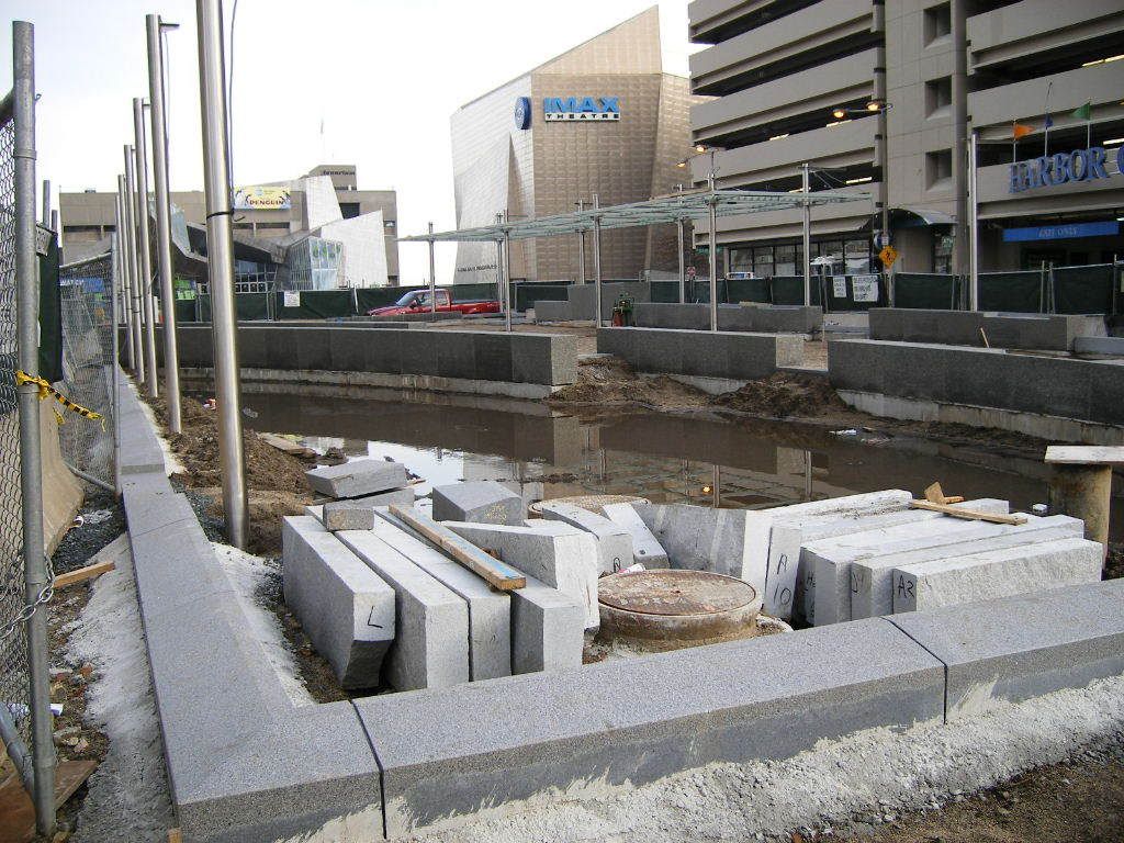
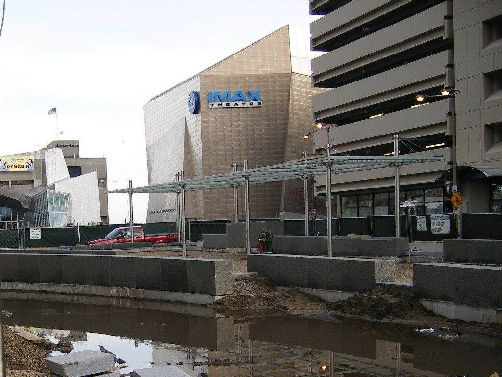
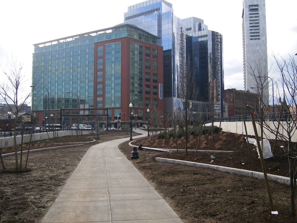
Is this the level of quality we can expect generally?xec said:Temporary (one hopes) park being created on parcel 18...
What shall we do now, Harry? I know, let's put some curves in the granite edging.
Madonna Mia.
atlantaden
Senior Member
- Joined
- May 31, 2006
- Messages
- 2,679
- Reaction score
- 3,344
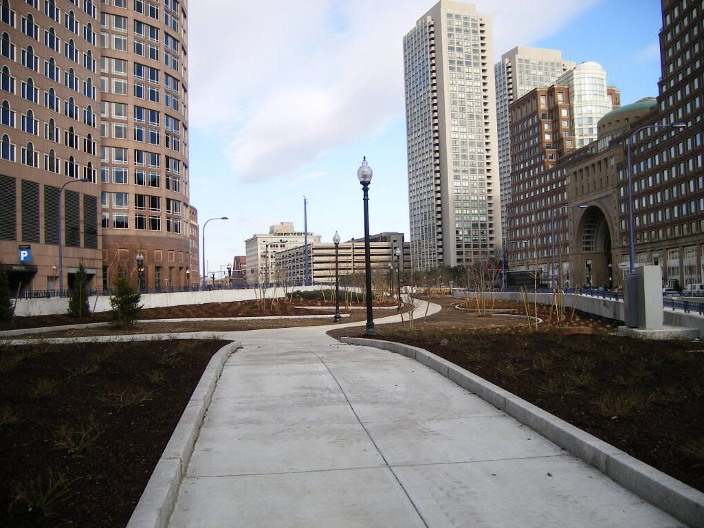
Where are the park benches for all of us "seniors" who like to sit for a while and people watch?
L
lndscpr
Guest
ablarc said:Is this the level of quality we can expect generally?xec said:Temporary (one hopes) park being created on parcel 18...
What shall we do now, Harry? I know, let's put some curves in the granite edging.
Madonna Mia.
i dont think it is so bad. I assume there is grass intended to go next to the edging. What would you do to improve it. It is pretty good for something that is temporary.
Ron Newman
Senior Member
- Joined
- May 30, 2006
- Messages
- 8,395
- Reaction score
- 14
It's a temporary park, it's not finished, and it's winter. What do you expect?