I assume they did the 4th floor in that black and stepped back to make this not look so "large", but because of the grade of the street and this being ground level (no couple steps up to ground floor), it actually looks too short to fit in properly.59-63 Belgrade Avenue (31 units)

You are using an out of date browser. It may not display this or other websites correctly.
You should upgrade or use an alternative browser.
You should upgrade or use an alternative browser.
Roslindale Infill and Small Developments
- Thread starter PaulC
- Start date


SuffolkHeights11
Active Member
- Joined
- Mar 3, 2021
- Messages
- 120
- Reaction score
- 457
It is incredible for me how little the 130+ page “Roslindale Square Small Area Plan” actually includes as far as tangible proposals. The entire “Squares and Streets” initiative has been a master class in talking a lot and saying very little.
Just give me a damn before and after map to show the changes. This doesn’t have to be so hard.
To paraphrase a local sports radio host, I could re-zone Roslindale Square on the back of a napkin in an hour. Keep in mind this is only the plan to rezone, not the actual zoning plan. That involves another round of plans, meetings, workshops, and it goes on and on.
Wealthy urban cities have become very adept at this, a big part is graphic design. Compare municipal documents of today to the stuff you find on archive, it’s so snazzy looking but often all fluff.It is incredible for me how little the 130+ page “Roslindale Square Small Area Plan” actually includes as far as tangible proposals. The entire “Squares and Streets” initiative has been a master class in talking a lot and saying very little.
Just give me a damn before and after map to show the changes. This doesn’t have to be so hard.
I think this is all a step in the right direction, but it’s sad to think that probably there won’t be any major revision to this for many more decades. I do think a few more owners on Washington are likely to build up. But the main thrust of the plan is “ hey let’s rezone the MBTA parking lot“ as if the MBTA is ever, in a million years going to develop it.
Randomgear
Active Member
- Joined
- Jul 7, 2012
- Messages
- 364
- Reaction score
- 46
Squares and Streets will allow the former "bank of America building" to be sold and rebuilt to multiple stories without zoning relief needed, an absolutely huge selling point. And the current Co-Operative Bank is now proposed to be zoned so that they can expand in-place, without having to buy/rent more satellite parking lots. Lots of opportunities elsewhere as well.
The plan also goes far above just zoning with public space initiatives and proposed traffic pattern changes that restore some pavement back to a more public realm.
The plan also goes far above just zoning with public space initiatives and proposed traffic pattern changes that restore some pavement back to a more public realm.
HenryAlan
Senior Member
- Joined
- Dec 15, 2009
- Messages
- 4,473
- Reaction score
- 5,256
The convoluted process is all done to placate the NIMBYs who are distinctly not the majority population in Roslindale. That said, as a visioning process, I think it did a pretty good job and also to some extent gave us ammunition against the NIMBY response, which has been fairly muted.To paraphrase a local sports radio host, I could re-zone Roslindale Square on the back of a napkin in an hour. Keep in mind this is only the plan to rezone, not the actual zoning plan. That involves another round of plans, meetings, workshops, and it goes on and on.
stick n move
Superstar
- Joined
- Oct 14, 2009
- Messages
- 13,480
- Reaction score
- 24,527
stick n move
Superstar
- Joined
- Oct 14, 2009
- Messages
- 13,480
- Reaction score
- 24,527
Eight-unit condo building approved for vacant lot in Roslindale

“The Zoning Board of Appeal yesterday approved plans to build an eight-unit condo building with four parking spaces on a vacant lot at the corner of Washington and Cornell streets in Roslindale.
Jeff Drago, attorney for developer Jon Wardwell, said the building does not need more parking because it is across the street from a bus stop for several lines and within "walking distance" of the Roslindale Village commuter-rail stop. Access to the parking will be through an existing driveway on Cornell Street.
The building will have solar panels installed on the roof, he said…….”
https://www.universalhub.com/2025/eight-unit-condo-building-approved-vacant-lot-roslindale
stick n move
Superstar
- Joined
- Oct 14, 2009
- Messages
- 13,480
- Reaction score
- 24,527
ApprovedNearly 50 Unit Apt. Project Planned in Roslindale
“Plans are under review for a 4-story multifamily on 3 vacant lots at 586-598 Canterbury St. in Roslindale. The building would include 46 apartments, a mix of studios through 3 beds with 32 parking spaces.”

https://www.bldup.com/posts/nearly-50-unit-apt-project-planned-in-roslindale

2025-04-10_BPDA Board_586-598 Canterbury Street.pdf | Powered by Box
 bpda.app.box.com
HenryAlan
Senior Member
- Joined
- Dec 15, 2009
- Messages
- 4,473
- Reaction score
- 5,256
I hate to say this, because I really want to cut down on parking induced car reliance, but for that particular location, I do not think less than one parking spot per unit is viable. It's a mile walk to Forest Hills, or there is the infrequent 14 bus that isn't particularly useful unless your destination is in Roslindale or Roxbury. And that's it. The area is reasonably bikeable, but without a transit option, we can't really expect people to not rely on cars. Between this and other projects near the American Legion-Walk Hill intersection, it might be time for the MBTA to start looking at some sort of Walk Hill bus route. But without that, it is really a very auto-centric location.
hmmm, I see what you are saying. I'm kinda surprised there isn't already a bus that would say connect Mattapan to Forest Hills, but then again, Morton Street, Walk Hill Ave, and Cummins Highway all feel roads that wouldn't justify a bus route along them. Cummins does have a bus along it already though.I hate to say this, because I really want to cut down on parking induced car reliance, but for that particular location, I do not think less than one parking spot per unit is viable. It's a mile walk to Forest Hills, or there is the infrequent 14 bus that isn't particularly useful unless your destination is in Roslindale or Roxbury. And that's it. The area is reasonably bikeable, but without a transit option, we can't really expect people to not rely on cars. Between this and other projects near the American Legion-Walk Hill intersection, it might be time for the MBTA to start looking at some sort of Walk Hill bus route. But without that, it is really a very auto-centric location.
That being said, the 14 may be pretty infrequent, but a very short walk up to Hyde Park Ave via Neponset Street (0.5 miles) is very doable, especially with the 15 minutes headways the T shows for the 32 bus. If the developers have pushed their pro-forma to say that it this development will work with the minimal parking, I applaud them, this is what we should aspire to from a development standpoint.
This is unfortunately a direct consequence of the horrendous lack of central planning for development: the only areas that tend to become available for large scale developments are areas that are large spaces of developable land, and by definition, spaces like this tend to be far from dense neighborhoods and much more likely to be in desolate locations and/or along highways or otherwise areas that are poorly served by transit.I hate to say this, because I really want to cut down on parking induced car reliance, but for that particular location, I do not think less than one parking spot per unit is viable. It's a mile walk to Forest Hills, or there is the infrequent 14 bus that isn't particularly useful unless your destination is in Roslindale or Roxbury. And that's it. The area is reasonably bikeable, but without a transit option, we can't really expect people to not rely on cars. Between this and other projects near the American Legion-Walk Hill intersection, it might be time for the MBTA to start looking at some sort of Walk Hill bus route. But without that, it is really a very auto-centric location.
I really can’t stand watching the filling in of places like this… inevitably they just are marginal developments that feel isolated and cheap. They only are being developed because the space happens to be there. I know it’s idealistic given our unfortunate form of government, but instead of development being governed by the lowest hanging fruit of most available space for the cheapest development and least amount of neighborhood opposition, large developments instead should be planned and located in the areas that would benefit the future residents the most and be along transit and close to jobs.
This is an incredibly shitty walk. Half a mile strolling down Centre St in JP is one thing; half a mile on American Legion, looking at strip malls and surrounded by aggressive drivers, is another. Most people are not going to find this “very doable”. Long, shitty walk, wait for bus on Hyde Park Ave, slog to Forest Hills, then OL to another destination is a long journey that many people do not want to make.hmmm, I see what you are saying. I'm kinda surprised there isn't already a bus that would say connect Mattapan to Forest Hills, but then again, Morton Street, Walk Hill Ave, and Cummins Highway all feel roads that wouldn't justify a bus route along them. Cummins does have a bus along it already though.
That being said, the 14 may be pretty infrequent, but a very short walk up to Hyde Park Ave via Neponset Street (0.5 miles) is very doable, especially with the 15 minutes headways the T shows for the 32 bus. If the developers have pushed their pro-forma to say that it this development will work with the minimal parking, I applaud them, this is what we should aspire to from a development standpoint.
If your final destination is right on the bus route, walking a ways to the stop is one thing. Most people don’t have this situation. Asking a long walk to a bus that then leads on to further connections is not an acceptable option to most people, and I don’t blame them.
Last edited:
HenryAlan
Senior Member
- Joined
- Dec 15, 2009
- Messages
- 4,473
- Reaction score
- 5,256
The closing of the Boston State Hospital opened up a lot of land between Blue Hill Ave and Hyde Park Ave, much of it now being developed, along with many underutilized adjacent parcels like this one. The right approach would have been to set it aside for development with the provision that the developer would first need to build a transit solution, and in return get the land at below market plus whatever zoning relief needed to stimulate high density. A short Orange Line extension along Morton and then American Legion would have done the trick, but now we don't have an obvious way to pay for it like a developer itching to get the land.This is unfortunately a direct consequence of the horrendous lack of central planning for development: the only areas that tend to become available for large scale developments are areas that are large spaces of developable land, and by definition, spaces like this tend to be far from dense neighborhoods and much more likely to be in desolate locations and/or along highways or otherwise areas that are poorly served by transit.
I think it would have been better to simply construct much denser development along Morton St / Harvard St, continuing the urban fabric that already exists—and at a level of real density, thereby supporting more population than any of the gross, anti urban developments we’ve seen… and left the rest of it to nature. Had this been done, and enough population concentrated where the “W Main St” is now, it would have made sense to run a new bus line from there, up Blue Hill Ave to Ruggles. Unfortunately, instead we have patchwork development that isn’t dense enough to support anything.The closing of the Boston State Hospital opened up a lot of land between Blue Hill Ave and Hyde Park Ave, much of it now being developed, along with many underutilized adjacent parcels like this one. The right approach would have been to set it aside for development with the provision that the developer would first need to build a transit solution, and in return get the land at below market plus whatever zoning relief needed to stimulate high density. A short Orange Line extension along Morton and then American Legion would have done the trick, but now we don't have an obvious way to pay for it like a developer itching to get the land.
5/11:
375 Cummins Highway (49 units)
(also cross-posted to the Hyde Park Infill/Small Developments thread given its borderline location)

----
3992-3996 Washington Street (18 condos + ground floor commercial)

----
25-29 Poplar Street (three-story addition - 9 units + ground floor commercial)

----
4160 Washington Street (6 condos + ground floor commercial)

----
Washington Irving Elementary School / 105 Cummins Highway (renovation & expansion)

375 Cummins Highway (49 units)
(also cross-posted to the Hyde Park Infill/Small Developments thread given its borderline location)
----
3992-3996 Washington Street (18 condos + ground floor commercial)
----
25-29 Poplar Street (three-story addition - 9 units + ground floor commercial)
----
4160 Washington Street (6 condos + ground floor commercial)
----
Washington Irving Elementary School / 105 Cummins Highway (renovation & expansion)
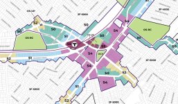
The Boston Zoning Commission this morning approved changes to Roslindale Square zoning that could mean buildings as tall as ten or twelve stories in a stretch from the commuter-rail station down South Street.

Denser zoning approved for Roslindale Square
The Boston Zoning Commission this morning approved changes to Roslindale Square zoning that could mean buildings as tall as ten or twelve stories in a stretch from the commuter-rail station down South Street. Read more.
Attachments
BronsonShore
Active Member
- Joined
- Feb 13, 2014
- Messages
- 520
- Reaction score
- 1,645
Denser zoning approved for Roslindale Square
The Boston Zoning Commission this morning approved changes to Roslindale Square zoning that could mean buildings as tall as ten or twelve stories in a stretch from the commuter-rail station down South Street. Read more.www.universalhub.com
Wonderful! But the 12-story zoning is limited almost entirely to the existing MBTA parking lot, so I'm not exactly confident of anything getting built there any time soon.
And I believe that state property is exempt from local zoning laws anyway? I vaguely remember reading this in one of the streets and squares reports.Wonderful! But the 12-story zoning is limited almost entirely to the existing MBTA parking lot, so I'm not exactly confident of anything getting built there any time soon.
I think overall this is a big step in the right direction. I’d like to have seen an even more aggressive change, but at least it significantly zones up the square itself and most of Washington St.
My hope is that the portion of South between Washington and Belgrade can get a few new buildings… a lot of these storefronts have been empty for years, and it’s highly underutilized space.
stick n move
Superstar
- Joined
- Oct 14, 2009
- Messages
- 13,480
- Reaction score
- 24,527
Nothing better than an LOI with a rendering

“Hebrew SeniorLife (HSL) proposes to build a 78-unit affordable senior housing community in partnership with the BHA/HUD through the Restore Rebuild program. The project will be located at the corner of Centre Street and Walter Street in Roslindale on a site owned and operated by HSL. The HSL campus includes a comprehensive healthcare and research facility that provides a range of services to seniors, from rehabilitation and outpatient care to end-of-life support. The proposed development will repurpose an existing parking lot, comprising 0.78 acres of the 9.4-acre site. No buildings will be demolished as no structures currently occupy the space. The proposed 78 unit, six-story, new construction, elevator building will be approximately 81,500 SF and will consist of 74 one-bedroom units (averaging 625 square feet) and 4 two-bedroom units (averaging 939 square feet).”
 www.bostonplans.org
1200 Centre Street
“Hebrew SeniorLife (HSL) proposes to build a 78-unit affordable senior housing community in partnership with the BHA/HUD through the Restore Rebuild program. The project will be located at the corner of Centre Street and Walter Street in Roslindale on a site owned and operated by HSL. The HSL campus includes a comprehensive healthcare and research facility that provides a range of services to seniors, from rehabilitation and outpatient care to end-of-life support. The proposed development will repurpose an existing parking lot, comprising 0.78 acres of the 9.4-acre site. No buildings will be demolished as no structures currently occupy the space. The proposed 78 unit, six-story, new construction, elevator building will be approximately 81,500 SF and will consist of 74 one-bedroom units (averaging 625 square feet) and 4 two-bedroom units (averaging 939 square feet).”
1200 Centre Street | Bostonplans.org
Development Projects and Planned Development Areas (PDAs) that the Development Review division is coordinating.
It’s not going to be an architectural masterpiece, but it does two important things: 1) it walls off the Hebrew Rehab, which is a hideous eyesore, and 1) it encloses Centre, which is a much better urban aesthetic and it might even help reduce speeds, since being closed in rather than having a big wide lawn to the driver’s right tends to make people feel more surrounded by humans and less of a drag strip mentality. I hope they pass this and build it quickly.Nothing better than an LOI with a rendering
1200 Centre Street
View attachment 63383
“Hebrew SeniorLife (HSL) proposes to build a 78-unit affordable senior housing community in partnership with the BHA/HUD through the Restore Rebuild program. The project will be located at the corner of Centre Street and Walter Street in Roslindale on a site owned and operated by HSL. The HSL campus includes a comprehensive healthcare and research facility that provides a range of services to seniors, from rehabilitation and outpatient care to end-of-life support. The proposed development will repurpose an existing parking lot, comprising 0.78 acres of the 9.4-acre site. No buildings will be demolished as no structures currently occupy the space. The proposed 78 unit, six-story, new construction, elevator building will be approximately 81,500 SF and will consist of 74 one-bedroom units (averaging 625 square feet) and 4 two-bedroom units (averaging 939 square feet).”
1200 Centre Street | Bostonplans.org
Development Projects and Planned Development Areas (PDAs) that the Development Review division is coordinating.
I do think it’s a travesty that the city sold the land to the rehab in the 60s, though. Between the Arboretum, Allandale Woods, and the Urban Wetland nearby, we could’ve had all of these linked via greenway instead of an institution that’s promised for years to reduce cars and parking and has only expanded in various sneaky ways. One actual and achievable goal would be to agitate to get them to put a small greenway and restore the Bussey Brook, eg to a 15 ft wide stream and green bank. This could be done with minimal impact on the parking.