Take Back The Streets (...and alleys)

The killer is the fire station at 392 Hanover, Boston Fire Department Engine 8 Ladder 1.
Thanks. Yeah, I've heard that before about the fire station, but I haven't seen a good explanation why that is actually a problem. It looks like you could have 10 feet on each side of the street for café space, and leave a 30+ foot wide path down the middle for pedestrians and emergency vehicles. If a firetruck needs to come through, pedestrians get out of the way. Just like cars do now, except the pedestrians can get out of the way faster than gridlocked cars.

What am I missing here?
 
A pernicious and deeply cultural status quo bias that looks for any reason to NOT do something rather than picking a vision and committing to it. I love your idea, sounds great. Someone is going to complain about parking and mention how long they’ve lived in the neighborhood and that’s it.
 
Cambridge City Council recently voted to open part of Memorial Drive as a park for full weekends this year. But it looks like Mass DCR, which controls the road, isn't actually closing the road, at least on Saturdays.

 
Mass DCR, which controls the road, isn't actually closing the road, at least on Saturdays.
Just a note that this fight to keep Memorial Drive open to bikes and pedestrians is still going on. There's a rally in the park this Saturday.
 
Amazing that there isn’t already one in Rozzie Square.
Birch Street is already permanently pedestrianized. Usually Rozzie Village Main Streets sponsors a couple of events that close Poplar Street. I guess if it's already happening through local activism, the city doesn't need to get involved?
 
Then came COVID. In a bid to help small businesses, and draw customers from their homes, city officials closed Moody Street to vehicular traffic and allowed patios to sprawl out onto the pavement. The thoroughfare became a destination, a model quickly copied by other cities throughout the region.
[...]
In summertimes since, Waltham has continued to experiment with the al fresco concept, shutting down the street for several months or on varied nights of the week. Now, the city’s studying a more permanent approach, making Moody Street one-way — either north or south — or closing it to cars entirely and creating a pedestrian mall.
 
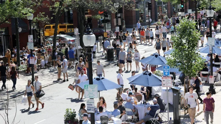
The Cambridge City Council passed a motion to close a block in Harvard Square traffic to allow for outdoor dining spaces on Monday. Blue Bottle Coffee, Daedalus Restaurant and Sea Hag Restaurant & Bar will have back patio spaces on Lower Bow Street beginning in the spring, according to Cambridge Day.
Between Dewolfe Street and Plympton Street, Lower Bow Street has been closed due to construction for two years “without causing significant impacts on the safety or functionality of the surrounding traffic patterns,” Cambridge Transportation Commissioner Brooke McKenna wrote in a statement to the city manager.
McKenna continued, “This has demonstrated that from a traffic perspective, this location is an excellent opportunity for pedestrianization. In addition, during COVID, the adjacent restaurants, with front doors on Mt. Auburn Street, had robust outdoor dining on Bow Street with great success.”
[...]
On Monday, Nolan said Bow Street “seems to be an ideal way to try [automatic bollards] because it’s such a small, very specific street.”
In response, Deputy City Manager Kathy Watkins said, “It is just a significant maintenance issue that we feel like there are better solutions that don’t require that level of maintenance and that level of complexity.” She also noted that most of the city’s removable bollards are not reinstalled.
Nolan asked the city managers to consult other cities that use the automatic bollards, noting the bollards are popular in Europe, because she believes they could be a cost saving method in the long term, she said.
 
Coming back to this...
That's great they're pedestrianizing that block, but jeez I wish they would also pedestrianize the other two useless blocks of Bow Street there. Apparently I've said this before, but the next couple blocks from Plympton to Holyoke also serve zero value for traffic. They should be pedestrianized.

It would be really useful to turn the block of Bow at Holyoke and Mt Auburn into a plaza, especially. That's the corner where tour buses drop off visitors. Literally hundreds of people regularly get dropped off onto the narrow Mt Auburn sidewalk. No one can get through. People organizing those trips look like they're running into the bike lane and traffic to get around and coordinate people. If there was a plaza there, it would be a great spot for those groups getting dropped off.

I'm just thinking about it because I happened to be going through there yesterday morning. I got his picture showing off how we use our limited street space. Hundreds of people crammed into a narrow sidewalk on one side. On the other side, vast empty asphalt for a redundant, unused street.

1759732304784.png


1759732326892.png
 
Here's an IMO not-so-crazy pitch: pedestrianize Harvard Square itself. Close off JFK St. between the T and Mt. Auburn, Brattle St. between the T and Brattle Sq, and the southbound lanes of Mass Ave. between the T and Church St. You can reverse the direction of Brattle St. up to Mason St. so that Church-Brattle-Mt. Auburn can serve cars trying to move SE through the square. Cars coming up JFK and going north can use Mt. Auburn and Holyoke to reach Mass Ave.
 

The Cambridge City Council unanimously approved a policy order Monday night to pedestrianize Brattle Street by restoring two-way traffic to John F. Kennedy Street.

The measure establishes a pilot program intended to reconfigure traffic flow in Harvard Square without hiring consultants or commissioning a formal pedestrianization study, an approach supporters described as cost-effective.

[...]

“The city had appropriated $300,000 for a pedestrian study,” [Councilor Simmons] said. “We feel that bringing in an outside group to tell us what we already know is not the best use of tax dollars at a time when the city is really trying very hard to reduce expenses.”
 
So, my apologies to the writers at the Crimson... but I think they are misconstruing the policy order a bit. Its two pieces. They're looking at a pilot program for Dunster, Palmer and Winthrop streets, all of which are great candidates for pedestrianization, and not main thoroughfares, to be prioritized in 2026. They're then asking the City Manager to consider, in the medium term, "how additional pedestrianization of a section of Brattle Street by restoring two-way traffic to JFK Street could enhance the Square." The , and clause in the order is kinda important.
1000043512.jpg

That said, by the reference to making JFK two way, I'm assuming they're thinking of the segment between Mass Ave and Brattle Square, on that triangular block. In principle I like the idea, in practice I actually think thats going to be challenging to pull off for a few reasons. Firstly, JFK at Mt. Auburn - even removing the parking on the east side, I think you would struggle to fit a turn lane in that segment that provides enough capacity for the amount of vehicles that are making the eastbound Mass Ave to Mt. Auburn movement, which currently "loop" via Brattle and queue on Mt Auburn for that movement. That segment of Mt Auburn between Eliot and JFK would be very difficult to treat - accommodating westbound traffic turning onto the bulk of Brattle, through traffic on Mt Auburn, the 2 way segment would have to be complete through Eliot, which is presently the most congested part of Harvard Square... I think theres a solution here, I don't think its a great idea to pilot it without actually designing and modeling it.

Personally, and something I'm going to think about writing an email to the city about, I think I'd rather pedestrianize JFK? It would require a bit more than a pilot program can bite off, but I think I'd rather send JFK's northbound traffic via Eliot and Brattle, than the inverse. Eliot and Brattle have the wider pavement already, more forgiving geometry and movement space.
 

Attachments

  • City Council Report.pdf
    113.7 KB · Views: 26
Personally, and something I'm going to think about writing an email to the city about, I think I'd rather pedestrianize JFK? It would require a bit more than a pilot program can bite off, but I think I'd rather send JFK's northbound traffic via Eliot and Brattle, than the inverse. Eliot and Brattle have the wider pavement already, more forgiving geometry and movement space.

Alternatively (and ironically maybe even the best for traffic flow): pedestrianize BOTH Brattle and JFK. Northbound traffic on JFK flows via Mt. Auburn and Holyoke St. to Mass Ave. Southbound traffic on Mass Ave flows via a newly one-way Church St. and a reversed-direction Brattle to Mt. Auburn or Eliot/JFK.
 
Alternatively (and ironically maybe even the best for traffic flow): pedestrianize BOTH Brattle and JFK. Northbound traffic on JFK flows via Mt. Auburn and Holyoke St. to Mass Ave. Southbound traffic on Mass Ave flows via a newly one-way Church St. and a reversed-direction Brattle to Mt. Auburn or Eliot/JFK.
Personally, I don't like the idea of using Holyoke for 2 reasons: 1) that trio of >90° turns would absolutely suck and kill throughput, especially for anything bigger than a car - I sincerely doubt the Harvard shuttle buses can make either turn. Those 90° left turns crossing major pedestrian axes on Mass Ave and Mt Auburn are not good for pedestrians or vehicles - i think something like left turning traffic causes something like 3x the major injury or deaths compared to a right turn. The same applies to Church, where I think southbound 66/86 buses would also struggle. 2) using Holyoke actually keeps cars in the core of Harvard Square for substantially more distance, with more obvious conflict points. That crosswalk at Mass Ave & Holyoke is already a mess, and I would really not want more traffic there. Edit to Add 3) - you're also asking a lot of of the quite narrow Mt Auburn Segment between Holyoke and JFK, as in your model it'll be asked to carry basically every movement through the square.

Since the built environment around Brattle/Eliot is already much more vehicle oriented with slip lanes and curves, might as well confine things there - either way, unlike the "side" streets, I think this one actually needs some study and modeling.
 
Last edited:

Back
Top