Transit via the Grand Junction Corridor | Cambridge and Boston

bigpicture7

Senior Member
Joined
May 5, 2016
Messages
3,747
Reaction score
8,608
I'm starting this thread for any/all projects or studies related to transit on the Grand Junction Corridor. While there have always been good reasons to post information about this topic elsewhere, given the inconsistency of where these things have been landing (e.g., general infrastructure, I-90/West Station, etc), it seems we are in need of a dedicated thread.

Thanks to @#bancars for posting this most recent update from Cambridge's Grand Junction Transit Feasibility Study:
 
I'm just going to restate what @Badusername said in the other thread because I don't think we actually talked about the premise enough. Could you run an elevated rail line along the Grand Junction, or more specifically, could you run an elevated rail line above Vassar St where that's definitely not possible? That would be huge, because if you can do that then that opens up almost an entire easily grade-separated E-W corridor for a new subway line, running from Waltham, following the Watertown Branch to well, Watertown, then running elevated above Arsenal St and then the Pike to West Station, then finally following the GJ to Sullivan. (Future expansions could branch to either Linden or Wonderland via Chelsea/Revere but those require actually putting in effort to build an ROW)

If you can fix the few discontinuities where you'd need short, shallow tunnels and a couple shallow stations (Waltham Station, Watertown Mews and a couple more parcels along Pleasant St, and Watertown center), and then string everything together, the entire 10 mile ROW is right there since this basically strings together by using the mostly intact Watertown Branch, the Pike, the Grand Junction, and some of the streets best suited for an elevated rail line potentially anywhere in Greater Boston.

And obviously if we ever wanted to build the rest of the Urban Ring then the Grand Junction portion could also be used for that.
 
Last edited:
I've never really thought about where a Grand Junction line might go once it crosses under the BU bridge, I have generally felt that elevated rail would work best. It would leave the option of continued main line use, leave room for a mixed use path, and avoid traffic disruption where it crosses key arteries.
 
... Could you run an elevated rail line along the Grand Junction, or more specifically, could you run an elevated rail line above Vassar St where that's definitely not possible? That would be huge...
There's been a ton of commentary on this on aB but it's been such a patchwork across different threads. Summarizing some issues from memory, I think the main challenges with a fully grade separated solution between the Technology Sq. area of Kendall and the Metropolitan Storage Warehouse across Mass Ave. are the height clearance restrictions due to air rights buildings on the Mass Ave-Main St. block of Vassar (in the positive vertical direction) and yet, in the opposite elevation direction, not being able to dig under Main St due to the Red Line tunnel (and even if you did, it'd be super deep). And then, of course, the grade steepness issues ascending/descending to either.

So the question for me is: is there enough height clearance in the Mass Ave-Main St. stretch to do a partial elevated solution yet still fitting beneath the buildings so you could do a reasonable-enough-slope elevation change to get over the humps of Mass Ave and/or Main. It seems like that would be pretty ugly -- but damn useful if it could be pulled off.
The solution to this problem that @Badusername proposed would be to basically just avoid it entirely by running the elevated across the MIT visitor lot and then running above Vassar St, then rejoining the Grand Junction ROW somewhere after crossing Main St, probably next to Draper since the Novartis complex gets pretty close to the GJ as well.

Vassar St is hardly an ideal corridor for elevated rail but at the same time it's not that bad (Only two major stakeholders, Cambridge and MIT, with primarily commercial/office land-use rather than residential), and as you mention the MASSIVE benefit of having basically an entire quarter of the Urban Ring practically right there on a platter is quite the consolation.
My apologies, my brain read your post as referring to that block of Vassar, not the actual street itself, but I get it now. I agree it would be majorly beneficial for transit purposes (aesthetics aside)

I'd add another big stakeholder, though, which is Eversource / Greater Cambridge Energy Project (GCEP). Aren't they about to dig up Vassar for it to serve as a primary utility trunk to the massive underground substation u/c at the MXD site?
That's fair, I wasn't aware of that project. If working around their power lines to build elevated supports isn't possible (or more likely, not cost effective) then Albany St could maybe work, but it gets quite narrow. It would probably fit, but probably with no more than 10ft between the trains and the buildings. If that's too big of a drawback then you could maybe run one direction along Portland St but that would require a ~60ft radius curve to get onto Main St.

That being said, I find it fairly unlikely that none of those are feasible. Given how open the rest of the ROW is, adding a bit of cost here by going with a slightly more expensive option like the split tracks on Portland/Albany is really not the end of the world as I think it would take a hugely expensive requirement (such as a deep tunnel) to really alter the cost/benefit analysis significantly.
 
Run the GJ at grade and close Main St. and Mass Ave. to all vehicular traffic except buses.
 
Run the GJ at grade and close Main St. and Mass Ave. to all vehicular traffic except buses.
That's going to cause more mobility problems than it's worth given the transit ridership projections vs. utilization of the roads impacted. Read the 2012 study. It did detailed traffic counts at the three major crossings, and broke it down multimodally by car, bus, pedestrian, and bike. Everyone sees unfavorable delay time with gates down...including the buses/peds/bikes.

I said this in the other thread: LRT and BRT have no problems with the Main and Broadway crossings because the crossings are at pre-existing traffic signals and LRT and BRT can share a signal phase. The transit phase slips in as inocuously as a pedestrian phase because transit's an orderly participant in the signaling. And Mass Ave. can easily be eliminated with a ROW-over-road bridge at 4% transit grades. It's only with RR mode that you have a mess on your hands. Priority is absolute for the mainline trains, and the only signaling tricks you can pull are purely reactive queue-dump cleanup after the fact. And Mass Ave. crossing can't be eliminated at 2% FRA grades; it infringes on the air rights overhang downstream. The current study not only put its finger on the scale for the by-far most traffic-disruptive mode, but it eschewed all of the traffic modeling of the 2012 study to bury the messy impacts of gates-down every 7.5 minutes at those 3 chokepoints.
I'm not saying to put gates down there, I'm saying to eliminate those roads to all private automobile traffic permanently.
 
I'm not saying to put gates down there, I'm saying to eliminate those roads to all private automobile traffic permanently.
You have to have gates there. It's an FRA rule for crossings above a certain train traffic threshold. And Mass Ave. (the worst crossing) is state highway 2A, so MassHighway is not going to allow you to close it to autos.

What I'm saying is...the previous study found punitive delay time for the not-automobiles too. Including the buses, pedestrians, and bikes. The #1 bus carries more daily ridership than this proposal, and it racks up delay time because of that crossing. It's inconveniencing more riders than it's helping.
 
I'm not saying to put gates down there, I'm saying to eliminate those roads to all private automobile traffic permanently.
Like it or not, roads are useful for moving people and goods from one place to another, and Mass Ave and Main St are important corridors for doing so as they connect to 2 of the 3 river crossings between Allston and Downtown. Maybe (and this is still a big maybe) in some fantasy land you could get away with closing or severely restricting traffic on one, but you're not getting away with both.

Even if you completely ignore that, having crossing gates come down every 7.5 minutes would even be disruptive for bikes, which would presumably be the ones filling in the gap left by all that unused road space. If I'm ever cycling in the city center I'll sometimes run into a bridge raising, and even though those only take a minute, maybe two, you still end up with potentially 100+ bikes stuck waiting at some of the busier crossings during peak periods.

You have to have gates there. It's an FRA rule for crossings above a certain train traffic threshold.
Even if we don't just take the FRA guidelines as absolute laws of the universe, having a busy crossing without gates, even if it's bikes and/or pedestrians, is bad. People are morons, and CR trains, even EMUs, can't stop on a dime unless they're going incredibly slowly. Hence gates to ensure trains can move at a speed greater than 5MPH and people don't die regularly.
 
They don't even spec full-high 48 inch platforms. They go with 14 inch x 250 ft. LRT level-boarding platforms, meaning that the service is captive to unicorn rolling stock and requires low platforms (or low platform extensions) to be built on all the "extended"-service stations like Sullivan, Everett, Chelsea, and Lynn if they buy a low-floor make. The only rolling stock on the planet that can interoperate between full-highs and level lows without requiring station mods is the boondoggly and expensive Caltrain-mod Stadler KISSes. What an absolutely stupid constraint to sandbag the project with. If it's going to be RER mode, it's got to be able to take all manner of RER equipment and that means 48-inch platforms (I don't care if they're short length because no other CR service is going to be using them, but at least make it boarding-compatible with the scale we already have). Specialization for a niche service within the mode is cost-lethal to the project. If it's going to be EMU's or BEMU's, it's got to be the same EMU's or BEMU's we run everywhere else on the system. If Fairmount isn't being held to this extreme specialization standard, why would we ever do it here on an ultimately lower-ridership service?

Building and operating it this way would presumably preclude any kind of Framingham-North Station service having stops in Cambridge which would be an actual benefit of choosing that mode.
The LRT and RER both have forced transfer at West, but the LRT would presumably have higher frequency than RER.
 
Building and operating it this way would presumably preclude any kind of Framingham-North Station service having stops in Cambridge which would be an actual benefit of choosing that mode.
The LRT and RER both have forced transfer at West, but the LRT would presumably have higher frequency than RER.
The 2012 study looked at exactly that: Worcester-NS. And found less demand for it than demand continuing on the mainline to Lansdowne and Back Bay. As well very little demand on off-peak hours when the Red Line and Orange Line were functioning better for making the same trips in similar time. It got a not-recommended rating because of these demerits. We've pretty much proven that MetroWest ridership is not going to move the needle in favor of a Grand Junction routing, and simply fixing the subways with RLT/OLT largely licks the peak-hour preference for the CR routing by making the subways function better under load.

This current study didn't even find enough Newton ridership affinity to bother pitching it as a Riverside turn.
 
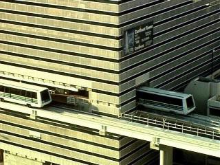
I realize that the answer is fully likely to be "it's not cost effective" but if we wanted to build an elevated LRT wholly on-corridor, how much additional height do we need under the air rights to allow for all uses to coexist?

Specifically, I'm wondering if the cost of modding MITs buildings by removing the bottom air rights floors to create space for an LRT RoW or building an elevated station into the McGovern building is worth considering as a high-level concept. As an example, I'm thinking of something like Miami MetroRail's Knight Center station, which, if an uncited Wikipedia article is to be trusted, was built into the existing structure.
miami1.jpg
 
In
I realize that the answer is fully likely to be "it's not cost effective" but if we wanted to build an elevated LRT wholly on-corridor, how much additional height do we need under the air rights to allow for all uses to coexist?

Specifically, I'm wondering if the cost of modding MITs buildings by removing the bottom air rights floors to create space for an LRT RoW or building an elevated station into the McGovern building is worth considering as a high-level concept. As an example, I'm thinking of something like Miami MetroRail's Knight Center station, which, if an uncited Wikipedia article is to be trusted, was built into the existing structure.
miami1.jpg
I've thought the same thing about modifying the MIT building to create a second story passthrough portal for the elevated LRV structure. Another alternative would be to have the elevated rail placed on top of the existing building. It would raise the elevated structure a few stories higher through this section, and might require a cable-stayed or an arch bridge, but I think it's probably doable and might add an iconic, cool looking structure if done right.
 
I realize that the answer is fully likely to be "it's not cost effective" but if we wanted to build an elevated LRT wholly on-corridor, how much additional height do we need under the air rights to allow for all uses to coexist?

Specifically, I'm wondering if the cost of modding MITs buildings by removing the bottom air rights floors to create space for an LRT RoW or building an elevated station into the McGovern building is worth considering as a high-level concept. As an example, I'm thinking of something like Miami MetroRail's Knight Center station, which, if an uncited Wikipedia article is to be trusted, was built into the existing structure.
Even if replicating the 5+% grades on the Science Park incline weren't possible, or if (partially) eating a floor or two of Building 46 wasn’t shockingly plausible, Grand Junction GLX starts at $2-3 Billion and escalates from there.

If built, this critical piece of rail will serve the beating heart of (America’s? The world’s?) biotech sector for the next 100+ years. One building is the reason that line will sit at a light, waiting for SOVs as if it was a pedestrian? One building is the reason that in the 2070s, the Urban Ring is mode-locked to light rail, rather than a higher capacity, lower OPEX automated metro?

If an elevated guideway through Building 46 is structurally infeasible, why is the only option to buy a tram for the cost of a rapid transit line, rather than buy a rapid transit line, for the cost of one building.

If a mere world class city would never settle for that trade, then certainly the self-proclaimed Hub of the Universe shouldn’t either.
It's not one building, it's THREE: Building 46, the Building 45 rear overhang, and the power plant.

LRT with traffic signals at a station stop isn't crap. You'll get your world-class rapid transit with the Main and Broadway crossings remaining. It's only Mass Ave. that must be eliminated because of too-awkward placement of signals.
 
Last edited:
I'd add another big stakeholder, though, which is Eversource / Greater Cambridge Energy Project (GCEP). Aren't they about to dig up Vassar for it to serve as a primary utility trunk to the massive underground substation u/c at the MXD site?
It seems likely that Eversource would be more amenable to elevated rail on this corridor than MIT. Looking at the Siting Board Decision (pages 66 and 71 in particular), MIT was opposed to the construction occurring on Vassar St due to the high density of existing utilities for their microgrid. They claim that along the entire Vassar St corridor, there are 527 utility crossings, which seem to be most dense around the power plant.

That's fair, I wasn't aware of that project. If working around their power lines to build elevated supports isn't possible (or more likely, not cost effective) then Albany St could maybe work, but it gets quite narrow. It would probably fit, but probably with no more than 10ft between the trains and the buildings. If that's too big of a drawback then you could maybe run one direction along Portland St but that would require a ~60ft radius curve to get onto Main St.

That being said, I find it fairly unlikely that none of those are feasible. Given how open the rest of the ROW is, adding a bit of cost here by going with a slightly more expensive option like the split tracks on Portland/Albany is really not the end of the world as I think it would take a hugely expensive requirement (such as a deep tunnel) to really alter the cost/benefit analysis significantly.
Stacking elevated tracks on Albany St should solve any concerns about being too close to buildings, and while it would be more expensive, it should not add that much cost. I would have to agree that between Vassar St, Albany St, and even remaining on the Grand Junction, there are absolutely reasonably priced ways to provide grade separation.

I would also like to point out that making the project an elevated/at-grade, light metro (think Vancouver Skytrain or Montreal REM) should do wonders for its constructability and cost. This means smaller stations, lighter viaducts, and easier construction with less unknowns. Prices of around $100 million dollars per kilometer should be feasible given how much grade separation is already provided (there are only 6 vehicle grade crossing between the proposed West Station and North Station). Even if there is not faith in the MBTA to deliver a project that cost-effectively, getting a fully grade-separated, high frequency metro on this corridor should absolutely be doable in the $1-2 billion range, even if it is built more expensively than necessary.
 
Prices of around $100 million dollars per kilometer should be feasible given how much grade separation is already provided
Let's say 2x that for the elevated sections, 5x for the cutting sections, and 10x for the short tunneled bits. That would put the total cost for the whole Waltham-Sullivan line at around $5 billion. So for about 1.5 South Coast Rails we could get a whole new subway line.
 

Back
Top