Underground station layouts

State will happen eventually, but it will take a while. It's easily the most difficult for me to do - curved and stacked platforms, very little visible on the surface, and no recent projects with maps of the OL portion. The Blue Line portion does have some renders from the 2006-2011 project, including a decent view of the curve.
I did find a couple of fire maps at State that could help out. The fire maps are located in the Old Statehouse entrance of the station.
 
As requested, Government Center. The former Court Street station area is very speculative, and largely based off a handful of 2014 photos and a later-modified 1903 plan. Most of the former station area is now occupied by the Blue Line tunnel, the roof of which leaves enough room to walk on.View attachment 4827
I don't know if this has been asked before, but is there a link to the Google MyMaps file? It would be nice to see what has been of the whole system so far.
 
I don't know if this has been asked before, but is there a link to the Google MyMaps file? It would be nice to see what has been of the whole system so far.
It's still very much a work in progress (and occasionally I do make corrections), so unfortunately I don't share the full file publicly. I do plan to do so when I reach a reasonable state of completion - at least all of the underground stations - and also release it as KML and shapefiles.
 
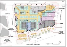
I was at Haymarket a couple of months ago, there's an emergency exit on the northbound platform near the southern end of the platform. The surface doors are in the same building as the Orange Line lobby. You can see the surface doors on Google Street view, it's a set of red unmarked double doors. I'm not sure how the stairs are positioned, but it is definitely there.
Good catch! I'll see what I can track down; it unfortunately doesn't show on the fire alarm diagram in the station. If anyone knows of plans for the Parcel 7 (Public Market) building that show them, please let me know.
 

Back
Top