West Cambridge / Alewife Area Infill & Small Developments

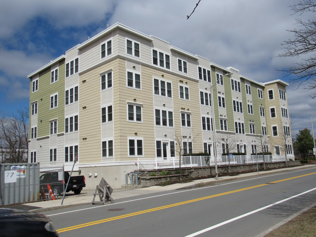
It seems to me that they built a car-dependent neighborhood next to a subway station. Maybe that is what this area should be because it's the end of the line and the transition zone between urban and suburban, but I think it could have been so much more. I suspect a lot of the people who chose to live here will be commuting in on the red line, but many others will be commuting out on route 2 by car and only going into Boston on night and weekends. Perhaps the ideal residents here would be a couple that is split - one going into Boston and the other going out to the office parks.

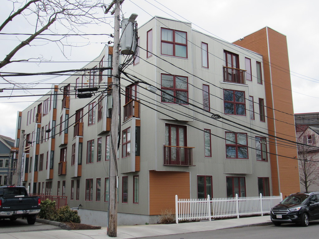
Aside from commuting, this whole place looks completely auto-oriented. Where are the restaurants, bars, grocery store, pharmacy, etc? Is there any hope that the residents of these zillion new homes can do anything in their own neighborhood? We need homes, yes, but people should be able to leave those homes without employing a 2 ton automobile or a 2000 ton train.

Housing crisis: check
Transportation and energy use crisis: meh

24 hour CVS is close by (walking distance) as is Trader Joes, Whole Foods, Summer Shack and a cinema.
 
I work in this area, and it is somewhat of a hellscape. Personally, I think they need to create another access point to Route 2, because for now everybody is funneled back onto Alewife Brook Parkway and it turns into a parking lot for hours at a time. It's very inefficient to force all of the cars onto the same clogged road in order to navigate in and out of the area. Route 2 West never clogs within the first few miles of Alewife so it would be very useful to have another outlet from the neighborhood onto the highway to relieve the stress on Alewife Brook Parkway.

This area is what I call "edge city" as it's the unofficial delineation point between urban and suburban. Most people here are driving in from the suburbs, either to take the trains from Alewife or to work. Is there some sort of plan to deal with all the extra traffic being created by these new developments?
 
24 hour CVS is close by (walking distance) as is Trader Joes, Whole Foods, Summer Shack and a cinema.

I am aware of the auto-centric businesses, with parking lots larger than the stores, that you can reach by walking a minimum of half a mile along a highway. That's not really part of a functioning walkable neighborhood. Its a technicality.

Let's go to that Whole Foods after work one day or on a nice-weather Saturday and survey how many customers arrive on foot, bike, and car. I predict 98% by car. Repeat the same experiment at the WF in Central Square or Inman - actual walkable neighborhoods - and I bet you get about 10% or less by car.

I'm not trying to get into a pissing contest. My position is that Cambridge has not done enough to create a walkable, non-auto-centric neighborhood around Alewife. I don't think that is controversial.
 
To me, the Alewife area is a perfect example how misguided it is for "community interests" (i.e., NIMBYs but also planning boards) to have such a laser focus on height. Height and "character" are in no way synonymous, but for some reason the powers-that-be lock onto height restrictions as some sort of cudgle that can purportedly be used to force character. But it doesn't work that way. All the new stuff around Alewife is relatively short (most of the new post-Recession stuff is five-over-one, some of the slightly older stuff is a actually bit taller), and the "neighborhood" is a lifeless, characterless, auto-centric void in the city. It's an open argument as to whether the total lack of urban vibrancy around there is a result of the height caps or just an unrelated coincidence, but I see no possible way in which allowing taller buildings there could possibly have made anything worse.

Unfortunately, the logic around so much design review goes something like this: "get the developers to propose something shorter, then approve it once it's short enough." This prevailing height focus crowds out any focus on quality. In a more sensible system, the powers-that-be whould allow developers to build taller (seriously, how would a, say, Fenway-sized building on CambridgePark Drive negatively affect anybody) then use that height to improve/underwrite quality in other ways. And I think this is something that the NIMBY crew and the YIMBY crew both miss; it's not a question of stricter regulations or looser regulations, it's a question of better regulations: be more lax in some areas (e.g., height), but demand more in others (e.g., street-level programming, access and egress, subsidized residential and commercial rents).

For example, Cambridge could have allowed x number of extra floors along CambridgePark Drive, but mandated that developers provide below-market ground floor retail space to local businesses. Or the City could have let the developers at Cambridge Discovery Park and along Route 2 build taller, but only allowed it on the condition that they come to an agreement so that everything built along Route 2 can front "Discovery Way" instead and not the highway (it absolutely blows my mind that there is no access between Acorn Park Drive and the building going up at the former Lanes 'n' Games site). I'm confident that allowances/agreements such as these would yield a better product overall. And the list could go on...
 
Last edited:
The whole area is also impacted by the fact that it’s ill-suited to be the terminus of the Red Line.
 
The whole area is also impacted by the fact that it’s ill-suited to be the terminus of the Red Line.

The Red Line should be expanded to 95 in Burlington and a giant garage built with direct access from 95. That would take care of a lot of the Rt 2, 3 and 93 issues. But of course it is wildly expensive and will never happen.
 
I think a part of the problem is those nearby projects. Might make the residents extra sensitive to height.
 
The Red Line should be expanded to 95 in Burlington and a giant garage built with direct access from 95. That would take care of a lot of the Rt 2, 3 and 93 issues. But of course it is wildly expensive and will never happen.

IMO it should branch to a Belmont-Watertown-Waltham line and an Arlington-Lexington-Burlington line.
 
I am aware of the auto-centric businesses, with parking lots larger than the stores, that you can reach by walking a minimum of half a mile along a highway. That's not really part of a functioning walkable neighborhood. Its a technicality.

Let's go to that Whole Foods after work one day or on a nice-weather Saturday and survey how many customers arrive on foot, bike, and car. I predict 98% by car. Repeat the same experiment at the WF in Central Square or Inman - actual walkable neighborhoods - and I bet you get about 10% or less by car.

I'm not trying to get into a pissing contest. My position is that Cambridge has not done enough to create a walkable, non-auto-centric neighborhood around Alewife. I don't think that is controversial.

So I guess my answer then is if you don't like it, don't live there. Having lived there myself, it served its purpose and was a nice place to live. You were right near the T and the walking paths in the area (although I wouldn't recommend taking the one behind the garage, apparently its an open sewer). Summer Shack and Bertucci's were right there. Not everybody wants or needs to density of Central Square which one could argue with the generally low height of its buildings is wasting valuable space.

Lastly regarding congestion in my experience its coming from the wealthy towns towards the west and not from the people in the apartment buildings nearby. The traffic isn't from people heading west up Rt 2. Its from everyone coming east from their leafy suburbs.
 
Color is good but the street level on all of these is pure garbage
 
The former Vecna building at 35 Cambridgepark Drive is now demolished.
wVT8XQM.jpg
 
Last edited:
Alewife District Plan was released, published by the City of Cambridge. Lots of ideas to digest, so I'll just leave the link and some renders for the urban planners to take on.
My disappointed thoughts on this enormous suburban office-park looking plan:
1) Why a bike path behind the fresh pond mall- where do they think people are coming/going from?This is an improved mobility plan without a vision for a Green Line extension?
2) Where is a Commuter rail station for this enormous office park they envision?
3) Why not add a plan to add another road entrance into Cambridgepark Drive over the rail ROW just to lessen the bottleneck?
4) "Evaluate a second bicycle/pedestrian bridge across Alewife Brook between Discovery Park and Cambridgepark Drive in the long term" and " design for a bridge could start three years after the new zoning is in place, with construction starting in six to seven years and completed at approximately
40% build-out." Have we not learned yet that transit access needs to come BEFORE buildout? This should be mandatory.


Alewife+Quadrangle
1571851169636.png


Fresh Pond market redevelopment
1571852648252.png
 
Last edited:
Alewife District Plan was released, published by the City of Cambridge. Lots of ideas to digest, so I'll just leave the link and some renders for the urban planners to take on.
My disappointed thoughts on this enormous suburban office-park looking plan:
1) Why a bike path behind the fresh pond mall- where do they think people are coming/going from?This is an improved mobility plan without a vision for a Green Line extension?
2) Where is a Commuter rail station for this enormous office park they envision?
3) Why not add a plan to add another road entrance into Cambridgepark Drive over the rail ROW just to lessen the bottleneck?
4) "Evaluate a second bicycle/pedestrian bridge across Alewife Brook between Discovery Park and Cambridgepark Drive in the long term" and " design for a bridge could start three years after the new zoning is in place, with construction starting in six to seven years and completed at approximately
40% build-out." Have we not learned yet that transit access needs to come BEFORE buildout? This should be mandatory.


Alewife+Quadrangle
View attachment 840


Fresh Pond market redevelopment
View attachment 841
A major fail without a 2nd point of entrance for cars and trucks to / from Cambridge Park Drive

This needs to be a Network -- the idiot transportation planers should be required to take a EE Course in Networks and Systems
 
Alewife District Plan was released, published by the City of Cambridge. Lots of ideas to digest, so I'll just leave the link and some renders for the urban planners to take on.
My disappointed thoughts on this enormous suburban office-park looking plan:
1) Why a bike path behind the fresh pond mall- where do they think people are coming/going from?This is an improved mobility plan without a vision for a Green Line extension?
2) Where is a Commuter rail station for this enormous office park they envision?
3) Why not add a plan to add another road entrance into Cambridgepark Drive over the rail ROW just to lessen the bottleneck?
4) "Evaluate a second bicycle/pedestrian bridge across Alewife Brook between Discovery Park and Cambridgepark Drive in the long term" and " design for a bridge could start three years after the new zoning is in place, with construction starting in six to seven years and completed at approximately
40% build-out." Have we not learned yet that transit access needs to come BEFORE buildout? This should be mandatory.

No disagreement on the spectacular (but sadly expected) fail on including the CPD road bridge (although I've heard reasonable arguments against - consider the vertical clearance and where an approach would need to begin on the north side). To your other points:

A Green Line extension along this ROW has never been proposed or discussed anywhere other than in our Crazy Transit Pitches thread. It's decades away if it ever happens. I understand that this is a long-range vision document, but the commuter bikeway from Watertown is something that exists right now and has a gap on that segment. Alewife is already the terminus of another hugely successful commuter bikeway. Bikeways like the Minuteman are effective transportation corridors.

I have yet to see an "office park" that has unbroken 4-5 storey streetwalls. I realize that the art style isn't crisp or hip, and I realize the risk of derailing another thread with this "Route 128" thing, but it's not an office park. The massing on the south side of the tracks is smaller footprints than the existing CPD buildings.

EDIT AS I READ:

Worth noting that this plan takes an idea off of F-Line and jogs CPD to connect directly to Rindge (they call it "straightening" though it's in fact the opposite). This is a great idea and absolves them somewhat for not even mentioning connecting the other end. The plan establishes pretty quickly that it sees the western end of CPD as set in stone and unsalvageable.

Pictured: not an office park.

1571860676359.png
 
Last edited:
As someone who used to work in the area so Im pretty familiar with the workings of the area... yea this isnt perfect, but reading through that document its a MASSIVE upgrade to what is there. This area is never going to be davis sq, but I think it will be fine for what it is.

What it has going for it is lots of green space, walking trails, soccer fields, ponds, and also lots of new build condos. So I think it can be an area thats close to transit and lots of green space, that can fit a lot of housing that wont be top dollar. So I can see people living here who want to be close to transit, but also be on the outskirts of the city and closer to parks and a short distance away from being able to get away from the city.
 

Back
Top