I-695, Soutwst X-Way, Mystic Valley Prkway, S. End Bypass

Yes, there are many highway lanes already going into Boston. You would have to add onto that the additional 20 lanes to handle the riders from the Red Line.

The current Red Line rush hour schedule is 9 minute headways per branch. That combines for an effective 4.5 minute headway on the trunk from Alewife to Columbia. I was also estimating a crush load on the Red Line of 250 people per car. The MBTA Blue Book lists all Red Line cars as having crush loads over 260, actually.

250 * 6 * 120 / 4.5 = 40,000 people per direction

So 80,000 combined is reasonable I think.
 
Wow, would have made quite a mess of the Ruggles area and the Fens parks in addition to Cambridge...
 
I-695 overlaid on top of a current Google Maps image. (takes a while to load.)

Also shows where Southeast Xpressway (from the south and Route 2 from the north where it was supposed to go along current Fitchburg line.

http://www.google.com/maps/ms?f=q&h....356134,-71.092358&spn=0.076365,0.181789&z=13

I don't understand how 95 was supposed to be routed between the cancelled SW and NE expressways. Via the Central Artery?

It couldn't have used the Inner Belt, that would have violated numbering conventions.
 
I-95 would have come up from Canton on the Southwest Expressway, than east along the Inner Belt to what's now the Roxbury/Mass Ave interchange of the Southeast Expressway, then up the Central Artery, then over the Tobin Bridge, through Revere, Lynn, Saugus to 128 where the current I-95 resumes.

I-93 would have ended at the junction with the Tobin Bridge in City Square, Charlestown. It would not have continued onto the Southeast Expressway -- that would have just remained MA 3.
 
I-695 overlaid on top of a current Google Maps image. (takes a while to load.)

Also shows where Southeast Xpressway (from the south and Route 2 from the north where it was supposed to go along current Fitchburg line.

http://www.google.com/maps/ms?f=q&h....356134,-71.092358&spn=0.076365,0.181789&z=13

The location of the NW Expressway you show at the Concord Turnpike isn't correct. The proposed NW Expressway route would have actually gone through where the current Alewife Red Line station is located, and joined the Concord Turnpike about a hundred feet west of the Route 16 (Alewife Brook Parkway) intersection. I grew up in North Cambridge, a teenager in the 1960's, and followed all the design proposals for the NW Expressway at the time.
 
I-95 would have come up from Canton on the Southwest Expressway, than east along the Inner Belt to what's now the Roxbury/Mass Ave interchange of the Southeast Expressway, then up the Central Artery, then over the Tobin Bridge, through Revere, Lynn, Saugus to 128 where the current I-95 resumes.

I-93 would have ended at the junction with the Tobin Bridge in City Square, Charlestown. It would not have continued onto the Southeast Expressway -- that would have just remained MA 3.

Okay, so if I'm following this right, then not all of the Inner Belt was actually to become 695. 695 would have ended at an interchange with 95 but the Inner Belt would have extended further east to connect 95, 93 and 3...

Wow, I do not want to even imagine what kind of spaghetti nightmare that junction would have been.

What would the current stretch of 93 between MA 3 and 128 have been? A 128 extension?
 
What would the current stretch of 93 between MA 3 and 128 have been? A 128 extension?

Before it was re-designated as 93, it was always 128. Route 128 circled the city, and for a while even continued southeast along Route 3 and ran north along what's now Route 228 to Hull.
 
Okay, so if I'm following this right, then not all of the Inner Belt was actually to become 695. 695 would have ended at an interchange with 95 but the Inner Belt would have extended further east to connect 95, 93 and 3...

Wow, I do not want to even imagine what kind of spaghetti nightmare that junction would have been.

What would the current stretch of 93 between MA 3 and 128 have been? A 128 extension?

There were dual naming conventions on several of the highways.
 
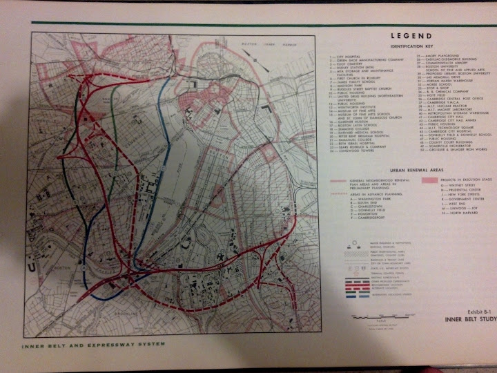
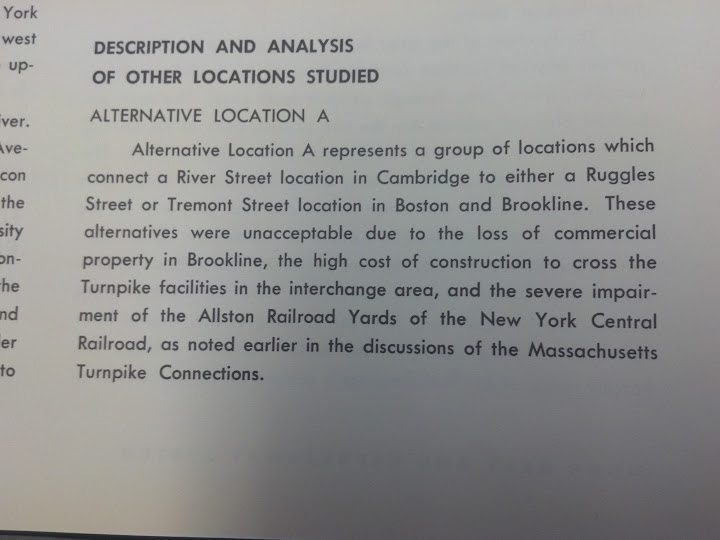
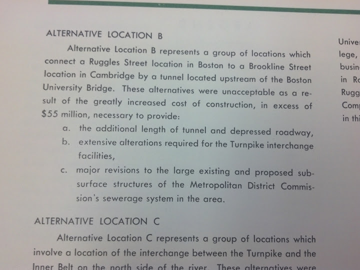
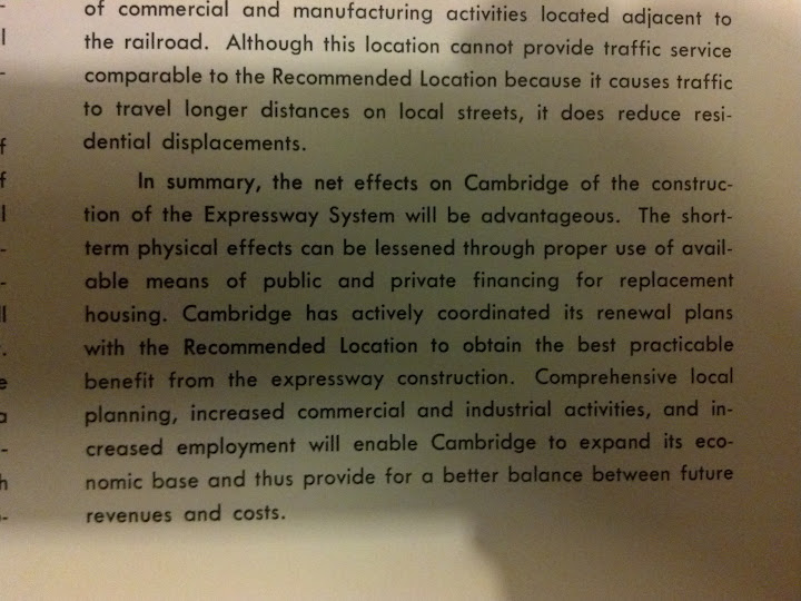
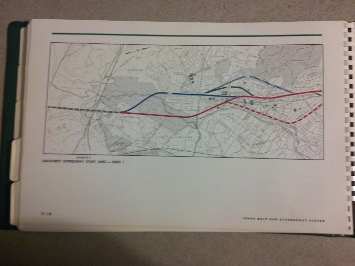
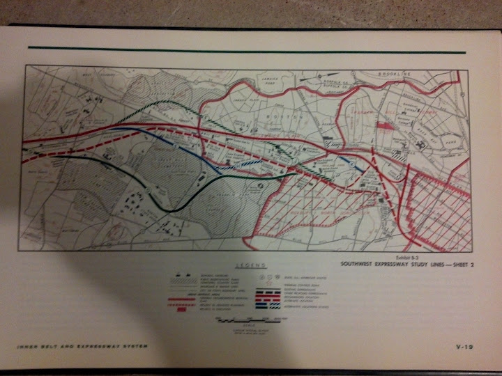
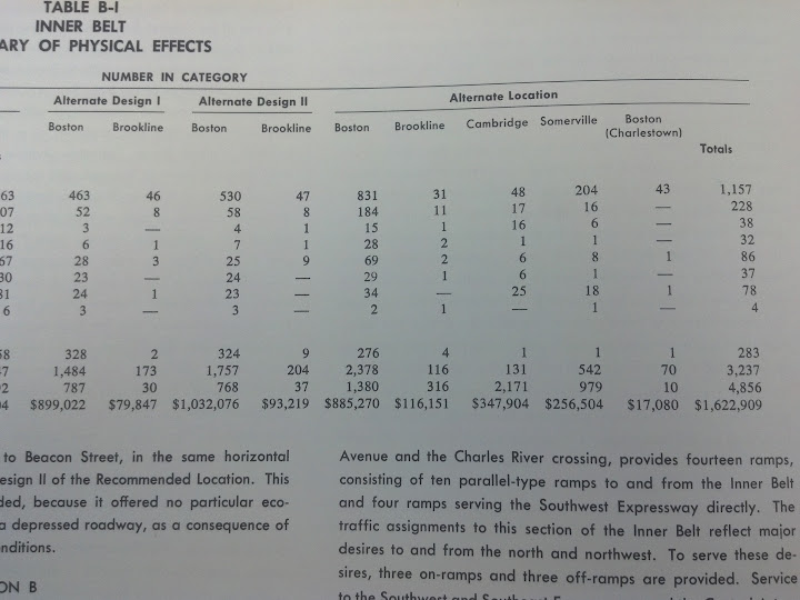
Here are the different alignments explored for the inner belt...

2012-05-10_22-11-27_330.jpg


2012-05-13_14-43-41_74.jpg


2012-05-13_14-43-49_785.jpg


2012-05-13_14-43-54_100.jpg


2012-05-10_22-09-46_590.jpg


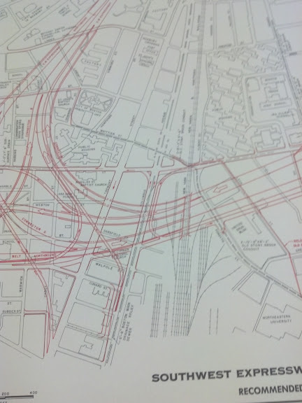
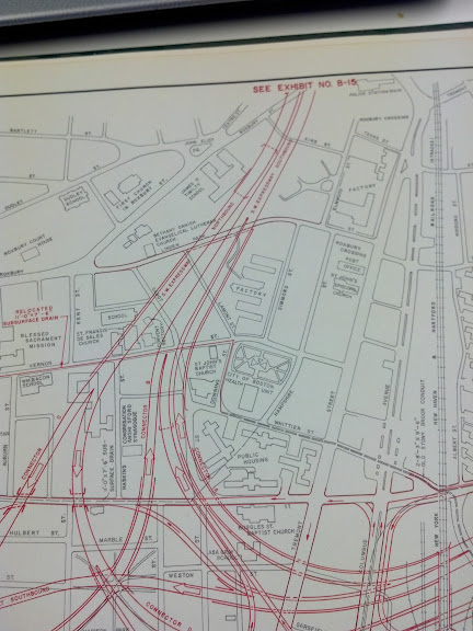
The solid red line is the recommended location

Southwest Expressway
2012-05-10_22-12-44_392.jpg


2012-05-10_22-12-39_385.jpg


2012-05-10_22-11-05_992.jpg


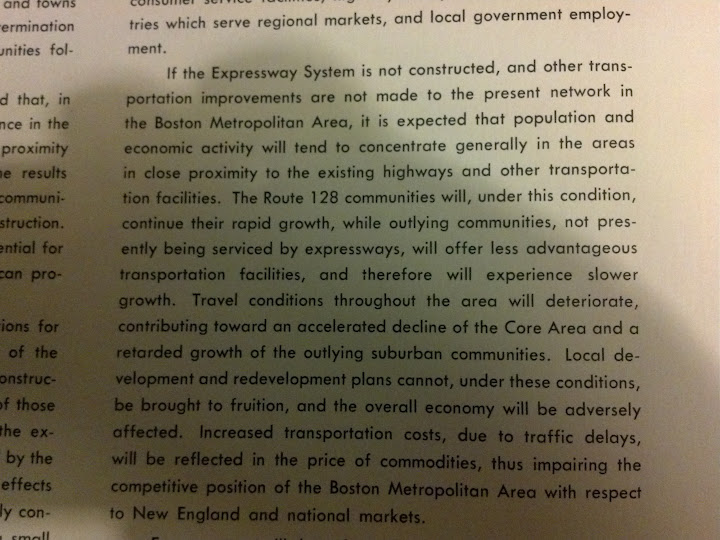
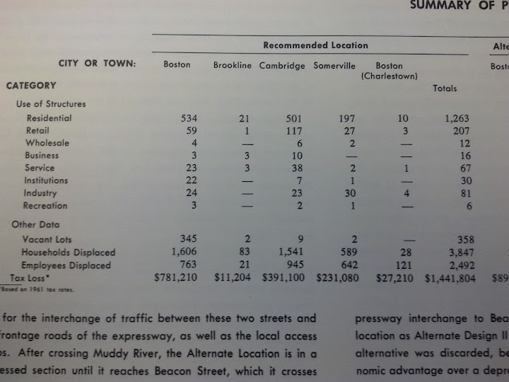
Cost of inner belt--- relocate about 4,000 people, have a functional highway system for a region of 6 million.

2012-05-13_14-44-11_346.jpg


2012-05-13_14-44-18_866.jpg
 
Directly across from Roxbury Crossing T. It includes air rights over the Orange Line too. The Southwest Corridor is a focus of my analysis.

This the recommended plan. I can take some photos of the alternate plan if you are interested.

2012-05-13_15-02-35_906.jpg


2012-05-13_15-02-31_914.jpg


2012-05-13_15-02-28_910.jpg


2012-05-13_15-02-18_694.jpg


2012-05-13_15-02-15_826.jpg


2012-05-13_15-02-10_960.jpg
 
I don't understand how 95 was supposed to be routed between the cancelled SW and NE expressways. Via the Central Artery?

It couldn't have used the Inner Belt, that would have violated numbering conventions.

On that Google Map, zoom out to see NE/SW expressway's better. The southern end of the SW Expressway would have roughly tied into that Canton interchange that was being discussed last week.
 
Last edited:
This is the mimimum that Cambridge would have been decimated by the cancelled expressways:

cambridgex-way.jpg

The western end might have faced problems.
1) Alewife Brook Parkway and Mystic Valley Parkway would have been Middlesex County's roads. Counties were still powerful at that time.

2)
The portion of connecto at the far northwest end is using the rail line of the Watertown Branch Railroad. That was one end of the Fitchburg Line's connections to the Watertown Armory. I'm uncertain the U.S. Department of Defense would have allowed it to severed from the national railroad network on the eastern end.
 
Wow, would have made quite a mess of the Ruggles area and the Fens parks in addition to Cambridge...

Ruggles was pretty flattened. Orange Line was still down Washington Street to Dudley at the time. The trench that was dug for SW Expressway became the Orange Line in 1988. Northeastern University recently put up a high-rise dorm next to the train-station on a parcel of land that was cleared out for a long time. Melena Cass Blvd. still has large parkland and places turned into parking areas on either side of the road. (minus some areas which have become developed in the last 10-20 years.)
 
The western end might have faced problems.
1) Alewife Brook Parkway and Mystic Valley Parkway would have been Middlesex County's roads. Counties were still powerful at that time.

2)
The portion of connecto at the far northwest end is using the rail line of the Watertown Branch Railroad. That was one end of the Fitchburg Line's connections to the Watertown Armory. I'm uncertain the U.S. Department of Defense would have allowed it to severed from the national railroad network on the eastern end.

The Parkways at the time were under the control of the MDC (Metropolitan District Commission), and the MDC was okay with the proposed connections to the NW Expressway.

The NW X-Way would have left the railroad lines in the area undisturbed. If you stand at the intersection of Rindge Ave and Alewife Brook Parkway today, the NW X-Way would have passed over the intersection on a massive overpass. I lived a few blocks east of there in the 1960's, and knew exactly the layout of the proposed roadway.

The following is approximately the last design before the highway was cancelled by Gov. Sargeant. The blue lines are the NW Expressway and ramps, and the red line is Alewife Brook Parkway:


nwxway.jpg
 
Last edited:
The Parkways at the time were under the control of the MDC (Metropolitan District Commission), and the MDC was okay with the proposed connections to the NW Expressway.

The NW X-Way would have left the railroad lines in the area undisturbed. If you stand at the intersection of Rindge Ave and Alewife Brook Parkway today, the NW X-Way would have passed over the intersection on a massive overpass. I lived a few blocks east of there in the 1960's, and knew exactly the layout of the proposed roadway.

The following is approximately the last design before the highway was cancelled by Gov. Sargeant. The blue lines are the NW Expressway and ramps, and the red line is Alewife Brook Parkway:


nwxway.jpg

Egad...there goes my neighborhood. :-(

Danehy was still the city dump at that point. But I'm guessing it never would've become a park at all if this had been done. And none of the newer housing units along Rindge either. Can you say Fresh Pond Mall retail parking lot wasteland x5 at the Route 16/Parkway exits? Goes real nice with the Somerville Ave. Automile.
 
Let me put it this way: either you pay with time, or you pay with money. And for many folks, time is money. Also note that this approach could mean reduced tolls for drivers, at times of low-demand. You don't question that people pay fares aboard mass transit, why is it so hard to conceive of paying fares for using valuable space and road infrastructure?

Because taxes goes to roads already. Our taxes also goes to the subway system, but at a lesser priority. Right now, you are suggesting tolling not for maintenance but to manipulate people to drive at lower congestion times. If you are arguing that the tolls are for maintenance, that's the same argument unaware driver grip that subway riders should pay for full price.


More importantly, my point of my post is not that we should build a 20-lane highway or a system that adds up to 20 lanes or to any other number of highways until the paradox breaks down. My post included public transportation like "the original plans for the MBTA" and "network of roads and rails."

Roads by itself, unless your numbers are wrong, can't be built enough to make the paradox breakdown. But I what about rails and roads? You did claim the Red Line itself holds 80,000 commuters. Taking the entire system both rails and roads, is the congestion a problem of the paradox? Or the network near capacity? If it a problem of the paradox, then tolls is the only solution to make traffic better by mostly forcing commuters to take underutilized routes or go at different times. If the problem is the capacity of the network as a whole, then we need to keep working on that problem.

At the moment, we have a highway system that bottlenecks around the CAT (per 2008 Boston Globe article and my a couple of experiences leaving the tunnel during at rush hour). We have a rail system that break down in the most spectacular ways including a Red Line that can't make closer headways because of failed upgrade, Orange Line cars in their fifth decade, everyone knows about the Green Line.

I think many of the congestion problems can be improved as I believe that much of the congestion is less that the paradox makes it physically impossible, but we have bottlenecks and low capacity.

Sure, you mentioned that the MBTA is actually running at less then their potential. But potential is not capacity. They aren't running without passengers and they aren't in a position to really take more. Yet, with good upgrades, it can help with congestion without concluding that our congestion issues is a "virtually" infinite number of commuters that only grows unless we can raise capacity to an absurd level as you argued. However, there's more than one way to add capacity. And we can also find ways to reduce demand.
 
Because taxes goes to roads already. Our taxes also goes to the subway system, but at a lesser priority. Right now, you are suggesting tolling not for maintenance but to manipulate people to drive at lower congestion times. If you are arguing that the tolls are for maintenance, that's the same argument unaware driver grip that subway riders should pay for full price.

Right now roads are funded by several different kinds of taxes, particularly property taxes. I would propose to cut those taxes and shift the burden of maintenance costs onto demand-based tolls. Also I would set the fees in accordance with vehicle axle-weight. This would achieve several goals: reducing tax burden, connecting payment with usage, and inspiring more efficient ways to carry goods and people. Right now, you pay the same regardless of how much you use the roads. That's like opening up an all-you-can-eat buffet and telling people they can bring buckets and take it home. No wonder there would be shortages.

This could result in reduced costs at times; for example, when the Mass Pike is underutilized, the tolls could be reduced to encourage more traffic to divert to it. Also, I'd want modern toll systems which can operate at high-speeds and don't require massive amounts of land for booths. Zero inconvenience.

Mass transit can be run profitably if built and operated correctly. Asian cities have shown this. There's two conflicting goals: running a transportation business, and running a social service. The MBTA, like most American agencies, conflates the two. The result is that neither side is satisfied. But even if profitability isn't considered important, it also becomes a question of effective resource management. Are they getting the most out of what they have?

Roads by itself, unless your numbers are wrong, can't be built enough to make the paradox breakdown. But I what about rails and roads? You did claim the Red Line itself holds 80,000 commuters. Taking the entire system both rails and roads, is the congestion a problem of the paradox? Or the network near capacity? If it a problem of the paradox, then tolls is the only solution to make traffic better by mostly forcing commuters to take underutilized routes or go at different times. If the problem is the capacity of the network as a whole, then we need to keep working on that problem.

The lesson I take from it is that congestion is fundamental and can only be controlled through demand-pricing. Like in the buffet example above, you cannot fix that mess by making your buffet bigger. More people will show up and pack more in their bucket. The only way to fix this is to charge by weight. People will either pay by how much they use, or they will pay by waiting on line for scraps.

There's always going to be another bottleneck, the moment you eliminate one, others spring up. Building more grade separated public transportation won't help congestion either (this is an important point that often gets forgotten). But it will help add capacity despite congestion. Many agencies also add "peak" surcharges as a crude form of demand pricing.

Sure, you mentioned that the MBTA is actually running at less then their potential. But potential is not capacity. They aren't running without passengers and they aren't in a position to really take more. Yet, with good upgrades, it can help with congestion without concluding that our congestion issues is a "virtually" infinite number of commuters that only grows unless we can raise capacity to an absurd level as you argued. However, there's more than one way to add capacity. And we can also find ways to reduce demand.

The main argument for demand-pricing is that it causes people to re-evaluate their travel and then try to choose a more efficient time or mode. You still need to provide or find the capacity in some fashion. The argument for public transportation on grade separated right-of-ways is that it is the most effective form of adding capacity to your system: it carries the most people with the smallest footprint and the least negative impact on the city.

So whether people choose to drive, work at home, change their hours, take the bus or the train, or anything else, the important question is: are we setting up a relatively free market system where people are free to make decisions about their life, and then pay the costs accordingly? Or are we forcing them into one choice or another through bad policy?

Maybe it's the case that most people would prefer to drive a single-occupancy vehicle to work and park it there. But the infrastructure needed for that is so massive, imposing and destructive that a whole other set of citizens is forced to endure terrible costs, while the drivers pay almost nothing. That's not a fair, free market outcome at all.

With all the resources being poured into highways and mitigating the disasters they cause, there's little left for the folks who don't want to (or can't) drive to work. In the worst case, they get forced into cars against their will and also add to the congestion problem.
 

Back
Top