- Joined
- Dec 10, 2011
- Messages
- 5,599
- Reaction score
- 2,717
Louisburg Sq is City-Owned. How/Why "Private?"
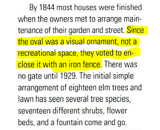
Since at least 1890, Louisburg Square has been owned not by its abutters (as tour guides will say, and abutters would have us believe), but by the City of Boston.
And yet, we hoi polloi are fenced out. Help me understand the legal (or corrupt) deal by which this came to be.
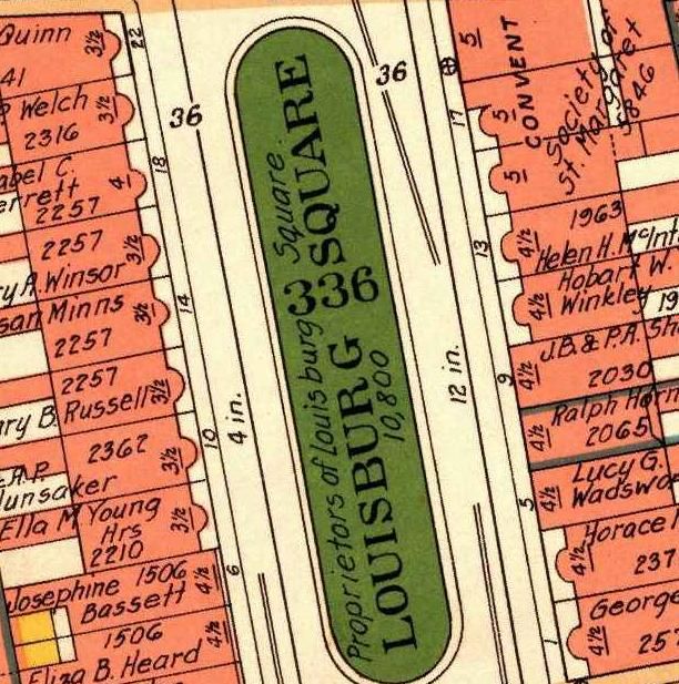
Start with the City Assessor, Ward 5, Block 336, Parcel 1717:
http://hubmaps1.cityofboston.gov/egis/Map.aspx?PropertyID=0501717000
See that? Owner:City Of Boston. 10,800 sq ft, worth $1,757,200 and which pays no property taxes. We the People own it. It's "property type" code is 985, which is "other exempt building"
So far, I've traced the City of Boston ownership back to 1890, as seen in both the "City of Boston" note in this 1890 map:
http://www.suffolkdeeds.com/images/cityproprox1890/0002.tif
And in subsequent "COB" notes in various maps, like the current Assessors maps: http://www.suffolkdeeds.com/images/boswardimages/ward 5/5012.tif
http://www.suffolkdeeds.com/images/boswardimages/ward 5/5014.tif
and even this City Parks document on page "5 5"
http://www.cityofboston.gov/parks/pdfs/os3b.pdf
But this is also where it starts to get strange. That document linked immediately above, even though the parcel is listed as COB-owned, goes on to map it (in the map at the end) as "private"
So too with this inventory of "private" and "unprotected" spaces in the city listing it as Private:
http://www.cityofboston.gov/parks/pdfs/OSP2010/OSP0814_5Tables_PrivUnprotOS.pdf
Maps from 1874 do not explicitly note it as City property (but are generally light on notes anyway). And yet the maps from 1874 do *lack* two key things:
http://www.suffolkdeeds.com/images/bos1874/0015.tif
http://www.suffolkdeeds.com/images/bos1874/0016.tif
Note that 1) no property lines are ever shown extending into the square (no "middle of the street / middle of the park" type boundaries) and 2) no owners name is shown (as on every other private parcel).
Can someone help me unknot this paradox? The winner gets a picnic or a just a nap in Louisburg Square.
My best guess is that somehow a deal was cut at some point deeding the land to the city but (at best) an easement back to the owners. But there's still something strange. The lot lines don't extend to the park's edge either (by what right to the abutters claim parking?). Seems like a deal cut in the mid 1800s basically, to keep the Brahmin happy and the Irish locked out--which was probably legal then but illegal now,perhaps analogous to covenants against selling to Jews and Blacks being unenforceable in this age.
And no regular citizens have noticed, and the abutters and the City have no interest in undoing a cozy deal. But it behooves citizens to know what that deal is.
Since at least 1890, Louisburg Square has been owned not by its abutters (as tour guides will say, and abutters would have us believe), but by the City of Boston.
And yet, we hoi polloi are fenced out. Help me understand the legal (or corrupt) deal by which this came to be.
Start with the City Assessor, Ward 5, Block 336, Parcel 1717:
http://hubmaps1.cityofboston.gov/egis/Map.aspx?PropertyID=0501717000
See that? Owner:City Of Boston. 10,800 sq ft, worth $1,757,200 and which pays no property taxes. We the People own it. It's "property type" code is 985, which is "other exempt building"
So far, I've traced the City of Boston ownership back to 1890, as seen in both the "City of Boston" note in this 1890 map:
http://www.suffolkdeeds.com/images/cityproprox1890/0002.tif
And in subsequent "COB" notes in various maps, like the current Assessors maps: http://www.suffolkdeeds.com/images/boswardimages/ward 5/5012.tif
http://www.suffolkdeeds.com/images/boswardimages/ward 5/5014.tif
and even this City Parks document on page "5 5"
http://www.cityofboston.gov/parks/pdfs/os3b.pdf
But this is also where it starts to get strange. That document linked immediately above, even though the parcel is listed as COB-owned, goes on to map it (in the map at the end) as "private"
So too with this inventory of "private" and "unprotected" spaces in the city listing it as Private:
http://www.cityofboston.gov/parks/pdfs/OSP2010/OSP0814_5Tables_PrivUnprotOS.pdf
Maps from 1874 do not explicitly note it as City property (but are generally light on notes anyway). And yet the maps from 1874 do *lack* two key things:
http://www.suffolkdeeds.com/images/bos1874/0015.tif
http://www.suffolkdeeds.com/images/bos1874/0016.tif
Note that 1) no property lines are ever shown extending into the square (no "middle of the street / middle of the park" type boundaries) and 2) no owners name is shown (as on every other private parcel).
Can someone help me unknot this paradox? The winner gets a picnic or a just a nap in Louisburg Square.
My best guess is that somehow a deal was cut at some point deeding the land to the city but (at best) an easement back to the owners. But there's still something strange. The lot lines don't extend to the park's edge either (by what right to the abutters claim parking?). Seems like a deal cut in the mid 1800s basically, to keep the Brahmin happy and the Irish locked out--which was probably legal then but illegal now,perhaps analogous to covenants against selling to Jews and Blacks being unenforceable in this age.
And no regular citizens have noticed, and the abutters and the City have no interest in undoing a cozy deal. But it behooves citizens to know what that deal is.
Last edited:
") )
)