Louisburg Square is City-Owned. How/Why "Private?"

Arlington

Moderator
Staff member
Joined
Dec 10, 2011
Messages
5,599
Reaction score
2,700
Louisburg Sq is City-Owned. How/Why "Private?"

Since at least 1890, Louisburg Square has been owned not by its abutters (as tour guides will say, and abutters would have us believe), but by the City of Boston.

And yet, we hoi polloi are fenced out. Help me understand the legal (or corrupt) deal by which this came to be.

Start with the City Assessor, Ward 5, Block 336, Parcel 1717:
http://hubmaps1.cityofboston.gov/egis/Map.aspx?PropertyID=0501717000

See that? Owner:City Of Boston. 10,800 sq ft, worth $1,757,200 and which pays no property taxes. We the People own it. It's "property type" code is 985, which is "other exempt building"

So far, I've traced the City of Boston ownership back to 1890, as seen in both the "City of Boston" note in this 1890 map:
http://www.suffolkdeeds.com/images/cityproprox1890/0002.tif

And in subsequent "COB" notes in various maps, like the current Assessors maps: http://www.suffolkdeeds.com/images/boswardimages/ward 5/5012.tif
http://www.suffolkdeeds.com/images/boswardimages/ward 5/5014.tif
and even this City Parks document on page "5 5"
http://www.cityofboston.gov/parks/pdfs/os3b.pdf

But this is also where it starts to get strange. That document linked immediately above, even though the parcel is listed as COB-owned, goes on to map it (in the map at the end) as "private"

So too with this inventory of "private" and "unprotected" spaces in the city listing it as Private:
http://www.cityofboston.gov/parks/pdfs/OSP2010/OSP0814_5Tables_PrivUnprotOS.pdf

Maps from 1874 do not explicitly note it as City property (but are generally light on notes anyway). And yet the maps from 1874 do *lack* two key things:
http://www.suffolkdeeds.com/images/bos1874/0015.tif
http://www.suffolkdeeds.com/images/bos1874/0016.tif
Note that 1) no property lines are ever shown extending into the square (no "middle of the street / middle of the park" type boundaries) and 2) no owners name is shown (as on every other private parcel).

Can someone help me unknot this paradox? The winner gets a picnic or a just a nap in Louisburg Square.

My best guess is that somehow a deal was cut at some point deeding the land to the city but (at best) an easement back to the owners. But there's still something strange. The lot lines don't extend to the park's edge either (by what right to the abutters claim parking?). Seems like a deal cut in the mid 1800s basically, to keep the Brahmin happy and the Irish locked out--which was probably legal then but illegal now,perhaps analogous to covenants against selling to Jews and Blacks being unenforceable in this age.

And no regular citizens have noticed, and the abutters and the City have no interest in undoing a cozy deal. But it behooves citizens to know what that deal is.
 
Last edited:
Well the streets are private ways, as far as I know. There are signs saying so. But there was that incident where Teresa Heinz wanted the fire hydrant moved a couple feet so she park her car, which implies that although it's a private way they are also set up to receive (and presumably pay for) city services.

Are you suggesting the residents up there are claiming squatters rights? After 25 years, the land is theirs if no one complains!

A bit of info on how the park is maintained; apparently Louisburg Square Proprietors pay into a fund, similar to a condo association.

louisburg_zpsa2e975d2.png


That doesn't shed any light on the ownership of the park, of course.
 
Last edited:
Are you suggesting the residents up there are claiming squatters rights? After 25 years, the land is theirs if no one complains!
Well, not quite. It just isn't clear at all what rights they're claiming and what rights they can rightly claim.

My first interest isn't so much the situation now or what kind of fight might happen in the future, but how we came to be here. How did "they" come to believe that it was in their power to gate the park in 1929? Before that, what deal happened between 1844 and 1890 such that it came to be recorded as City Owned?

On the one hand, the abutters (but only on the uphill and downhill sides) are claiming "enough" ownership to gate it, but on the other they've somehow been allowed to stop short of owning it "enough" to have to pay taxes.

I'm happy to see it tip all one way (a public park) or all the other (a private, tax-paying parcel). What seems wrong is the current public-ownership, private-use setup.

For it to be real Adverse Possession (ownership via squatting), though, their use has/had to be without the City's permission. If the City and they had a deal--but which is now void or revokable, they won't have a claim.

Part of the puzzle is what incentive the City would have had to take the property off the tax rolls and get nothing of public benefit in return.

Also, it would be interesting & helpful to know what corporate form "they" have. A corporation? A trust? An informal gang of neighbors?

Individual abutting owners with shared keys who came and went are unlikely to meet the test of "continuous use"--which is really meant for things like a structure accidentally put on the wrong side of a property line, or a parcel actually inhabited, or a path your livestock used every day...not just gazed at from across the street and only occasionally entered. If they really own the cobblestone street, the fence is just an ordinary property line. Perhaps the claim is more that for the City to enter its park, it must *cross* "their" parcel--something they forbid?

A bit of info on how the park is maintained; apparently Louisburg Square Proprietors pay into a fund, similar to a condo association
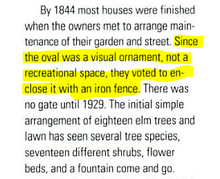
By 1844 most houses were finished when the owners met to arrange maintenance of their garden and street. Since the oval was a visual ornament, not a recreational space, they voted to enclose it with an iron fence There was no gate until 1929. The initial simple arrangement of eighteen elem trees and lawn has seen several tree species, seventeen different shrubs, flower beds, and a fountain come and go
That doesn't shed any light on the ownership of the park, of course.
What is the source of your image (which, for posterity, I have retyped here). Is there any more? While the neighbors may have had "their garden" in 1844, they'd deeded it to the City by 1890. And then who installed the gate in 1929 and by what right? Also, at about 1929, I'm sure parking (in a rich neighborhood) would have started to get tight (not quite as tight as when the Kerrys and Heinzes moved in together, but getting there).
 
Last edited:
I believe Union Park and Worcester Square in the South End have similar arrangements, where only abutters have keys?
 
I believe Union Park and Worcester Square in the South End have similar arrangements, where only abutters have keys?
They seem similar but different.

The three South End parks are all listed as owned by "Parks" and mapped in green in the City's Open Space Plan http://www.cityofboston.gov/parks/pdfs/os3n.pdf

Louisburg Square, by contrast, is listed in its plan as owned by "COB" (City of Boston) and is mapped in grey--the same color as, for example, Prudential Plaza and the Christian Science Plaza (which, though clearly "private" are *far* more accessible than Louisburg)

I did find this History of Union Park (which asserts many similarities to Louisburg Square) to be helpful. http://upna.org/files/HistoryofUnionPark.pdf

The problem I find with these stories (especially the one above) is that they're all told from the keyholder or wannabe's perspective--about how much control the neighbors were asserting and the fences they were building--but not the part where the neighbors might run out of money or will and deed the things to the City.

Here are some abbreviations you'll see in the documents
COB City of Boston
COB/BRA Boston Redev. Auth.
COM Commonwealth of Mass
MDC (now DCR...Dept of Rec. and Conservation)

And here are some I'm introducing for this thread
LS Louisburg Square
WS Worcester Square
UP Union Park
CP Chester Park
 
My problem is that I just can't see a City lawyer and a Neighborhood lawyer sitting down and writing a deal that says:
"City shall own the title to the land and the neighbors shall maintain it for their exclusive use and enjoyment."

Its that "exclusive" part...the right to exclude...if you're the City, isn't the obvious deal more along the lines of:
"City shall own the title to the land and the neighbors shall maintain it for public use and enjoyment"

(ie be obligated to open it, in exactly the "natural" way that the Pru and Christian Science Plazas were/are)
 
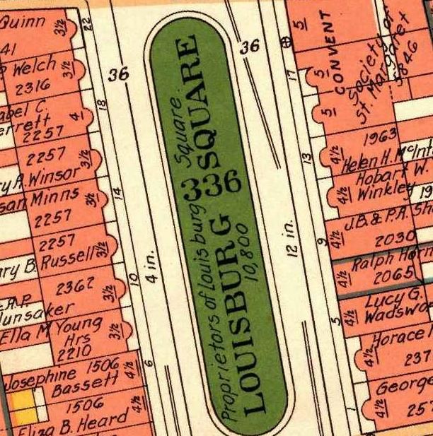
The 1938 Bromley atlas map shows it Proprietors of Louisburg Square


lburgsq1938_zpsb915785f.jpg
 
"For it to be real Adverse Possession (ownership via squatting), though, their use has/had to be without the City's permission. If the City and they had a deal--but which is now void or revokable, they won't have a claim."

Sorry. No adverse possession against the sovereign (unless the sovereign acquires a property that is already the subject of 20 years open and notorious possession by a squatter.)
 
^^ I was going to chime in with that as the annoying 1L in the middle of property class. Incidentally, my property casebook does note an interesting exception to the common law rule that adverse possession doesn't run against the state. That is, some states apparently permit AP "only against government lands held in a proprietary (as opposed to a public or governmental) capacity."

It cites a New Jersey case involving "municipally-owned property not dedicated to or used for a public purpose." The court held that such property can be adversely possessed!

Now, I thought I might be on to something here, so I started scrolling through the opinion on Westlaw...until I got to this:

"Massachusetts permits no adverse possession of State land "held for conservation, open space, parks, recreation, water protection, wildlife protection, or other public purpose." Mass. Gen. L. ch. 260, § 31 (1984)"

*shrug*
 
The Union Park situation is different. The abutters do whatever they can to perpetuate the myth that the park is private. There was a TV news story about this several years ago. They lock it illegally. They open it on "special occasions", they say, which basically means when they damn well please.

This was a "first-hand" conversation I had with one of the Union Park Neighborhood Association members, by email.
 
The Union Park situation is different. The abutters do whatever they can to perpetuate the myth that the park is private. There was a TV news story about this several years ago. They lock it illegally. They open it on "special occasions", they say, which basically means when they damn well please.

This is accurate and the entitlement is part the issue surrounding the abutters paying for restoration work of the park. The fencing and fountain upkeep has been a pissing contest for a very long time.
 
^^ I was going to chime in with that as the annoying 1L in the middle of property class. Incidentally, my property casebook does note an interesting exception to the common law rule that adverse possession doesn't run against the state. That is, some states apparently permit AP "only against government lands held in a proprietary (as opposed to a public or governmental) capacity."

It cites a New Jersey case involving "municipally-owned property not dedicated to or used for a public purpose." The court held that such property can be adversely possessed!

Now, I thought I might be on to something here, so I started scrolling through the opinion on Westlaw...until I got to this:

"Massachusetts permits no adverse possession of State land "held for conservation, open space, parks, recreation, water protection, wildlife protection, or other public purpose." Mass. Gen. L. ch. 260, § 31 (1984)"

*shrug*


The New Jersey precedent you cite is interesting and logical. There is an analog in state tort law, where the Mass Tort Claims Act imposes a $100,000 cap for actions against the sovereign when it performs a governmental function. There is no cap for non-governmental functions, for example, a tort claim that might arise from drinking at a bar at a municipally owned golf course (the theory being that serving alcohol is not a governmental function.)

Good luck with law school. The first year is the most interesting, the last is just the fruit of the law professor full employment act.
 
Thanks everyone! Here's where we are so far:

TIMELINE
c. 1844 The Proprietors of Louisburg Square probably originated the park. (But no records of such an organization can be found at a Mass Sec of State online search[1])
c. 1848 Louisburg Square is enlarged and fenced (but not gated, we believe)
c. 1874 Property mapped, no owner shown
c. 1890 Property mapped, City of Boston shown as owner
c. 1929 A gate is installed
c. 1938 Bromley maps ownership to The Proprietors of Louisburg Square (I personally believe this is an error)
Current: Owner is City of Boston

LEGAL POINTS
- Whatever rights the neighbors have, they likely did not accrue through adverse possession and current Mass policy on adverse possession forbids it against the sovereign (the City, in this case)
- While confused in the past, the present tax situation is very clear: the land is owned by the City
- The City seems confused/conflicted as to its claim to and power over Louisburg Square
- The Union Park Neighborhood Assn is believed to lock their park illegally, and partly pattern their history and their claims on Louisburg Square.

INFERENCE BY ME
My gut tells me that the neighbors on Louisburg Sq have been slowly and cumulatively been illegally blocking access--and that, as a body, they are much more motivated in asserting their claims (just like the UPNA.org is) than the City is in fighting them off.

My gut is people, over time, forgot that parks were fenced for reasons unrelated to ownership. Parks in the 1800s had fences. It was the style: Cast iron was a supremely artistic, durable and fashionable ornament when the industrial age introduced it as a building material (much better than brick or stone or wood and predating steel and galvanization). You made fences and fountains out of cast iron because it was "a la mode"--like studding ante-bellum New Orleans with cast iron porches-- not because you were the proprietor.

And they forgot the practical role of a park fence (anti-horse, anti-footpath) and by 1929 (with "bums" and "hobos" and autos infesting the city) started thinking: a fence needs a gate, a gate needs a lock, a lock needs a proprietor, ergo its mine.

[1] I find it significant that Proprietors of Louisburg Square cannot be found via search at The Sec of State's corporation search. The Secretary has plenty of old proprietor corporations, like the Proprietors of the Cemetary at Mt Auburn from 1835 and the Proprietors of the Boston Athenaeum from 1807. Age and nonprofit status aren't a problem here.
 
Last edited:
Here are a few thoughts on this. Fun post.

John is indeed right that Louisburg Square is a private way. The city street book lists it as extending from 89 Mt. Vernon to 78 Pinckney (and spelled "Louisbourg," the earlier variation). Now, if you look at those two addresses on a city map, you'll see that those two lot lines abut the homes on the eastern edge of the square today. If we were to go back into the history of the square, would we find that the whole thing -- west homes, west street side, park, east street side, east homes -- traced back to a common owner? That's one explanation for why private lot lines don't extend into the streets: perhaps the private lots were carved out from the larger parcel, and the rest became a private way by default. Maybe worth going back to earlier plans to find out. The simpler explanation is that abutters of a private way are responsible for its upkeep and receive statutory easements for the placement of non-obstructive utilities through such ways; thus, a private way is "owned" by its abutters for practical purposes. (As an aside, Union Park is listed in the street book as a public way.)

So Louisburg Square is a private way, and a wide one at that, but the island in the middle appears city-owned. I couldn't find details of the transfer to the City online -- it looks like somebody would have to dig through the grantor/grantee index at the Registry of Deeds for that, or possibly check with City Assessing to find out when the tax parcel was created. But I could use the online database to find a 1944 agreement by and among the semi-shadowy "Proprietors of Louisburg Square." If you go here, set your search criteria to "Unindexed Property" on the Recorded Land side, and search book 6089, you'll find the agreement starting on page 121. I'm not provisioned to screencap, so I'll type out the beginning part:

We, the undersigned, being the owners of the estates facing Louisburg Square, in Boston, Suffolk County, Massachusetts, indicated opposite our respective signatures hereto, for ourselves and our successors in title as owners of said estates, hereby mutually COVENANT and AGREE as follows: (1) The central portion of said Square, now enclosed by a fence, shall be controlled as to use, maintenance and repairs by a committee selected, as hereinafter provided, by and from persons owning an interest in one or more of said estates and their spouses; and the fence, narrow sidewalk and roadways surrounding said Square shall be controlled as to maintenance and repairs by said Committee. In addition, said Committee may take all reasonable action to prevent the use of said roadways by persons other than said owners and their guests . . . .

This agreement remained in effect as recently as 1988, when it was amended to add indemnification language for any member of the Committee acting lawfully to further the Committee's ends (book/page: 14425/177). My guess is that it's still in force today. So that should give us a pretty good idea of why Louisburg Square owners think they can exclude the general public from the streets: because they very likely can.

Two questions raised but not answered:

1. Does the general public have the right to access City land that happens to be surrounded by private land from which the public can be excluded? If you imagine that the lot isn't a leafy park, but rather a maintenance facility or a tow lot, then you'd probably say "no" pretty quickly. And if the City hasn't designated the land as a park, as posts above seem to indicate, then all the less reason for the public to have access -- acknowledging, of course, that this position requires a firm belief in the power of semantics.

2. What rights did the City gain if/when it assumed ownership of the center park? By the terms of the agreement above, the abutters are responsible for maintenance, so the City doesn't even need access to mow the lawn. There don't appear to be any utilities on or beneath the park (correct me if I'm wrong), so the City doesn't need an easement to access it for those reasons. And the last couple centuries of exclusivity have made it clear that the City doesn't think it acquired a public park. What did the City get that's worth putting its name on this parcel? Note also that the City assessing database doesn't always list the fee owner of the parcel. Take this one for example, which shows the entity that pays the taxes on Faneuil Hall Marketplace as part of its 99-year lease agreement with the BRA.

And this brings me quite neatly to a different inference, Arlington. It appears likelier to me that the land was always private, and that the city got involved with the center island in the mid-to-late-1800s, perhaps to give a break to well-connected abutters whose private way was starting to take on the appearance of developed and taxable property. If so, it's not the access we should be upset about -- we the People may have never been entitled that. It's the taxes, and not a little bit of privilege, that should burn us up, same as ever.
 
Last edited:
So Louisburg Square is a private way, and a wide one at that, but the island in the middle appears city-owned. I couldn't find details of the transfer to the City online -- it looks like somebody would have to dig through the grantor/grantee index at the Registry of Deeds for that, or possibly check with City Assessing to find out when the tax parcel was created. But I could use the online database to find a 1944 agreement by and among the semi-shadowy "Proprietors of Louisburg Square." If you go here, set your search criteria to "Unindexed Property" on the Recorded Land side, and search book 6089, you'll find the agreement starting on page 121. I'm not provisioned to screencap, so I'll type out the beginning part:

This agreement remained in effect as recently as 1988, when it was amended to add indemnification language for any member of the Committee acting lawfully to further the Committee's ends (book/page: 14425/177). My guess is that it's still in force today. So that should give us a pretty good idea of why Louisburg Square owners think they can exclude the general public from the streets: because they very likely can.

Thanks so much for doing this! I am very grateful to have elicited exactly the best sort of expertise and careful research that ArchBoston can provide.

Having read the deal online, I'm still a little suspicious of a contract that appears to bind only abutters and not the city. It may only prove that the neighbors have mutually-mystified each other and are trying their best to reclaim some lost mantle. (Remind me sometime to record a deal I cut with my neighbors for control of the Mass Pike. We tried to be fair in revenue allocation. We divide it among ourselves pro-rata by feet of street frontage ;) )

As noted earlier, I'm happy to conclude either that it is a public park (as I infer) or that they should be paying taxes (as you infer), but not that we should be left in this limbo where the private owners have sloughed their tax burden onto the city for their own private enjoyment.
 
Is there someplace one can research the history/transfers/deeds by block number? The block in this case is # 336 (it has only one parcel--#1717, Louisburg Square)

Block 335 (downhill)
Block 336 (fenced garden)
Block 337 (uphill)

Also here is a piece which fully relates the Proprietor's side of the story, except for the part where the City pays the taxes:
http://books.google.com/books?id=EwO8sFfSe8sC&pg=PA39&lpg=PA45&dq=Louisburg+Square
 
City doesn't pay taxes to itself.

I've found that municipal tax records are not always what they seem, the name and address on the tax bill may be the entity responsible for paying the taxes, not the entity actually owning the property. Leaseholds particularly come to mind.

And for a long period during the 20th Century, much of one side of the square (including the Kerry-Heinz abode) was owned by the Episcopal church, it was the convent of the Sisters of St. Margaret. One can suspect that arrangements were perhaps made during this period for the city to assume some responsibility for maintaining the square.
 
Is there someplace one can research the history/transfers/deeds by block number? The block in this case is # 336 (it has only one parcel--#1717, Louisburg Square)

The only place I know for this is City Assessing. From the plaza entrance to City Hall, take a left after the security checkpoint and then a right before the escalators. Assessing is the door at the end of the hall. There's a desk on the left side of the room where you can ask for binders (organized by ward) that contain microfilm of the cards that they used before the system went to computer. So for this one you'd ask for Ward 5 and see if the binder has the card you're looking for, #1717 (many have gone missing, unfortunately). There's a microfilm reader and printer in the room, and I believe there's a nominal charge for printing, which you probably wouldn't need to do anyway if you were only looking up one parcel.

The cards are two sided, and both sides might have some book/page numbers for the Suffolk Registry of Deeds. The front may have a plan that shows the parcel; based on the current assessor map linked up at the top, this card will probably list book 312, plan 217, which shows the layout of the square as of 1826 (again, sorry for no screencapping, but maybe somebody could grab that off masslandrecords.com). The front may also have some early transfer info, but that information generally belongs on the back of the card. For this parcel the transfer probably happened too early to be recorded on the card. The cards for more recently created parcels, like for subdivisions or road shifts, will also tell you when the tax parcel was created by fiscal year and from which former parcel, so that you can look back to a predecessor if need be.

I may be in the area this week and I will take a couple minutes to check it out if I am.
 
Sorry. No adverse possession against the sovereign (unless the sovereign acquires a property that is already the subject of 20 years open and notorious possession by a squatter.)

Nope. Go up to Land Court and you'll find plenty of adverse possession cases against municipalities, usually for properties in tax possession that the municipality either didn't know were in its inventory or abandoned. There is, however (regardless of owner), no adverse possession against registered land (property with Certificate of Title with an attached memoranda of encumbrances), title of which is guaranteed by the Commonwealth, as opposed to recorded land (property in which encumbrances on title is recorded in various books and pages)
 
City doesn't pay taxes to itself.

I've found that municipal tax records are not always what they seem, the name and address on the tax bill may be the entity responsible for paying the taxes, not the entity actually owning the property. Leaseholds particularly come to mind.
I'm not sure of your point. You seem to be saying:
1) Tax records aren't perfect: fee ownership can be masked by leaseholders because the tax records favor listing the tax-payer as the "owner".
2) The City is like other owners in having its ownership masked sometimes (as at Faneuil Hall Marketplace)
3) But The City will never mask the ownership of others (if the City is listed as owner, it *is* the owner because it would always prefer to list someone else)
4)Therefore, if the tax records show City of Boston as the owner of Louisburg Square, it likely is the owner because it would have listed some tax payer if it could have

Have I interpreted you correctly?

At the same time, when it lists a property as exempt, does it sometimes list itself as "owner" in the tax records just to save everyone the trouble of mistakenly trying to collect?
 

Back
Top