Federal Funds for South Station Expansion

Where the fuck is Amtrak in all of this? I understand they're a little timid with the fallout from derailment and laying low until the next bout of "how else can we fuck it up" transpo funding negotiations.

Yet, this is their project, just as much as it's ours. SSX gets Amtrak hourly Acelas, some NER backfill, some Inland Route backfill which, with amped-up CT River valley CR and improved Vermonter/Montreal service, gets Springfield a whole lot of connections. Now, Foxx obviously can't stroll on down to the USPS on our behalf and bust some heads, but would that be anymore bizarre a situation than one Federal agency paying to be stonewalled by another.

Gateway is going to be a fight and it's going to get so, so much more ugly than it is currently - I would think Amtrak would be in the market for a slam-dunk, isn't going to fail miserably sort of project that SSX offers. The air rights alone - both the max/min builds over the 7 new tracks and the Hines rights over the terminal building - secure the Feds to an extent, even if they fuck-up (which they won't) or their best laid plans go through the meat-grinder (which hopefully won't happen), the real estate considerations and benefits here are immense - something good is bound to happen, for both Mass and Amtrak.
 
Last edited:
^ Yeah it's amazing (but not surprising) that the lose-lose-lose status quo is persisting despite so many plausible win-win-win scenarios ...

Does there even need to be a full transfer of ownership? Couldn't USPS take an equity (or pseudo-equity) stake in the revenue stream from the air rights, while giving the rail agencies the ability to build via a 99-year lease, JV, special vehicle, etc.? AFAIK many of their problematic liabilities are long-term, so you'd think they'd have a huge appetite for buying into a long-term asset like this, especially if they could squeeze some recurring cash flow from it.

Unless it's a mark-to-mark issue wrt to their balance sheet (assuming they even use one).

Makes you wonder if the some of the folks holding the purse strings actually want our public institution to struggle and/or fail, but that kind of irresponsibility surely wouldn't be tolerated .... yeah, forget it..............
 
The VP of facilities for USPS responded to the Globe's recent spate of articles / editorials with a letter to the editor:

http://www.bostonglobe.com/opinion/...-point-site/x1i19FkGl4sT9Gq36tvmqO/story.html

Sample quote:

In early 2011, the Postal Service and MassDOT signed a memorandum of understanding regarding the transaction. The memorandum was the product of negotiations between the parties, and reflects terms to which the Postal Service and MassDOT mutually agreed. The memorandum represents a fair approach for all interested stakeholders.

The Postal Service continues to be interested in honoring the original arrangement, which would allow the project to move forward rapidly for the benefit of all involved.
 
So I understand that a great deal of the cost of NSRL is the run-in to south station with approaches and tunnels but let me throw this out:
As a Phase 1 of NSRL and a component of SSX which would be needed with or without NSRL. Would it be plausible to build the approaches to South Station from Fairmount/NEC and stub-end them below South Station with the intent of extending later?
You could then
1. Put dedicated Amtrak platforms there or
2. Run electric service on the NEC commuter lines or
3. Electrify the Fairmount line, dispatch with the DMU and go to EMU. Have access to the New Indigo Line directly from the Red Line/Silver Line Concourse and assure easy transfers.

I like how you think, but I suspect that once you've procured and launched a Tunnel Boring Machine it is cheaper just to keep it going than to stop short at South Station Under (or if they choose some other method of coring out the space left for the NSRL, they need an easy way to haul out the fill, with the most logical place being to take it out the first portal)

I don't think this saves as much money as you'd hope given the need for launch boxes and extraction pits for machines and fill. I suspect 2 TBMs would get launched from the NS and SS ends and get extracted from the pit where they meet at Aquarium or they pass each other and each do a full length bore North<-->South
 
I don't think this saves as much money as you'd hope given the need for launch boxes and extraction pits for machines and fill. I suspect 2 TBMs would get launched from the NS and SS ends and get extracted from the pit where they meet at Aquarium or they pass each other and each do a full length bore North<-->South

And many TBM are just left in place at the end of the run, some distance past where the tunnel rises to a portal (often cheaper than extracting them -- they are often basically all used up).
 
OK - so if anyone really does an appetite for another run around the tree on NSRL...

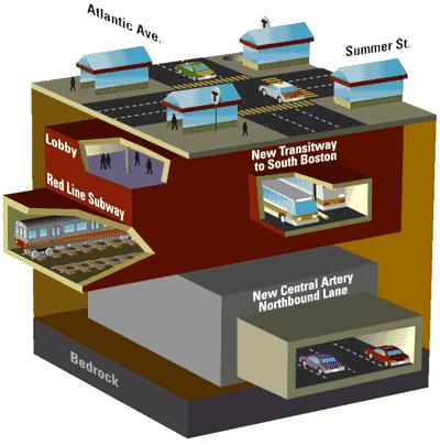
Is there REALLY no plausible alternative to the Central Artery routing? Here's why I'm hungry to dream up / revisit alternatives:

1. It just seems so unlikely that putting the mode with the least vertical flexibility at the BOTTOM of the city is the right way to go ... we all know a lot of the cost is portals, and you're still stuck with steep non-standard grades on both ends. Meanwhile, there's a big hill in the middle of the peninsula (you'd probably noticed) and 'as the crow flies' you could (...theoretically, for rhetorical effect...) even get from South to North with barely any incline at all, while still finding yourself 50 feet below grade and 10 feet above high tide at the midway point. Going all the way to the bottom of the O'neill just seems ... masochistic.

2. Clean fill /= smooth sailing. As I understand it (many thanks as always, F-line) the space between the slurry walls at the bottom of the CA tunnel was backfilled with clean, uniform dirt (I picture a line of sandhogs with pushbrooms exposing the bedrock to the sky to complete the excavation phase sometime in the mid nineties, but that's probably not entirely accurate). So no 'Bertha-esque' surprises, in theory (but really, would we be shocked if there were still a Gradall or a couple Bobcats down there?). But you're still messing with a megastructure that's not exactly shown itself to be robust and resilient. Do we really want to find out how big the 'cavity' below the fort point tunnel can get? Do we want to apply a couple years of TBM-level vibration to the slurry walls downtown and see what happens?

3. There doesn't seem to be a lot of 'bonus functionality' to be extracted, beyond the rail link. The link itself should be compelling, of course, but if we looked at any list of the OTHER top transit to-dos....red/blue, park street rehab, green-eats silver, etc....the artery routing doesn't get you much closer to them (maybe green-silver, but that's it). No one is asking for Central Station, and the 'Red X' and other ideas that we've floated here seem a little byzantine at this point. Yes NSRL opens up GJ transit, two-seat to the seaport from across the region, etc....but none of those are particular to the artery ROUTING. While other routings might at least potentially open up new possibilities (e.g. GL to SS via PO Sq; blue/red or blue/north, etc.)

So...anyone have ideas on what's the second-best routing? Why did Congress St. get nixed - and is it still possible to get traintracks across the artery E-W below grade between Rowes Wharf and Dewey Sq., without going all the way down?

And when does it become rational to re-route / re-purpose the the Dewey Sq. Silver line tunnel to make more space available closer to the surface in that neck of the woods?

What if you give yourself permission to take down commercial buildings? e.g. if we had to raze the low-rise portion of the Fed, would that be a bug or a feature? And there's a cluster of old buildings between Congress and Pearl that will probably get McMansioned in the next decade anyway - are those sacrosanct? (I'm thinking especially of all the engineering and cash that went into getting the SL under Russia Wharf, less than a decade before the latter was fully facendectomied anyway...

Alternatively - Commercial St. and Atlantic Ave. (excluding 'old Atlantic Ave' which is now below the Marriott Starbucks and the Harbor Garage) are wide and unclaimed?

Again - not my intention to resurrect a dead horse just for the purposes of beating it some more - but at $8bn for a functional mile or whatever, and given the complications listed above, I think we owe it to ourselves to keep a close eye on the 'second best option'.

I mean, for $8B you might as well re-route 93S through the MBTA lobby and above 93N on Atlantic Ave, and put three tracks through one side of the old Dewey Sq. Tunnel, for crying out loud (...rhetorical...)
 
Any routing that goes under Congress is going to have to dive under the CAT anyway, so the southern portal expense is going to be exactly the same. At North Station, the link needs to stay low to avoid the green and orange lines, making it doubtful that the northern portal could be south of the Charles, requiring the north portals expense to be the same as the CAT routing. It just doesn't seem easier or cheaper.
 
I've thought of a "better" routing, but I highly doubt it would be cheaper.

Here's the short version, without the technical details: Cut and cover from Back Bay to West St via Columbus Ave and the Columbus Mall in Boston Common. Cut and cover inside of the Green Line tunnel all the way to North Station. Center Station would be 1000' platforms stretching from Park St Station to Government Center Station, giving access to all four MBTA lines, creating a true super-station in a central location with maximized walk-shed.

It would be two levels below surface at a minimum at all times. At Park St and Government Center it would actually be the third level down. Hopefully this will mean that a majority of utilities can be worked around while cut-and-covering, instead of being outright relocated.

South Station would continue to serve non-thru routes and most/all Old Colony service.
 
Since we've gone to the realm of crazy transit pitches I'll add my own which I've considered for a while. (And while insane, it may, be cheaper than UrbEx's idea)

Simply put: CR eats OL downtown to North Station with a downtown station at DTX. In a "swapsie" the OL then eats CR to South Station (under), excavate new (but pre-cleared and slurry-walled) tunnel to North Station. New OL stations at Tremont St and Ink Block along former CR tracks (replacing Chinatown and TMC) and new station/connection at Aquarium along the Greenway.

Pros: no need for expensive SS CR approaches. No need for SS expansion, probably. New rapid transit corridor along the Greenway. Huge walking/transit catchment area downtown for new Central Station at DTX.

Cons: rather insane?

Even Crazier: branch the new OL routing into the SL tunnel - you know you want that Seaport / BBY connection!
 
Solid - but both of those would have to face the question of how to get across the pike.

Mine - if congress is off the table - is just to stay east of the artery the whole way through, staying above the red line and then staying as close to the surface as possible.

...Because my intuition is that the biggest bundle of cost savings available from alternate routings would come from starting the southern portal(s) within the existing footprint of the SS tail tracks - i.e. north of the fort point pike tunnel, once the tracks have already crossed it on the surface. You'd likely still need 2-3 southern portals to make the crossovers work efficiently, but they could merge very quickly within the SS footprint, and you'd save a LOT of complicated digging, and you don't have to mess with the south cove muck, mud and mess.

But if you do that, you're more or less compelled to go over the Red Line at Summer St, and also over the SL behind the intercontinental. So at that point, the routing would have to go via the waterside of the Rowes Wharf 'piers' as well. After that I think you can bring it back to 'dry land' in front of the aquarium at Long Wharf (squeezing between the IMAX and the seal tank and then under the Marriott, maybe with some acceptable collateral demolition / reconstruction to the adjacent structures), and then continue up Atlantic and Commercial, with ample of clearance over the BL and original harbor tunnels (and some good underpinning). Then out into the head of the Charles where that skating rink is, and via the water side of Lovejoy right through the state police boat dock to a platform under the NS surface tracks, at something like a 45% degree angle to the existing track layout above, and onward to a north portal that would look a lot like it would under the status quo.

You could cut and cover the whole thing, nearly, with a few submerged tube segments near rowes wharf and on either side of the Charles River Dam.

Bonus points - the piers in front of the Harbor Towers and the Aquarium historically went further into the harbor, so there's an opportunity to create some terra firma there, either for engineering purposes or for real estate reasons.

Also, if the geometry says you have to go through the space occupied by the SL tunnel behind the Intercon, you can just plow right through, and replace it with a parallel extension for the SL up the east side of SS under dot ave (with the existing segment in front of the fed thereby becoming defunct) - now that Essex st is off the table, that's not a fatal re-routing. And if you can save a meaningful fraction of $8B, that's worth the price of the creative destruction.

Feasible?
 
I have a crazy one: four-track takes the CA/T from the Pike/93 Interchange to North Station. Minimal additional tunneling needed. Then, eliminate the Northern Expressway, all the way to 128, and replace it with a surface boulevard with transit.
 
^Love it. With $4B leftover for tram-ification of key surface roads. It's never too late for the Amsterdam option!
 
Lets move the crazy pitches to that thread. All I was asking was for Mass to show the USPS that it had sufficient alternatives that the USPS couldnt just extort, but would have to craft/negotiate at South Station.
 
Lets move the crazy pitches to that thread. All I was asking was for Mass to show the USPS that it had sufficient alternatives that the USPS couldnt just extort, but would have to craft/negotiate at South Station.

So if the extorsion from the USPS is bad enough, isn't one of the alternatives to two-level the South Station Platforms. Probably segregate by where you are feeding from (south or west).

Certainily expensive development, but at some point the USPS drives you to an expensive alternative.
 
OK, so if anything going under South Station is billions and the USPS holds out, could you go up?
Google maps shows 1200 feet from the bus ramp to the channel on the the Old Colony side. Could you use old technology to elevate 4 tracks or so starting in the various rail yards and bring them as close to the station as possible? Put in a new stairway/bridge near bus station at Kneeland/Atlantic for those passengers? Guessing that would bring down cost by a couple orders of magnitude while providing good congestion relief.

There is nothing (but cost) to prevent you from going UNDER the current tracks for another level. The Bus Station had to straddle the tracks, so you know where those footers are.

Basically create a near duplicate platform "under". Complex construction -- sure. But make it as a threat to the USPS (we don't really need you!). Many stations in Europe are dual level like that.

Would that even be possible? I thought the Silver Line tunnel took up the original "South Station Under" area.
 
Nope - lobby is under summer / atlantic intersection; turnaround is under atlantic, tunnel goes in front of the fed and then under atlantic wharf:

gwred04.jpg


South%20Station%20Neighborhood%20Map%20tn.png


1698.jpg


http://www.dr-sauer.com/projects/mbta-russia-wharf-segment-section-cc03a
 
Last edited:

Back
Top