I've been less intensively following bike projects (biking less too) the past year and a half, sadly.. so Im out of the loop, but was pleased when I googled around any news of the Northern Strand trail -
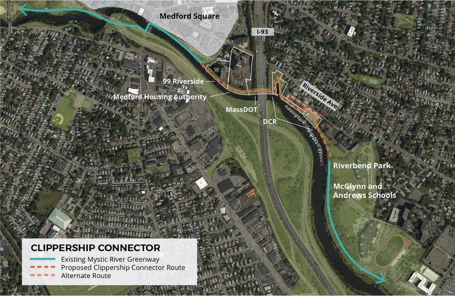
There's a new mayor in Lynn who supports it (the old troglodyte one had opposed building the path thru Lynn), and the state is going to pay for a paved path all the way from Everett to Lynn. The city is now trying to figure out how to get it connected from where the rail line ends at the MBTA tracks, across, and to the shore. I don't know how long this all will take but it's major progress and sounds like, from what I read, pretty much a done deal. This will be a pretty major trail once it's actually paved - the crushed asphalt parts are pretty uncomfortable to ride on unless you have a mountain bike - and there will be opportunities for connection, hopefully and eventually, to Medford's trails as well. Lynn also is close to Swampscott, so with the Swampscott extension of the Marblehhead trail, it wouldn't take too much improvements on the Lynn roads to get a pretty good connection between those two trails, too.
 lane'' and ``bike
  lane'' (and the emoji I'm getting for those shouldn't be copied too literally; I'm getting a school bus and not a transit bus). (I think Connecticut requires cars to stay at least 3' away from bikes, which is why I think excluding bikes from the left 3' of the bus lane may be appropriate, and 3' on the right is to keep bikes out of the door zone of the parked cars.)