Biking the Boston 'Burbs (Trails, MDC, & Towns beyond Hubway area)

"Derelict stairs"... thats fuckin awesome and prompted some googling... Is this brick ruin the remains of the old station?

Chatham St.: those are the stairs to East Lynn station. Pretty certain it was just platform access and shelter only, as that that adjacent brick structure appears to be a property wall around a backyard and not a former building foundation. Old Historic Aerials topos don't show any building there so it was probably always just a backyard that eventually got ringed with brick because there was no street access that close to the viaduct to plunk another triple-decker. Also inconceivable that the Eastern RR would've built a station structure on such a huge adjoining parcel when E. Lynn was such a minor spacer stop; Swampscott Depot much more fit the mold for vintage ERR construction outside of the biggest dead-center downtown stops of Lynn + Salem.

Do note the 2 empty track berths on the bridge abutments removed during the last deck replacement. This structure too is Blue Line-ready if they want to start thinking second-wave extension north to Swampscott and Salem, only needing a replacement outer pair of decks slapped down to quad back up (like Eastern Ave. is on the next bridge north to Swampscott).


Here on Commercial St. are the stairs for West Lynn station, with the extra concrete cliff by the 4-deck overpass marking where the old northbound platform was. As you can see there's no real way to finagle trail access here despite proximity a mere 500 ft. away from the old junction with the Saugus Branch. You'd have to raze Igor's Auto Body to create any sort of ramp grading that would pass accessibility muster. The Eastern went cheap and steep when it did its mass grade separation of the Lynn-Swampscott street grid.

W. Lynn could very well host a Blue Line station someday as an intermediate between River Works/Lynnport and Central Square (the only two candidates thus far officially spitballed for BLX on that side of the river). Commercial's the straightest shot to Market Square to the north and commercial redev of the emptiest/ripest slab of waterfront to the south...plus the auto chop shops surrounding the station site make for a good TOD cleanrooming canvas. And if you use average Eastie-Revere BL station spacing as a measuring stick, the 1.6 mile station spacing between RW and CS in a pretty dense part of the city ends up awfully off-scale vs. the rest of the line and starts begging for another spacer (esp. with 2 and 4 different bus routes respectively at each end of the block). Riverworks-W. Lynn and W. Lynn-Central Square would slot at roughly Beachmont-Revere Beach equivalent for station spacing...still at the longer end of average for the current BL. Food for thought. . .
 
Last edited:
That brick structure appears to have been a B&M engine house. The station itself was on the east side of Chatham, north of the tracks - see the stairs here. The stairs south of the tracks on the east side may have served a northbound platform.

The East Lynn station was a rather impressive stone structure. It actually still exists - it was moved to Durham, where it is now the Amtrak station and the UNH dairy bar.
 
Fantastic information. Amazing re E Lynn Station. Thank you both.
 
Still maddening that MassDOT refuses to pay CSX's asking price for the South Sudbury Depot-Framingham segment. 10 years of forcing the towns to go it alone has proven that there'll never be enough spare municipal budgets to close the sale without any state assistance. What are they waiting for?
 
Not sure how they'd ever maneuver it close to the Marblehead Branch trail. There isn't a mechanism for a direct connection any which way. But I suppose if you cycle-tracked up the length of Lynn Shore Dr. it's then only a 6 or 7 block gap up Monument Ave./Walker Rd. to the Marblehead trail...which probably has to terminate @ Walker because of missing overpass decks at 1A and Stetson Ave. Walker's narrow and a little winding but not all that high-traffic, so wayfinding stripeage may have to suffice. The Marblehead Branch does have pretty excellent grade separation going for it once you get there, crossing mostly very quiet residential streets. So if they can finagle "good enough" wayfinding on that slightly less than half-mile between beach and trail it's smooth sailing the remaining 3.5 miles to downtown Marblehead.

Could Walker be converted to a one way street, with whichever lane becomes no longer for automobiles being converted to a bidirectional cycle track?
 
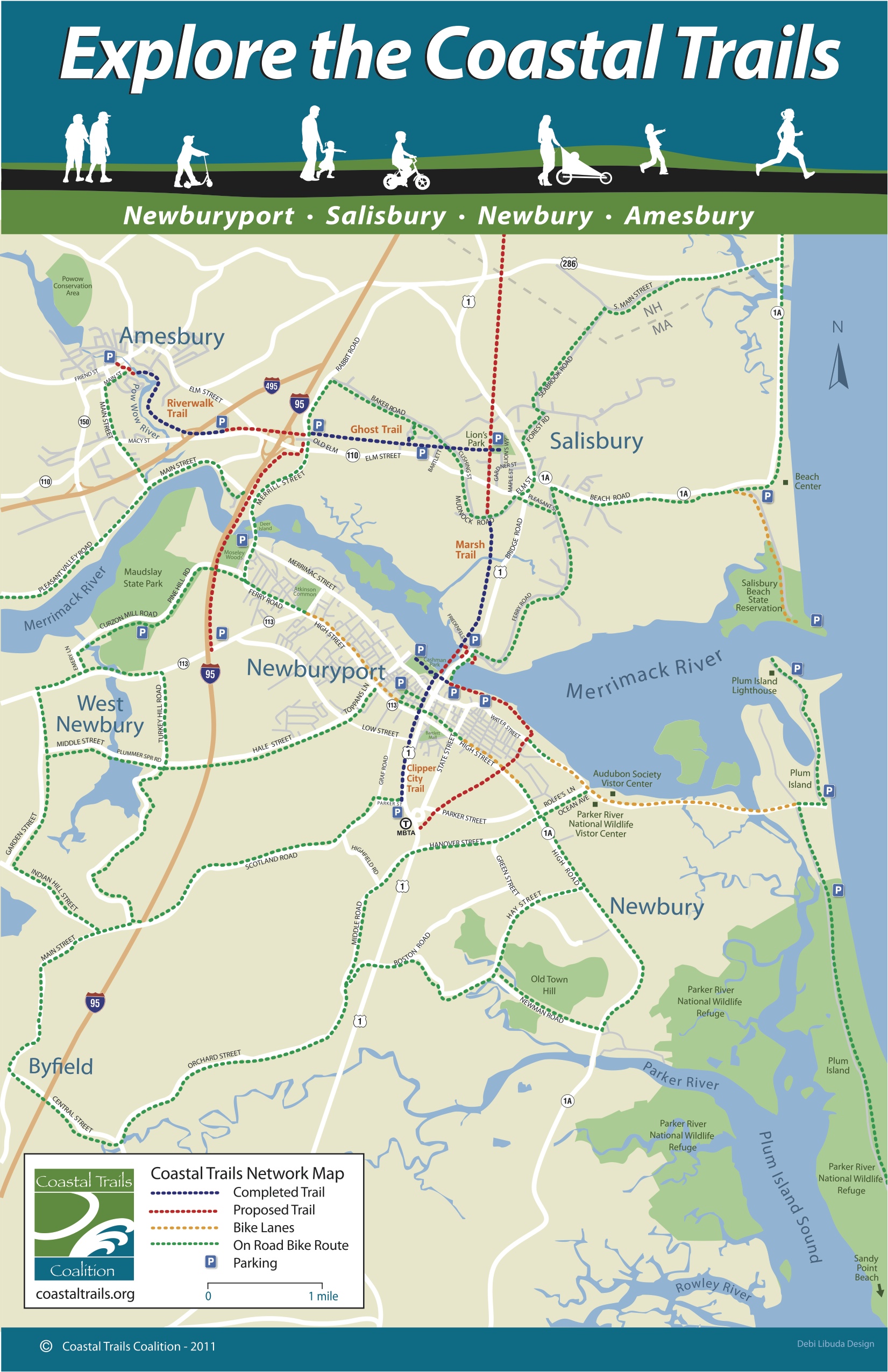
The new Whittier Bridge (carrying I-95 over the Merrimack Newburyport-Amesbury) has a bike path element:
Whittier-Bridge-November-2018-300x172.jpg

and
21543760154_324bff52bf_h.jpg


As part of the creation of the Coast Trails Network. I think the part that opened in late October are the parts in red on this map, below, particularly the outrigger path along I-95 and the path that crosses east-west under it (on the old railroad grade) on the Amesbury side:
ctc_networkmap_final-1-mb.jpg
 
^ My next question is: if we can get a bike path as part of I-95, what does it take to get a bike path on the over-wide bridges that carry Rt 16 across I-93 in Medford? There's something about not being able to take road-width away from "the interstate" if the bridge was built as part of an interstate project (which the Rt 16 bridge was).

At the same time, has policy changed? And now that we're sure that Rt16/MVP will not be part of a multilane highway, can't we nip part of the existing bridge width for bikes (bikes are explicitly excluded from Interstate ROW, so you'd have to somehow "peel off" 16 feet). 6 Years ago I asked Sen Pat Jehlen's office "what would it take" and the answer was "Can't legally be done" (the Feds and the cars have exclusive claim to "the bridge they built")
 
I would say a LOT has changed in the last 6 years. Seems the state senator just might not have wanted to pursue it back then? The cars having "claim" to it makes no sense. Does that mean she didn't advocate for them to make changes to it? I get that Somerville can't just decide to make changes to someone else's road, but was the state/DCR even asked?
 
I would say a LOT has changed in the last 6 years. Seems the state senator just might not have wanted to pursue it back then? The cars having "claim" to it makes no sense. Does that mean she didn't advocate for them to make changes to it? I get that Somerville can't just decide to make changes to someone else's road, but was the state/DCR even asked?

There is something really bogus about the argument that the Fed funded interstate crossing cannot allow bicycle accommodation.

Out west, there are examples of bicycle lanes built directly onto Interstate bridges (the real highway, not a crossing). Example, the I-90 bridge in Seattle:

"The I-90 Lake Washington bike crossing carries traffic both ways on the north side of the twin highway bridges. It's a 9-foot-wide concrete path, with a 54-inch outside steel railing and a 35-inch inside concrete railing. A narrow hazard parking strip separates the bike lane from three lanes of speeding traffic. (Two reversible lanes on another part of the bridge increase the auto capacity each day.)"

https://www.oregonlive.com/cycling/index.ssf/2008/10/washington_freeway_bridges_pro.html
 
Building a bike line *new* on a new or rebuilt Interstate segment is obviously possible. In these cases, though, I can't think of any example where the number of car lanes is reduced. The new Whittier (I-95) and Tappan Zee (I-684) both have very nice outrigger bike Lanes, (and HOV lanes on the TZB/MCB) but neither "took away" any car lanes.

On RT 16/MVP bridge over I-93, however, the question is/was can we *take* a lane that had already been built as part of the Federal Interstates (in this case a road (MA16) at its interchange, necessarily reducing the running lanes on 16 Westbound from 3 to 2, but keeping a wide, paved shoulder.

Here's what I wrote to Sen Jehlen's office in March of 2014:

What might be done to ask the State to take surplus width from the MVP on its bridge over I-93 in Medford and devote that asphalt to bikes and pedestrians?

As a relic of a never-built "inner loop", Rt 16 Westbound is paved about twice as wide as even modern traffic demands as it crosses over I-93. For much of its route from Meadow Glen to the Craddock Bridge, it is a full 3-lanes wide, plus shoulder: 4 full lanes of asphalt, vastly overbuilt for any use it will ever have, given Governor Sargent's cancellation of all "inner" highways in 1970.

Here is a map, with the lane in question shown in [green]:
https://drive.google.com/open?id=19_hwEjhxwWgK-Gl90jp2sO5TfBKnjkdA&usp=sharing

We know width-reduction is legally possible here: Some of the extra bridge with was "taken" over Main St about 10 years ago (and turned into "median")

As highway segments go, this over-wide stretch is unsafe because all the extra pavement, invites speeding, creates confusion over which lane you should be "lining up in", and so induces high-speed weaving.

But as a way to get across I-93, it could provide a key link for non-auto modes.

I am writing to Sen Brownsberger, for his knowledge of biking and the Craddock Bridge. I am writing to Sen Jehlen, Rep Garballey, as representing me in West Medford. And the Medford Bicycle Commission and Councillor Camuso because they might represent Medford's municipal interest in this.

As public works projects go, this could be an inexpensive transformation: as simple as installing a jersey barrier on the right shoulder, topped with chain link, and designating the resulting 8-foot wide paved area a bi-directional bike path.

This might be a near-"free" way to close a critical gap in the pedestrian and cycling "map" of Medford (and Metro Boston)--it could connect the Craddock Bridge in Medford Square via grade-separated path all the way to South Medford, Meadow Glen, the Mystic River Reservation and beyond to 10 Hills Somerville, Assembly Square (and one day, to Boston)

It certainly would better connect Medford Square as a place to walk or bike to or from.

Please let me know how I might help advance this as a possible bike path improvement.

Within 3 days, her Chief of Staff (Tim Snyder) had emailed me back, asked for more details, and set up a call for the next day. But the next day the answer was, roughly: "nothing can be done since we can't take lanes on the i-93 bridge because the restrictions are Federal (not DCR)"

I'd love to hear that this answer was wrong or is now outdated, but where to begin?
 
Last edited:
Building a bike line *new* on a new or rebuilt Interstate segment is obviously possible

This. And regardless of funding source, engineers are very reluctant to add static weight to a bridge, such as the barriers for a bike lane, after the bridge has been designed and constructed for a different weight. There may be legitimate arguments for why it is possible, but it really makes the engineers unhappy.
 
^ Relevant also to note that the deck space that has become the bike lane was used as an auto lane during a couple phases of the construction process. They had both barrels of 95 going over one of the 2 new spans before the old span was demolished, and now that there's only the 4 NB lanes on that new span there's 'extra room' for the bike path.

That's not to say that it was an afterthought...just that the expenditure for the extra deck space wasn't committed on the basis of the bike path alone.
 
https://www.epiccrowdcontrol.com/concrete-jersey-barricades.html says a 10' long Jersey barrier is about 4,000 pounds. To get enough Jersey barriers to equal the weight of one 80,000 pound tractor trailer that I think maybe the engineers might tolerate rolling across that bridge, one needs about 20 of those Jersey barriers, or about a 200' length of Jersey barriers.

I wonder what these anti static weight engineers think will happen to their bridges if a bunch of 80,000 pound 18 wheelers get stuck in traffic and come to a complete stop one behind another on top of these bridges. The trailer part is usually only allowed to be 53' long, so is it possible that each 80,000 pounds might end up taking up less than 100' of road length in that case?
 
So the answer from Peter Sutton is that they've been working on going *under* I-93 (rather than taking space on the bridge), and have even considered taking the ramp to Medford Sq (which had been closed for 2 years and just re-opened). It still appears that FHWA wouldn't permit taking any asphalt from "their" bridge *over* I-93, but that by the time you get the ramp to Medford Sq, you're back on DCR-controlled turf.

The project is called the South Medford Connector and first appeared on dream maps in 2009. In those maps (reproduced in the study as Fig 18) they showed narrowing Rt 16 (relocating the curb both eastbound and westbound) to create multiuse paths.

Here is the 209-page report that was just issued (Oct 2018)
South Medford Connector Feasibility Study
Phase 1 Technical Memorandum
Prepared For:
City of Medford, Massachusetts & Mystic River Watershed Association
Prepared by Nitsch Engineering

...If the Route 16 Exit Ramp can remain closed, or is closed in the future, Alignment A0 would be the recommended alternative. Alignment A0 provides the lowest cost option and minimizes environmental impacts to the embankment between Route 16 and the Mystic River shoreline.

However, if the Route 16 exit ramp does re-open [*1], Alternative A2 was preferred by the Stakeholder Group because it keeps the path vertically aligned with the existing ramp elevation.A2 also provides the most setback from the River, reducing the encroachment into the Riverfront, Buffer Zone, and floodplain.

Though the costs for A2 are significantly higher than A0, if A2 is further pursued additional geotechnical is recommended to further develop the structural design and refine the associated cost.

At Location B [*2], Alternative B2 is the recommended alternative, provided additional structural investigations of the existing drainage culverts indicate that it could support the additional weight of the path and vehicles. If the existing drainage culverts cannot support additional weight, Alternative B3 would be the suggested alternative.If B3 is further pursued, additional geotechnical is recommended to further develop the structural design and refine the associated cost.Since theRoute 16 exit ramp is a critical location within the City of Medford, and it’s open/closed status impacts many current initiatives of the City (including the South Medford Connector Project), the City is pursuing the potential of permanently closing ramp.
[*1] Location A is the pinched shoreline and exit ramp on the *west* side of I-93. The ramp there reopened in Mid-Nov 2018, after the study was published. Alignment A0 re-uses the ramp's asphalt as bikeway.
[*2] Location B is a drainage culvert and outfall on the *east* side of I-93 that has to be bridged
 
Last edited:

Back
Top