Biking the Boston 'Burbs (Trails, MDC, & Towns beyond Hubway area)

I forgot to mention in November that the Winchester paths looked good, except theyre asphalt which looks tacky.
 
The Bruce Freeman Rail trail extension through Acton, Carlisle, and a small section of Concord opened a month back on April third. I just rode it today and it's a beautiful ride, the trail seems pretty wide at most points. There was one section over a main road, but not a highway, where they built a pretty elaborate bridge. There are also a few parts where it meets ponds/lakes. It's honestly becoming my favourite bike trail in the Boston area.

It was a 4.9 mile extension which adds on to the 6.8 miles that was already built back in 2009.
 
Last edited:
Route 2 is going to get another one of those elaborate crossings, but it may be bundled into the redo of the rotary.
 
The Bruce Freeman Rail trail extension through Acton, Carlisle, and a small section of Concord opened a month back on April third. I just rode it today and it's a beautiful ride, the trail seems pretty wide at most points. There was one section over a main road, but not a highway, where they built a pretty elaborate bridge. There are also a few parts where it meets ponds/lakes. It's honestly becoming my favourite bike trail in the Boston area.

It was a 4.9 mile extension which adds on to the 6.8 miles that was already built back in 2009.

Fantastic. I’ve never been, heard of it... it’s hard to justify going way out for anything less than 10 miles but 4.9+6.8 makes it worthwhile. Thanks!
 
MBTA 73 / 71 bus improvement bike lanes

Page 5 of http://www.cambridgema.gov/CDD/Projects/Transportation/~/media/5FFF6527D5AB4DF8A95C7CA7D7074EFF.ashx seems to be proposing that just west of Norumbega St, they seem to think that Belmont St should end up with

  • 9.5' west facing parking lane
  • 6' westbound bike lane
  • 11' westbound travel lane
  • 11' eastbound travel lane
  • 11' eastbound bus / bike lane
  • 7' eastbound facing parking lane

It seems like the westbound bike lane is pretty obviously on the wrong side of the parking lane there. And with 9.5' for the parking lane when perhaps 7' would be adequate, probably 2.5' of parking lane could be reallocated as buffer space between the parking lane and the bike lane.

I'm not sure whether it's worthwhile to try swap the eastbound bus / bike lane with the eastbound facing parking lane. I think such a swap would probably work (unless some car decides to stop itself in the bus lane, at which point the bus would be trapped), but it would also feel really strange, and an 11' bike lane is probably plenty wide enough for bicyclists to pass each other while avoiding getting doored.

Page 8 shows just west of Aberdeen Ave a lack of a westbound bike lane, with a road that is apparently 45' wide. It seems to me that the sensible thing there would be four 10' lanes plus a 5' westbound bike lane; while the westbound bike lane wouldn't have physical protection from any automobiles that might drift into the bike lane, it would at least then have a physically separated bike lane, and since there isn't parking there, hopefully there won't be any dooring that a buffer might be attempting to prevent.
 
Re: MBTA 73 / 71 bus improvement bike lanes

Page 5 of http://www.cambridgema.gov/CDD/Projects/Transportation/~/media/5FFF6527D5AB4DF8A95C7CA7D7074EFF.ashx seems to be proposing that just west of Norumbega St, they seem to think that Belmont St should end up with

  • 9.5' west facing parking lane
  • 6' westbound bike lane
  • 11' westbound travel lane
  • 11' eastbound travel lane
  • 11' eastbound bus / bike lane
  • 7' eastbound facing parking lane

It seems like the westbound bike lane is pretty obviously on the wrong side of the parking lane there. And with 9.5' for the parking lane when perhaps 7' would be adequate, probably 2.5' of parking lane could be reallocated as buffer space between the parking lane and the bike lane.

The parking lane is only 7.5ft the block before and the whole thing has to tie into Belmont's weird 13ft edgeline that somehow serves as a bike lane. A parking protected lane would not be continuous through here given the changes in width of the road each block. I could try to see if a Huron Ave-style buffer works for the next update to the plans though.
 
Re: Bike Lanes in Mt Auburn Bus Priority Project

Would narrowing the two typically 11' automobile travel lanes from Holworthy St to Norman St to 10' each be practical? That would free up 2' that could be used as a buffer between the parking and bike lane, and in several places it looks like one or more of the automobile travel, westbound parking, and westbound bike lanes have a bit of extra space that could be taken to expand that buffer another foot to 3', at which point hopefully the westbound bike lane could be moved to the north of the parking.

https://www.citylab.com/solutions/2...re-saferand-still-move-plenty-of-cars/399761/ seems to think 10' lanes would work just fine.

West of Edward Sullivan Rd, how does the curb to curb width (that is, the width of the road excluding the sidewalk) compare to Cambridge St between Inman and Harvard where the flex post protected pilot was done where the street is generally 44'-45' wide? Has there been any discussion with Belmont residents who are in favor of Belmont building their section of the Mass Central Rail Trail about whether they'd like to see protected bike lanes on Belmont's section of Belmont St in the long term?

Are there any plans to mark the bus / bike lane to discourage bicyclists from riding in the door zone? For example, would it make sense to use dark red paint for the right 3' and left 3' and bright green for the 5' bicycle section in the middle? (Hopefully the contrast between bright green and dark red would be clear enough for people with red-green colorblindness.) Perhaps there could be occasional small gaps in the paint so that the words ``bus lane'' could be painted in red across the black asphalt or concrete for the entire width of the bus lane, and the words ``bike lane'' in green across the bike lane. Or perhaps symbols could be inserted, such as ``bus 🚌 lane'' and ``bike 🚲 lane'' (and the emoji I'm getting for those shouldn't be copied too literally; I'm getting a school bus and not a transit bus). (I think Connecticut requires cars to stay at least 3' away from bikes, which is why I think excluding bikes from the left 3' of the bus lane may be appropriate, and 3' on the right is to keep bikes out of the door zone of the parked cars.)

For westbound bicycles proceeding along Mt Auburn St past Belmont St, would it be possible to provide a protected waiting area and signalize the crossing of the automobile right turn lane? Does the design that has been proposed for that intersection match MassDOT's protected cycle track intersection guidelines?

Which specific section of Huron Ave are you thinking of?
 
What exactly prevented building parking protected bike lanes there, and what's the width of the street from curb to curb there?
 
Cranky neighbors afraid of change (and who didn't want to lose a few parking spaces)
 
Re: MBTA 73 / 71 bus improvement bike lanes

Page 8 shows just west of Aberdeen Ave a lack of a westbound bike lane, with a road that is apparently 45' wide. It seems to me that the sensible thing there would be four 10' lanes plus a 5' westbound bike lane; while the westbound bike lane wouldn't have physical protection from any automobiles that might drift into the bike lane, it would at least then have a physically separated bike lane, and since there isn't parking there, hopefully there won't be any dooring that a buffer might be attempting to prevent.

Does the section of Mt Auburn St between Homer Ave and Aberdeen Ave need two westbound general purpose travel lanes (as opposed to one lane) to deal with traffic volumes and/or any limits to how much green time is available at the Mt Auburn / Aberdeen intersection? It does seem that the bus priority proposal believes that one general purpose eastbound through lane is adequate, and one might expect a certain similarity in peak vehicle volumes in the two directions.

If the second westbound lane could be eliminated, 45' might provide for either 10' eastbound bus and bike lane, 10' eastbound general purpose travel lane, 10' eastbound Mt Auburn left turn lane to Aberdeen, 10' westbound travel lane, and 5' westbound bike lane; or 5' eastbound bike lane, 3' buffer, 10' eastbound travel lane, 10' eastbound left turn lane, 10' westbound lane, 2' buffer, 5' westbound bike lane.
 
Re: MBTA 73 / 71 bus improvement bike lanes

Does the section of Mt Auburn St between Homer Ave and Aberdeen Ave need two westbound general purpose travel lanes (as opposed to one lane) to deal with traffic volumes and/or any limits to how much green time is available at the Mt Auburn / Aberdeen intersection? It does seem that the bus priority proposal believes that one general purpose eastbound through lane is adequate, and one might expect a certain similarity in peak vehicle volumes in the two directions.

If the second westbound lane could be eliminated, 45' might provide for either 10' eastbound bus and bike lane, 10' eastbound general purpose travel lane, 10' eastbound Mt Auburn left turn lane to Aberdeen, 10' westbound travel lane, and 5' westbound bike lane; or 5' eastbound bike lane, 3' buffer, 10' eastbound travel lane, 10' eastbound left turn lane, 10' westbound lane, 2' buffer, 5' westbound bike lane.

Couple months late on the reply. . .

Yes, the lane capacity is indeed legit on these blocks because the medical offices at 625 Mt. Auburn have blown up yuuuuge and that's definitely lengthening queues at the Homer light. My PCP has been based in that complex for 5 years now...and I've never seen the patient parking area as all-day busy as it's been this past year as Mt. Auburn Hospital keeps cramming more new doc offices in there. You've also got that brand new office building tucked in the far back of that same parking lot, and it's probably only a matter of time before somebody buys up the seldom-used rearmost triangle of the Star Market lot to plunk down another set of offices.

It's enough that the eastbound left lane @ Homer is probably going to need to be re-striped as another protected left a la Aberdeen. And that both westbound travel lanes will probably need to be retained on the 2 blocks between Brattle St. merge and Belmont St. split to filet so many right-turnings on and off in a compressed 1200 ft. stretch, because the gridlock would be horrific if there weren't a way to pass that level of turning density. I could see some improvements made around the Star plaza curb cuts on Mt. Auburn-proper just to tidy things up, but generally speaking it's a complex 2-1/2 blocks of artery that's tasked with juggling fast-growing traffic from the med offices and has legit non-inflated need for all 4 lanes even in the event of Mt. Auburn east of Aberdeen/Brattle and west of Belmont getting beneficially lane-dieted down in a multimodal re-striping.

Minimal impact for buses as the westbounds already make decent use of curb turnouts and the cemetery side is pretty orderly for eastbounds. But you might have to go with cycle-tracking on the cemetery side to bridge the two blocks for bikes because the lane capacity is necessary and the turning situation on the westbound side is hairy enough by nature to be a thoroughly unpleasant experience even if there were a full-striped bike lane on that side. It's only an ugly chain-link fence separating sidewalk from cemetery, so as long as the cemetery proves cooperative about removing the first row of unspecial new-growth trees massed up against the fence so the fence can be moved back another 3-6 ft. you'd probably be able to create ample room for installing one of those Concord Ave.-style sidewalk/cycle-track combo jobs here. Then use that to span the 2 blocks in much safer overall fashion than bike lanes that would have to deal with all that compressed right-turning traffic on the westbound side.
 
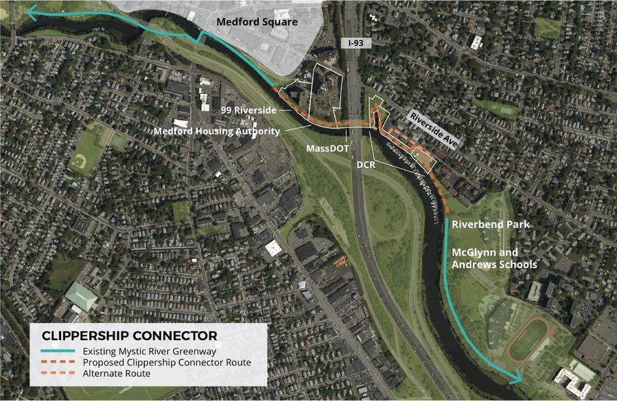
Medford continues to click the parts into place for the "missing link" Clippership Connector, which will connect the Medford Square Mystic riverfront (and other Somerville-Medford-Winchester trails) to the paths that lead around the north side of the Mystic and onward to Assembly and Wellington.

screen-shot-2017-01-17-at-8-27-27-pm.jpg


The 2018 State grants (described below) allow the city to pave the dirth path shown as an orange dotted line, above that is not on a white-bounded parcel.

RTP1865 Medford City of Medford
Riverbend Park
Trail Paving
Riverbend Park is a city-owned section on the Mystic River
Reservation which has a 10 mile network of paved and stabilized
trails frequently used for dog walking, nature walks, and bicycling.
This grant will pave an existing, but unpaved, portion of the trails in
Riverbend Park in anticipation of a significant increase in use, and
to help fund the construction of the portion of the Clippership
Connector that will be on City owned-land.
NM $50,000 $100,000

(The city-owned parcel is not labeled at top, and is located here at 42.412556, -71.100083 and is pictured here (and you can nearly make out the current "beaten path").
image001-1.jpg


This view, below (from the WalkMedford website) shows the to-be-paved path as viewed from the currently-paved path around the McGlynn & Andrews Schools.
unspecified-2.jpg


My guess is that they have not figured out where the north end will tie: will it cut across the DCR-owned parcel that currently serves as a boatyard? Or will it cut inland and pass on the inland side of the boatyard?

Staying at the river's edge is straighter, but would probably be a mess of boats and traffic. Cutting inland (on the light-orange dotted "Alternate Route" at top) would flip that: circuitous but calmer/safer.
 
Last edited:
I've been less intensively following bike projects (biking less too) the past year and a half, sadly.. so Im out of the loop, but was pleased when I googled around any news of the Northern Strand trail -
There's a new mayor in Lynn who supports it (the old troglodyte one had opposed building the path thru Lynn), and the state is going to pay for a paved path all the way from Everett to Lynn. The city is now trying to figure out how to get it connected from where the rail line ends at the MBTA tracks, across, and to the shore. I don't know how long this all will take but it's major progress and sounds like, from what I read, pretty much a done deal. This will be a pretty major trail once it's actually paved - the crushed asphalt parts are pretty uncomfortable to ride on unless you have a mountain bike - and there will be opportunities for connection, hopefully and eventually, to Medford's trails as well. Lynn also is close to Swampscott, so with the Swampscott extension of the Marblehhead trail, it wouldn't take too much improvements on the Lynn roads to get a pretty good connection between those two trails, too.

The shore connection is important, because they have to get it linked to Lynn Shore Drive and utilize the harborwalk there (perhaps augmented with proper cycle track) in order to close the gap to Swampscott. Trail head for the rail trail is at Summer St. right by Lynn Common. Assuming they can also cycle-track up the sidewalk along the Common to continue the grade separation (current sidewalk on the side of the green is a little too narrow to comfortably coexist bikes w/peds), you would only need to get down 3 blocks/1700 ft. of Market St. in mixed traffic to reach the paths + footbridge at North Shore Community College.

Once at North Shore it's easy to augment the existing paths for a couple blocks with an extra cycle track berth until reaching the rotary with Lynn Shore Drive & Nahant Rd. Then go along the beach with another cycle track augmentation of the existing seawall sidewalk, where there's plenty of widening room on the grass to separate bikes from peds.

Not sure how they'd ever maneuver it close to the Marblehead Branch trail. There isn't a mechanism for a direct connection any which way. But I suppose if you cycle-tracked up the length of Lynn Shore Dr. it's then only a 6 or 7 block gap up Monument Ave./Walker Rd. to the Marblehead trail...which probably has to terminate @ Walker because of missing overpass decks at 1A and Stetson Ave. Walker's narrow and a little winding but not all that high-traffic, so wayfinding stripeage may have to suffice. The Marblehead Branch does have pretty excellent grade separation going for it once you get there, crossing mostly very quiet residential streets. So if they can finagle "good enough" wayfinding on that slightly less than half-mile between beach and trail it's smooth sailing the remaining 3.5 miles to downtown Marblehead.
 
That's what I was thinking - you wont have a grade separated connection, but if you can get the two grade separated trails close enough together, and provide for a very safe and heavily used corridor between them, it'll be fine. There's some improvements that could be done to the roads between them that would go a long way toward this.

F-Line - do you think there's a wide enough ROW on the rail line to actually run a cycle track alongside it? That would get a direct connection to the other rail trail. I know it would be expensive, but if there's room to make it work that could be a longer range option. A third possibility might be to have Northern Strand run up the viaduct and then get off at the old spur by Pleasant Street in Lynn.
 
The Eastern Route is graded for 4 tracks throughout Lynn but there's 2 major blockers:


1) The 1990 Lynn station fans out across the full width so it can fit that fat island platform. Any unused track berths would get squeezed out of room on approach, with no nearby up/down access available down to street level to dodge the station.


2) The grade separation above street level doesn't offer any up/down access. The old B&M West Lynn and East Lynn stations have derelict stairs remaining from their 1958 closures, but they're attached to concrete bridge abutments so there's no structural way to ADA them. Add to this difficulty that it's ALSO difficult for emergency crews to access the viaduct through these constraints and ensuring safety patrols through a somewhat high-crime downtown also is impractical.


Yeah...street-level's the only plausible way. At least the unused track berths have a Blue Line future, including a second-wave extension to East Lynn/Swampscott/Salem when the time comes
 
"Derelict stairs"... thats fuckin awesome and prompted some googling... Is this brick ruin the remains of the old station?
 

Back
Top