This just doesn't seem like a good use case for LRT. There are really only three service reasons to use LRT over BRT:
- Capacity: If buses at high frequency can't handle the loads, LRT might be able to. Around 1000 passengers per hour per direction is the point where buses start having difficulty providing enough capacity, especially if mixed traffic and signals lower reliability.
- Dedicated ROW: LRT does great on dedicated ROW like former rail lines, where it can match the speed of buses, and can often fit better than a busway. Conversely, in mixed traffic or with lots of traffic lights, BRT can be substantially faster than buses. Laying embedded tracks in streets also tends to be expensive.
- Going where buses can't: If buses physically can't use the alignment - through-running with existing LRT, time-shared tracks with freight, reusing tunnels too narrow for buses, etc - then LRT can be better. Because LRT can handle the same loads at lower frequency, you can get away with single-track pinches where a single lane would be a problem.
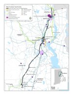
The second and third reasons don't apply here, since it's all on-street. The R-Line (more or less the alternative 1 alignment) had 5,500 daily riders in 2022, well within what buses can handle, and I wouldn't expect a huge ridership increase without a corresponding improvement in speed+frequency+reliability. For the same level of service, LRT will be more expensive to build and operate, and it will likely be slower as well. That's not to say BRT is a magic bullet - it still needs to be designed and operated well - but I think it's the more appropriate mode for Providence. It also lends itself well to high-frequency trunks with branches, which is exactly what this map suggests the demand looks like.