The Elmer Bumpus bridge was built in 1982 - is it because there wasn't a good crossing over the tracks there historically?I'm not actually sure why though, it doesn't seem especially hilly or narrow.

You are using an out of date browser. It may not display this or other websites correctly.
You should upgrade or use an alternative browser.
You should upgrade or use an alternative browser.
Fantasy T maps
- Thread starter cats10000
- Start date


themissinglink
Senior Member
- Joined
- Jan 13, 2018
- Messages
- 2,245
- Reaction score
- 6,464
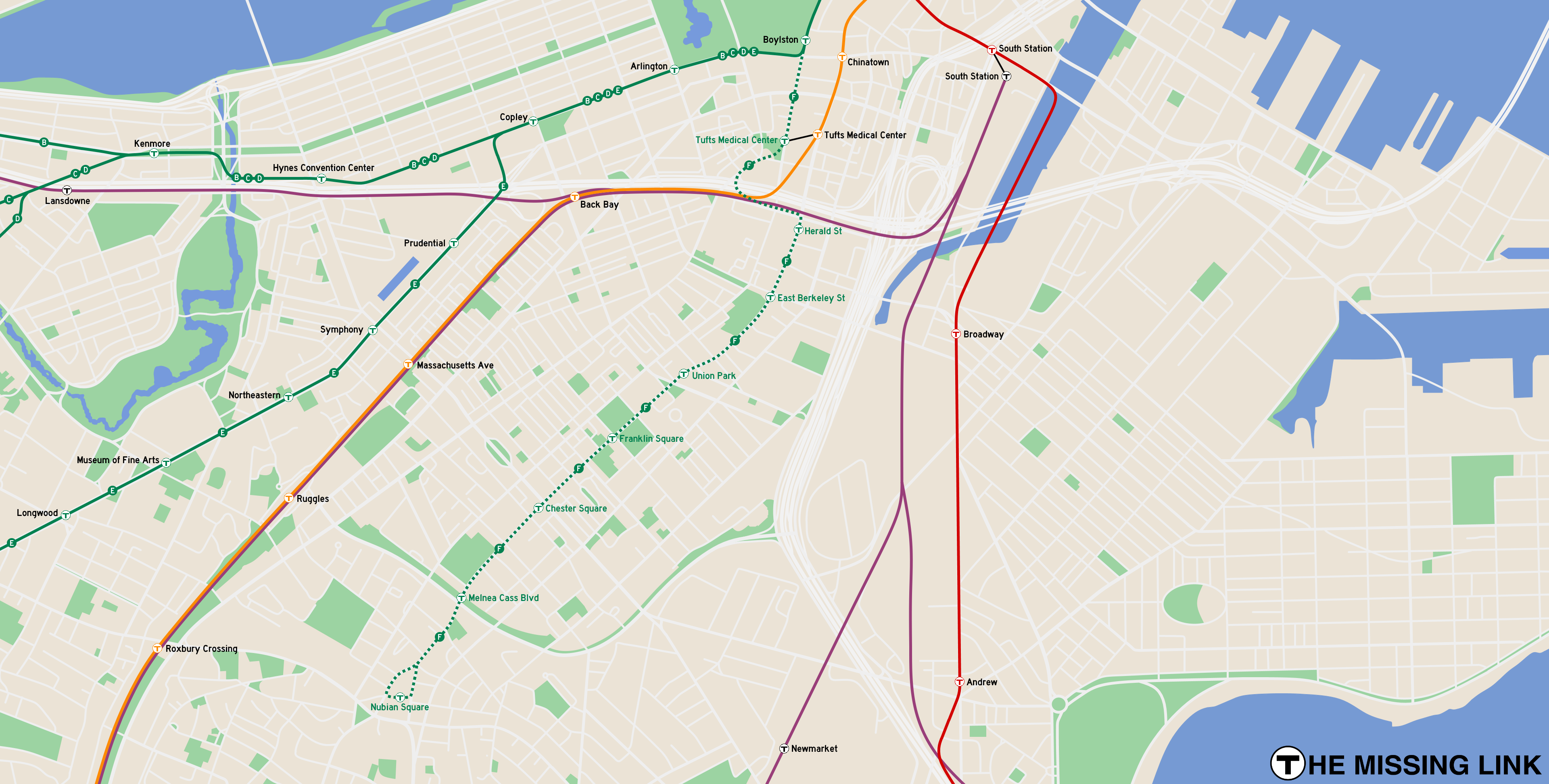
Green Line Extension to Nubian Square
Last edited:
RandomWalk
Senior Member
- Joined
- Feb 2, 2014
- Messages
- 4,063
- Reaction score
- 7,886
Oof, that hairpin after Tufts makes my ears ring.

TheRatmeister
Senior Member
- Joined
- Sep 23, 2023
- Messages
- 1,644
- Reaction score
- 3,382
I have to imagine any such line would put the portal in the location reserved for SL Phase 3, not under Eliot Norton park. That avoids any crazy turns like that.
Justbuildit
Senior Member
- Joined
- Nov 27, 2022
- Messages
- 1,148
- Reaction score
- 4,031
Definitely a much needed infill line through the South End.
Pardon the ignorance, where's the portal for SL3? Wasn't aware there was anything in that area except for the old Pleasant St incline.
Pardon the ignorance, where's the portal for SL3? Wasn't aware there was anything in that area except for the old Pleasant St incline.
themissinglink
Senior Member
- Joined
- Jan 13, 2018
- Messages
- 2,245
- Reaction score
- 6,464
This is the exact alignment I was thinking of when I started working on the map in 2021 (image also includes a Green Line branch to South Station and the Seaport). The portal would be south of the Mass Pike, not under Eliot Norton Park.I have to imagine any such line would put the portal in the location reserved for SL Phase 3, not under Eliot Norton park. That avoids any crazy turns like that.
Last edited:

BosMaineiac
Active Member
- Joined
- Nov 25, 2020
- Messages
- 258
- Reaction score
- 465
Does anyone know where to find the study done on both the Washington St at grade LRV line and also the Shawmut Ave orange line tunnel? I believe these were done around the same time just before the EL came down.
F-Line to Dudley
Superstar
- Joined
- Nov 2, 2010
- Messages
- 10,156
- Reaction score
- 13,103
The traffic island on Tremont @ Marginal. They'd have redone the intersection so the buses portaled up in the middle of the road. The SL III tunnel was actually going to come down Charles St. South in the last plan before the plug got pulled. Underpinning the Tremont trolley tunnel was a cost blowout so that alignment got scrapped pretty early on.Pardon the ignorance, where's the portal for SL3? Wasn't aware there was anything in that area except for the old Pleasant St incline.
It's easier tunneling than going straight down Shawmut because the new underground Tufts Station wouldn't be as constrained (don't forget, the old portal was 4 tracks so if you ever wanted to have multiple branches here you'd ideally want to build Tufts as a twin-island station) and you have a more favorable angle for underpinning the Orange Line. Plus that intersection of Tremont/Marginal sets up a future multi-directional junction if you relocated the E Line off Copley Jct. with a Back Bay Station + Marginal subway. You'd be able to use the quad-track, flying-junction Tremont tunnel to avoid the traffic conflicts of Copley Jct. and be able to thru-route Huntington service to South Station and the Seaport, which is big if you ever build out the Huntington Subway to Brookline Village as a Central Subway alt-spine. That junction features a lot in various Green Line Reconfiguration crayon maps.Oof, that hairpin after Tufts makes my ears ring.
Last edited:
TheRatmeister
Senior Member
- Joined
- Sep 23, 2023
- Messages
- 1,644
- Reaction score
- 3,382
The parcel between Tufts and the Doubletree was originally going to be the portal where buses would turn out onto Washington Street.Definitely a much needed infill line through the South End.
Pardon the ignorance, where's the portal for SL3? Wasn't aware there was anything in that area except for the old Pleasant St incline.
The upside is that it's very easy. There's a clear, straight path for an incline and it puts you out right on Washington Street. The downside are that there isn't room for an underground Tufts Station, so you need a surface station between the portal and Oak Street, which results in a less-than-optimal transfer to the Orange Line. It's possible that downside could be mitigated through an underground passage connecting to the south fare lobby at Tufts, but I'm not sure.
You also lose the option of having a transfer station to a future E branch realignment here but with transfers at Park/DTX and Back Bay I don't think that's a huge downside.
I'm not aware of any such studies that have been publicly released. I don't know how far the original light rail proposal got in planning, but it's my understanding that the Shawmut Ave subway never really got very far, with the SW Corridor being preferred from very early on in the planning process.Does anyone know where to find the study done on both the Washington St at grade LRV line and also the Shawmut Ave orange line tunnel? I believe these were done around the same time just before the EL came down.
Last edited:
BosMaineiac
Active Member
- Joined
- Nov 25, 2020
- Messages
- 258
- Reaction score
- 465
I think what I’m remembering, at least for the light rail option, is this: United States Department of Transportation/Urban Mass Transportation Administration. Replacement/Transit Improvement Study: Alternatives Analysis and Draft Environmental Impact Statement Evaluation, Draft June 1987I'm not aware of any such studies that have been publicly released. I don't know how far the original light rail proposal got in planning, but it's my understanding that the Shawmut Ave subway never really got very far, with the SW Corridor being preferred from very early on in the planning process.
I believe this was the impetus for the BRT decision. They identified issues with the street width and, construction concerns from abutters, and, of course, cost. I can’t find the actual report, though.
themissinglink
Senior Member
- Joined
- Jan 13, 2018
- Messages
- 2,245
- Reaction score
- 6,464
Wasn't there also a study by the MBTA in the 1970s for a Green Line tunnel under Washington Street to Nubian (then Dudley) Square? I remember someone posting a link to the study on this site in the past 3 or 4 years. I'll look and see if I can find it.
F-Line to Dudley
Superstar
- Joined
- Nov 2, 2010
- Messages
- 10,156
- Reaction score
- 13,103
1972 Boston Transportation Planning Review. The complete study isn't available online, only the Executive Summary. Which is weird that it hasn't been scanned out of the State Transportation Library yet because it was a major big-deal comprehensive planning study that influenced immediate action on the SW Corridor redesign post- I-95 cancellation, the Red Line northwest extension, and the Big Dig.Wasn't there also a study by the MBTA in the 1970s for a Green Line tunnel under Washington Street to Nubian (then Dudley) Square? I remember someone posting a link to the study on this site in the past 3 or 4 years. I'll look and see if I can find it.
I don't believe it was ever studied back then as a complete-to-Dudley tunnel. They were always looking at it as a streetcar line, and I believe the lone screenshot I ever saw of it extended the Tremont tunnel down Shawmut to a portal along Marginal with no intermediate station.
themissinglink
Senior Member
- Joined
- Jan 13, 2018
- Messages
- 2,245
- Reaction score
- 6,464
Green Line Extension to Mystic Valley Parkway
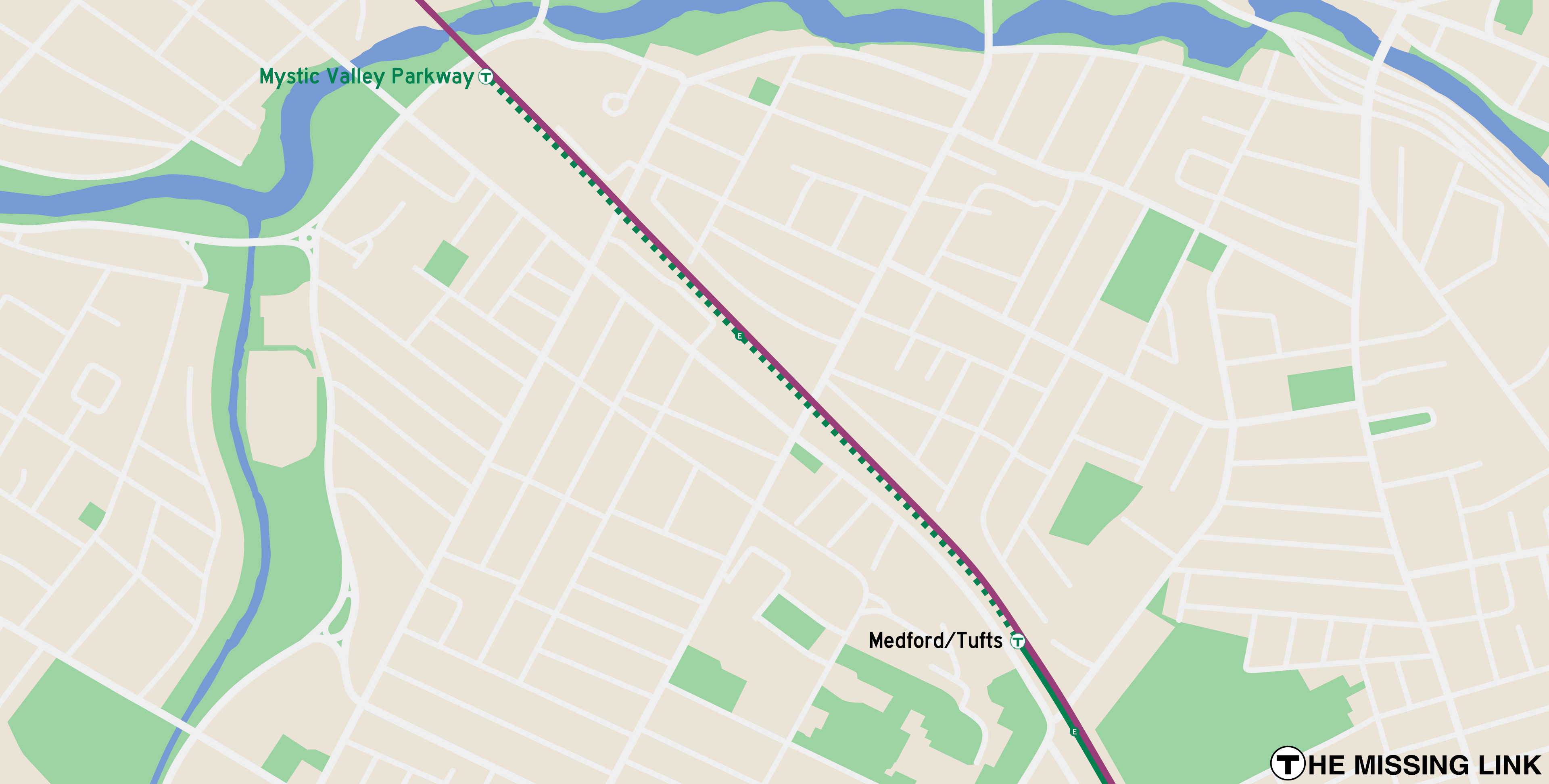
This expansion would be the simplest and cheapest of all potential rapid transit extensions. It's disappointing that there are no serious plans to build it and finish the Green Line Extension.
This expansion would be the simplest and cheapest of all potential rapid transit extensions. It's disappointing that there are no serious plans to build it and finish the Green Line Extension.
Last edited:
I've got a request. I'd love to see a fantasy map that shows the network with the NSRL and S-Bahn-like service running through it. Specifically that would mean running Regional Rail trains at subway-like frequencies inside 128. Then it would make sense to show those lines as equals to the rest of the subway lines. German cities tend to do that with their transit maps, showing S-Bahn and U-Bahn routes on one map with little distinction between them (like Berlin or Munich).
That would give Boston effectively four new subway lines. You could combine the North and South routes different ways, but for example: Braintree to Waltham; Readville to Woburn via Fairmount; Canton to Reading via Back Bay; Framingham to Salem. You could also make other reasonable changes, like dropping the Needham Line in favor of Orange and Green Line Extensions.
This seems like such a major expansion, the map would need to be redone from scratch (probably). I have no talent for this, but if it strikes anyone's interest, I'd love to see it. It might even be useful for some NSRL advocacy.
themissinglink
Senior Member
- Joined
- Jan 13, 2018
- Messages
- 2,245
- Reaction score
- 6,464
Here's my attempt at adding Regional Rail and the NSRL to an existing map I made a few years ago:I've got a request. I'd love to see a fantasy map that shows the network with the NSRL and S-Bahn-like service running through it. Specifically that would mean running Regional Rail trains at subway-like frequencies inside 128. Then it would make sense to show those lines as equals to the rest of the subway lines. German cities tend to do that with their transit maps, showing S-Bahn and U-Bahn routes on one map with little distinction between them (like Berlin or Munich).
That would give Boston effectively four new subway lines. You could combine the North and South routes different ways, but for example: Braintree to Waltham; Readville to Woburn via Fairmount; Canton to Reading via Back Bay; Framingham to Salem. You could also make other reasonable changes, like dropping the Needham Line in favor of Orange and Green Line Extensions.
This seems like such a major expansion, the map would need to be redone from scratch (probably). I have no talent for this, but if it strikes anyone's interest, I'd love to see it. It might even be useful for some NSRL advocacy.
Last edited:
TheRatmeister
Senior Member
- Joined
- Sep 23, 2023
- Messages
- 1,644
- Reaction score
- 3,382
I've got a request. I'd love to see a fantasy map that shows the network with the NSRL and S-Bahn-like service running through it. Specifically that would mean running Regional Rail trains at subway-like frequencies inside 128. Then it would make sense to show those lines as equals to the rest of the subway lines. German cities tend to do that with their transit maps, showing S-Bahn and U-Bahn routes on one map with little distinction between them (like Berlin or Munich).
That would give Boston effectively four new subway lines. You could combine the North and South routes different ways, but for example: Braintree to Waltham; Readville to Woburn via Fairmount; Canton to Reading via Back Bay; Framingham to Salem. You could also make other reasonable changes, like dropping the Needham Line in favor of Orange and Green Line Extensions.
This seems like such a major expansion, the map would need to be redone from scratch (probably). I have no talent for this, but if it strikes anyone's interest, I'd love to see it. It might even be useful for some NSRL advocacy.
<chanting> Do it! Do it! Do it!
It looks good. I will say, what I had in mind was more specifically that the new lines be basically indistinguishable from other subway lines. I think that means lines for the new routes should be shown the full width of existing subways, and each with their own color (maybe like a set of four pastels or something). Maybe at that point the new lines need names, like RR1, RR2, RR3, RR4, or something like that. It would be a way to show that with NSRL (and other improvements) you essentially get four new express subway lines across the region.
Again, the Munich transit diagram is one I had in mind. U-Bahn and S-Bahn have different labels at the end of the lines, but on the map they're interchangeable ways of getting around. It's all one, unified system.
And obviously, that's just my thinking. You know what you're doing. I'm glad you're taking up the challenge!
TheRatmeister
Senior Member
- Joined
- Sep 23, 2023
- Messages
- 1,644
- Reaction score
- 3,382
I've been to Munich, and I think it's a good parallel, and also demonstrates why I don't think giving the regional rail and subway lines equal thickness is actually reasonable. In the central tunnel S-Bahn trains come every ~2 minutes, it's the most frequent rail line in the city. Outside the central tunnel, each line only comes every ~20 minutes or so, half of the average frequency of an individual U-Bahn Line (Or 1/4 the frequency of the common 2-line U-Bahn sections).<chanting> Do it! Do it! Do it!
It looks good. I will say, what I had in mind was more specifically that the new lines be basically indistinguishable from other subway lines. I think that means lines for the new routes should be shown the full width of existing subways, and each with their own color (maybe like a set of four pastels or something). Maybe at that point the new lines need names, like RR1, RR2, RR3, RR4, or something like that. It would be a way to show that with NSRL (and other improvements) you essentially get four new express subway lines across the region.
Again, the Munich transit diagram is one I had in mind. U-Bahn and S-Bahn have different labels at the end of the lines, but on the map they're interchangeable ways of getting around. It's all one, unified system.
View attachment 75008
And obviously, that's just my thinking. You know what you're doing. I'm glad you're taking up the challenge!
In Boston, we'd likely see something similar. I'm not putting too much thought into service patterns and am leaning rather optimistic when I have to make a choice, so I have service in the central tunnel every 2 minutes, service within 128 every 5-8 minutes, and service outside 128 every 15-30 minutes. The goal is that the central NSRL is the thickest, the portions within 128 are a comparable weight to the subway lines, and the portions outside 128 are noticeably thinner. In terms of routes, I've mostly settled on 9 routes, each every 15 minutes, tentatively labeled PL1-PL9 with an X added for express services since I'm also being incredibly generous with infills. They are:
| Route | Start | End |
| PL1 | Weston/128 | Quincy Center (Continuing to Greenbush/Kingston) |
| PL2 | 1/2 from Littleton/495 -> Weston/128 | Brockton (1/2 continuing to Middleborough) |
| PL3X | 1/2 from Wachusett, 1/2 from Littleton/495 -> Weston/128 | Readville |
| PL4X | Anderson/Woburn | Canton Junction continuing to Fall River/New Bedford/Providence (1:1:2 ratio) |
| PL5 | Lowell | Walpole (Continuing to Foxboro/Forge Park) |
| PL6 | Haverhill | Readville |
| PL7 | Beverly | Mansfield |
| PL8X | Newburyport | Framingham (1/2 continue to Worcester) |
| PL9 | Rockport | Framingham |
For peak service, some or most short-turns get extended.
Last edited:
I see. I forgot the Munich branches were so infrequent.I've been to Munich, and I think it's a good parallel, and also demonstrates why I don't think giving the regional rail and subway lines equal thickness is actually reasonable. In the central tunnel S-Bahn trains come every ~2 minutes, it's the most frequent rail line in the city. Outside the central tunnel, each line only comes every ~20 minutes or so, half of the average frequency of an individual U-Bahn Line (Or 1/4 the frequency of the common 2-line U-Bahn sections).
I have service in the central tunnel every 2 minutes, service within 128 every 5-8 minutes,
This mostly makes sense. But if Regional Rail trains are running every 5-8 minutes inside 128, to me, those are subways. So I don't know why they get a "comparable weight" to the other subways. They should probably just be the same. They're subways.the portions within 128 are a comparable weight to the subway lines, and the portions outside 128 are noticeably thinner.
Then noticeably thinner lines past 128 makes a lot of sense. Like, with some label just saying "to Newburyport," maybe?