
BosMaineiac
Active Member
- Joined
- Nov 25, 2020
- Messages
- 254
- Reaction score
- 464
The removal of the bridge piers is huge for a grade-separated grand junction tie-in. So much more space underneath the span now.

The removal of the bridge piers is huge for a grade-separated grand junction tie-in. So much more space underneath the span now.


It's a parkway. So it's crazy to require 12' lanes and 8' shoulders. This is not an interstate expressway, it's a multi-use corridor, a parkway. I'm a civil engineer who designed roads on National Parks, road projects which were federally funded. All kinds of design exceptions were made to make the roadways compatible with their context, which is exactly what needs to be done here.
Updated alternatives for Reid Overpass. There was an information meeting today. Attendees and cycling advocates were present from around the metro area and it was near consensus for the second alternative. This was mostly because of the fact that people may block the box at the signalized intersection and that the roadway was too wide. However where the problem lies is that the required lane widths are 12’ with 8’ shoulders for something like this considering it’s federally funded. MassDOT AND DCR want 10’ lanes with a 2’ shoulders. This however would require approval from the Federal Highway Administration since it is a federally funded project. At least this was what was told to me.
Also, the state senator who proposed automated traffic enforcement was present and said it will most likely be passed in October as part of the economic development bill and that they are looking into expanding to non safety zone roadways, and if this ends up happening it was mentioned by MassDOT staff that they would most likely install them on the overpass.
The first design is laughable. Literally looks like something out of texas or arizona. Glad everyone had the sensibility to strike that down.
Updated alternatives for Reid Overpass. There was an information meeting today. Attendees and cycling advocates were present from around the metro area and it was near consensus for the second alternative. This was mostly because of the fact that people may block the box at the signalized intersection and that the roadway was too wide. However where the problem lies is that the required lane widths are 12’ with 8’ shoulders for something like this considering it’s federally funded. MassDOT AND DCR want 10’ lanes with a 2’ shoulders. This however would require approval from the Federal Highway Administration since it is a federally funded project. At least this was what was told to me.
Also, the state senator who proposed automated traffic enforcement was present and said it will most likely be passed in October as part of the economic development bill and that they are looking into expanding to non safety zone roadways, and if this ends up happening it was mentioned by MassDOT staff that they would most likely install them on the overpass.
It looks like what was built at Arborway & South St in Jamaica Plain, something I've navigated in all modes of transportation many times, most often on bicycle, and is deeply flawed.The first design is laughable. Literally looks like something out of texas or arizona. Glad everyone had the sensibility to strike that down.
In no sense other than words on paper are most of the DCR Parkways actually "park ways" in the sense of being access to park land or with recreational functions as anywhere near the primary function of the road. They're major arterial roads that serve heavy commuter loads and that's what they've been designed as for the past 70+ years and what the metro area has been built around them serving.It's a parkway. So it's crazy to require 12' lanes and 8' shoulders. This is not an interstate expressway, it's a multi-use corridor, a parkway. I'm a civil engineer who designed roads on National Parks, road projects which were federally funded. All kinds of design exceptions were made to make the roadways compatible with their context, which is exactly what needs to be done here.

 mass.streetsblog.org
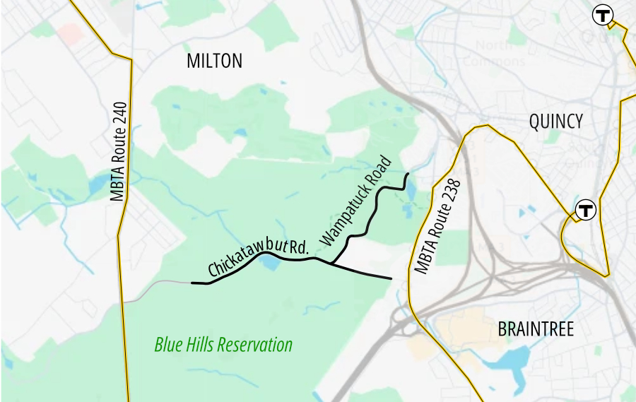
In an effort to improve safety, reduce air pollution inside the park, and enhance recreational opportunities, DCR will close gates at the Chickatawbut Overlook (about 1 kilometer east of Randolph Road in Milton), at Purgatory Road near Granite Street in Braintree, and on Wampatuck Road at Bunker Hill Lane in Quincy.
The vehicular traffic closures will extend on weekends, 5 p.m. Friday through 6 p.m. each Sunday, through September 6, in an effort to quash illegal nighttime drag races that have afflicted the park.
In no sense other than words on paper are most of the DCR Parkways actually "park ways" in the sense of being access to park land or with recreational functions as anywhere near the primary function of the road. They're major arterial roads that serve heavy commuter loads and that's what they've been designed as for the past 70+ years and what the metro area has been built around them serving.
They are arguably closer to the "Garden State Parkway", "Merritt Parkway", or the other thousand roads in the Northeast that use the word "parkway" and are barely related to "parks" beyond maybe having a few extra trees, than they are "a road to provide access to parkland".
Most roads in most National Parks exist to provide access to that area of land for recreation, and any other uses are very low on the list of functions/goals for that road - some may have some other tangential use, but it's not what most of the road use is oriented around.
--------
Beyond this, while they haven't publicized anything that I see, I assume the funding here for redesign is coming from standard federal highway funds rather than the funding National Park roads are funded from.
I know you know all this, and I find it hard to believe you are really as incredulous as you act here as to why proposals for key, high-volume arterial roads in the Boston metro area do not look like the proposals for roads in a remote National Park. Same with being surprised that agencies are probably much more reluctant to make exceptions to any standards that may exist for a road like this that serves tens of thousands of commuters a day than they are in a National Park.
------
Anyway, with all that said - the option with the overpass looks obviously better and I hope is what gets built.
I would like to emphasize this point. The metropolitan parkway system was conceived and built out long before automobile commuting from the suburbs was a regular practice. The MPC (Metropolitan Park Commission, later MDC, now DCR) started working on these roads in around 1900. Most were completed before 1920. The primary emphasis of these roads was to provide access to the regional park system for the emerging upper middle class urban dwellers. The use restrictions for these roads originally read for use by "pleasure vehicles" -- that is not a commuting use. You can tell that the people who build nice homes on Fresh Pond Parkway in the 1920s never expected that road to become a commuting hell hole.I have to disagree. Most of the DCR parkways are actually parkways, consisting of an arterial road providing access to substantial multi-use park corridors. Memorial Drive is one of those. The arterial road you refer to is just one of several key uses of the parkway corridor, along with bicycles and pedestrians. Granted, there are a few, such as Revere Beach Parkway and the Fellsway south of Roosevelt Circle in Medford, that lack any substantive park land, but they are the exception. And yes, the last 70 years saw the MDC widen several of the parkway roads into multi-lane highways, but I chalk that up to the post WW-II car mania that dictated transportation policy all around. Hopefully we live in a more enlightened time in which we realize the parkway corridor serves several transportation modes, including active (human powered) transportation, as well as the innate worth of the park land itself..
MassDOT needs to radically change its auto-centric view, do a 180 and start thinking of these parkways as a multi-use context-sensitive corridor, just like the National Park Service's (NPS) approach to reconstruction of roads passing through our National Parks. I worked with NPS a lot as a designer of major road reconstruction projects, using Federal funds of the same exact type as those to be used on this Memorial Drive project, and I can guarantee you that NPS was fully committed to preserving and enhancing the experience along their roads for ALL users. Cars were just one element of the mix, not the primary element, as MassDOT seems to think. If MassDOT had the vision and courage, they would pursue design exceptions as vehemently and successfully as the NPS did for their road projects. 12' lanes and 8' wide shoulders is absurd for DCR parkways.
A "complete streets" emphasis needs to be adopted by DCR and MassDOT for these parkway roads. I don't care how much suburban commuter traffic uses these roads. The roadways need to be reconfigured as multi-mode active transportation - along with motorized use - corridors. If that causes increased vehicular congestion, then that will just force more commuters to use transit and commuter rail instead.I would like to emphasize this point. The metropolitan parkway system was conceived and built out long before automobile commuting from the suburbs was a regular practice. The MPC (Metropolitan Park Commission, later MDC, now DCR) started working on these roads in around 1900. Most were completed before 1920. The primary emphasis of these roads was to provide access to the regional park system for the emerging upper middle class urban dwellers. The use restrictions for these roads originally read for use by "pleasure vehicles" -- that is not a commuting use. You can tell that the people who build nice homes on Fresh Pond Parkway in the 1920s never expected that road to become a commuting hell hole.
White flight to the suburbs after WW II hijacked these roadways into commuting arteries, a use they were never designed for.
The solution is to narrow Route 2 from Alewife all the way out to Rte 128/I-95. Narrow Route 2 from 4 lanes to 2 lanes in each direction, and convert the vacated lanes on both sides of the highway into park land with muti-use trails. Another option would be two general traffic lanes in each direction, plus a dedicated bus-only lane, and of course add in the multi-use trails.Alewife Brook is load bearing because the expressway section of Route 2 connects to it. I wish there was a way to restore the park emphasis on that stretch north of Route 2.
The solution is to narrow Route 2 from Alewife all the way out to Rte 128/I-95.
Yes, it would seriously squeeze the traffic capacity on Rte 2, but that would lessen, maybe even eliminate, the bottleneck where it hits Alewife. Plus, a great link in the metropolitan bike/ped trail system would be added, from the Minuteman Trail at Alewife all the way out to Lincoln.Traffic really isn't a problem in that stretch of Route 2 until you get near Alewife but probally would be if you did that.
Adjusting the outer lanes of Rt 2 would be enormously expensive because of all the exit/entrance ramps and frontage roads. And all that for... a multi-use path directly adjacent to a high-traffic road? Ew.The solution is to narrow Route 2 from Alewife all the way out to Rte 128/I-95. Narrow Route 2 from 4 lanes to 2 lanes in each direction, and convert the vacated lanes on both sides of the highway into park land with muti-use trails. Another option would be two general traffic lanes in each direction, plus a dedicated bus-only lane, and of course add in the multi-use trails.

Not to mention, it's not a great route for bicycles because of the hill.Adjusting the outer lanes of Rt 2 would be enormously expensive because of all the exit/entrance ramps and frontage roads. And all that for... a multi-use path directly adjacent to a high-traffic road? Ew.

Yeah, I'm not sure a non-Olympian could use a cycle path along Route 2.Not to mention, it's not a great route for bicycles because of the hill.