You are using an out of date browser. It may not display this or other websites correctly.
You should upgrade or use an alternative browser.
You should upgrade or use an alternative browser.
🔷 Open Thread
- Thread starter statler
- Start date
JohnAKeith
Senior Member
- Joined
- Dec 24, 2008
- Messages
- 4,337
- Reaction score
- 82
^ awesome
An old thread I stumbled on for anyone who's ever thought about if we all see the same color, or if my red is your blue. Starts with hypothesis what UV would "look" like.
Also this
An old thread I stumbled on for anyone who's ever thought about if we all see the same color, or if my red is your blue. Starts with hypothesis what UV would "look" like.
The answer to "if we could see ultraviolet light, what would it look like?" rather depends on exactly in what sense we could see it.
If the the range of our eyes cones were extended such that one or more types of cones could receive partially in the ultraviolet range (and the sensitivity within other ranges were modified such that we could resolve ultraviolet light in isolation), then UV would look like our current limit of purple.
If we had another type of cone in the eye explicitly for this range then we'd probably see UV as another primary colour. And describing it as a deep purple would be like describing red as a deep green.
If we had more than one extra type of cone, we'd probably have more than one extra primary colour.
Of course beneath all this is the philosophical issue of how we can know whether we're seeing the same colour, and how we could ever even begin to describe the phenomenal experience of colour using words
Also this
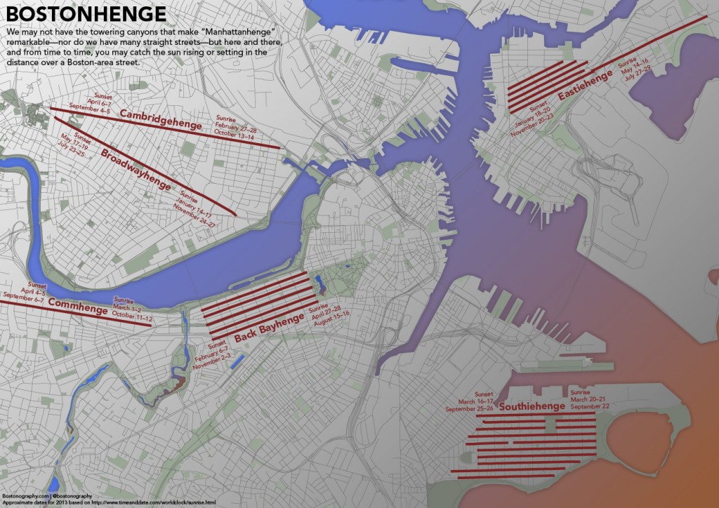
BostonUrbEx
Senior Member
- Joined
- Mar 13, 2010
- Messages
- 4,340
- Reaction score
- 130
Ron Newman
Senior Member
- Joined
- May 30, 2006
- Messages
- 8,395
- Reaction score
- 13
A lot of the rest of NYC is on other grids, though.
- Joined
- Sep 15, 2010
- Messages
- 8,894
- Reaction score
- 271
There's a really simple explanation to the Boston issue, especially in the area they chose to show. They're showing freakin' Roxbury and Mission Hill which have extreme terrain and the roads follow the contours (as to Olmstead's liking).
The picture would actually make sense and be funny if they had used a picture of downtown Boston instead of Roxbury. Downtown Boston is an absolute disaster. They probably originally tried that, but they couldn't figure out a way to hide the Back Bay grid.
The picture would actually make sense and be funny if they had used a picture of downtown Boston instead of Roxbury. Downtown Boston is an absolute disaster. They probably originally tried that, but they couldn't figure out a way to hide the Back Bay grid.
czsz
Senior Member
- Joined
- Jan 12, 2007
- Messages
- 6,043
- Reaction score
- 7
A lot of the rest of NYC is on other grids, though.
Yeah, but they interlock in weird and confusing ways, and that's when they do exist. Lower Manhattan (which is really at least half of the chunk of Manhattan that's really important and well-visited) isn't on any sort of grid system for the most part, though. And the entirety of Central Boston, from the North End to Longwood, could fit inside it.
Honestly, the real comparison should be with Chicago, which has a fairly pure grid the whole city through, with the exception of a few diagonal boulevards and interruptions from rivers. The streets even interlock into the Northwest Ordinance township line system that was used to divvy up the entire Midwest!
Ron Newman
Senior Member
- Joined
- May 30, 2006
- Messages
- 8,395
- Reaction score
- 13
is there a Mainhenge in Cambridge too?
JohnAKeith
Senior Member
- Joined
- Dec 24, 2008
- Messages
- 4,337
- Reaction score
- 82

Why is everyone so grouchy around here?
- Joined
- May 25, 2006
- Messages
- 7,033
- Reaction score
- 1,865
Seriously people, grow up.
Downburst
Senior Member
- Joined
- Jul 20, 2012
- Messages
- 1,452
- Reaction score
- 347
Hey, all.
I'm sure some/most of you are familiar with Minecraft. I'm going to attempt building some scale models of Boston developments in Minecraft, but I need help with dimensions. Heights, of course, are easy, but length and width elude me, and I've been searching for over an hour already trying to find the Pru's dimensions.
Does anyone have any potentially helpful information here? Direct measurements or resources I could use? I'd be really appreciative.


