Aerials

When all is said and done, the blocks in this aerial (with the two North End blocks) pretty much constitute the entirety of the Greenway. Nearly every block out of view will be built on with museums, cultural/social centers, or infill.
2-20-08_boston_stock_4106-126%20copy.jpg
 
The first is recent, with 33 Arch (2004) standing. The 2nd and third are from around 1990 with One International Place ('87) but not TWO IP ('92).
 
the first video was posted on Youtube in Jan. of 2007, but the video is taken in the summer (greenery everywhere). The Intercontinental appears to be completely finished and skinned, so I am guessing its summer of 2006.
 
In the second one you can see 222 Berkeley Street under construction ... completed in 1991.

In the third video you can see 125 Summer Street under construction, that was completed in 1989.
 
Old Aerials

a re-post from 5 years ago on the old SSG board ... i think these were taken around 1920:


120076v.jpg


120077v.jpg
 
Looks nice without Storrow Drive. I bet is was actually pretty quiet over there too!
 
It's not only without Storrow Drive, it's also without the Hatch Shell, the lagoon, or the islands.
 
Wow...these are insightful. I didn't know the old MIT campus had three buildings and that entire block. Also - what's with all the empty space in the southern Back Bay? What's that gargantuan long building on St. James? The building with the courtyards between St. James and Stuart? What is that round building at Arlington and Columbus? Is the building with the steeple across the street the old rail station left shorn of its purpose?
 
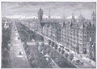
The 'gargantuan long building on St. James' is still there. It is called the Park Square Building, and contains mostly offices with some retail.

Of those three free-standing buildings between Clarendon and Berkeley, the one not built for MIT is still there. It was originally the Museum of Natural History, which is now (in greatly changed form and location) the Museum of Science. The building contained a Bonwit Teller store in the 1970s, and now contains Louis-Boston.

The other two (MIT) buildings were torn down and replaced by the New England Mutual Life Insurance building (now called 'The Newbry').

I think the 'building with the steeple across the street' is the First Corps of Cadets armory, still standing today as the Park Plaza Castle.

I have no idea about the round building. Some sort of storage tank, maybe?
 
Last edited:
Huh, you're right about the Park Square Building; funny I never noticed it. And now that you mention it, that building on Columbus and Arlington is indeed the castle. It looked to me like it might still be the Boston & Providence station:

http://www.kellscraft.com/bostonillustrated/bostonillust043.jpg

Were parts of the station incorporated into the armony, by any chance?

Here's a shot of the old Boylston-Berkeley-Clarendon-Newbury block that used to house MIT...apparently the building still standing was originally built as a YMCA.

http://www.kellscraft.com/bostonillustrated/bostonillust050.jpg

Another find: the original Harvard Medical School, at Boylston and Exeter:

http://www.kellscraft.com/bostonillustrated/bostonillust052.jpg

I found these, by the way, in an 1880s illustrated guide to Boston that's been reproduced here:

http://www.kellscraft.com/bostonillustrated/bostonillustratedcontent.html

Back Bay is filed under "West End"...at the time, it was apparently considered the "New West End" much like today's South End aped its name from what is now the Financial District.
 
Last edited:
Hm, they don't seem to want to work. Click on the last link and work your way through the "West End" section. You'll see them.

Also recommended: the "practical info" part - amazing how little a nice hotel cost back then.
 
If you look at 1895 maps of Boston, and compare them to 1928 maps, you'll see the reason for "all the empty space in the southern Back Bay" -- namely, that it had only recently been vacated by railroads.

This 1895 map identifies the round building as a "Gasometer". Note that Arlington Street did not then extend south of Boylston Street, and that the same street south of Columbus Ave. was then called Ferdinand Street. (Goes along nicely with intersecting Cortes and Isabella streets.) The Gasometer has vanished from the 1928 map.

I don't think the Natural History (Bonwit-Teller, Louis-Boston) building was ever a YMCA. This is an incorrect reading of the old text, or maybe a caption error. The 1895 map shows a YMCA at the southwest corner of Berkeley and Boylston, across the street from Natural History.

And "The building with the courtyards between St. James and Stuart"? Looks to me like part of the Old John Hancock building complex, still standing today.
 
Last edited:
Now this:
bostonillust055.jpg
looks positively Parisian! Great site about historic Boston, really shows the granduer of old Boston.
 
I wanted to check something out on Google maps and I noticed that they just updated all the aerial photography for downtown Boston and Cambridge. I think as early as last week the satellite aerials showed the Cetnral Artery still up, and now you have the Matriarch of the Alcoholic Crime Family Greenway and other new developments presented. Also, the imagery seems a lot better.

I think they were taken in late summer of 2007. Early morning, judging by the shadows. It's a huge improvement.
 
Looks like Google is now using satalite for Cambridge, not the plane shots. Surprisingly however, Cambridge still has its extra zoom level.

The use of summer images makes the city look nicer.
 
3-30-08_boston_stock_4140-210%20copy.jpg


This is exactly why there will never be a 800' tower at the Gateway Center and why all the buildings in the SBW are short.
 

Back
Top