You are using an out of date browser. It may not display this or other websites correctly.
You should upgrade or use an alternative browser.
You should upgrade or use an alternative browser.
Aerials
- Thread starter Mike
- Start date
Im sorry, but you cant make Boston look like something its not.
The goal of the aerials were to capture the local urbanism and see how it compares to other areas around it.
And you did a great job of it in those pictures - - thank you!
KentXie
Senior Member
- Joined
- May 25, 2006
- Messages
- 4,195
- Reaction score
- 766
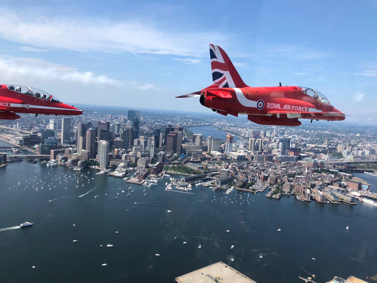
Shot from one of the Red Arrows that flew over today.
https://pbs.twimg.com/media/ECWLhFcWwAA2Dp-?format=jpg&name=large
https://pbs.twimg.com/media/ECWLhFcWwAA2Dp-?format=jpg&name=large
atlantaden
Senior Member
- Joined
- May 31, 2006
- Messages
- 2,606
- Reaction score
- 2,748
WOW!!! Spectacular shot!!!
- Joined
- May 25, 2006
- Messages
- 7,034
- Reaction score
- 1,865
The British are coming. And this time, it's personal!
Charlie_mta
Senior Member
- Joined
- Jul 15, 2006
- Messages
- 4,561
- Reaction score
- 6,489
The British are coming. And this time, it's personal!
Ha! Good one.
This is a roundabout way of getting there, but Reebok introduced a new retro logo, and as they've put the logo on their new HQ at Black Falcon, they did a nice little aerial video of it with some great shots of the skyline and, more importantly, Southie. At the bottom of this page: https://www.underconsideration.com/...eebok_done_in_house_with_darrin_crescenzi.php
dshoost88
Senior Member
- Joined
- Apr 14, 2008
- Messages
- 2,168
- Reaction score
- 2,589
Google Satellite imagery of Boston (2D) has been updated!
It looks to be the morning of June 23, 2019 (Encore Boston Harbor opening day crowd was captured in the shot), and Celebrity Summit is docked at Flynn Cruiseport.
Immediate takeaways:
- City looks much greener
- Seaport = WHOA!
- Hub on Causeway & Gov't Center Garage transformation is sick
- Northeastern University along Columbus Avenue has completely transformed (including Parker Playground).
Last edited:
- Joined
- Jan 22, 2012
- Messages
- 5,078
- Reaction score
- 1,661
Google Satellite imagery of Boston (2D) has been updated!
It looks to be the morning of June 23, 2019 (Encore Boston Harbor opening day crowd was captured in the shot), and Celebrity Summit is docked at Flynn Cruiseport.
Immediate takeaways:
- City looks much greener
- Seaport = WHOA!
- Hub on Causeway & Gov't Center Garage transformation is sick
- Northeastern University along Columbus Avenue has completely transformed (including Parker Playground).
Huh, not for me. Encore is still a construction zone on my Google Maps.
dshoost88
Senior Member
- Joined
- Apr 14, 2008
- Messages
- 2,168
- Reaction score
- 2,589
Turn 3D mode off. (click the menu option on left side, then click Globe)Huh, not for me. Encore is still a construction zone on my Google Maps.
odurandina
Senior Member
- Joined
- Dec 1, 2015
- Messages
- 5,328
- Reaction score
- 265
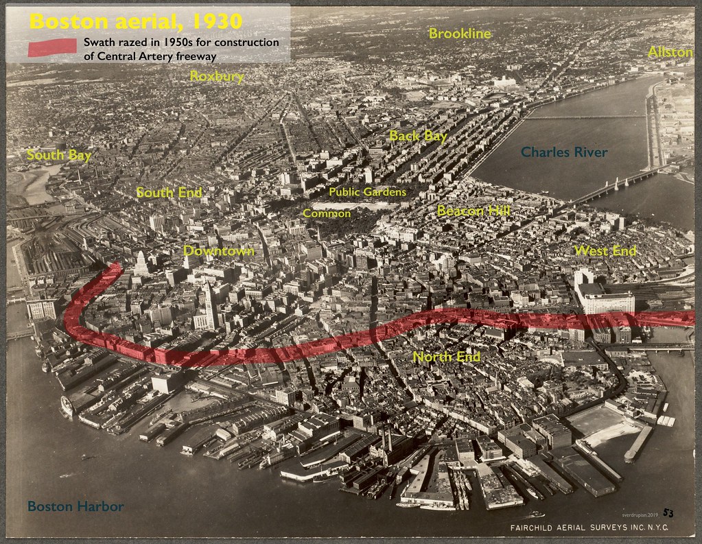
I found all these on google web searches. I don't know how to post them, but I'll post the links and you can click into them for the full size photos. The first one is a bit difficult to stomach.
- Joined
- Jan 7, 2012
- Messages
- 14,072
- Reaction score
- 22,797
I found all these on google web searches. I don't know how to post them, but I'll post the links and you can click into them for the full size photos. The first one is a bit difficult to stomach.
 Fb_u1xFx5yvYWlg5ISAlePT2cLQjd1xkXVqaQCd81_E by Bos Beeline, on Flickr
Charlie_mta
Senior Member
- Joined
- Jul 15, 2006
- Messages
- 4,561
- Reaction score
- 6,489
^ That first one showing the future elevated Central Artery swath through old Boston is priceless.
Since I’m probably not the only one who looked at that and wondered if they were seeing what looked like a beach in the North End ....
 northendwaterfront.com
Life on the Corner: The North End Beach – NorthEndWaterfront.com
 northendwaterfront.com
Ugh I hate seeing how much open space there still is out in the Seaport area! It will be siphoning off demand from the bigger potential projects downtown for decades.


