Assembly Sq <-> Casino Footbridge

Nearby at stations landing the upper hallway between the garage and the T stop used to be a people mover. But they got rid of the people mover section because it was too expensive to maintain.

If they built one here, unless Wynn maintained it the people mover would be broken 75% of the time.
 
If they're actually gonna build the bridge why not spend the additional money and top it with an automated people mover, similar to what downtown Miami has had for years.
We had one of those, just tenths of a mile away, at Wellington...a horizontal elevator from garage to station. Problem with those things remain weatherproofing (winter/rust) and maintenance. Replaced with the covered walk we have now.

The reality is that bike infrastructure is becoming nearly year-round. Hubway used to close Dec-Mar and now has decent patronage all winter.

The cost of a plow is going to be much cheaper than the cost of an APM.

If anything, I'd have argued they upgrade the bridge to be like Portland's bike-ped-transit bridge (and carry the Silver Line / Urban Ring)

COMPROMISE: Built it to accommodate low speed autonomous electric shuttles:
1-autonomous-shuttle-comparo-mar-2017.png
 
I do want to see this built but it is frustrating that if you want to walk from East Somerville to Assembly, you have to take your life in your hands at the crosswalks and deal with a rat infested filthy underpass. But hey, there's not as much financial incentive to properly connect a local neighborhood as opposed to a casino.
I know I'm like a broken record on this, but it boggles my mind.

How would you suggest better connecting the two neighborhoods? Not much you can do with a giant elevated highway in the way...

Genuinely curious, as I'm an E. Somerville resident who regularly takes the Mount Vernon St / Alfred A. Lombardi Way underpass to get to Assembly,... while not perfect, I can't really see how else they could do this. A giant bridge over i-93? I just can't picture how that would feel better.

Obviously burying i-93 in a trench and bridging over it that way (think how i-90 is thru Newton) would be best, but I don't think they can do that to i-93 due to it's proximity to the Mystic, and the fact that the highway would then be below sea level.
 
To bury 93 would be extremely expensive. There are many more worthy projects that the state should undertake before they touch that.
 
To bury 93 would be extremely expensive. There are many more worthy projects that the state should undertake before they touch that.

Not thinking of anything quite as major as that.

If money wasn't an option, something like the bike path bridge under the Zakem at north point park could work if it wound it's way from Stop'n'shop to Assembly.
Not expecting anything like that to happen tho.

They could clean up the Kensington underpass. Put in proper walls to denote a corridor, put in nice paving and good lighting, maybe paint murals on the walls. As for the traffic crossing, there are four lanes on the Stop'n'shop side and two on the Assembly side. They could build a pedestrian overpass for the four on ramp lanes on the Stop'n'shop side. This could feed in to the underpass.
So one pedestrian overpass over four lanes of traffic, leading in to a cleaned up and well lit Kensington underpass and then one 2 lane crosswalk.
This could be done for relative peanuts compared to what's being spent in the area.
 
Doesn't look like there's a lot of room to cram in an extra bridge level for crossing the western ramps. There could still be a footbridge with switchbacks for crossing Mystic Ave., but I feel that would be greeted similarly to the Magazine Street footbridge in Cambridge: people still run across the road because it's the shortest path.

However, some traffic calming on the westernmost and easternmost crossings could probably go a long way - the Mystic Ave/93 ramp split could be shifted southeast of the crosswalk and Bailey Rd. could probably be narrowed slightly. The middle crossing would be harder to calm, as it's coming from the left lanes of the Fellsway straight onto the interstate, but the new signal for the U-turn immediately upstream might help to slow things down a bit.

In terms of the underpass itself, some better lighting and maybe some artwork would probably go a long way toward making it better. It looks like the north end will always be fairly constrained as long as the 93 ramps remain as they are, but I would agree that there's still plenty of room for relatively low-cost improvements.
 
The newly proposed design was discussed at http://www.archboston.org/community/showthread.php?p=313807#post313807 before this thread was revived, and over there I wrote

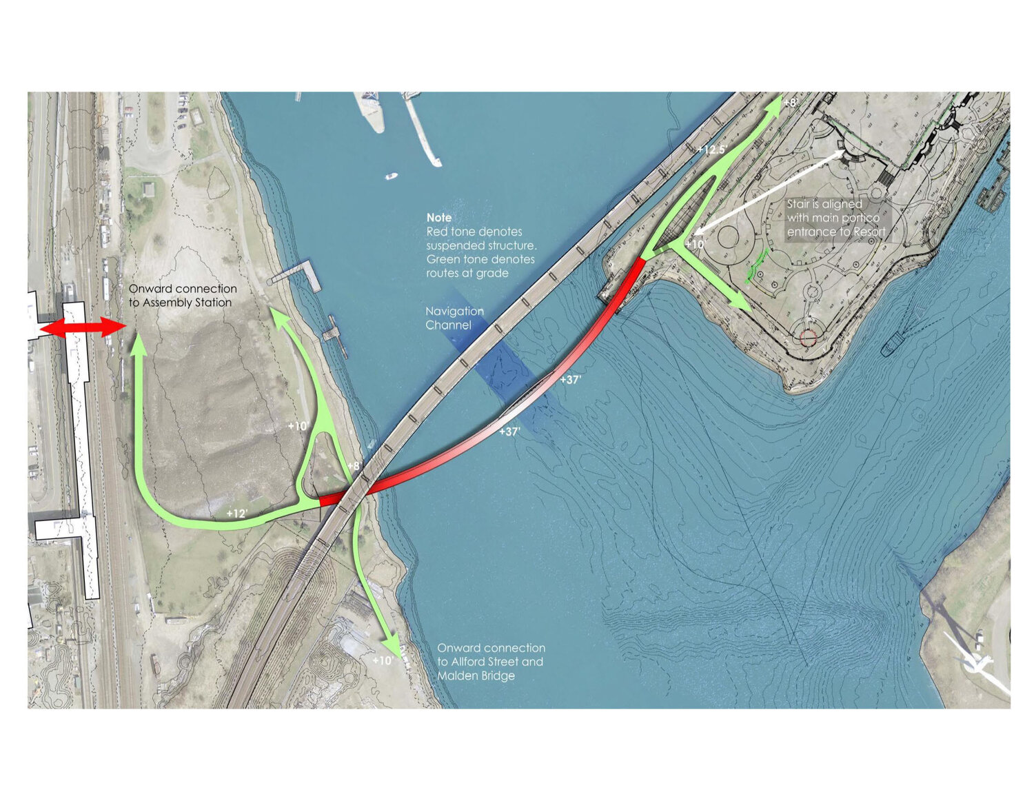
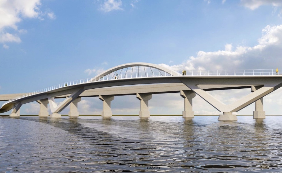
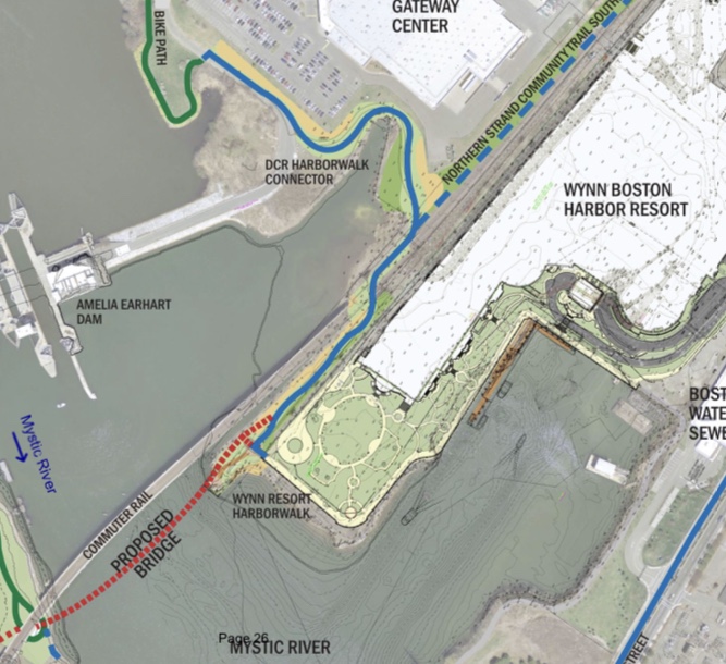
Am I understanding correctly that the proposed landing location for that on the north side of the river is the former commuter rail / freight bridge alignment, and so MassDOT and the MBTA (who are listed on slide 16 as stakeholders involved in this process) have apparently decided that they are committed to never building a replacement commuter rail and freight bridge on the traditional (apparently better) horizontal alignment with the new vertical alignment that removes the need for a movable span, but they didn't bother to explain that decision to the public in slides? I notice they didn't bother to include CSX and Pan Am as stakeholders in this decision. Can we get a statement from the freight railroads about how they feel about closing that option off and how happy they are with the current bridge's alignment?

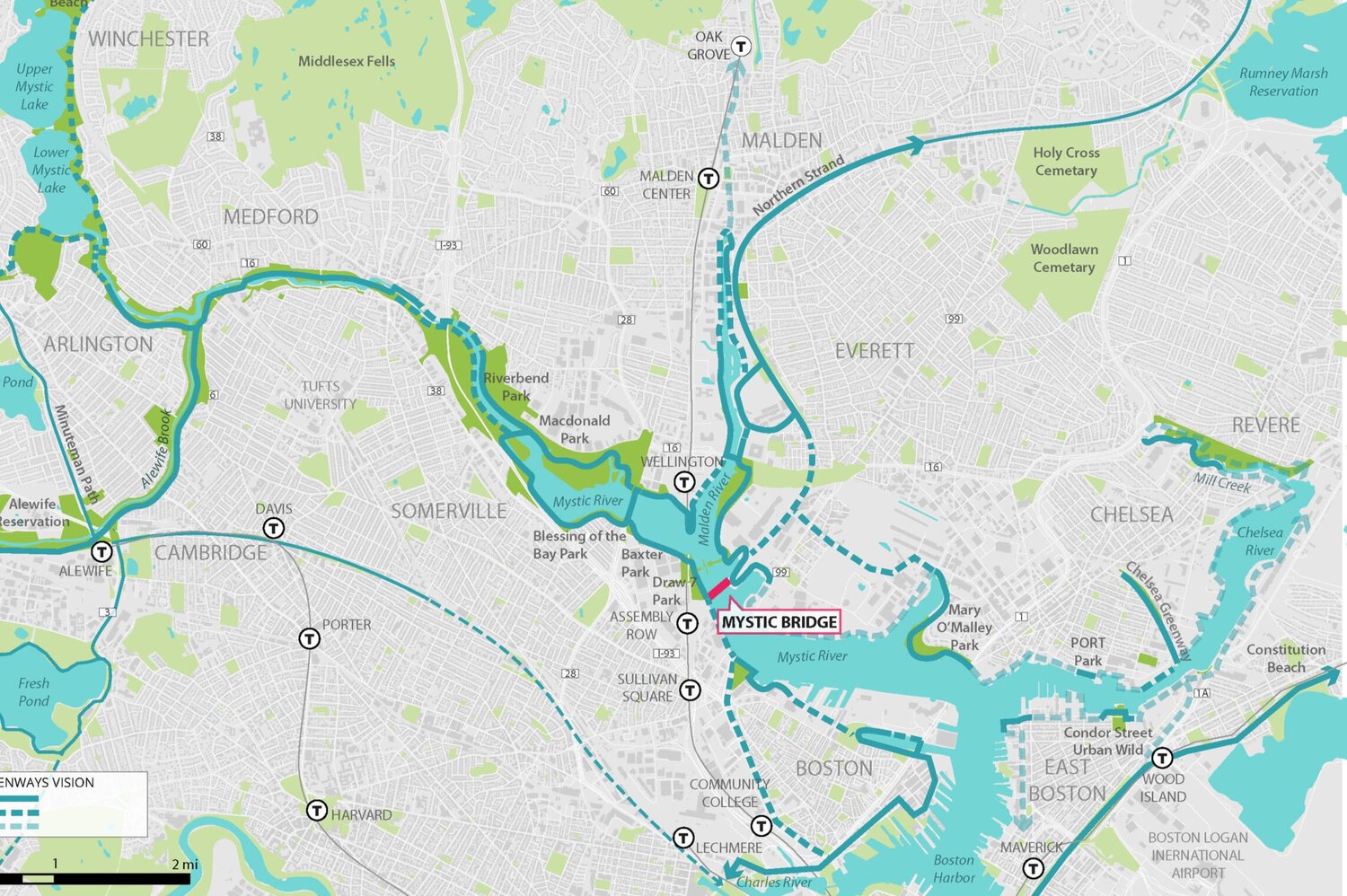
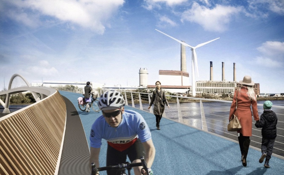
It's also interesting that they choose not to include the East Coast Greenway Alliance as a stakeholder. I was under the impression that the East Coast Greenway includes the Northern Strand Community Trail, and I don't see any plausible way that the East Coast Greenway routing would not end up including this bridge if it gets built. Of course, their ``Most direct route'' claim wouldn't hold for East Coast Greenway usage (but that's not necessarily a deal breaker; the East Coast Greenway's routing guidelines, last time I could find them on the website, claimed that most direct route explicitly isn't their goal).

And why do they think a Silver Line bridge is more likely than a Green Line bridge to actually get funded and built? (My preference is to get a new commuter rail / freight bridge built on the old horizontal alignment, then reuse the existing commuter rail bridge for Green Line maybe shared with bus and maybe with a bike path on the side.)

Also relevant is F-Line to Dudley's comment at http://www.archboston.org/community/showthread.php?p=229848#post229848

Look at Google Maps. The old Eastern Route drawbridge pilings and alignment are adjacent a couple hundred feet to the south, and there's a MOW spur on the Somerville side that's a remnant of the old ER mainline track. How this would work is you build a new fixed RR bridge on the old approaches, and put the UR on the existing bridge. The existing bridge has those steep grades and superelevated curve on it--mandatory slow zone because of the compromised sightlines, and murder on the locomotive engines (esp. the Everett Terminal freights) that wheeze over the top--because it had to be constructed that way to keep the old drawbridge in-service. The old alignment is WAY better for a non-curved and less speed-restricted bridge for RR service, even at much taller height than the old squat draw. A trolley or bus is much better at handling the grades of the current bridge (which is safely wide enough for buses if they install taller barriers). So...swap 'em. It matches up perfectly with the necessary track alignment for side-by-side RR and BRT/LRT, since the freight turnout to the terminal is on the south side of the ROW. No doubt it's expensive, but it's not totally the apocalypse with the recycled approaches shaving some not-inconsequential EIS pain and suffering off the top.
 
Globe: Who will pay for a $23 million footbridge to the Wynn casino?

Adam Vaccaro said:
The longest bike and pedestrian bridge in Greater Boston would also be its most expensive.

The proposal to connect the mega-developments of Assembly Square and the Wynn Resorts casino on each side of the Mystic River took a step forward last week, when state officials unveiled preliminary designs for a 780-foot footbridge — at a steep price of almost $23 million.

Now comes the hard part: figuring out who pays for it.

The government agencies involved in the project don’t appear in a hurry to volunteer, and although the biggest private beneficiary, the Wynn casino, is making positive statements, it also is stopping short of commitment.

The bridge would also require a separate project of $10 million or so to build a walkway over the train tracks to the Assembly Square Orange Line stop, a key feature that made it attractive to planners in the first place.

[...]

I get $23 million for the bridge over the Mystic, but another $10 million for a headhouse and bridge (of roughly 60 ft.) over the Commuter Rail? Basically the mirror image of this. A three story extension to a brand new existing building on terra firma with a couple elevators and escalators costs $10 million?

EDIT: On second thought, this might even be a stairs-and-ramps job. How is that $10 million?
 
Doesn't look like there's a lot of room to cram in an extra bridge level for crossing the western ramps. There could still be a footbridge with switchbacks for crossing Mystic Ave., but I feel that would be greeted similarly to the Magazine Street footbridge in Cambridge: people still run across the road because it's the shortest path.

However, some traffic calming on the westernmost and easternmost crossings could probably go a long way - the Mystic Ave/93 ramp split could be shifted southeast of the crosswalk and Bailey Rd. could probably be narrowed slightly. The middle crossing would be harder to calm, as it's coming from the left lanes of the Fellsway straight onto the interstate, but the new signal for the U-turn immediately upstream might help to slow things down a bit.

In terms of the underpass itself, some better lighting and maybe some artwork would probably go a long way toward making it better. It looks like the north end will always be fairly constrained as long as the 93 ramps remain as they are, but I would agree that there's still plenty of room for relatively low-cost improvements.

What about a tunnel underneath the highway on ramps on the stop n shop side? Is that too sketchy? Too expensive? Everyone is saying up and over why not down and over?
 

Option A for Draw 7 park looks pretty snazzy. Having a walking path around a soccer field on the water will become a really popular place to walk around for exercise along the new river walk.

Inflated cost of infrastructure aside... $23 million would be well worth the investment and the state is making enough money from the casino to easily justify that expense.
 
I think not turning the underpass of 93 along Ten Hills into a park is a decent missed opportunity for Somerville. An excellent local precedent is what Landing Studio did at Infra-space 1, which used to be parking lots and dead space under 93 at the Ink Block.
 
^Problem is that the underpass under a highway is never going to be an appealing area for people to walk around or hang out. Even fixed up it's still gonna be empty with only the homeless or occasional passer by using it.
 
Re: Highway Underpass Parks

Are you arguing that all the effort that went into the Lynch Family Skatepark was wasted and no one is interested in using that space?

In the short term I think there's a decent argument that we shouldn't necessarily be encouraging people to linger under highways where the air quality is poor, but in a decade or two when people have switched to EVs that should be much less of a problem (although there will probably still be a bit of particulate matter from rubber tires).
 
Re: Bridge to Orange Line connection

How does the elevation of the bridge at the center of the river compare with the elevation of the Assembly Orange Line headhouse where it crosses the tracks?

It seems like the option to put the pedestrian / bike bridge to the east of the commuter rail bridge forces folks coming from the casino to climb up high enough to let boats under them, then they have to go back down to get under the commuter rail bridge, and then they have to go back up to get across the tracks.

If we could find a way to attach a pedestrian and bicycle path to the northwest side of the existing bridge, it might be cheaper if we don't have to put any new supports into the river (depending on how much excess weight carrying capacity the existing bridge might have), and we also might be able to avoid having the path from the center of the river to the Orange Line headhouse across the tracks involve going down to go back up.

(Another question for that bridge: if we wanted it to carry 286k or 315k freight trains, how much upgrading would it need?)
 
^Problem is that the underpass under a highway is never going to be an appealing area for people to walk around or hang out. Even fixed up it's still gonna be empty with only the homeless or occasional passer by using it.

I see it differently. Its not a binary issue: i.e. its either appealing to hang out, or its empty and hostile.

The question is whether there are things that can be done to make it safer and more pleasant to walk underneath from one neighborhood to the other, and I think the answer is pretty obviously "yes". That those interventions might also make for more productive uses of the and and better maintenance impact for the structure (e.g. replacing salt piles with paid parking) are additional benefits.
 
... (e.g. replacing salt piles with paid parking) are additional benefits.

I was going to say then where are they going to store the salt... but openly storing salt under an elevated highway with lots of exposed steel is literally a recipe to cause premature failure of the highway. As we all know or should know salt increases corrosion of metals.
 
I dearly wish we were building a bike-ped-lightrail bridge (like Portland Oregon built).
I guess this one at least doesn't rule out F-Line's idea of a GL/UR bridge on the upstream side.

Also, I wish we saw (even in dotted lines) better cross-tracks access from the Assembly side (extending the T-Stops' structures and at least one from an Assembly building.
 
Methinks those renders are underestimating just a tad what wicked steep grades are going to be on that curved section. That's a LOT of elevation change between the slip-under of the Eastern Route bridge near Assembly and the navigation-channel peak. People are starting to kvetch about the Community Path kamikaze flyovers near Lechmere being awfully steep. They might not want to get a load of this until long after they've made peace with the GLX rampage.
 

Back
Top