Assembly Sq <-> Casino Footbridge

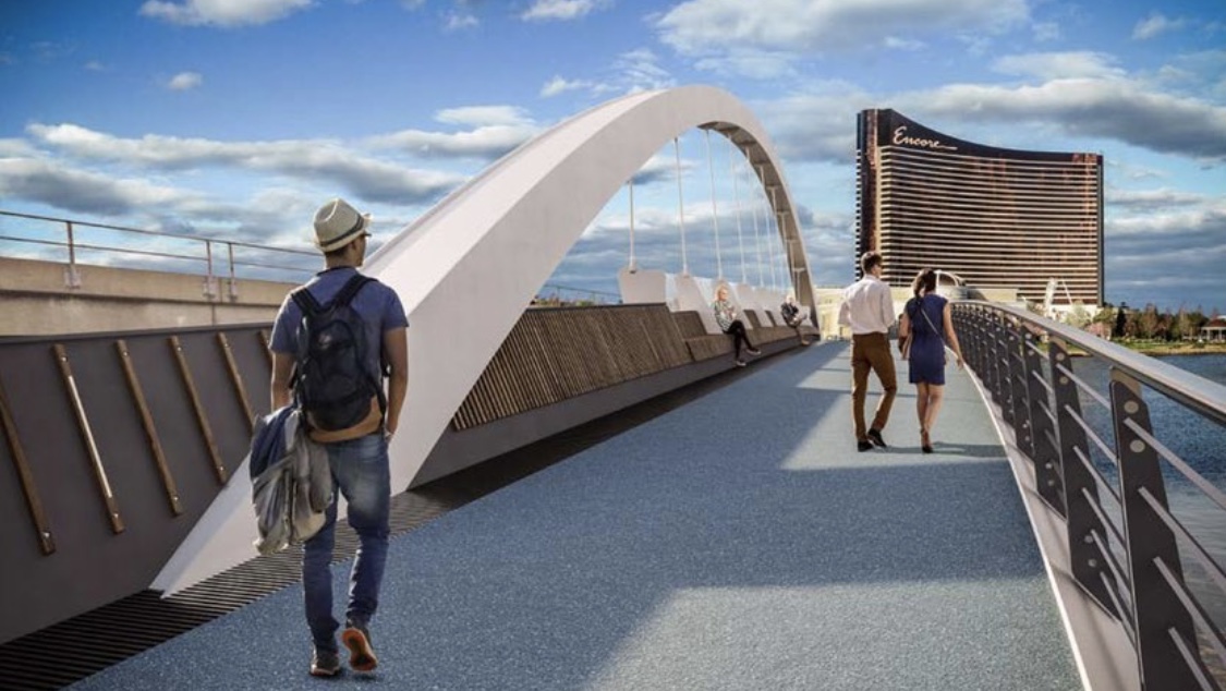
I dearly wish we were building a bike-ped-lightrail bridge (like Portland Oregon built).
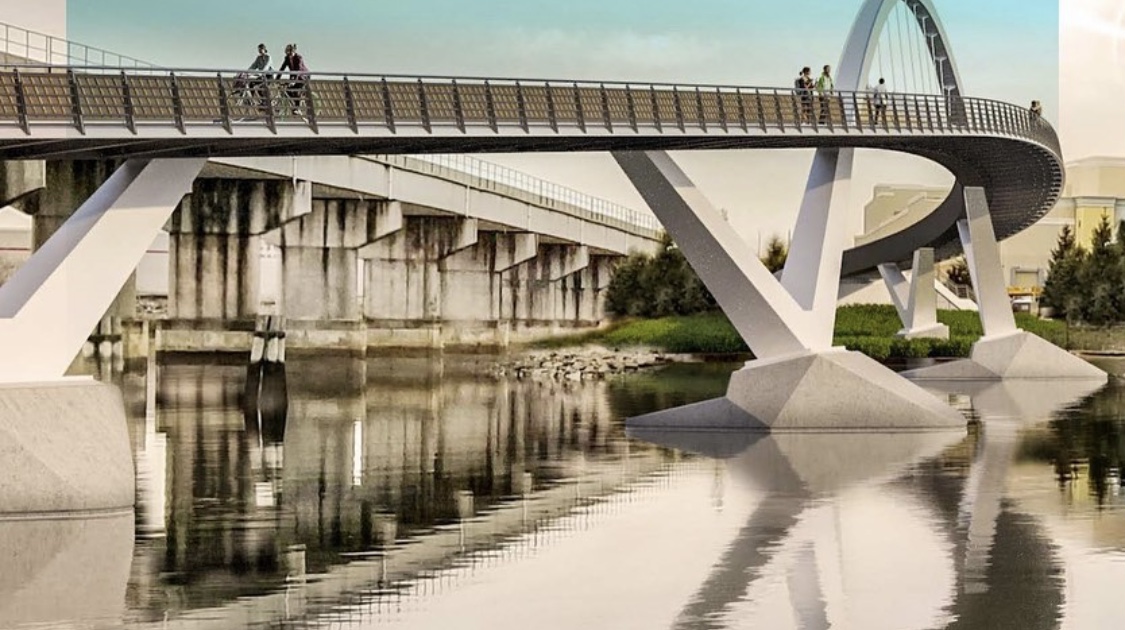
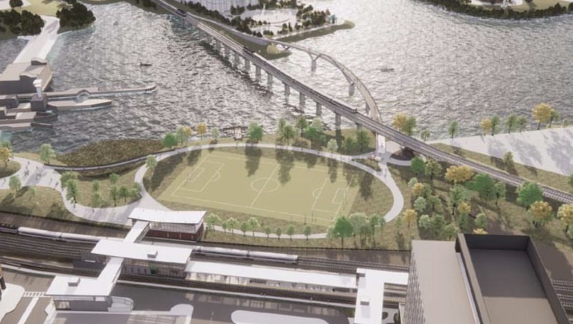
I guess this one at least doesn't rule out F-Line's idea of a GL/UR bridge on the upstream side.

It sort of does, because the easiest UR build would've been to plunk LRT/BRT on the existing bridge and move the Eastern back 100 ft. south to a straighter/shorter fixed bridge on the old Draw 7 alignment (since RR must land on the Everett shores on south half of ROW to accommodate the Everett Jct. freight turnouts). This footbridge gets in the envelope. Not fatally, but somewhat problematically. But not sure it's worth worrying about because (as in previous post) these grades are a lot steeper than they truly need to be to accomplish the job--and the grade is direct-exacerbated by the curve. So I somewhat doubt this is anything close to a final design since there are multiple different ways of doing this with less punishing rise.

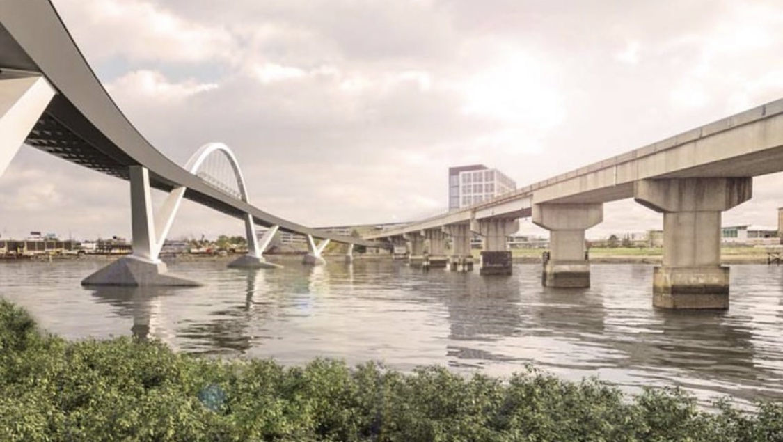
FWIW...the renders accurately depict how over-provisioned the '89 rail bridge is for spacing. Wide, wide track spacing and big fat emergency sidewalks the whole length of each side of the span. Most of that overprovisioning back in the original build was for Pan Am freights, because the utter gimp power they ran to Everett was so stall-prone over the peak grade that everything got overbuilt contingent on a crew being stranded near the tip of the navigational channel, having to put the whole train in emergency brake, and getting out to inspect on-foot before restarting. 3 decades ago it was their wet-noodle power 50-year-old GP9's that were the stall risk; today their GP40's assigned to Boston are intrinsically much brawnier, but just as old and decrepit at 48+ yrs. and liable to crap out by looking at it funny. Any company that ran like they gave a crap about finishing a schedule they started wouldn't be stocking such gimp power for a run through the middle of the commuter rail nerve center, and this wouldn't be a problem to begin with. But PAR, as we know, is not just any company. Fortunately/unfortunately they DO have a huge new influx of way newer/brawnier early-90's era CSX hand-me-down GE Dash 8's spreading through their power ranks. Only problem for Boston is that their biggest biz partners Norfolk Southern and CSX put the gun to their head to demand the non-gimp newer stuff on their big-revenue joint runs before anyone else gets the spoils, so Boston locals are still gerrymander-stocked with the oldest rolling ruins.

Were it not for that you'd be able to pack the tracks closer, and probably mash the two side sidewalks into one single-side double-wide bike/ped-worthy sidewalk separated from tracks by chain-link fence and have the path without needing to build any new spans. That, in a nutshell, is the logic of the LRT repurposing of the '89 span...you get a bonus path at no cost since the LRT tracks would be packed much closer, and making CR be the mode that changes spans sends it to over a more appropriately graded alignment for slightly faster RUR trips and no need for overwrought engine-stall precautions. It would be a good idea to at least *ask* if assessment is possible on re-packing the bridge, just on low odds that they get lucky on a favorable assessment and might be able to gain 'good enough' side path on a re-packed '89 span to gain the functional ped link without needing to build anything new. I'm fairly sure the answer is still going to be "No" because of the I.O.U.'s that Pan Am was given 3 decades ago for stall protection measures in the trade-over from the old draw to the replacement span. For all the years I've been following Mystic footpath talk (way, way pre-Encore) I can't recall any time the T was ever asked about those sidewalks on the span and how much overspacing was truly necessary vs. just a PAR-being-PAR hedge. Realism has to prevail, but asking point-blank wouldn't hurt on just the 0.5% odds of getting a lucky answer and maybe not having to build any new structures to accomplish this.


EDIT: To illustrate what I mean, the 1996-construction Neponset River CR bridge (itself a fixed-for-drawbridge replacement for the former draw span that burned down in the late-60's) has a slightly sub-28 ft. shoulder-to-shoulder width, while the 1989 Mystic Bridge is 33 ft. shoulder-to-shoulder due to the sidewalks. Both are officially-exempted from 1.5% max new-construction RR grades at 3% for Neponset and Somerville-side Mystic and 3% + fraction for Everett-side Mystic because they were both fixed-for-moving span replacements. Though CSX doesn't run any regularly-scheduled freight over their Neponset rights (then again, they also don't pussyfoot with woefully-maintained gimp power all places in MA where they do run). Main difference between spans is that the Neponset is arrow-straight with navigational peak near the center, while Mystic has the pronounced curve on the Somerville side and off-center navigational peak closer to the Somerville side. Not sure if the curve location exerts any role in the over-spread provisioning, or if you can simply chalk that up to a "Pan Am being Pan Am" provision.

So while you would not be taking any sort of luxurious-width path accommodations on a re-packed Mystic span with sidewalk fence-separated from RR it's dimensionally within the realm of feasibility to do on the as-is span if the advocates want to ask the point-blank question and fashion something sooner than any new span that by its wholly-new nature is going to be pricey. I suppose if you're going to be squeezing a 5 to at most 6 ft. width continuous sidewalk that you'd also be looking to dress up the length of the bridge with regularly spaced bulb-outs grafted on as structural overhangs so there's frequent-enough pausing/passing/lookout spots. But that's not a big production to swing because those wouldn't be load-bearing structures by any means.

Hey...can't hurt to ask. What's the worst that could possibly happen: "Can't do it because of X, and this bridge is different than Neponset's spacing because of Y & Z." Fair enough...move on to the next set of footbridge renders.
 
Last edited:
I found F-Line's proposed bridge setup in the Green Line Reconfiguration thread, and thought it worth illustrating here why putting a footbridge on the downstream side might not be a good idea, since it would sit right where a highly logical CR bridge would go. (the current bridge could also be Urban Ring BRT or autonomous shuttles before being converted)...the net idea is: build a better CR bridge and convert the one we have to other modes (including bike-ped)

As described above and pictured below, F-Line asked earlier why not use the current bridge for GLX + multiuse path (particuarly since you can put GLX tracks closer together than you could freight tracks)

urne-2-jpg.5066

That's the ultimate goal. So, really, the footbridge alignment just has to avoid getting too careless about veering into the clearance envelope of the old Draw 7 alignment (which is still, despite any temporary path structures on the Encore side, T-owned). Which can be done, since as before the current renders are a little more careless on the curve v. slope geometry than they truly need to be for an effective ped-only span...so add'l troubleshooting work is warranted with those renders to begin with.

Attractiveness for the UR build in making CR be the mode that moves is that the Draw 7 alignment is literally half the length of the 1989 span, which as you can see keeps going way out of view at top of the pic before ultimately touching down on Everett terra firma. Since it was built while Draw 7 was still in-service to the side, it had to be much longer and have the crummy performance combo of curve + steep grades in the middle in order to be built at all next to the active old span. The vacated Draw 7 alignment is waaaaaay cheaper to recycle than anything upstream, so mode flip is far and away the easiest means of getting the UR across the river. Plus given the over-wide buffering the '89 span is wide enough to take BRT without mods if it comes to that.


The current-events question is merely...given that the '89 span is so over-spaced for engine-stall contingencies while a direct-matching comparison of same lineage like the Neponset CR Bridge is not...would it hurt to ask the T right now for a workup of whether re-packing the CR tracks and sidewalks above is a feasible move? It doesn't necessarily have to wait for LRT conversion, because as the Neponset comparison shows this is an intentionally over-spaced job by RR standards with a known explanation (PAR freight stall contingencies) behind it. Could a re-packing reclaim enough space for a fence-separated path sidewalk on one side on the existing bridge...next to the existing CR mode...without needing to spend for a separate span's design-build? After all, Pan Am isn't as stall-prone today as the power they were running 30 years ago when the bridge first opened and won't be as stall prone in 5 years vs. what they are running today...so unless there's some irrevocable legalese I.O.U. to PAR those over-cautious stall provisions shouldn't be necessary anymore in 2020. Does that line of inquiry have any legs to possibly greenlighting a cheaper/faster solution? If not...we get a straight-up technical or legal explainer why the layout has to stay as-is, check that off the list, and move on to looking at more footbridge renders. No skin off anyone's back if it's a "No". I just don't believe that...ever, in the cumulative history of Mystic footbridge talk...any party has ever asked that point-blank question about the '89 span's layout. Doesn't hurt to be thorough.


If we get lucky and it is deemed possible (with due-consideration further investigation)...then we get a narrowish/imperfect but extremely $CHEAP$ and fast-trackable path that makes the connection while letting us apply the $$$ we were going to spend on a dedicated span to other meaningful connecting legs that immediately goose the whole path network's top-line utilization. And since it's imperfect (I mean, trains will be blowing loudly past on the other side of a chain-link), goosing the top-line utilization first makes a later second bite at the apple with a more luxurious dedicated footbridge a much easier funding proposition. So it kind of rebalances the whole bang-for-buck per individual funding wad vs. cumulative builds-over-time value proposition of the whole crossing-Mystic universe. Figure that if the resulting sidewalk width is kosher for accessibility that the aforementioned chain-link fence has regularly-spaced one-way alarmed emergency gates from trackbed to path replacing the evacuation functionality of the current double sidewalks. Suicide fence on the water-facing side of the path. And then do concrete-pour installation of 2-4 turnout overhangs (non load-bearing structures) regularly spaced along the bridge path as passing & lookout bulb-outs to segment out the fairly narrow contiguous path with repeating breathers to traffic-manage. If available and cheap, advance the discussion with a workup...in the likelier event that it's not available, at least you got the unasked question answered once and for all.


EDIT: Re: the Neponset v. Mystic bridge comparison, there's also one major ops difference between the two that is in active process of going away. New Neponset Bridge from Day 1 has been cab signalled, meaning if any train gets disabled from stalling on the grade the dispatcher can enforce all traffic around the bridge to stop dead at the nearest signal block so it's safe for the crew to get out and walk the other track to inspect or evacuate. Cab signals can be human-overridden only at sub- 10 MPH speeds, such as in the example of how a rescue engine would very slowly approach a Neponset disablement to push it safely over the hump. That makes it maximally fail-safe, as nothing is capable of approaching from either track without going so slow from such a far line-of-sight that crew on the trackbed have limitless time to get out of the way or hand-signal the rescue's engineer from afar. Northside--until PTC got turned on earlier this year--it was all- human obedience of wayside traffic light signals with no auto enforcement, and was possible to take the Mystic Bridge at-speed after blowing a red while a stranded crew was outside. Hence, the need for emergency sidewalks on both sides of the bridge. That era is over...PTC is now active, and northside is getting complete rush-install of the cab signal layer at long last so it has total fail-safe and dispatching parity with the southside for the first time in history. Lowell Line is the "demonstration" cab signal install on tight deadline for 12/31/2020 to the FRA. The others, including the Eastern, get granted a 2-year fed waiver for their cab signal installs if Lowell makes the year-end deadline. By start of 2022 the Mystic will be 1:1 as fail-safe as the Neponset for train crews or passengers being able to evacuate no-worries onto the trackbed or other track instead of onto a dedicated catwalk.
 
Last edited:
Why would they position the MBTA access on the north side, farthest from the potential customers coming over the bridge or from the new developments on the other side of the tracks?
 
Last edited:
Why would they position the MBTA access on the north side, farthest from the potential customers coming over the bridge or from the new developments on the other side of the tracks?

Only guess is to be further away from the floodgates or whatever those are. Plus it's on the casino side.
 
Why would they position the MBTA access on the north side, farthest from the potential customers coming over the bridge or from the new developments on the other side of the tracks?

I think you meant why is the new headhouse on the northern entrance and not the southern one? That's a good question - I was wondering the same thing and hope the MBTA changes course as the project progresses.
 
I think you meant why is the new headhouse on the northern entrance and not the southern one? That's a good question - I was wondering the same thing and hope the MBTA changes course as the project progresses.

OP's posting was confusing but I thought OP was talking about the bridge being on the Encore side of the CR tracks and not on the side where Home Depot is.
 
I came down the Northern Strand trail today and if there was a connection to this bridge it would have saved me a literal mile and a terror-trip through the Wellington Circle monstrosity. If anybody has Chuckie Baker's ear, tell them to drop F-Line's bridges into casual conversation. He's right on all counts.

Or if we need to go really cheap, throw some planks over the locks!
 
I think you meant why is the new headhouse on the northern entrance and not the southern one? That's a good question - I was wondering the same thing and hope the MBTA changes course as the project progresses.
I think the Assembly station southern overpass building to the Partners/MGH building is not designed for that extension, while the northern one has the punch-out already there where the fare vending machines are.
1635049009406.png
 
Side question, does anyone have an exact date for the south headhouse opening? It doesn't seem to have made it into the press when it happened.
 
All we need is 3 of these Rolling Bridges on the dam. Done.
Or if we want to be smart about the whole area, knowing we need a new dam built anyway, we take F-line’s bridge project and add it to that. 3 birds, one stone. One very expensive stone.
 
Last edited:
All we need is 3 of these Rolling Bridges on the dam. Done.

...and a way to get from Assembly to the park, walking paths up to the dam (the only access point is a authorized-vehicles-only road), and a path into the shopping center. All of which nets a long, winding route, none of which is currently covered (and it's entirely possible that a bridge like that London one couldn't fold up if it's roofed, though that's speculation on my part).

It's a fascinating article of engineering, but not, in my opinion, suited for this particular problem. I think that you're right that this could be a suitable design if the project brief was to cross the dam locks, but that's neither necessary nor ideal for this project. It's near enough an extra quarter mile walk (all of it outside and currently unprotected) to get to the correct side of the tracks from the current Assembly headhouse. That's never going to fly versus a quick bridge over the tracks out of the north headhouse, which is also a better starting point for a direct alignment towards the casino (and the shopping center) and doesn't impact a working marine facility. That said, I do wonder if anyone suggested a proposal like this to the Governor, given how much he seems to like cheap-but-less-than-awesome proposals (i.e. center-boarding GLX stations with no fare control, South Coast Rail off the single-track Old Colony main line, etc.)
Change the brief.
First, there are roads to the dam on both sides. Artisan to Noonan on the West and an access road on the East. All we’re missing is permission to rip down some rusty chain link fence and a nod to cross. Kick the Can Baker can low ball short term (a cheap path connecting the Northern Strand Trail to the dam) while planning the larger multi-jurisdictional craptacular mentioned above. This could be a temporary solution on the cheap while waiting a decade for the bells and whistles project to happen.
Give it soft permitting and tell the kids at MIT they have a budget of $200k and you’ll get something awesome that works for non-casino pedestrians and cyclists… this year.
 
bostonhardhat ig has some new renders


It'd be nice if it didn't eat so much of the alignment of the old Eastern Route bridge. It'd be a shame to have to tear it down if we ever wanted to build the Urban Ring as LRT through there (or, depressingly, knowing this state it'd be used as an excuse to kill any consideration of it).
 
Even calling it that is generous. It was a mowed field that saw occasional use before the pandemic, now it's basically where a pokemon trainer starting in Assembly would catch their first pidgey.
 
It'd be nice if it didn't eat so much of the alignment of the old Eastern Route bridge. It'd be a shame to have to tear it down if we ever wanted to build the Urban Ring as LRT through there (or, depressingly, knowing this state it'd be used as an excuse to kill any consideration of it).
MassDOT/MBTA should do some "futuring" here and build the future urban ring line and this footbridge as one bridge crossing the river. It can be used as a BRT route until the light rail is installed later.
 

Back
Top