Biking in Boston

Maybe it's just the nice weather we've been having lately, but the bike traffic on the Hampshire/Beacon corridor feels like it has reached another level lately. It has been super busy this week, even relative to normal busy standards.

Glad they're finally handling Beacon St next year.

I am glad too. I thnk the traffic is particularly impressive given the utility work (insitiform) pre-work on Beacon. It is clear that from Kirkland inbound that the bikes are moving more people each AM than the private cars in the "main" lanes do.
 
The "groundbreaking" on the Somerville Community Path extension from Cedar St to Lowell was May 2013......15 months of construction>>
 
The "groundbreaking" on the Somerville Community Path extension from Cedar St to Lowell was May 2013......15 months of construction>>

For the longest time it was a construction access road to the demolition at the MaxPak site, so they just bulldozed the earth around for the grading so the heavy machinery could get in. Are they actually finishing the real landscaping job now?
 
I'll try to snap some pics of the community path status. I pass it at least once a week on runs.

Current status is... there were apparently some soil issues (according to path advocates) and the project manager left last fall for school or something. Work picked up again in May 2014, a year after groundbreaking. Only real accomplishments at that point were some drainage work, leveling, and the start of a 20+ foot elevation to connect with Lowell Street for ADA compliance.

Most recently there's been a lot of concrete work. Poured foundations of the ramp up to Lowell Street, some steps and ramps from Maxwell's Green down to the path, and some funky concrete "squiggles" on either side for character. Recent pics from Friends of the Community Path here: https://www.facebook.com/Friendsoft...0.1409074490./754980671225408/?type=3&theater
 
Most recently there's been a lot of concrete work. Poured foundations of the ramp up to Lowell Street, some steps and ramps from Maxwell's Green down to the path, and some funky concrete "squiggles" on either side for character. Recent pics from Friends of the Community Path here: https://www.facebook.com/Friendsoft...0.1409074490./754980671225408/?type=3&theater

It seems to me they've let feature creep delay their launch, overdoing it with the doodads and wows.

Think how many more miles of paths--wider, farther, sooner--we could have if they weren't larded up.

The single "luxury" we need is wider paved areas--more like 10' wide instead of "sidewalk" wide. Beyond that, paint a yellow line down the middle and a bollard at each end and open more of them, not fewer gem-like ones.
 
Hell, there were crowds of people using the "path" on the weekends when the MaxPak demo construction workers forgot to padlock the chain link fence at Cedar. Great shortcut to Warwick St. even with the Lowell St. grading not yet complete. I went exploring down there one of those weekends the gate was wide open. Close to a dozen people passing through along the way on the gravel.


Before that...maybe not crowds because of the overgrowth, but there'd always be a few people walking the tracks to cut over to Warwick. Must've scared the shit out of them to go staring into the headlights of a weekday afternoon freight inching its way up the branch and listing scarily horizontal on that rotted out trackbed. They were getting regular deliveries as late as 2002-03 right when the plant closed.
 
It seems to me they've let feature creep delay their launch, overdoing it with the doodads and wows.

True, but I can understand the rationale for this particular quarter mile. Everything outbound is already done and can't be spruced up without impeding huge amounts of existing ped traffic. Everything inbound is hugging retaining walls and running along active tracks.

Somerville sees this segment not solely as community path but as a fully-realized park. I'd put money on it that this is where the traffic switches dramatically from dog-walkers and baby strollers to serious inbound bicycle commuters.

Yeah. The Lowell St. connection is absolutely critical for most direct-possible shots to Ball Sq., Medford St. to Gilman, the 80 and 89 buses at their convergence point, and a straight/one-street route downhill to Beacon St. because of the way Lowell direct-aligns with the Sacramento St. underpass at Somerville Ave. Cedar's not as intuitive for back-tracking around, and has more traffic than Lowell (which is striped for bikes). Every time I'd walk to Ball from my apt. near Alewife I'd crave that extra +1 block of completed path.

Utilization is gonna surge bigtime when that seemingly inocuous little extension opens.

I'm not sure I follow. If you were walking from Alewife to Ball Sq, why would you be near the future Cedar-Lowell stretch of the SCP? You'd just hang a left on Willow, no?

I don't see this having a big effect on bike traffic. The Lowell extension of the SCP will be popular with dog-walkers and pedestrian traffic, but it leads bikes into the "valley" between Winter Hill and Spring Hill. Unless you are going to Gilman Sq, East Somerville, or that residential area, I'd imagine bike traffic will avoid that part of the SCP until the full extension to the Charles is built.
 
Not sure if it's been posted, but as of summer 2014 the T has added a third bike cage at Alewife. This means there are a total of ~800 bike parking spots and 2300 auto parking spots, a pretty good ratio for the US.
 
This is a message fron NYC DOT (via www.looknyc.org) is for both drivers and cyclists:

desktop-1409253747.png
 
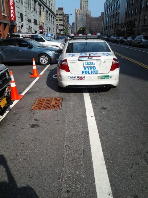
I would be more impressed if they published a photo of an NYPD cruiser parked in the bike lane.

tumblr_mtquhcfQ0w1sjcsu0o1_500.jpg
 
Cruiser in the bike lane and it looks like cars also parked on the sidewalk.
 
On Friday (Sep 5) a Somverville cyclist was killed on Rt 16 in Medford near I-93 (which describes two intersections--an "on" and an "off" and about a half mile in-between). See this Medford Patch blurb. But basically, it occurred in one of the few places that a Somerville Cyclist can get across the Mystic River.

Today we have the names released, but no details. I really wish they'd release more of the "geometry" or "root cause" details so that everyone--cyclists, motorcyclists, motorists--can do more to ensure that such fatalities are learned from and avoided in the future.

Ordinarily, I oppose "morbid" local news, but to me this is more like the "accident movies" they show(ed) in Driver's Ed: important if we are to take seriously these deaths and learn from them.
 
I'm going to assume it was here, which looks like the same kind of batshit crazy deathtrap of an onramp that keeps killing people in Allston. Cyclist was probably using the paths and got run down by the motorcycle getting onto the Mystic Valley Parkway.
 
Grrrr. Worse yet, the cyclist was probably heading to the bike paths along the river. These sort of "last mile" black holes for Boston biking are literally killing people.
 
I'm going to assume it was here, which looks like the same kind of batshit crazy deathtrap of an onramp that keeps killing people in Allston. Cyclist was probably using the paths and got run down by the motorcycle getting onto the Mystic Valley Parkway.

And, in general, there's waaay to much asphalt here, that's proved near-impossible to narrow/calm. So people do floor it as they "enter" it (from both I-93 and 16 westbound). That ramp is 2 lanes (and the overpass on 93 is 3 with full shoulders) because it is the built "interstate-overpass" section of an unbuilt inner beltway(that was designed for volumes going from I-93, along a widened 16 (which has since been narrowed, thank goodness), and connect to a full-freeway US-3 up the Mystic River/Mystic Lakes to Rt 128 in Burlington.

I spoke with Sen. Pat Jehlen's office about this area and they were very sympathetic about the idea of narrowing it (and even giving some of the asphalt & bridge to multi-use paths) but mostly despaired of change because of the patchwork of stakeholders (the worst being the federal government that does not like to see its Interstate elements reduced). But it is a mix of DCR, MassDOT, Interstate, & City of Medford.

Given that the other vehicle was a motorcycle, the other cause I thought of was that they were both trying to pass cars on the right somewhere on the western side of I-93--or both doing the same "make a lane" and the motorcycle ran the bike down from behind, such as on the offramp/parkway merge on the other side.

One things we can do is work harder to get the Mystic path system from designed to built.
 
But basically, it occurred in one of the few places that a Somerville Cyclist can get across the Mystic River.

Very, very sad story. I feel awful for the cyclist and his family and friends, and frankly the motorist who now has to live with what he did. It was more likely a product of the road than the cyclist's actions or the motorist's actions, knowing the area. Here is my take on crossing I-93 and the Mystic River in this area:

This has posed a major problem to me when trying to bike to Everett/Chelsea/Revere. I always begrudgingly took public transportation or didn't make the trips.

My options, between Medford Square and the Logan Airport ferry:

  • Alford Street, Charlestown-Everett. This was still under construction most of the summer (I think), but has since opened with apparent bike lanes and sidewalks (Alford Street Bridge Opens). I'll have to reserve judgement until I try it out, and I hope this was a big improvement, but it previously was a frightening place to bike that I always avoided.
  • Fellway, Somerville-Medford. A 6-lane highway that I will not bike on for obvious reasons.
  • Mystic Valley Parkway, Medford. A highway that has sidewalks. I would ride on the sidewalks, but not on the road. And I am an experienced cyclist who mostly refuses to ride on sidewalks, except where necessary.

tl;dr: I honestly hope Alford Street is bike-able now, as the next best option for crossing the Mystic is the sidewalk on the Mystic Valley Parkway (Route 16) near where this cyclist was killed.

The other problem, the one this poor cyclist faced, is that I-93 poses a barrier equal to the Mystic River. For example, getting to the sidewalks on the Mystic Valley Parkway bridge requires crossing I-93. Your options between the Mystic River and Charlestown are:

  • Mystic Valley Parkway, Medford. Crossing under I-93 on the Mystic Valley Parkway is not something that should be done outside of a car. This crossing is dangerous by foot or by bike. Your options are to use the narrow sidewalk next to highway-speed traffic or seriously risk your life, as shown today, very sadly. The overpass that's farther north is even worse. I'm pretty sure non-motorized traffic is banned from that section. If it is not, it should be. This stretch is a high-speed, multi-lane tangle of interstate on- and off-ramps.
  • Shore Drive, Somerville. Hard to get to on Mystic Ave (a quasi-highway). Once there, the underpass is unpleasant, but do-able, with short sight lines and blind turns.
  • Temple Rd, Somerville. My go-to crossing. This is the only one I've used more than once. It's an unpleasant underpass that has short sight lines, but is easier to get to and the least of the evils.
  • Bailey Rd, Somerville. One-way west bound and is treated mostly like a highway on-ramp. To be avoided on bike or foot.
  • Assembly Square Dr, Somerville. There are token bike markings painted on in one direction. Speedy car traffic, little-to-no shoulders, multiple turning lanes for cars. Better than Bailey Rd, but I certainly didn't feel safe biking through the one time I tried it.
  • Google maps shows one crossing under 93 that is a windy pathway. I've never seen this and am unsure if it actually exists, but seems like it would, best case scenario, amount to biking on a narrow sidewalk.

tl;dr: From Sullivan Square to the Mystic River, there is one, or maybe two okay places to cross I-93 in Somerville (Temple, maybe Assembly Square Dr) and ZERO safe places to cross on bike in Medford.

THE BIG CONCLUSION: To get across both of these barriers (I-93 and the Mystic River) safely from Somerville, North Cambridge, or the southern part of Medford, one would need to:

A. Go down and around through Charlestown and over the Alfrod Street bridge.
B. Go under 93 on Temple and back-track a mile on the Mystic paths to ride on highway sidewalks on the Mystic Valley Parkway bridge.
C. Go up and around through Medford Square.
 
Yeah, the 93 barrier is a large reason I refuse to move to Somerville from Brighton. I considered moving over there this year because a few of my friends are, but after spending a few days biking around: no way.

Grrrr. Worse yet, the cyclist was probably heading to the bike paths along the river. These sort of "last mile" black holes for Boston biking are literally killing people.

How much you want to bet it's a DCR intersection?

I go a third of a mile out of my way to avoid a similar black hole death trap. Even so I have to negotiate two terrible intersections that were barely designed for pedestrians, and defiantly not cyclists. I had a bit of fun annotating my two inbound commuting options.

To Arlington's point, I think cyclist fatalities, especially due to poor intersection design, should be getting a ton more press. MassDOT has a lot of offenders, but the worst by far is the Department of CONSERVATION and RECREATION, which seems to really only care about spending its budget repaving highways and rebuilding medians. The Charles River paths have the same frost heaves and ball-crushing utility patches (I'm looking at you, BU Boathouse) as when I started riding seriously four years ago. And they obviously haven't spent a dime redesigning intersections to allow their users to actually get across to access their facilities, unless they are in a big steel cage.

I was REALLY upset with the press when that kid got killed in Allston by the Pike ramps. In the winter at a community meeting MassDOT swore up and down they were going to restripe the whole thing and put up bollards to temporally fix it "at the beginning of the summer". Half the meeting was residents asking/begging the DOT to do something about it immediately. Summers over, a kids dead (and god knows how many close calls there have been), and not a single thing has changed. That should be a front page story, everyone loves a good negligence piece.
 
Speaking of which, another meeting: Sep 18th, Jackson Mann. I think the BSA is going to do a presentation of architects' work just prior to it, too.

If you're right about the location then that arrangement looks similar to what the city is planning for I-90 onramp... so not good.

This crash should emphasize that the on-ramp must be (a) a single lane, and (b) with some kind of signal.

Oh, and DCR is a completely worthless fuck-up of an agency. A thousand times over.
 

Back
Top