It was added a few years ago because the square's main bus stop is there.
Not just that but also the main ped flows are across the square rather than along the edges. I mean that Dunkies on the corner, right?

It was added a few years ago because the square's main bus stop is there.
When people say a crosswalk is "too close" what is the standard they're using for "far apart enough?"
Bluebikes are now active in Newton, Watertown and Arlington, they also launched new stations in East Boston and at MIT this week, East Boston now has pretty full coverage and when Chelsea and Revere come online (supposedly in the next few weeks) there will be some great connectivity between them.
Is this one of those Fiscal Year anomalies? Money for expansion becomes available in September or October?Great news, but they need to adjust their timing so every single expansion is not scheduled for fall.
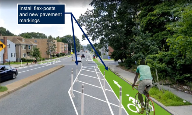
The city is moving ahead with the Cummins Hwy redesign which includes permanent protected bike lanes.
Cummins Highway narrowing and bike lanes to be extended from Mattapan into Roslindale this month
A city pilot aimed at making Cummins Highway safer by reducing the number of lanes from four to two and adding dedicated bicycle paths will be extended from Wood Avenue to American Legion Highway by the end of the month - as the city looks at more permanent changes along the thoroughfare - a...universalhub.com
I've ridden the pop-up lanes and they leave a lot to be desired, but mostly because they are easily violated by parkers. This proposal should be much better. This, combined with the similar plan for American Legion Hwy forms the missing link between the SW Corridor/Washington bike lanes and the Blue Hill Ave. corridor (along with the Neponset Greenway). This is what a networked route system is supposed to be.
There is a ton of info here, here's the design plans for the permanent changes to the roads in downtown to add bike lanes around the common/garden. https://storymaps.arcgis.com/stories/153b31bf6e7940c2820d67d983b9a931?utm_source=Transportation+&utm_campaign=2020-1008+Plans+&+Office+Hours&utm_medium=email
I'm impressed by the promptness of work. Most painting/lane changes will be done by the end of next month, and barrels will remain until flex posts are available. Signals will be altered to the new system by the end of fall, it sounds.
Unfortunately, drivers pay no attention to paint in this town. When the flex posts go in, they'll start to get it. I'm seeing the exact same issue with the lane reconfigurations happening on American Legion and Cummins Hwy. I get what they are doing, because I follow the projects and as a regular bike rider understand the purpose. But nobody else will get it at all until those posts form a quasi-physical separation.I couldn't tell what was going on when I saw the new lane markings when I was walking in. It is a little more apparent when you see it from above like this, but as you can see from the cars, they can't tell what to do either. Right now the cars are treating this new bike lane as a too small vehicle lane.
Unfortunately, drivers pay no attention to paint in this town. When the flex posts go in, they'll start to get it. I'm seeing the exact same issue with the lane reconfigurations happening on American Legion and Cummins Hwy. I get what they are doing, because I follow the projects and as a regular bike rider understand the purpose. But nobody else will get it at all until those posts form a quasi-physical separation.
There is a ton of info here, here's the design plans for the permanent changes to the roads in downtown to add bike lanes around the common/garden. https://storymaps.arcgis.com/stories/153b31bf6e7940c2820d67d983b9a931?utm_source=Transportation+&utm_campaign=2020-1008+Plans+&+Office+Hours&utm_medium=email
I guess maybe the issue is finding a safe way to split off the bike lanes that way.