Bowker Overpass replacement?

Data -- there are theoretical ideals and then there's -- "Close enough for practical purposes" there are a whole bunch of gnurdly non-PC jokes with that theme

Today, almost all of the interchanges along Rt-128 where its overlaid with I-95 / I-93 wouldn't make the grade these days -- there's no where near enough distance to accommodate the hgih density on/off ramp traffic -- Poster Child being I-93/I-95 in Woburn where 350,000 daily vehicles are shoehorned into infrastructure designed for 100,000

So in that guise I suggest a long-time-ago LA Freeway solution to dense interchanges needing additional ramps -- "the Disappearing Exit Ramp"

Driving along with multiple lanes in parallel and suddenly you see a sign overhead of say lane 4 from the right that looks like a Hermaphrodite Libneration Symbol and translates into --- "Merge L/R" -- The lanes to the Left will continue unaffected while those to the right eventially exit to local streets.

However, the lane that you are on is about to exit --- not to the left or right -- but to descend to merge with the Freeway below

Mean while just after the Descending Ramp* -- the void in the Freeway structure is re-occupied with an Ascending ramp which rises and eventually merges from the left with the lanes to your original right

I suggest that the Pike could support exits and entrances in the same fashion with just some tunneling needed to make the connections

* Note that we have our own version of the "Disappearing Ramp" -- just in front of Mass Eye and Ear -- Storow Drive just ascended from its E-bound tunnel splits with the two left-most lanes descending into a tunnel connecting with the bridge to I-93 N

Meanwhile the Right-most lanes are joined from their right by traffic from Leverett Circle and the whole eventually moves to the right to occupy the space previously occupied by the descending lanes enabling the L turn onto Obrien Highway by the old Lock and several right turns to I-93 S and local streets

First off...Storrow isn't a freeway. It's not bound to interstate standards.

Second..."disappearing" ramps are exactly the kind of left-lane sightline break that's dangerous for high-speed traffic and pretty much verboten by new interstate construction unless there is one hell of an airtight reason that it must be. Things aren't supposed to "dissapear" from the sightlines in the high-speed lane. Most definitely when the left-lane truck prohibition has to get dropped because it's an exit or entrance lane. That's not going to work. The FHA's going to have a very big problem with that on a divide-by-10 transcontinental two-digit interstate.
 
No. Impossible.

1) Anywhere near the Muddy River is a nonstarter.

2) Anywhere near Kenmore is a nonstarter because of the Green Line tunnels passing below.

3) There's a whole lot more groundwater than just the Muddy, so it's unknown what else could be a blocker.

4) 2.2% is the FRA maximum grade you can have for a RR incline without a waiver, and it's preferably less because that's going to slow a big 6-car diesel pulling out of Yawkey to a crawl. 16 ft. is the minimum tunnel clearance. So you need at least 800 ft. of runup on each side to do it. That's 1600 ft. Plus some leveling out at the bottom of the tunnel. Where is that space available around here? Measure on Google Maps between any 2 bridges west of Beacon (GL tunnel), Brookline Ave. to Charlesgate, Muddy River bridge to Boylston. I can't come up with more than 1400 ft. between any bridge pair.


Fatal blockers. So we're back to Mountfort/Carlton and a BU Bridge intersection reconfig as the only option.

I'm going to throw this out as I made this while you replied to me. This is throwing the kitchen sink to squeeze as much space as possible. Also, raised below, theoretically address your points (Green Line goes below Muddy river and each side of the incline can be more than 800 ft. If I am understand correctly of your 3rd point). If this doesn't give enough space, I'm out of ideas and I'll stop. Except focusing only on Carlton St. of course.

pKWnDXM.jpg


I would modify the image, to try and to try to accommodate your recent post to me, but I would have to start over and I presume it would still remained flawed anyways. I'll just describe below.

Purple dashed line - Measuring on Google maps, the east-of-Bowker incline have 800-900 ft of incline going down fully roughly before Charles Gate E. You said I need at least 800 ft each side, right? Would starting the incline from Mass Ave enough? Can the incline start under Mass Ave or earlier? For the west-of-the-Overpass, 1200 ft incline starting somewhere after Brookline Ave?

I know this doesn't address point 1 or 2 with the Muddy River. But doesn't the Green Line also goes under the Muddy River? I know it have armies of pumps keeping that going, but doesn't that also that means it's not impossible?

Orange lines - I moved the bridge west as possible and lengthen it southward. Yes, this is taking some land from the gardens. I'm hoping this allows space for Ipswich to continue to have a connection with the rage of the community gardens better than the rage of the Red Sox, nightclubs, MBTA, and a whole apartment building.

Pink line - I figured to throw it in for people north of the Pike who wants to use the "theoretical ramp".

Red line** - The eastbound ramp. From what you said, I should shorten it after the purple dashed line needs more incline. I don't have numbers of how long a ramp needs to be, current readings from this board says somewhere more than 12 ft wide. But assuming the railroad incline can start from Mass Ave at the earliest and giving a little more than 800 ft. I should have remaining somewhere from 200ft to 300ft... Wikipedia says the very minimum in an urban area is 100 ft.

**"But wait there more!" - Use the "Take half of Ipwich St." for even more space?

Light Blue Line - Unlike the previous idea, it is now staying connected. Maybe pulling back south is not even needed given the theoretical buried tracks. But since this is the kitchen sink idea for maximum space. I added this for more ramp space.

Gold blocks - reclaimed land to make up for loss for Southern End land taking.

Green Line - Western Off ramp into Newbury St. Unlike the others, I believe this is actually a real proposal being considered. So even if I'm doing it wrong, the state have a realistic version.

Light Green - Newbury St.

Orange Line connecting to Newbury St. Allows westbound off traffic to turn left and go Southward per traffic data report.
 
I'm going to throw this out as I made this while you replied to me. This is throwing the kitchen sink to squeeze as much space as possible. If this doesn't give enough space, I'm out of ideas. Except focusing only on Carlton St.

pKWnDXM.jpg


I would modify the image, to try and accommodate your recent post to me, but I would have to start over and I presume it would still remained flawed anyways. I'll just describe below.

Purple dashed line - Measuring on Google maps, the east-of-Bowker incline have 800-900 ft of incline going down fully roughly before Charles Gate E. You said I need at least 800 ft each side, right? Would starting the incline from Mass Ave enough? Can the incline start under Mass Ave or earlier? For the west-of-the-Overpass, 1200 ft incline starting somewhere after Brookline Ave?

I know this doesn't address point 1 or 2 with the Muddy River. But doesn't the Green Line also goes under the Muddy River? I know it have armies of pumps keeping that going, but doesn't that also that means it's not impossible?

Orange lines - I moved the bridge west as possible and lengthen it southward. Yes, this is taking some land from the gardens. I'm hoping this allows space for Ipswich to continue to have a connection with the rage of the community gardens better than the rage of the Red Sox, nightclubs, MBTA, and a whole apartment building.

Pink line - I figured to throw it in for people north of the Pike who wants to use the "theoretical ramp".

Red line** - The eastbound ramp. From what you said, I should shorten it after the purple dashed line needs more incline. I don't have numbers of how long a ramp needs to be, current readings from this board says somewhere more than 12 ft wide. But assuming the railroad incline can start from Mass Ave at the earliest and giving a little more than 800 ft. I should have remaining somewhere from 200ft to 300ft... Wikipedia says the very minimum in an urban area is 100 ft.

**"But wait there more!" - Use the "Take half of Ipwich St." for even more space?

Light Blue Line - Unlike the previous idea, it is now staying connected. Maybe pulling back south is not even needed. But since this is the kitchen sink idea of maximum space. I added this for more ramp.

Gold blocks - reclaimed land to make up for loss for Southern End land taking.

Green Line - Western Off ramp into Newbury St. Unlike the others, I believe this is actually a real proposal being considered. So even if I'm doing it wrong, the state have a realistic version.

Light Green - Newbury St.

Orange Line connecting to Newbury St. Allows westbound off traffic to turn left and go Southward per traffic data report.

You can't tunnel under the Muddy. Or rather, if you did want to tunnel under the Muddy...you must go more than twice as deep. That kills all the available runup space dead. No further options. And this is the fatal blocker where the ramp proposal dies.

Green doesn't go under the Muddy, but Fenway station abuts it and there's underground channels that saturate the D ROW. When the Emerald Necklace floods, the D portal ends up one giant bathtub train. Different water risk.

You still have problems on the map with the angle around the Trans National Building. It's tight. For example, a parallel street to Charlesgate E. would have to bend back on itself like this to reach around the building:

28smvmb.jpg


You can see how that's not going to work for facilitating any cross traffic when the angle around the building from the front walk is more like 75-80 degrees than 90 degrees. And on a slope, too, so Ipswich effectively gets turned into an alley instead of a thru street and the 55 bus must find a new routing.


But still...no amount of shifting of roads here allows you enough runup to shift the Worcester Line more than 1-2 feet before it has to get back on alignment, which is way too little lateral give at way too short a length to offer up an entrypoint onto the Pike. You dead-end at the same problem as before: must claim 1 lane each on both directions of the Pike and completely shift bridge abutments. Boom...9-figure project.

Because the tracks can't be shifted, ^^that^^ is the dead-end that fells each and every proposal at every bridge except Mountfort/Carlton where the tracks have buffer and runup space to shift.
 
Following up on CSTH’s original comments yesterday about identifying a comprehensive planning strategy for Bowker. I also welcome all the hardwork put in by Davem, CSTH, kenmore and ant to propose alternatives.

The goal of this post is to promote a vision of a comprehensive planning process as well as show the analytical framework for this process. To do this, I will address the Bowker in a larger planning context with six overlapping planning areas:
1. Bowker - existing roles and usage
2. Future demand and development – Allston, LMA, Seaport
3. New Back Bay Ramps – BU to Prudential
4. Pike Allston Interchange
5. Public transportation – Urban Ring, bus system, Allston / Watertown LRT or DMUs
6. Future of Storrow Drive

1. Existing Roles and Usage
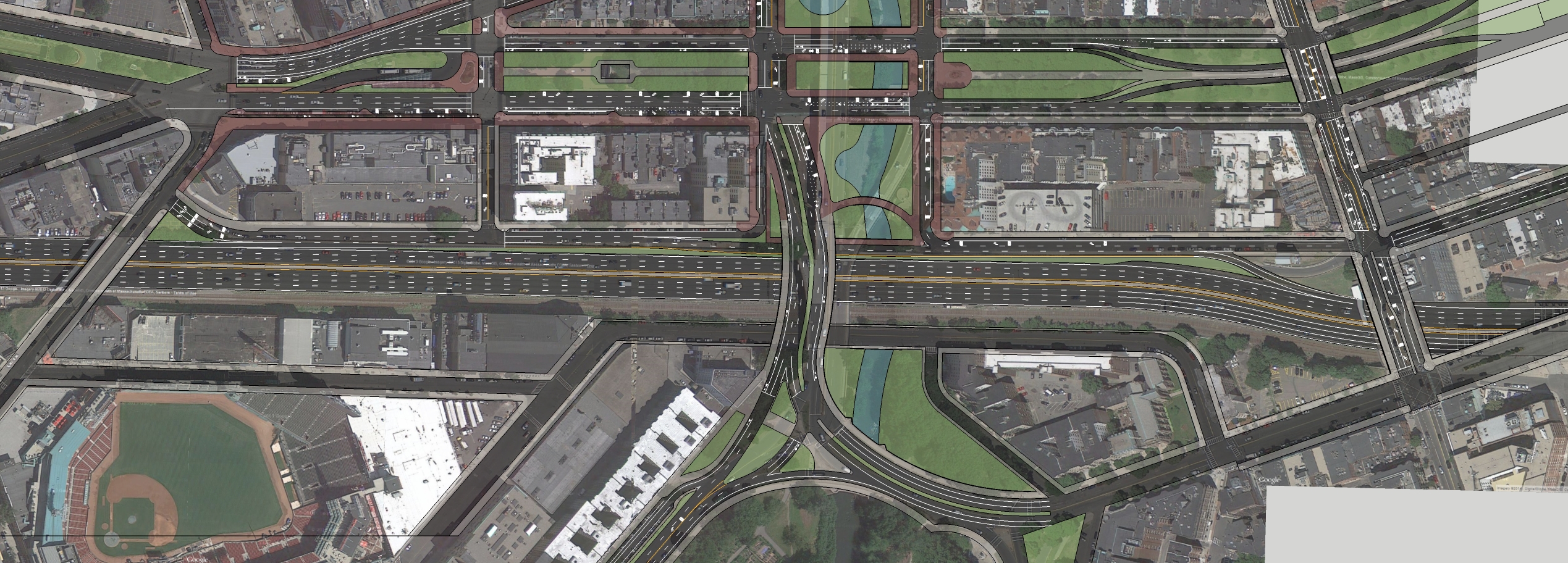
The Bowker overpass serves as a key node on Storrow Drive (SDr*) with respect to commuter traffic carrying approx 52k (2011) vehicles per day. This total is already 15% lower than 10 years ago. Usage is weighted approx 1.2 to 1.0 coming from the North versus that coming from the South. I estimate that 40% to 50% of SDr trips come through Bowker either direction. Its future is entertwinned with SDr itself.

The Bowker is the main node of a Y-junction connecting the Southwest Corridor (and Mass Ave) through Storrow Drive to Fresh Pond Parkway in the west and Boston West End / Leverett Connector (I93, Tobin, Logan) in the east.

The Bowker serves the following key roles:
A. Commuters north of the Charles River going to Longwood & Fenway, the Southwest Corridor (SWC), Northeastern University & Prudential and Mass Ave corridor & BU Med
- Northwest catchment from Rts 2 and 3 (Fresh Pond Pkwy) and Mass Ave Cambridge using (SDr eastbound)
- Northeast catchment from I-93, Tobin and Sumner (SDr westbound)

B. Commuters south of the Charles River going to Beacon Hill & West End/Garden, Logan, Tobin, I93 and Fresh Pond / Watertown / Cambridge.
- catchment from Rte 9, Jaimcaway, Columbus Ave and Mass Ave

C. Alternate route to the Mass Pike / Central-Artery for travel between LMA, Kenmore / Hynes and Harvard Sq, and East Boston / Logan, I93 & Tobin

D. Local routes for the Back Bay / Beacon Hill and Cambridge Harvard Sq and Cambridgeport

E. Bowker also permits c. 2k-3k daily ped and bikes to cross the Pike between Kenmore Sq and Mass Ave (a distance of approx 0.4mi)


2. Future Development
In addition to these existing roles, future demand will be driven by expected growth and development in the Harvard / Allston area, Longwood Medical Area and the Seaport.

The Harvard / Allston area is in the early stages of extensive residential development and expansion from Harvard in conjunction with the redevelopment of the former Beacon Yards and the straightening of the Allston interchange (see pt 3). The once in a century potential to reshape the street grid and transportation networks presents a critical opportunity to connect Fresh Pond to the Pike, improve North-South links between Allston and Cambridge .

The LMA is in the late stages of development as a concentrated employment corridor leading to increasing demand from the existing connections (Bowker) and the need for new transportation solutions including mass transit. This need is exacerbated by the developing residential and educational areas surrounding it. These growth areas include Wentworth, MassArt, Northeastern, Huntington Ave Corridor, Tremont Corridor and Roxbury Crossing.

Finally, ongoing residential and employment development at the Seaport District will likely lead to significant transportation demand between it and the LMA, SW corridor and Allston areas.

3. Back Bay Interchange
MassDot is already considering a “BackBay Access” scheme involving a new interchange with the Pike between the BU Bridge and the Prudential. This interchange is already seen as crucial to the growth of the LMA+. But more importantly, if fully executed it would allow the Pike / Central Artery to replace the road demand for travel both east and west between Fresh Pond Pkwy (the Eliot Bridge), the Bowker and the Leverett Connector. Remaining demand would constitute more local traffic which could satisfied by smaller roads (see pt 5).

4. Pike Allston interchange
Now that the Beacon Yards have been closed and along with the coming automation of the Pike toll system, MassDot is planning to ‘straighten’ the Pike over Beacon Yards, remove the tolls and rearrange the Allston interchange. This project is also related to Harvard’s development plans.

Several critical opportunities arise from this project. There is a prime opportunity to reconnect lower Allston with the rest of the city, improve the through connections and bridges to Cambridge while imrpoving the crossings with SDr. Without the distance of Beacon Yard to cross there is the opportunity to connect BU north to Allston and improve north/south movement from Brookline to Cambridge by creating redundancy. For example on Babcock, Malvern or Pleasant St.

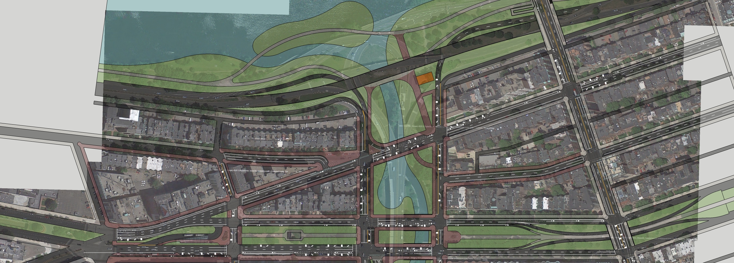
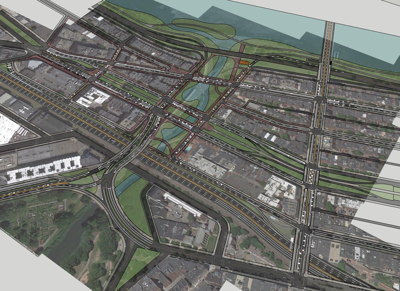
More critically for the Bowker planning there is the opportunity to more directly connect the Rte 3 Eliot Bridge traffic to the Pike eastbound instead of a messy merging with Soldiers Field Road (SFR), intersections with N Harvard, Western and Cambridge only to demerge 2 miles later. Providing this connection could accommodate one of the two key demand generators for the Bowker and SDr.

Instead of following the river where there is no inherent demand destinations, SDr might be moved onto a new alignment from the Eliot Bridge intersection on a new southeast crossing for a straight alignment directly to a Pike interchange. Portions of this road might run below grade with limited interchange at N. Harvard and Cambridge. Thus virtually the entire length of SDr from Everett St to the BU Bridge could be eliminated, or at the very least massively calmed and made permeable. This proposal would be a fantastic opportunity for growth at Harvard and Allston and BU to be connected to the Charles without crossing SDr. A descriptive example of this plan can be found here. I would propose something more radical, straighter, with a new crossing, but this provides a good conceptual starting point. It was also discussed on this fora before here (F-line's first post?)

5. Public Transportation
Most critical is the role for public transportation in removing vehicle demand given the extensive development and densification described above. Many of the needs can be addressed existing well-defined mass transit plans. Much of the vehicle demand from SDr comes from places that currently have, or are planned to have transit access.

I believe one of the critical missing components is good connections to the heart of the LMA and the need for more direct connections from the northwest of the Charles without going downtown or making multiple transfers. The Urban Ring proposal would directly address this demand (obviously there are many variations). Allowing for transfers between the Red line in Cambridge, CR and busses to cross the river and come through Kenmore, LMA, Dudley. There is also scope to take demand from Chelsea, Charlestown and Revere.

A second major program would involve improved capacity, reliability and headways. A program which would benefit all transit users. Similarly an improved bus network could add critical support with better coverage and connections and improved reliability.

Thirdly mass transit service of some kind to Waltham and Watertown, such as DMUs, or a Red line extension to Arlington and Lexington. There are many different ideas most of which have been aired in these fora.

Finally, some of the demand could be captured by CR providing further impetus for the North-South Link project to improve connection time and reduce transfers.

6. Future of Storrow Drive
In short, given the demand drivers for Bowker and its large share of traffic on the SDr it ought to be possible to reconsider the role of SDr. If substitution of the Pike / Central Artery and mass transit reduced the demand for SDr by half 25k per day it ought to be feasible to move to a 4 lane grounded signalized boulevard. This would allow far better access to the Charles and greater access for pedestrians, bikes and recreation.


That's all for now. CTSH may be sorry he asked. I have a few other posts about demand on the Bowker that will follow. My hope is that this inspires further thinking on the subject. I know there has been considerable attention paid to this topic in previous postings at other threads.

However, it is still possible that the final conclusion is that Bowker is not possible or desirable. The three main hurdles are (1) functional interchange with the Pike, funding capacity for transit improvements, ability of Pike / CA to take further demand.


* I am aware that SDr stops at the BU Bridge and becomes Soldiers Field Road, however for simplicity and naming conventions I will refer to this road west until the Eliot Bridge as SDr. From Eliot Bridge to North Beacon St, I will continue to call Soldiers Field Road for reasons that will become clear later.
 
For the EB Pike, an exit/entrance between St Marys and the BU Bridge makes sense, and really is the only place it would fit. The whole thing needs to be blown up to do it though.

For WB access, Newbury St is pretty much the only place to do it. A conventional diamond interchange won't work, there is just WAY too much traffic that will be trying to get on and off, and gridlock is sure to ensue, especially if it's in hand with tearing down the Bowker. Being able to get on the Pike at Mass Ave is also a huge benefit.

SO, I realized that Newbury St could be converted into a collector/distributor road, which allows for multiple points of egress (distributing the load), long accel/decel lanes, and retention of the Mass Ave entrance. After noticing the Pike goes down a lane through Copley, I decided it wouldn't be too detrimental to do the same here, which allows the retention of parking on the north side of Newbury; the design could be modified to retain four lanes if necessary.


12126759044_e92bfa6772_o.jpg


From East to West:
-Mass Ave: traffic enters off the Pike, Mass Ave and Newbury St.
-Charlesgate East: one way NB for traffic going into the Back Bay or getting on Storrow.
Charlesgate West: one way SB for traffic coming off Storrow, Beacon Street and WB Comm Ave.
-Kenmore Street: for traffic coming from and going to the west of Kenmore Square
-Boylston Street: traffic exits onto Boylston for Longwood, Fenway and returns onto the Pike.
-I also added a cycle track in Kenmore Square to make room for a right turn lane onto Kenmore street, and stop cabs from double parking in the bike lane.


12126637843_da9ec043ee_o.jpg


With Charlesgate East modified to deal with the traffic from the Pike.
As for the arguements that no overpass would never work because of too much traffic, I call bullshit. If the signals are networked together so the whole Charlesgate functions as one gigantic signal, it could funnel traffic just fine. Especially with this design, which has redundancies built in to distribute the load. EB Pike access should also lighten how many cars are fighting their way through here.

Thoughts? Criticism (please!)

12126944376_bb116b69aa_o.jpg
 
Last edited:
Here's a couple of Turnpike ramp proposals, quite feasible and effective in my opinion:

This one, Davem came up with, and I rendered it here:

12128251525_9baabdf213_c.jpg


This second one, I designed:

12128915286_ded96ae4dd_b.jpg
 
You can't tunnel under the Muddy. Or rather, if you did want to tunnel under the Muddy...you must go more than twice as deep. That kills all the available runup space dead. No further options. And this is the fatal blocker where the ramp proposal dies.

Green doesn't go under the Muddy

F-Line, I love reading your analysis of things, and attention to detail and grades etc, but on this point I think you are mistaken. The Green does go under the Muddy. How else does it go from Kenmore to Auditorium station? And if you are on that train leaving Kenmore I notice no steep decline way below the Muddy, the tracks are pretty flat. Perhaps I am misunderstanding what you are saying?
 
TO ant, daveM, charlieMTA

To come to this site today and see 3 of you guys proposing turning the current Mass Ave/Newbury onRamp into a pike offRamp puts a smile on my face! The thing is it is not even one of the options that is being considered by the mass DOT in their Pike Ramp study which is close to wrapping up. The closest the mass Dot comes to this is a new offRamp in the Kenmore Street/Newbury Street area, an area where I (and today daveM, thanks!) have suggested the existing onRamp be relocated to. The only suggestion I am aware of that the state has for the configuration that we are talking about is in an email I sent to the Pike Ramp study lead, Paul Nelson, an email that I have some doubt will be taken too seriously. I would suggest if anyone wants to turn their vision/our vision into reality, that you email Mr. Nelson with some of your well done diagrams (ant, daveM, and charlieMTA). Because I think turning the existing onRamp into an offRamp and relocating the onRamp (as daveM does) is a better option for improving local access to/from the Pike. The Pike's 'alternative 3' plan, sends Pike traffic one way only: onto Newbury near Kenmore Street, and then down to Brookline Ave, just south of Kenmore Square. That is just asking for traffic disaster. Paul Nelson's email is: Paul.Nelson@dot.state.ma.us and they claim to be seeking public comments, so please do comment (and better yet attach your graphics!)
 
Last edited:
daveM: First of all your work is beautiful! Congrats. I also like how you found precedence at Copley to give up a lane westbound in the Bowker area. As cited above, I agree obviously 100% on your pike on and off ramp locations.

I will put in another pitch for adding further utility to the Pike offRamp by a new ramp from Newbury at Bowker, rising up in a circular manner to meet the Bowker/Pike overpass in a southbound direction, providing better access from the new Pike offRamp up to the Fens, Longwood, NU, MFA, Roxbury etc than would be the case using the one lane westbound Brookline Ave (which still could be used in addition to the new ramp I am suggesting here). Of course, this would mean shifting the action of your surface Bowker replacement from Charlesgate West toward more onto the Charlesgate East direction to give the space for this new merge onto the Pike overpass here. I suspect your objection is a new ugly ramp in the Charlesgate, and if so I understand and agree somewhat. On the other hand there is and will be an already ugly ramp here to/from over the Pike so connecting to it doesn't uglify the area much more that the current ramps do, in my opinion, and this ramp drives some amount of traffic away from the Charlesgates, helping with volumes there on your new surface Bowker. You would now have one new Pike offramp providing direct straight forward access in 3 directions: the Back Bay, the Fens, and Kenmore Square. Perhaps the tightness of the area prohibits such a Fens bound ramp in the first place (and I can hear F-line in my ear saying just that) , though this would obviously be slow-speed, not high-speed traffic that would be navigating up this circular ramp from Newbury over the Pike. This ramp is depicted below (you can ignore the rest of the map!)

4810508_orig.jpg


Another suggestion: look at the south end of your graphic and the roadways crossing each other where the Bowker meets Boylston/Park Drive. Of course there are traffic lights there, fairly long waits to let traffic coming from the other direction cross your path etc (the intersection shows as grade D on some of the DOTs intersection slides). Now give this a thought: imagine turning the north of the Fens into a one-way counter-clockwise loop. What happens? That Bowker/Boylston/Park Drive intersection is simplified, perhaps the traffic lights can be removed, at least one lane can be removed from Park Drive heading south toward the lower half of Boylston (and from The Fenway heading north). Traffic coming from Longwood would have to turn right, flow down Agassiz and then up The Fenway to get to the Bowker. A bit longer yes, but often quicker as you spend less time waiting at traffic lights. In fact red light wait time can be eliminated or significantly reduced all around this loop (at the Bowker, at Boylston/Park Drive, Fenway/Westland, and Fenway/Boylston). Further, you could reconnect Boylston at the Bowker at the top of the loop and not force cars to exit at the Bowker as they must now (again, reducing volumes for the Charlesgates, further justifying a surface Bowker). Ok, you would probably have to add a lane to Agassiz, and I can hear people screaming about that, but you are removing more lanes from the 2-way parts of the loop, meaning more (not less), Fens parkland overall. Access to the Fens by peds/bikes is improved also as you only cross against one-way, not two-way traffic. I see more upside than downside to this rearrangement. This flow is depicted below (you can ignore the rest of the map!)

I will close by quoting you, "Thoughts? Criticism (please!)"

8502605_orig.jpg
 
Last edited:
ant: I am "all aboard" with your idea for dipping the train tracks in the Bowker area to allow an eastbound Pike onramp. This configuration would also work I would think with the one way Fens proposal in the map above. If you can sink a miles long green line tunnel 100 years ago on the north side of the Pike, I have a hard time believing we cannot today sink the commuter rail tracks for a short distance on the south side of the Pike! Yes, I do understand your (and F-lines) concerns about decline and amount of space to work with and yes, it could indeed be a show-stopper but do we in fact know that the descent cannot begin, not at Mass Ave, but further east than that, giving more length for the tracks to descend downward toward the Bowker?
 
Last edited:
This second one, I designed:

12128915286_ded96ae4dd_b.jpg

You and the DOT think alike, at least a little bit anyway! Your off ramp is a combination of 2 ideas under consideration by the DOT "Back Bay Alternative 1: New Westbound Off Ramp to Berkeley Street ", and Back Bay Alternative 2: New Westbound Off Ramp to Trinity Place/Stuart Street (one starts where yours starts, and the other ends where your ends, but starts further east)

http://www.massdot.state.ma.us/Portals/27/Docs/PublicMeeting_Part2_120413.pdf
 
What's the point of removing the Bowker if you're going to fill up that space with roads? The whole point is to get this back:
4a07523r.jpg
bowker-historic1.jpg

You either have to design for aesthetics, or for maximum traffic throughput. You have to pick one or the other, not both.

Also, eliminating Beacon would almost certainly overwhelm WB Comm Ave beyond what it could handle (notice how EB Comm is double the width of WB?; that's because Beacon picks up all that slack). Besides Storrow, it is THE ROAD to get from downtown to Kenmore and beyond, as well as all the WB traffic coming off the Mass Ave bridge. Eliminating Beacon would also get rid of Bay State Road as a bypass for those going to Comm Ave west of Kenmore Square, plowing all that traffic through the already choked intersection. I know the way you have the ramps configured does allow you to continue through, but who would put themselves through that much traffic?


When you're proposing these designs, make sure you consider clearances. A ramp, even if just a single lane, has to be 20' (MAYBE you could get away with 18') wide so that an emergency vehicle can get by when there is snow piled up. Most of the ramps they built for the Big Dig are 22'. You need room for vehicles to queue up at lights, preferably 100'-200'. You need weaving room, so someone entering in the far right lane can cross over to the far left without causing an accident. You need the ramp up to the Pike overpass to have as small a slope as possible, otherwise you have a blind hill. If you're tunneling, you need to get under the green line enough to underpin it, I'd guess least 30' below grade. You need adequate decel and accel lanes to get on/off Storrow and the Pike. And most importantly is curvature. Your ramps look dangerous on a bright, sunny day (due to both the tight curves and the amount of weaving they would require). Now imagine traversing that with black ice: accident city.


Simplify, simplify, simplify. If you have to think too hard or come up with something elaborate, it's almost certainly not going to work.
 
Last edited:
You and the DOT think alike, at least a little bit anyway! Your off ramp is a combination of 2 ideas under consideration by the DOT "Back Bay Alternative 1: New Westbound Off Ramp to Berkeley Street ", and Back Bay Alternative 2: New Westbound Off Ramp to Trinity Place/Stuart Street (one starts where yours starts, and the other ends where your ends, but starts further east)

http://www.massdot.state.ma.us/Portals/27/Docs/PublicMeeting_Part2_120413.pdf

In my view the majority of these access points need to be farther west similar to Davem's proposals and the 'BU'-location for eastbound ones.

Eastbound
These are very close to the I93 interchange and are likely to get caught up in its traffic during the peak or to 'cause' traffic because of the need for merging and dropping a lane. (At BU, there is better existing unused capacity).

The off-ramp is redundant there is already a Pru exit two blocks west.

There is an on-ramp effectively 1 block east of here - Hearld to Albany St. Granted it is typically jammed, but so would the proposed 3-lane westbound Pike for similar hours.

This configuration would be best for trips between Back Bay and the Seaport & Logan. But arguably it would be no better during peak traffic, and at off-peak it would only be marginally better than local routes.

For traffic going to 93N and Tobin, it's not going to save much time over Storrow depending on traffic.

Westbound
On Westbound, it would very good for travel from Logan / Seaport to the Back Bay and possibly Roxbury. But in comparison with the Arlington exit from Storrow, even with no traffic, it's only favourable for the southern parts of South End and Mass Ave. And it would be no benefit vs Bowker. And when you add in the time difference given traffic between Central Artery / Pike vs Leverett to Storrow there is not likely to be any benefit at all.

In summary, the east-on and west-off are somewhat useful for Back Bay / Seaport & Logan usage vs local streets but much less useful in other contexts. Further, the eastbound exits are duplicative and disruptive. Most importantly I do not see how these ramps would take much or any demand from Storrow and the Bowker.
 
ant: I am "all aboard" with your idea for dipping the train tracks in the Bowker area to allow an eastbound Pike onramp. This configuration would also work I would think with the one way Fens proposal in the map above. If you can sink a miles long green line tunnel 100 years ago on the north side of the Pike, I have a hard time believing we cannot today sink the commuter rail tracks for a short distance on the south side of the Pike! Yes, I do understand your (and F-lines) concerns about decline and amount of space to work with and yes, it could indeed be a show-stopper but do we in fact know that the descent cannot begin, not at Mass Ave, but further east than that, giving more length for the tracks to descend downward toward the Bowker?

A mainline railroad should have no more than a 1% grade. That's 1 foot of rise for 100 feet of run. I think you need 14' of vertical clearance since past the Grand Junction its not a freight route. That's 14' underneath the viaduct you would need to build for the Muddy River (which would be what, 10' deep?) So, you would have to start the decline somewhere around the BU bridge, blow up the newly constructed Yawkey Station because it's too high now, and somehow get digging machinery underneath the Pru complex to dig there. Not to mention what are you going to do for the five or so ears it would take to do this? Route ALL Amtrak and MBTA trains over the Grand Junction to North Station? To quote F-Line, it's a non-starter.
 
ant: I am "all aboard" with your idea for dipping the train tracks in the Bowker area to allow an eastbound Pike onramp. This configuration would also work I would think with the one way Fens proposal in the map above. If you can sink a miles long green line tunnel 100 years ago on the north side of the Pike, I have a hard time believing we cannot today sink the commuter rail tracks for a short distance on the south side of the Pike! Yes, I do understand your (and F-lines) concerns about decline and amount of space to work with and yes, it could indeed be a show-stopper but do we in fact know that the descent cannot begin, not at Mass Ave, but further east than that, giving more length for the tracks to descend downward toward the Bowker?

I don't object to the idea. It would be great if there was three grade separations in existence from day one (1) transit (2) flood control (3) express roads (4) local roads and transit. But even assuming all the geometry works, the costs are going to be immense.

You are basically seeking to build a cut and cover tunnel directly next to an enormous number of abutters plus a narrow highly active interstate for a very long length. Access will be a nightmare, both sides will require sheet piling or underpinning. And then half way through you are going to have to go very deep with challenging water conditions and environmental issues just to dip a very small river.

I don't say the engineering is impossible, or even particularly difficult. But cost wise it's just not anywhere close to reality. We all like to think about, propose and fantasize about 'challenging' projects and I don't mean to discourage that. But I'm afraid, the rationale of the this project doesn't get anywhere near justifying it's costs.
 
What's the point of removing the Bowker if you're going to fill up that space with roads? The whole point is to get this back:
4a07523r.jpg
bowker-historic1.jpg

You either have to design for aesthetics, or for maximum traffic throughput. You have to pick one or the other, not both.

Also, eliminating Beacon would almost certainly overwhelm WB Comm Ave beyond what it could handle (notice how EB Comm is double the width of WB?; that's because Beacon picks up all that slack). Besides Storrow, it is THE ROAD to get from downtown to Kenmore and beyond, as well as all the WB traffic coming off the Mass Ave bridge. Eliminating Beacon would also get rid of Bay State Road as a bypass for those going to Comm Ave west of Kenmore Square, plowing all that traffic through the already choked intersection. I know the way you have the ramps configured does allow you to continue through, but who would put themselves through that much traffic?


When you're proposing these designs, make sure you consider clearances. A ramp, even if just a single lane, has to be 20' (MAYBE you could get away with 18') wide so that an emergency vehicle can get by when there is snow piled up. Most of the ramps they built for the Big Dig are 22'. You need room for vehicles to queue up at lights, preferably 100'-200'. You need weaving room, so someone entering in the far right lane can cross over to the far left without causing an accident. You need the ramp up to the Pike overpass to have as small a slope as possible, otherwise you have a blind hill. If you're tunneling, you need to get under the green line enough to underpin it, I'd guess least 30' below grade. You need adequate decel and accel lanes to get on/off Storrow and the Pike. And most importantly is curvature. Your ramps look dangerous on a bright, sunny day (due to both the tight curves and the amount of weaving they would require). Now imagine traversing that with black ice: accident city.


Simplify, simplify, simplify. If you have to think too hard or come up with something elaborate, it's almost certainly not going to work.

Well, nice photos but unless your plan calls for eliminating an overpass to the Pike, the ramps to/from that overpass are still there in the Charlesgate ... nothing like those photos, so connecting to those existing ramps that probably will never go away doesn't pile on too much, I don't think, as it is all in the same corner of the Charlesgate. And yes, I agree, and have thought of possible/probable degree of curvature being too much, and possibly width also, but I threw this out there for better engineering minds better than my own to say yes or no to. I certainly am not qualified to make a call like that either way! Not that I want to waste your time, or anyones time looking at things like this if they are clearly impossible to implement. But if possible, it obviously has a significant benefit to the utility of a Pike off-ramp in the proposed location.

The Beacon Street reversal idea is not mine, but someone elses idea, and I do see all your points about traffic flow. Still, and no offense here, I find it a bit contradictory to hear you say on the one hand 'yes, take the 50,000 cars the Bowker handles each day and put them on the Charlesgates ... properly synched lights can handle it" and on the other hand say, "Oh no, asking Comm Ave traffic to handle Beacon Street traffic ... that will never work"! And I know about Bowker being "the road" to get westbound, beside Storrow, though I have found so much double parking that it sometimes feel like there is only one true travel lane on it (yes, i am exaggerating, a bit).

As an alt to Beacon reversal I do have the up and over Storrow ramp in my 1st diagram, which also has the benefit of eliminating a serious traffic choke point where Storrow exits onto Charlesgate West at Bay State Rd/Beacon. Is this the area that you think would have 'so much traffic' that no one would use it? I am not sure that has to be the case, esp with no Beacon intersection anymore that traffic now backs up at.

As a practical matter getting state agreement to flowing Bowker traffic thru current Charlesgate intersections is a pipe dream unless Pike access can be improved to such a degree that Storrow is needed that much less (and thus the Charlesgate that much less). Hence, my striving to up as much as possible the utility of Pike on/off ramps, which is the rational for suggesting that ramp to the Fens. But even with improved Pike access, my guess is it will still be a tough road to getting an OK for funneling Bowker traffic thru Cgate intersections. Just my feeling, from the tone I have been hearing at the public hearings (hence my attempts to getting surface Bowker traffic going thru the Charlesgate without dealing with intersections).

I appreciate the specs/guidelines (lane width, etc). As for tunneling, I know suggesting that is almost a lost cause, as much as I would love the Bowker and its traffic down and out of sight! But that is one idea I am not putting out there for that reason.

Oh, and hear is the rational of a Beacon reversal that I have been given ...

> 1. BEACON STREET CHANGE WEST OF MASS AVE & THRU THE CHARLESGATE
>
> Engineers very familiar with the Bowker Alternatives suggested to us a
> possible modification that might make Alternative #1 (removal of the Bowker
> & widening Charlesgate E. & W. respectively to accommodate traffic from the
> lost overpass) somewhat more palatable to the DOT group. Alternative #1
> could be tweaked to allow traffic to move much more smoothly on Cgate E &
> W. by closing Beacon St. between Cgate E. & W. Traffic on Beacon St.
> between Cgate E & Mass. Ave. would be reversed for that one block to a west
> to east flow (much as the City did with the same parallel block of Marlboro
> St. a few years back) so that Beacon St. traffic would not be forced to
> flow onto Cgate E. This idea holds substantial merit for several reasons:
>
> 1) It would eliminate the need for traffic lights on Beacon St. where it
> intersects Cgate W & E. thus leaving only the lights at Commonwealth, thus
> helping expedite traffic flow (i.e. not two lights to pass through but only
> one) down those two streets
>
> 2) This plan would actually be a vast improvement to what currently exists
> since you are now dealing with backup at the Storrow exits onto Charlesgate
> W. Now all the traffic off of Storrow trying to go west on Beacon or Bay
> State (from a purely visual observation, about 50% of the total traffic)
> would no longer have to contend with a traffic light at Beacon; vehicles
> would simply move from Storrow onto Beacon/Kenmore Sq. without delays or
> backup, a vast improvement to what is happening now. The same applies to
> Charlesgate E traffic: the removal of the Beacon lights would permit
> traffic to flow smoothly onto Storrow E. & W.
>
> 3) This reversal of traffic on Beacon St. between Cgate E & W. would be a
> major plus for residents on Beacon St. between Charles St. (Beacon Hill)
> and Mass. Ave. since it might in all likelihood reduce the heavy truck &
> bus traffic that now uses Beacon as a “mini-expressway” to Kenmore & west
> (since they are banned from Storrow due to height/weight requirements and
> from Comm. Ave for Back Bay traffic control reasons). These westbound
> vehicles, if they chose to still use Beacon, would now have to turn one way
> or the other on Mass. Ave. We would think many of these drivers, many
> trying to avoid turnpike fees, would eventually seek other, more time
> effective, routes.
>
> 4) This would allow the historic “Beacon Entrance” bridge to be narrowed
> and turned into a pedestrian/bicycle path E/W much like has been done in
> the Fens. This obviously would further reclaim valuable park area; it would
> give light to a large section of the stagnating Muddy River just before it
> enters the Charles as well as make the restored park more attractive &
> user-friendly.
>
> 5) Pedestrian walk signals on Beacon St. would still be maintained but at
> a wider interval.
 
I've got different stuff to do, but both those pictures are looking NE from the corner of Comm Ave towards Beacon. The pike overpass has nothing to do with this area.
 
I don't object to the idea. It would be great if there was three grade separations in existence from day one (1) transit (2) flood control (3) express roads (4) local roads and transit. But even assuming all the geometry works, the costs are going to be immense.

You are basically seeking to build a cut and cover tunnel directly next to an enormous number of abutters plus a narrow highly active interstate for a very long length. Access will be a nightmare, both sides will require sheet piling or underpinning. And then half way through you are going to have to go very deep with challenging water conditions and environmental issues just to dip a very small river.

I don't say the engineering is impossible, or even particularly difficult. But cost wise it's just not anywhere close to reality. We all like to think about, propose and fantasize about 'challenging' projects and I don't mean to discourage that. But I'm afraid, the rationale of the this project doesn't get anywhere near justifying it's costs.

I agree also. In my mind it does go in the fantasy category, rather that something that would realistically be done, as much as ant gave me brief hope otherwise, but I have had this fantasy for a few years now and I've never put it to paper, but when ant did suggest it I couldn't help but add my 'me too!'. Though I understand the issues everyone has talked about, and that is basically why I have only had it in the fantasy section of my brain. And also, the daveM thing too about what about the trains running there now and what do u do about them while u build this. My little fantasy world had them closing Ipswich for awhile and the trains running down there, if the angles could be met, but again this aspect just helped me keep this one in the fantasy category where i guess it has to stay. Right next to my fantasy project of dropping the Bowker into a tunnel under the Charlesgate.
 
Last edited:
both those pictures are looking NE from the corner of Comm Ave towards Beacon. The pike overpass has nothing to do with this area.

I know that, and neither does the ramp I am suggesting to the Fens go into that area in your photos, which I assumed you knew. So now I guess i don't understand your point. The aesthetics in the ramp area are going to be lousy, with or without a ramp up to the Fens is my point. I guess slightly less lousy without my ramp to the Fens, I will concede that, but in any case nowhere near like those photos towards the other side of the Charlesgate. That will never happen on the south end of the Charlesgate.
 
What if you completely forget about connecting the Fens roads to Storrow, and just focus on connecting the Fens roads to the Pike?

Use a European X style crossover bridge (Single Point Urban Interchange) to connect both directions. Then only surface connections in the Back Bay to Storrow connections. Make the Pike do the downtown and outbound connection work from the Fens?
 
Last edited:

Back
Top