Cape Cod Rail, Bridges and Highways

1712493811644.jpeg

I just came across this picture from, looks like, 1960s. A Traffic jam trying to get over the canal. It looks basically identical to the situation today.

We know how to make this better for everyone, and it involves creating reasonable alternatives to driving. It's investing in getting more trains back and forth across the canal, or designing bus-only lanes through this bottleneck. It's making the cape less car dependent once you get there: better public transit; more walkable cities; safe routes to get around on foot, or bike, or scooter, or golf cart, or literally anything smaller and safer than a car. If we make those options comfortable, fast, and easy, people will take them, which even makes things better for car drivers in thinned out traffic.

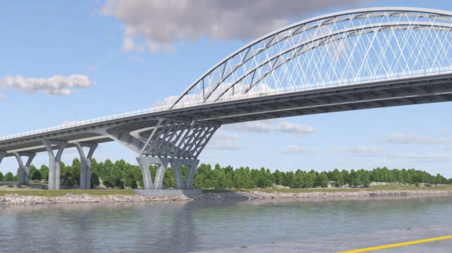
When big ticket items come up, like replacing these car bridges, it's worth considering whether we're building any of those alternatives, too. It's worth getting pissed off that the answer is basically, no, not really. The cost of replacing these bridges could easily be more money than all the public transit funding we've spent on the cape since that photo was taken. We should really change that. Otherwise we're just rebuilding that same traffic jam for the next three generations to sit through.
 
I rather have to agree. Short of filling the canal in, the bridges are pretty important and a direct problem caused by the state when they created the canal.

The state did not "create" the canal. It was built by private enterprise and opened in 1914. The canal was purchased in 1928 by the federal government and greatly widened in the 1930s. With the 1928 purchase, the federal government assumed the rights and obligations to operate and maintain the canal. That included the road and rail crossings. See the "Private construction" and "Public takeover and expansion" sections of the Wikipedia entry for the Cape Cod Canal for a reasonably accurate history.

In recent years, the state has entered a couple of Faustian Bargains with the feds to maintain the canal crossings. The first was the recent rehabilitation of the railroad bridge. The federal government funded it, but as part of an apparent agreement, the state relinquished some railroad crossing rights. We see the fallout from that agreement today: Despite repeated requests to run an additional CapeFlyer roundtrip summer Saturdays for the benefit of Cape residents, the U.S. Army Corps of Engineers has refused the bridge crossings, citing the impact to maritime traffic.

The Army Corps' impact assertion is laughable. Consider the history of the past 40 years. In the 1980s, before rehabilitation, the railroad bridge saw much higher traffic with both the Cape Cod & Hyannis and Amtrak Cape Codder services. Since then, the bridge has been rehabilitated, and by the Army Corps' own admission, as published in their annual "Waterbourne Commerce of the United States," tonnage through the canal has dropped by nearly 60% since the 1980s. In 1985, 14,539 thousand tons transited the canal, while in 2019 (the last year before the pandemic), that number had dropped to 6,715. The later publicly available data shows a much sharper drop during the pandemic. Clearly commercial maritime traffic is not a reason there can't be increased rail use of the bridge, weekends or otherwise.

The state's second Faustian Bargain is taking on ownership of the new highway bridges as an expedient for their construction. In essence, the state has agreed to take on some of the construction and all of the maintenance costs of the new bridges -- items for which the federal government should be solely responsible as long as the canal is in operation.

Should the canal remain in operation is a reasonable question to ask. Given the documented sharp drop in commercial tonnage, does it make sense to spend billions on new highway bridges, let alone the operational costs of the canal? The answer might still be yes, but it is not a given fact.
 
When big ticket items come up, like replacing these car bridges, it's worth considering whether we're building any of those alternatives, too. It's worth getting pissed off that the answer is basically, no, not really. The cost of replacing these bridges could easily be more money than all the public transit funding we've spent on the cape since that photo was taken.
Agree with your overall point, but from the material Ive seen, it does appear that a lot of effort is being spent on providing high quality paths over both bridges. Good bike infra isn’t an alternative for the long distance traffic using the bridges obviously, but it also ain’t nothing. Sure will beat the 4’ wide ‘safety walk’ (lol) that is the only other, all year option over the canal than in a car.
 
You all know more than I do but wanted to mention it here in case you hadn't heard so you can do more research.

Provincetown voters chose to take away control of the Old Colony railway from the select board to the Open Land Trust, effectively canceling any hopes of expanding the Cape Cod Rail Trail two miles into the town's center.* (The Old Colony ran a train from Boston / points west to Provincetown from 1873 until ~1938 (last one in 1940) and pulled the rails up when the Commonwealth built Route 6 next to it.)

The Trail will remain to be used for "passive recreation" and it's assumed the Trust will keep the pathway from being paved over. That was the main reason for the results vote - basically, to keep motorized bicycles and scooters from being used on the Trail. It's currently a dirt path with several sandy parts, so it gets very limited use currently by any cyclists. It's mostly just me using it as a running route and a bunch of old people letting their dogs shit everywhere.

*The Cape Cod Rail Trail currently ends somewhere in Wellfleet. Then it merges directly onto Route 6, a four lane highway, for the next several miles until it's near the center of Provincetown. There are proposals to pull more of the Trail off the highway but stuck in the opposition phase. The logical expansion of the Trail would have taken it off Route 6 at the Truro / Provincetown border and then, following the Old Colony path, to Harry Kemp Way and to the center of town. An excellent idea as it is much safer than Route 6.

Oh, there are also proposals now to build a segregated bike lane on Route 6, removing two lanes of car traffic and replacing them with the bike lane and a pedestrian lane. And parking for 60-100 automobiles. No, I wish I were kidding.
 
Last edited:
Is there any realistic chance of the existing stations in Sandwich and West Barnstable becoming stops on the CapeFlyer within the next decade or so? What are the obstacles to serving these stations?
 
Is there any realistic chance of the existing stations in Sandwich and West Barnstable becoming stops on the CapeFlyer within the next decade or so? What are the obstacles to serving these stations?
Not much. The one-car temp mini-high infilled at Bourne was fairly successful at attracting ridership, so there's nothing in the service plan that says the pre-existing ADA mini-highs at Sandwich and West Barnstable can't be added. It just hasn't been a priority for the Cape Chamber of Commerce because they've been focused for the last 10 years on muscling funding for track improvements and (more recently) trying and failing to get more schedule slots.

You'd probably need to get some CCRTA bus integration to make it work. The Barnstable Villager route avoids West Barnstable, so barring a radical redraw that station may not have any connecting transit. But the Sandwich Line gets within about 5 blocks of Sandwich Station (and I think in past years was drawn to even serve the station itself), so it wouldn't take much of a tweak to get that one on the board.
 
Yes, there's little chance that Sandwich or West Barnstable will become CapeFLYER stops. CCRTA administrator Tom Cahir has made it clear he opposes additional stops for the train, over concern on extending the run time. He was not in favor of adding Wareham Village 10 years ago, but he was overruled by the state.

Ironically, while he claims concern over the run time, he is not in favor of increasing the train's speed on the Cape. The current speed limit is 30 mph; in the 1950s and early '60s the New Haven ran its passenger trains at 50. Meanwhile, the speed limit on parallel route 6A is 45 in many sections -- a road that sees far more activity with bicyclists and pedestrians.

It's understandable that he would be opposed to adding more stops because of concerns about travel time, but it's very odd that he would be against increasing train speeds on the Cape. Aside from cost (which is obviously an issue) what other downsides to increasing train speeds does he anticipate?
 
It's understandable that he would be opposed to adding more stops because of concerns about travel time, but it's very odd that he would be against increasing train speeds on the Cape. Aside from cost (which is obviously an issue) what other downsides to increasing train speeds does he anticipate?

Noise perhaps?
 
It's understandable that he would be opposed to adding more stops because of concerns about travel time, but it's very odd that he would be against increasing train speeds on the Cape. Aside from cost (which is obviously an issue) what other downsides to increasing train speeds does he anticipate?
At least by poking around on Google Street View:

The ROW is pretty much entirely unfenced and has a large section of it's run where there's lots of unauthorized pedestrian crossings at many different points, many of which have bad sight lines for both pedestrian + train operator. Pretty much everything where it's running along the canal west of the power station - you've got a path on the canal side and if there's anything on the land side of the rails, there's clear evidence of frequent pedestrian crossings to/from the path.

Even if people weren't intentionally crossing at all....I'd be leery that you're going to be hitting some children or pets some day who are just running around near the trail and strayed a little too close if the train's moving faster, it's remarkably bad.

-------

While the public road crossings do mostly have at least some sort of active warning, they also have a bunch with terrible geometry - long, shallow-angle crossings. And there's still at least 4 totally unprotected private/semi-private crossings by my count, at least one of which DOT appears to have firmly lost a court case to close last year. (Railroad Ave, Barnstable).

---------

The railroad might not be legally in the wrong if something happens at any of these points - but given that it's a public entity that answers to public opinion + cares about the optics (and, ideally, lives), I can see reasons to question raising the speed without further safety work.
 
Meanwhile, the bike path group is still looking to kill off the rest of the Falmouth Branch was at it again. Retired Senator Susan Moran had snuck in a amendment to convert the line to a bike path. Having gotten some pushback, she withdrew this and submitted another one authorizing studying a way to build a spur from the Cape Main to Otis - therefore allowing the abandonment the present track. Here is her response to a friend's e-mail opposing her original amendment:

Thank you for contacting me regarding the preservation and continued operation of the MassDOT Falmouth Secondary Rail Line in Bourne and Falmouth. I have met with many supporters and opponents of the plan to convert the Falmouth Secondary Line into a bike path that would create new tourism infrastructure and link the 6.5-mile gap between the Cape Cod Canal Bikeway and the Shining Sea Bikeway. This would ultimately create 24 miles of uninterrupted pathway for pedestrians and cyclists to enjoy on the Upper Cape.

As you are likely aware, the Falmouth Secondary is limited in its current functionality, and is not currently used or rated for commuter transportation. After several meetings with local and state engineers, it has become clear that any future use of this line would require expansive infrastructure improvements to allow for regular use, including a new train bridge over the Cape Cod Canal.

My colleagues and I, as well as representatives from the Cape Cod Regional Transit Authority and Department of Transportation, have carefully considered the cost restriction, legal limitations, economic significance, and environmental impact of each option while working to establish a plan that is beneficial for all Cape Cod residents and visitors.

As your State Senator, it is my responsibility to prioritize infrastructure investments that contribute to economic growth, job creation, sustainability, and reducing inequality in my district. I filed amendment #331 to S.2856 - An Act relative to strengthening Massachusetts’ economic leadership, which will expend $8,750,000 for the construction of a rail spur connecting Joint Base Cape Cod to the Cape Cod Main Rail Line, opening up new possibilities for this rail line.

I remain committed to working towards a thoughtful, well-planned resolution that will allow for the repurposing of the Falmouth Secondary for economic and lifestyle prosperity, without compromising public safety or future rail infrastructure projects.
Sincerely,

Susan L. Moran
State Senator
 
After several meetings with local and state engineers, it has become clear that any future use of this line would require expansive infrastructure improvements to allow for regular use, including a new train bridge over the Cape Cod Canal.
WHAAA??? In what universe does upgrading the tracks for "regular use" (hint: it is used regularly by the Dinner Train) require a new bridge over the Canal? I can't even fathom what she's getting at here.

As your State Senator, it is my responsibility to prioritize infrastructure investments that contribute to economic growth, job creation, sustainability, and reducing inequality in my district. I filed amendment #331 to S.2856 - An Act relative to strengthening Massachusetts’ economic leadership, which will expend $8,750,000 for the construction of a rail spur connecting Joint Base Cape Cod to the Cape Cod Main Rail Line, opening up new possibilities for this rail line.
The proposed replacement spur is 2 miles alongside the Route 28 shoulder dead-ending at the Bourne landfill. 5 miles shy of Joint Base and 8 miles shy of the trash transloading freight customer currently on the Falmouth Secondary. It's beyond useless for any potential user. And we're proposing to spend $8.75M on that??? It's a good thing Sen. Moran is already retiring. She'd get booted out of office quick for lighting that much money on fire to no end.


Meanwhile, the Falmouth Secondary has $14.4M in improvements spread across a dozen line items in the MassDOT 2025-2029 CIP, so the rest of the state continues investing in the active rail corridor. . .
1720729334400.png

1720729369000.png
 
MassDOT today won an additional $993 Million for the Sagamore bridge from USDOT's Bridge Investment Program. This means that Sagamore has received a total of $1.71B in Federal Funding to date. With the addition of state matching funds, this should be enough for Sagamore to be built.

 
MassDOT today won an additional $993 Million for the Sagamore bridge from USDOT's Bridge Investment Program. This means that Sagamore has received a total of $1.71B in Federal Funding to date. With the addition of state matching funds, this should be enough for Sagamore to be built.

Cool! It will be a big win for active transportation (bikes and peds) across the Canal.
 

Back
Top