Crazy Transit Pitches

No. There's no where to branch off of Fitchburg through Weston and Lincoln to get to Hanscom. It's not at all easier than trying to tango with the Minuteman ROW.

After Walden Pond branch down along Rt 2 and 2A to Hanscom. A lot of people will be pissed, but not tens of thousands like with Minuteman, just thousands.


The idea is that someday in the mid-future Hanscom will be BRAC'd and that land will open for development. Maybe nothing comes of it due to community opposition in Concord, Lincoln, Bedford and Lexington. But if it does, it should have transit because of the extra burden that would be placed on the existing corridors.

Unless the airfield is nixed (not part of the base technically) then the base is already substantially built out and you can't build up much more with height restrictions.

In terms of desirability we have several cities that were designed to be dense and are in need of redevelopment. Also, how much more are we planning to grow? Population is going to plateau or decline at some point, one way or another. I would be looking to consolidate already developed areas with redevelopment. If the airfield isn't needed someday, then plant some trees and focus on redevelopment of places elsewhere with established downtown areas and infrastructure.
 
After Walden Pond branch down along Rt 2 and 2A to Hanscom. A lot of people will be pissed, but not tens of thousands like with Minuteman, just thousands.

Piss off thousands of people and the Federal Government, which runs the National Historical Park, and every fan of historic battlefield preservation in the country... Trust me; negotiating with Lexington over Minuteman would be way easier.


Unless the airfield is nixed (not part of the base technically) then the base is already substantially built out and you can't build up much more with height restrictions.

Who said anything about substantial height?

In terms of desirability we have several cities that were designed to be dense and are in need of redevelopment. Also, how much more are we planning to grow? Population is going to plateau or decline at some point, one way or another. I would be looking to consolidate already developed areas with redevelopment. If the airfield isn't needed someday, then plant some trees and focus on redevelopment of places elsewhere with established downtown areas and infrastructure.

That may well be what happens. And if that's the case, then Red will happily never go beyond heights.
 
Piss off thousands of people and the Federal Government, which runs the National Historical Park, and every fan of historic battlefield preservation in the country... Trust me; negotiating with Lexington over Minuteman would be way easier.

Still a shorter run through a less densely populated area with many ways to mitigate the impact because there is room to do so. I think it is slightly less absurd than Minuteman. Just slightly...
 
Still a shorter run through a less densely populated area with many ways to mitigate the impact because there is room to do so. I think it is slightly less absurd than Minuteman. Just slightly...

Feel free to think that. But I wouldn't ever assume that trying to lay a new rail right of way through National Park Service land in 2050 would be less absurd than wheeling and dealing with 2050 Lexington over the Minuteman ROW.
 
Feel free to think that. But I wouldn't ever assume that trying to lay a new rail right of way through National Park Service land in 2050 would be less absurd than wheeling and dealing with 2050 Lexington over the Minuteman ROW.

The only E-W ROW running to Hanscom is the Reformatory Branch from West Concord, abandoned 1960. Branched off the Framingham & Lowell ROW several hundred feet north of WC station after the F&L crossed the Fitchburg Line on a diamond. Ran east to Bedford Depot parallel to Route 62 and Railroad Ave. Bedford & Billerica continued north with the depot's sidewalk on the parking lot side being the mainline platform, and the platform where the restored Budd car is stored being the Reformatory Branch and yard short-turn platform. The branch is an unpaved trail (pretty nice, although not as well-patronized or getting as much landscaping attention as the Bedford & Billerica trail running north).


Problems with it, though. . .
-- The branch crossed the Assabet and Sudbury Rivers five times on the last mile to get into W. Concord, which is why the trail dead-ends at Lowell Rd. northeast of Concord station.
-- That part over the river was abandoned much sooner the rest east to Bedford...sometime during the Depression.
-- The ownership's lapsed through all the wetlands, so they can't even continue the trail if they wanted to.
-- It required a backup move off the Fitchburg at West Concord onto the F&L because of the Fitchburg's own Assabet River crossing just east of the station.
-- It was built by Fitchburg RR's competitor, Boston & Lowell RR, who used the Lowell Line + Central Mass/Fitchburg Cutoff + Lex + F&L to get there so it didn't touch any of Fitchburg's track. So it wasn't even built with the intention of access to/from the Fitchburg.
-- By the time all the northside RR's came under common control...the routing was too baked-in to change.
-- Because of that it supposedly only had something like 2 trains per year in its last 25+ years of service. It was probably the lowest-use branchline in the whole state that lasted into the 20th century.
-- There's no way to tie it back in to a different place and fix the wetlands or junction because of the surrounding density; it's 2 miles of wetlands with multiple river crossings or bust.
-- The Minuteman, which actually has MBTA ownership and a real RR charter under landbanking protection, will always be the easier-to-EIS and approve routing. Despite Lexington's kvetching about the trail. That's how much wetlands get fouled trying to fashion something out of the Reformatory.
-- It takes 45 minutes on the Fitchburg Line to get to West Concord...before the back-track to Bedford. A bus out of Weston/128 that gets stuck in highway traffic will always beat it. Always...even on a disaster commute day.


You get the point. There's only one way to Hanscom. And it's not through the national parkland.


Burlington's never ever had a railroad in town. I think it's the only town inside 495 that's never had one ever. The Lex branch and Lowell Line...same as today...were the closest ROW's, and Boston & Lowell RR basically built a 'donut' of rails completely around Burlington and never thought to fill the center with anything. Maybe there were dragons in it. Or they're in the midst of a 300-year probation from the Freemasons. I don't know...they sure did something to scare the early 19th c. investors away who were building redundant lines in a frenzy.


Any which way this is hard enough and enough phases in the future--if ever--that a BRT bridge era of considerable duration is non-optional. Definitely for Burlington, probably for Hanscom.
 
Feel free to think that. But I wouldn't ever assume that trying to lay a new rail right of way through National Park Service land in 2050 would be less absurd than wheeling and dealing with 2050 Lexington over the Minuteman ROW.

I would assume you would have to deck, depress or otherwise mitigate the whole thing either way, so 3 miles of branch off the Fitchburg Line with fewer stakeholders to please versus 8 miles up the old minuteman ROW with a denser population that really really like the bike path.

Either way not going to happen in 2050 or 2100 time frames as long as we retain some semblance of a democratic form of government, but I think circumferential routes along Rt 128 either by BRT or rail are good to consider for brain storming purposes.

And also ideas to link the the exurbs between one another with transit are worth exploring further. The assumption that everyone is always traveling to or from Boston if they are traveling by bus or rail has been destructive of putting together a good regional multi-modal transportation network.
 
The only E-W ROW running to Hanscom is the Reformatory Branch from West Concord, abandoned 1960.
...
You get the point. There's only one way to Hanscom. And it's not through the national parkland.


Here is how I would draw it on first pass. Forget the old ROWs (which don't really go all the way to Hanscom anyway), just try to avoid knocking down a lot of buildings, but get close enough to be of use. And I have drawn a notional route over to Anderson Transportation Center using the electric grid ROWs as much as possible.

https://www.google.com/maps/d/edit?mid=zFJeHCZMEqYo.kkoAhddLHmTY


Burlington's never ever had a railroad in town.

...

Any which way this is hard enough and enough phases in the future--if ever--that a BRT bridge era of considerable duration is non-optional. Definitely for Burlington, probably for Hanscom.

I agree. Enhancing some bus routes makes much more sense in any foreseeable future. Maybe add a few dedicated lanes here and there in segments to alleviate some rush hour issues.

In terms of medium term focus of development North of Boston, connecting to Hanscom/Hartwell Ave is of lesser importance than connecting Burlington (Mall area) to North Woburn (Anderson TC). Some dedicated BRT lanes could be a good sensible step almost reasonable enough to move to another thread.
 
Here I go again... I've revamped the crazy transit pitch about robot cars and buses to focus on paving along certain rail lines to make them dual-use train and bus/robot car express lanes so as not to lose any existing use and capacity.

Here is a map of the proposed dual use rail-roads that I think could help improve area transportation if they are opened up for multi-modal use: https://www.google.com/maps/d/edit?mid=zFJeHCZMEqYo.kiSHe3aMcrz4

The benefits would be

1) utilizing the time between trains to divert express traffic from city streets and other expressways.
2) Providing new bus service and express lanes for existing bus service to avoid some city streets which would improve bus transit times.
3) provide express lanes for smaller (autonomous and coordinated) wheeled vehicles when excess lane capacity exists which would improve the efficiency of the overall system.
4) Trains/buses can be added more flexibly over time to address monitored demand and increases or shifts in population density over time.

The challenges
1) Would require a integrated scheduling system for rail, buses and automatically advertising availability of capacity for ad hoc use by certified autonomous vehicles.
2) Would require some sort of pavement or surface that could co-exist with the tracks without increasing installation/maintenance costs more than what is acceptable.
3) Require a quicker response for any breakdowns (mitigated by only allowing certified vehicles on the lane.

Essentially this is the Street Running concept adapted for use with new technology which might look similar to what is shown here:

1024px-LRT_Tai_Hing_South_Stop.jpg
 
An insane, never-going-to-happen, but fun-to-consider transit pitch. I give you:

Portland Commuter Rail

103g09y.jpg


An entire commuter rail system for greater Portland.

A while back, I outlined in a different thread how there's little effort at the MBTA to distinguish between different "types" of stations. You often see large parking garages/lots next to stations that are right in historic town centers. This is terrible planning. You often see commuter rail lines that pass 128 or 495 without a major park-and-ride. This is terrible planning.

Not only should different types of commuter rail stations be treated in unique ways, but commuter rail lines should be planned around the concept of a mix of station-types so as to accommodate all types of potential transit users without degrading the urban environment.

Park and Ride

We need to build large Park and Ride stations where Commuter Rail lines intersect major highways (128, 495). Think Littleton/495. These stations serve the purpose of getting cars off of the highway. They should have direct highway access, with their own dedicated exit(s). As much parking as necessary should be built. Cars would not be accessing these garages from small city/town streets, but rather an interstate.

In the case of this Maine Commuter Rail proposal, the stations marked with a square serve this purpose. For example, Stroudwater/Nasons Corner/I-95 Station would have its own dedicated exit from I-95, and parking at the station would be plentiful.

Neighborhood Station

Town/neighborhood stations should exist in town centers, and dense neighborhoods. Think Waltham Station. These stations serve the people who live and work near the station. These are the stations where we need to encourage people not to drive, but rather walk/bike/bus to the station. Providing these amenities in a dense transit village encourages ridership and good land use.

In the case of this Maine Commuter Rail proposal, the stations marked with a diamond serve this purpose. The hope is that the station would complement the small, semi-urban centers surrounding it and encourage urban infill development.

Transit Oriented Development

These are stations that are outside of developed neighborhoods and not adjacent to a highway. They are only built in conjunction with an entirely new transit-oriented community adjacent to the station.

For example, Biddeford Crossing Station is outside of the developed town center, near the Southern Maine Medical Center. Therefore, there would be the opportunity to develop an entirely new TOD village around the new station.

Portland Commuter Rail

Portland Station

The hub of the system would be a brand new "Portland Station," between Commercial Street and the waterfront, near the Marine Terminal: much closer to the Old Port than the current Portland Amtrak Station.

Biddeford Line

The Biddeford Line uses the Main Line right-of-way, currently used by the Downeaster:

  • Portland Station
  • South Portland/I-295 - An infill park-and-ride on undeveloped land adjacent to I-295 with direct access from Exit 4.
  • South Portland/Main Street - An infill stop at Main Street in South Portland.
  • Scarborough - An infill station with a new TOD village in Scarborough on undeveloped land off of Black Point Road (or Highland Ave if wetland/marsh considerations are important).
  • Old Orchard Beach - Existing Amtrak Station.
  • Saco - Existing Amtrak Station.
  • Biddeford - An infill station somewhere between Elm and South Street.
  • Biddeford Crossing - The terminus with a new TOD village on undeveloped land in Biddeford off of the Biddeford Connector, adjacent to the Southern Maine Medical Center.

Westbrook Line

The Westbrook Line uses the active Pan Am Freight right-of-way to Westbrook. Parts of this right-of-way in Portland are currently used by passenger service on the Downeaster:

  • Portland Station
  • Libbytown/I-295 - The existing "Portland" Amtrak Station, re-purposed as a commuter rail park-and-ride.
  • Rosemont - An infill stop at Frost Street in Portland.
  • Stroudwater/Nasons Corner/I-95 - An infill park-and-ride on undeveloped land adjacent to I-95 with access from a new, dedicated exit.
  • Westbrook - The terminus at Main Street in Westbrook.

Falmouth Line

The Falmouth Line uses the Main Line right-of-way, currently used by the Downeaster:

  • Portland Station
  • Deering Center/Back Cove - An infill stop off of Woodford Street and Forest Ave in Portland.
  • North Deering/Riverton - An infill stop at Forest Ave and Allen Ave in Portland.
  • Falmouth Spur - The terminus at a park-and-ride on undeveloped land adjacent to the Falmouth Spur Toll Road, with access from a new, dedicated exit.
 
I've never spent extensive time in Portland. Are highways into town congested in rush hour? Is parking downtown prohibitively expensive? Are commuting patterns essentially hub-and-spoke? Can/does anyone live car-less within the greater Portland area?

Some random questions to try to establish whether there's actual demand for transit in and around Portland.

One improvement that I think would be beyond questioning would be to move the Amtrak station into Downtown - the tracks already exist and the current "Portland Transportation Center" is in a useless out-of-the-way location.

A downtown circulator BRT with some branches north, south, and west might also be useful.
 
^ Agree with that. I also lack the experience with Portland to know what real demand would be. Putting all that aside, I'm generally skeptical of whether big, Commuter Rail Park & Rides make sense one stop away from the downtown terminal. If people are nearly already downtown, why would they park and wait for a train, when they could just stay on the road for a few more minutes? Is Portland traffic that blasted?
 
One improvement that I think would be beyond questioning would be to move the Amtrak station into Downtown - the tracks already exist and the current "Portland Transportation Center" is in a useless out-of-the-way location.

This is one of the goals that is achieved with the new "Portland Station" hub that would also serve as the new Amtrak station.
 
I've never spent extensive time in Portland. Are highways into town congested in rush hour? Is parking downtown prohibitively expensive? Are commuting patterns essentially hub-and-spoke? Can/does anyone live car-less within the greater Portland area?

Some random questions to try to establish whether there's actual demand for transit in and around Portland.

Portland traffic does get pretty bad around rush, and it's getting more expensive. Commuter rail demand is a bit dodgy, however, since the suburbs are so sparsely populated. They've studied it to death, and it keeps projecting well shy of critical mass. Especially north of the city. NNEPRA's got to get its head out of the clouds that Lewiston/Auburn has enough demand to start as a fork of the Downeaster. Maine isn't the Virginia NE Regionals...not by a longshot. Best thing they can do right now is just keep adding more and more Downeaster frequencies, especially Portland-Boston. Then pick ONE and ONE ONLY routing to keep pressing forward with further extension. And since they made their bed with Brunswick, that means Augusta and not Lewiston/Auburn. Might as well focus the energy on reaching the state capitol.


The one improvement they should seek for the rail network in the city is bypassing the grade crossing hell through residential neighborhoods. The DE Brunswick extension's got that insane stretch of 12 grade crossings in 2 miles between Brighton Ave. and Allen Ave. Which in addition to the DE gets congested as hell from all the long freights on the Pan Am mainline. There have been various proposals--which have never gotten very far--looking at reactivating the Union Branch from its split at Congress St. just past the Portland Transpo Ctr. spur, re-routing train traffic alongside I-295, building a new Union Station along it situated in easier walking distance to downtown than the current Transpo Ctr., building a Back Cove bridge bolted to 295, and connecting to the seldom-used St. Lawrence & Atlantic line up to Yarmouth Jct. where it rejoins the Brunswick Branch. Part of the Union Branch is now the Bayside Trail, so it would diverge off-alignment at Exit 6. Since they're so hot to widen I-295 they might as well provision the Union Branch ROW if they proceed with that wasteful highway project. It would salvage some multimodal value out of a carscarscars step backwards and defray the most expensive parts of the Union build. Unfortunately odds of this happening are very small unless NNEPRA learns to share the bypass ROW with freight, and learns that freight is going to drive the finances for ANY passenger rail project. Something they and MEDOT have been utterly unwilling to do in their thick-headedness.


Got a map here of how that would work, based off some of the official Union Branch and NNEPRA passenger proposals (some of which don't pass the laugh test). Also did some other reorganizations such as reinstating the former 'loop' branch from Westbrook to Portland so that grade crossing hell--which has no freight customers--can be outright abandoned. Plus some other route consolidation in Northern ME where the track duplication is really inefficient and will never hit the freight (or passenger) traffic levels of yore. See placemarks on map for that and other points of interest.

https://www.google.com/maps/d/u/0/edit?mid=zOkzSYwJfsIo.koTUULBpfWNw
 
^ Wow, that follow-295-through-Portland-proper would work beautifully. Could also add a DE stop in Yarmouth.

One note about your own map there. No need to maintain the current mainline between Deering Jct and Yarmouth Jct in that scenario. Abandon the whole thing in that segment. Don't bother reconnecting Deering Jct to Westbrook, either. Just keep it via the current freight main, despite the crossings. They only be locals, anyway. Maybe knock off a couple crossings, just dead-end or cul-de-sac the streets. Maybe even remove the gates (less maintenance) leaving only lights and bells. It would presumably be other-than-main-track anyway, which the train crew would have to physically protect the crossings anyway.

I would agree that the freight main doesn't need to get decommissioned immediately, but the long-term maint cost savings of knocking out that many grade crossings in a cold/wet-weather climate eventually justifies the cost of a single-track I-95 overpass to plug the gap and do the circuit. 1 bridge with 60-year lifespan in-between rehabs vs. 12 crossings that get gunked up by ice and need cycled 15-year replacements even if the traffic drops off. Plus all the savings to the city on insurance for crossing accidents and emergency vehicles with the total eliminations of that many crossings in that dense a section of the city.

Just fix the glitch with some small-money follow-up funding a few years after and get it set. Portland (unlike northern ME) does need a rail bypass, so for the cost involved at putting that mimimal-speed secondary route back together and the long-term maint efficiency gained zapping that many congested grade crossings...it's a loose end eventually worth tying up.


As for the Union Branch re-route, that IS a real proposal. Especially since MEDOT wants to rip the crap out of 295 to widen it, and they want to reconnect the rails to the waterfront/ferry terminal in somewhat more useful/cheaper fashion than spending a fortune to rebuild the burned swing bridge. So they did think through all the efficiencies of a 295 bootstrap.

Unfortunately neither MEDOT nor NNEPRA nor TRNE get it that they're too small to exclude the freight stakeholders, and proposed the thing as a passenger-only route. Just like MEDOT paid way too much money for the St. Lawrence & Atlantic ROW south of Danville Jct., the Lewiston Industrial Track, and the Lower Road thinking it was all a down payment on the north-of-Portland passenger network of their dreams that never had to share track or lay eyes on an ugly freight train. And held onto that mentality with vigor even after Pan Am became not only passenger-friendly but passenger-dependent on their infrastructure. So it went nowhere because of course you'd never be able to justify the cost of the re-route on nothing but north-of-Portland Downeaster slots.

This could actually be a realistic thing to do if they'd just realize the obvious that routing the freight around 295 is so insanely better than sending it through the grade crossings (hello...where would you rather have Hazmat loads going?). And that pooling the stakeholders is what pays for that passenger network they want. You got plenty of room to double-track all the way to Yarmouth Jct. and triple-track the Union Branch through downtown to the Cove bridge. That'll handle 50+ years worth of traffic growth, passenger and freight. But they seem to think Maine is big enough for a north-of-Portland NEC or something, so perfect ends up being the enemy of good (and realistic!).


I don't get it. Maybe a new generation of leadership at the alphabet-soup agencies will realize this and give it a second look with more realism. Unless/until 295 gets widened the space is always going to be available to do it.
 
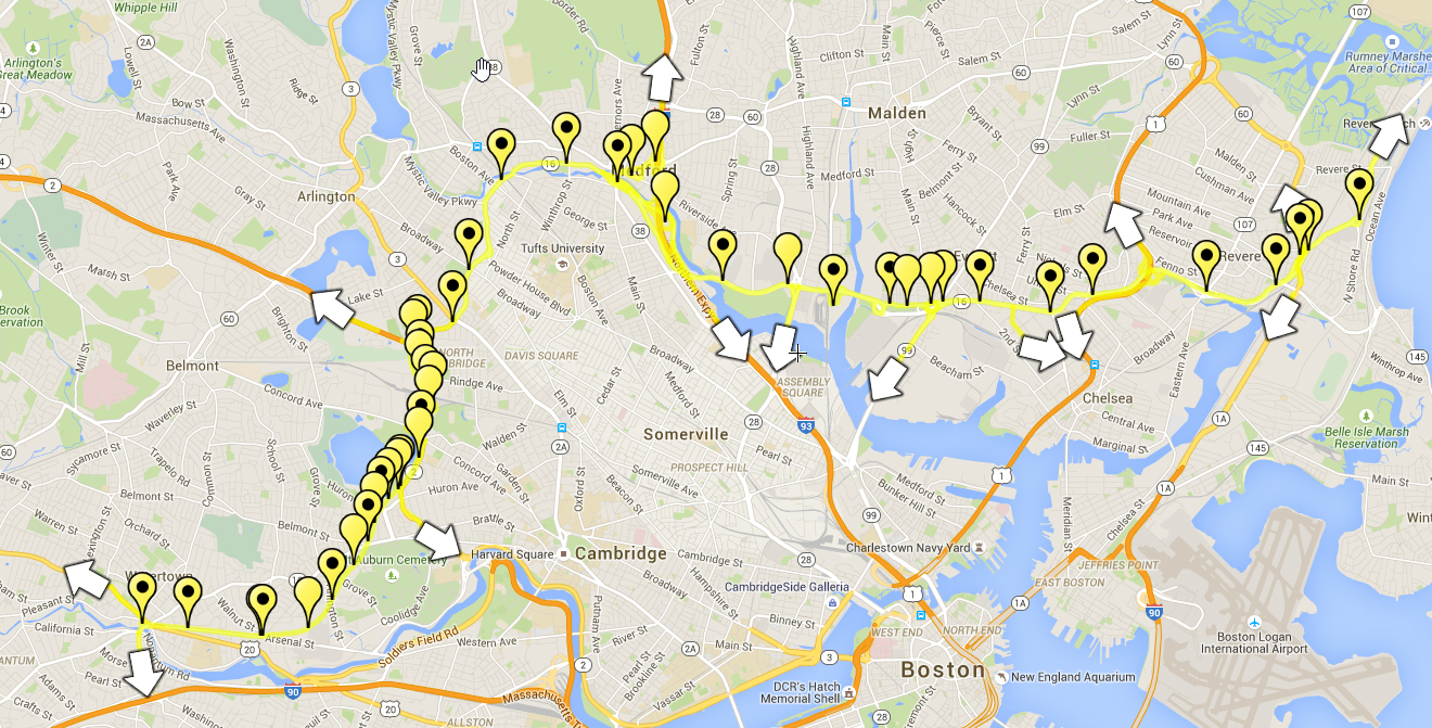
Route 16 BRT (Yellow Line)

First off, I have to say this more of an 'off the cuff' crazy transit pitch idea, and a "let's sip some beer and play with scribblemaps on a Saturday night". I say this because I did much of this freehand, and designed this with the idea that everything would be 100% OK, no real roadblocks. (OK we can just call it a pipe dream)

This whole concept stems from a comment I made in another thread about why Route 16 (mainly Revere Beach Parkway) does not have BRT on it. So I expanded on that concept some and mapped it out.

I originally was just going to run it from Wonderland to Alewife because the road could handle BRT nicely with some minor upgrades and station additions. But once I go to Alewife, I decided to run it further to Watertown Square via a busway.

Main points of new BRT line

1. Crosstown connector for the immediate northeast, north, and northwest suburbs where little crosstown service exists
2. Provide service where almost no existing service exists
3. Provide connecting service to many existing bus lines
4. Use current infrastructure (major roadways) with minor changes (with little money)
5. Show possible connection with future MassDOT projects (SLG, UR, GLX, etc)
6. Spur ToD around new BRT line
7. A fresh idea that uses sections from other projects, bus routes, and conceptual ideas.

Considerations (assumptions)

1. Connecting city centers along the BRT line
2. Road can accommodate bus lanes, and/or where they cannot, road can be widened to provide a bus lane (mixed or segregated)
3. Signal Prioritization
4. Station locations + grade + crossings are feasible
5. No community issues (especially beyond Alewife where a shared use path is converted to a busway + shared use!)
6. Headways and ridership would support such a route (a big one!)

Things NOT considered

1. Headway's (especially if route is TOO long for one long bus route)
2. Projected ridership numbers
3. Loop & Turn-out locations (except possible Medford & Watertown Squares)
4. Anything else nitty gritty about transit planning.. again this an off the cuff idea!

----

To see the full, zoom-able map click here

19057489778_5b53c74e68_o.jpg


--

Station & Connection List - Starting in Revere

Wonderland Station - This would use the current (new) busway at Wonderland Station. A extension to Lynn could be possible from this point via 1A and the Lynnway. Major bus transfer point. Connections: 110, 116, 117, 426, 441, 442, 450, 455

Connection Point - Possible connection point to MA 107 and US 1 Express buses.

Bell Circle Station - A split station, where one platform lives on the east side of Bell Circle near the CR tracks, and another on the western side of Bell Circle. I know.. horrible design, but without taking land or redesigning Bell Circle entirely, this was the best design! Connections: 117, 110, 426, 450, 455

Winthrop Ave Station - A center island platform in the median of RBP at Winthrop Ave. Connections: 119

Mill Creek Station - This would be a center island platform station in the median of RBP, similar to the future Washington Ave station on the GLX. This would require the entire interchange to be rebuilt however (and be one of the pricier stations in the project). Major Bus connection point. Connections: 116, 117 (key routes)

Connection Point - Possible connection point to US 1 express buses (and future Route 1 bus lane)

Washington Ave Station - This station would be a center island platform in the media of RBP near Washington Ave. This station would require a slight reconfiguration of RBP over US 1 to accommodate the new station. Major bus connection point. Connections: 111 (key route), 112

Everett Ave Station - This station would be center island platform in the median of RBP @ Everett Ave. Connections: 112

Connection Point - Possible connection point from SLG busway via Vine Street

Memorial Stadium Station - Side island platform station on the sides of RBP @ 2nd Street. Just before station dedicated median-based bus lane would end, and buses would crossover to new lane along the sides of RBP. This is done to accommodate on/off ramps from Sweetser Circle. Connections: none

Bus ramp - New bus-only ramp to Sweetser Circle from RBP westbound.

Possible Sweetser Circle Station? - Possible station here. Major bus connection point. Would require expensive major reconfiguration of rotary however!

Connection Point - Possible spur to new casino and Sullivan Sq station via Alford Street? (Urban Ring?)

Revere Beach Parkway Access Road (Bizzaro Lane) - This section would be widened to accommodate a new bus lane in each direction.

Santilli Station - This essentially would be beef up the current bus stops outside of BestBuy to be BRT grade (better amenities). This new station could also serve local bus routes. Ideally new walkway and pedestrian connections would be built on eastern side of rotary to shopping center also! Connections: 97, 99, 106, 110, 112

Wellington Station - This would use the current busway at Wellington Station. Ideally, when the new bus garage gets built (if it ever happens) a new BRT-only busway would be built along with this project. Major connection point. Connections: Orange Line, 90, 97, 99, 100, 106, 108, 110, 112, 134

Connection Point? - Possible spur down to Assembly & Sullivan Square stations (a la Urban Ring) via 28.

Fellsway Station - Possible station here, however would require major reconfiguration to current rotary and/or taking of properties (State Police or Shopping Center, depending on side). Connections: 100, 108 (nearby)

Meadow Glen Station - Side island station in median of MVP in front of the Meadow Glen Mall. Connections: 134 (at mall)

Connection point - Possible new station and connection point to I-93 express buses from Woburn & beyond? (Would require huge reconfiguraton of MVP interchange.) Alternatively, express buses could be routed via Medford Square (see below) via Salem Street Rotary and that intersection as a cost saving measure

Medford Square Loop - I couldn't decide if I wanted to do this or not, so I included it as a loop option (and possible turn-out). the BRT buses would bypass the next station (Medford Square Station), and loop on local surface streets around Medford Square (as many of the buses do today). This would provide direct connection to Medford Square (as a two stop ride from Wellington) and direct connections to local bus service. Connections: 94, 95, 96, 101, 134

Medford Square Station - Another more expensive center island platform. This would require recofiguration of the Medford Square overpass to build a station (i.e. Wash Ave GLX). This would give Medford Sq (if no loop) a station and connections to local bus service. Connections: 95, 96, 101

Winthrop Street Station - Center island platform station in MVP's median. Neighborhood stop, no bus connections

Route 16/Mystic Valley Parkway Station - This would be center island station below the future end of the GLX Route 16 station. This station would share the same name and provide connections to the Green Line. Connections: Possible Green Line, 80, 94

Clarendon Hill Station - This would be a center island platform station at the intersection of ABP @ Broadway in Clarendon Hill in the median. Connections: 87,88, 89

North Cambridge Station - This station would be built in the green space on the northside of the intersection of ABP and Mass Ave. Connections: 77, 350

Route 2 Interchange - Here's the big pipe dream. Re-work this intersection to include a bus-only connection to the Alewife Station Access Road from the intersection. If rebuilt as an 'at grade' intersection, signal priortization and dedicated busway would be needed here. (or ideally, flyover ramps). Also, a possible connection to Route 2 express buses (and future busway) could be made here.

Alewife Station - This would use the current busway at Alewife Station. Better station amenties would be added. This also would be the functional end of the 'fesiable' BRT plan.

---

Now onto the more crazy side. As I said before, After Alewife station is more of a pipe dream because it requires a few busways that are currently shared-use paths (they would be made into combo path + busway). I'm sure this would be an uphill battle to do but I decided to include it anyways.

From Alewife station there's two routes, a cheap route, which uses a bus lane on Alewife Brook Parkway to the Concord Rotary. OR build a busway starting at the end of Cambridge Park Drive Place, with a tunnel UNDER (diagonal) the Lowell CR line (and AND ABP overpass) to the Fresh Pond Mall's parking lot on the otherside. Then utilizing much of the parking lot to the left of the Mall for a new station ("Fresh Pond Station"), and a busway to the abandoned rail ROW behind the mall. This busway would then run in the ROW to the Concord Ave rotary.

Concord Ave Station - A station would be built in the green space on the southwest side of the rotary, and depending on if eitherside's connecting busways are built would determine what platforms style it is. Connections: 78

Busway - From the Concord Ave Station to about the Cambridge Water Department, again you could have two options, a busway along the current shared use path, or a bus lane on Fresh Pond Parkway.

Water Department Station - A station would be built on the southwestern side of the CWD's property. Depending on busways would determine it's exact location and platform layout. Connections: none

Connection Point - A possible spur could continue down Fresh Pond Parkway to Greenbrough Blvd and beyond from here.

Busway - From the CWD to Arsenal Street buses would use a busway along an ROW and shared use path. This would be converted to bus + shared use. No on street alternative exists.

Huron Ave Station - A center island station would be built at the northern end of the busway near the intersection of Huron Ave and Aberdeen Ave. Connections: 72, 75

Mt Auburn Street - A center island station would be built in the busway near the intersection of Mt Auburn Street & Trapelo Road behind Star Market. Trackless Trolley connections, 71, 73

Nichols Ave Station - A center island station would be built at the crossing of the busway with Nichols Ave. Connections: none, neighborhood station

Arsenal Street Station - A center island station built at the end of the busway near the intersection of School and Aresenal. From this point, buses would enter Arsenal Street in a bus lane (or mixed traffic) to Watertown Square. Connections: 70

Irving Street Station - A side platform station on either side of Arsenal Street. Essentially a beefy bus stop. Could also be used for local buses. Connections: 70

Watertown Square Station - Current terminus. Like all current bus stops, this would be upgraded with better amenties. Buses would loop around the square and return inbound. Connections: 59, 70, 71, 57 (nearby)

This is the logical ending of the BRT line, however two possible service extensions could be done from Watertown Square:

Extension to Newton Corner (and ideally Newton Center). This would run via Galen to Newton Corner, then Center to Newton Center (and the GL)

And an Extension to Waltham and 128 via the current 70 bus route.

----

That's it. Yes I know, a pipe dream, but I feel it would add some crosstown connections where there is none currently. Much like the Urban Ring, it could change the flow of passengers by giving a crosstown route to switch lines, rather than always going to downtown Boston.
 
i like it! kind of a very very long bus route though. Did you consider about splitting it in two at Wellington? I could also see a spur to Arlington Center on Route 60.
 
i like it! kind of a very very long bus route though. Did you consider about splitting it in two at Wellington? I could also see a spur to Arlington Center on Route 60.

Yes That's my fear. Well it's long for one contiguous bus line. I did try to mitigate most of the traffic woes which would slow down the buses, but it would require alot of work and almost an entire bus way (segregated lane) the entire length (it could be done tho!)

And yeah I didn't take in consideration the actual bus routing, but I assumed it would be Urban Ring-ish where you'd have to transfer at least once to do the complete bus way end to end.

Maybe it would be something like

YL1 - Wonderland <---> Wellington
YL2 - Wellington <---> Alewife
YL3 - Alewife <---> Watertown

And maybe run alternative longer routes (i.e. Wonderland <--> Alewife) during peak and more regular ones during off hours (when headway's are longer and can accommodate such a long route)

And then of course this just this busway, I put the "possible connection" arrows in there to show for future transit projects (BRT) that could use the busway also to kind of turn it into a major bus-connection-way-lane-thingy.

And again on the crazy side of things.. things like the noted connections to I-93 buses, either a station at the current interchange, and/or alternating, more frequent service (i.e. Woburn -> I-93 -> Yellow Line -> wellington or Alewife). This could provide supplemental service between certain points along the line.

And more general, just having many other buses (express, UR, etc) use the busway in segments would augment the long headway's on the buses that only serve the Yellow Line. Plus many of these future line bus lines (I-93, US 1, Route 2, etc) could all use the YL at some point (and probably just be spokes of this line also)

And as far as 60.. I was thinking about that also. Yes you could do a spur from where Alewife Brook Parkway starts at Mystic Valley Parkway up to 60, to Arlington Center, and probably out thru Belmont and beyond. You could even do this in theory from Medford Square via 60 to Malden Center. Then convert the rail trail (the "US Bicycle Route 1" trail) to a Busway + shared use from Malden Center all the way to Route 1 (and the future US 1 BRT line), then jump on to Squire to Bell and to Wonderland to complete the arc.

And 60, like RBP/MVP/ABP corridor would also benefit from a similar bus lane configuration as the yellow line. It's actually my second choice for a crosstown route similar to the my yellow line, however it would require a lot more work since 60 is narrow in many places and it would mainly have to be a 'mixed traffic' bus lane due to street geometry.
 
A Pitch for a car-less Boylston street, with surface transit

prep work:
Crazy Transit pitch involving moving the D and E branches into a separate subway.

Basic idea:
1. refurbish old Boylston street incline with tracks branching off the subway just past the sharp turn from boylston station
2. disallow automobiles on Boylston street from just east of Dalton street to, allow only buses and taxis on a small lane from Dalton St to Ring road, to serve the hynes center. Eastbound autotraffic would be rerouted onto Stuart St, Huntington Av EB (which becomes stuart st.), and maybe even Columbus Ave.
3. Lay down a two-way mixed-use transitway for buses and streetcars in what would've been the right and middle lanes of Boylston st, fenced off with some openings at stations, and for buses to turn onto regular streets. Pedestrian crossings would take the form of these fence openings, along with some pedestrian bridges over the transitway.

4. continue trolley trackage on Boylston in a loop through the Fenway/Park Drive, serving the various institutions and neighborhoods there, finally ending in the LMA at Longwood Ave and Avenue Louis Pasteur before looping back to the subway at Park St.

5. Turn the pedestrianized street and sidewalk and make it a linear park of sorts, with maybe even with a bikepath. Give this segment of street some odd name, like Backway


6: add other trolley lines , have stub track for short- turning around at Copley Sq.
Trolley ideas:
(originally the 55 bus) Fenway Park (looping around) - Copley Sq or Subway via Ipswich St.
LMA - Park St Subway via Fenway/Park Dr
Brookline Village via Ipswich St and Brookline Ave
Dudley Sq via LMA and Fenway/Park Dr (partial ring?)

New surface stops would be staggered inbound/outbound
Outbound
Boylston St at Berkeley St
Boylston and Dartmouth opp. Copley Square
Fairfield ST
Hereford St
etc...
Inbound
...
Boylston and Hynes Convention Center (actual center, not the station)
Ring Rd
Boston Public Library (Copley)
Clarendon St
Arlington St
-Incline to Subway-


Ignore the E line branching out of the portal.
2cyljia.jpg
 

Back
Top