Crazy Transit Pitches

Yeah...there's still trace vestiges of the old OL incline because they didn't immediately tear it down after the switchover into the new North Station tunnel in '75. The Green level got ripped up pretty good for Big Dig construction in '97-98 when they had to shift everything over to the Orange portal and the temporary El segment, so there's not a whole lot of the original Orange-level alignment left. There's still wide, wide open space in the Green tunnel after the new tracks curve off. Before they sealed the portal about 7 years ago and it was blocked only by a chain-link construction fence you got blasted by broad daylight for a couple secs while making the curve.

The new alignment cuts directly across the pre-1971 original Haymarket station, which was abandoned for the new one because of its dangerously narrow platforms. That open area full of misc. electrical boxes that the tracks now cross to get into the new tunnel was the old platforms.

What about the two stub tracks that are in there? What are those for? They look too short to store a Green Line trolley.
 
Allright, I just had to redo all this so it would fit on one page.

EDIT (again): All the lines won't display on one page. I included a "page two" separate map, so if you want to save them both to your places you can view both maps at the same time using the layers panel in the upper right. Not ideal but it's the only thing I can figure out.

mass(T)ransit: 2050

Page Two

I completely did my fantasy map to include my new concept of the Teal "Turbine" Line. Essentially it runs from Waltham through the Boylston Street Subway, loops around the metro area, then runs back through the Boylston Street subway a second time before ending its run at Arborway. I love this because it combines the urban loop concept with rapid service through the Back Bay, eliminating the need for a second East-West line altogether. I even thought up a construction schedule that is independent of all other proposed extensions:

Phase 1:
-Construct Essex Street subway, connecting Post Office Square leads at Boylston to the South Station bus loop. Pedestrian concourse above connecting Boylston to Chinatown. The shortest new construction but the most logistically complicated due to the mess of tunnels in Dewey Square and utilities under Essex St.
-Extend silver line tunnel to Black Falcon Pier, station near Summer St Bridge.
-Sink Tunnel Sections beneath the Harbor connecting Black Falcon Pier to the pier at Logan.
-Construct an EL from the logan pier to Airport station (to be renamed). Elevated station on west side of Central Parking. Possible station at Logan Pier.
-Cut and Cover Comm Ave subway to Union Square, Allston (single station stop)
-Extend trolley service as new (A) branch along completed project.

Phase 2:
-Extend El across Chelsea Creek, descend to existing ROW between Eastern Ave and Cottage Street. Station in this area.
-Extend at grade, swinging north under RT 1 and west towards RT 16. Station at Chelsea Station.
-Ascend to an elevated over RT 16 , station at or near Ferry Street. Continue EL across Mystic River, descend to at-grade station at Sullivan Square utilizing abandoned western tracks.
-Cut and Cover Comm Ave subway to Brighton Landing (station stop)

Phase 3:
-Cut and cover beneath the inner belt to Brickbottom, connection to Green Line.
-Cut and cover beneath the Grand Junction to the MIT athletic fields. (cut an cover is paramount, as I believe the GJ should be reserved for commuter trains to north station.)
-Stations at Cambridge Street, Reardon Square (pedestrian concourse under Broadway to Kendall), Mass Ave and Cambridgeport (near the atheltic field terminus)
-Cut and Cover under N Beacon Street to the other side of the pike, ascend to an elevated to cross the Charles. Descend into pit under the Arsenal Mall with a station stop.
-Cut and cover beneath Arsenal St and the Watertown Branch to Watertown Square. Stops at School St and the square.

Phase 4:
-Cut and cover from Courthouse Station to Washington Street, beneath Haul Road, Mass Ave connector and Melnea Cass.
-Demolish and cut and cover beneath the projects near Ruggles
-Cut and cover beneath Ruggles Street
-Station stops at Channel Center, Dorchester Ave (pedestrian concourse to Broadway utilizing former trolley tunnel), Mass Ave, Washington Street, Ruggles, and Huntington Ave.
-Extend (C) service along this routing.

Phase 5:
-Construct TBM launch boxes at MIT atheletic fields and the Landmark Center.
-dig station caverns beneath BU Central and Fenway.
-Deep Bore to connect both sides of the loop.
-Cut and Cover from the Pleasant Street portal to Huntington Ave along Marginal Road. Reroute the (E) here.
-Cut and Cover Huntington Ave subway to Brookline Village, swinging through Mission Park and the Brookline Ave playground to avoid deep boring.
-(A) and (C) now both loop, forming the turbine.

-Phase 6:
-Begin conversion of Boylston Street subway to Heavy Rail. Disconnect the Boylston curve, send all Tremont St trolley traffic [(D) and (E)] via the Pleasant St portal to the Huntington Ave subway. Turn the (C) at Kenmore and the (B) at Packards Corner (or Kenmore if surface routing remains intact).
-As an open cut extend the watertown Branch to Waltham, with a small yard beneath the common.
-Cut and Cover from the Brookline Ave playground beneath the Jamaciaway to the Heath Street Loop. (station stop)
-Heavy Rail begins, terminals at Waltham and Jamaciaway (Heath St) Cars would be blue line equipment, allowing the existing overhead to be used for power until end of life requires conversion to third rail

Phase 7:
-Deep bore beneath S Huntington and Centre St to Arborway. Station Stops at Perkins St, Pond St, South St and Arborway.

Phase 8:
-Cut and Cover beneath Lexington St and Totten pond Road, stops at Waltham Highlands, Piety Corner, and Prospectville.
-New at grade ROW under power lines to Trapello Road. Park and Ride for I95 and RT 2 at or near Trapello Road.

Success!

I think phases 1-6 could be done in 25-30 years. Phase 7 and 8 are independent extensions that would be provisioned for, but not a part of the core project.

1. Orange Line to Needham is an absolute waste of everyone's time, energy and money thinking about. Cutler Park is simply too large of a gap in heavy rail serve for any immediate consideration. If Needham were approaching the 100K range in population then maybe just maybe would that work.

2. I really can't take seriously any plan that relegates the B line to secondary or tertiary status - it's by far the most traveled of the inner-suburban-to-Boston corridors yet it is the one that sees the least attention overall - what gives?
 
Last edited:
What about the two stub tracks that are in there? What are those for? They look too short to store a Green Line trolley.

Probably work equipment for the overnight shift...wire car, flatbeds, hi-rail trucks, etc. It's a place to move that stuff into position and clear the mainline when they're shuttling something else. Doubt you'd ever see it occupied during the service day because except for that re-railer LRV permanently parked near Arlington they usually only store stuff at stations with an inspector hut in eyesight (Boylston, GC/Brattle Loop, NS Yard, Park pocket track).
 
1. Orange Line to Needham is an absolute waste of everyone's time, energy and money thinking about. Cutler Park is simply too large of a gap in heavy rail serve for any immediate consideration. If Needham were approaching the 100K range in population then maybe just maybe would that work.
This is my full build, no further expansion needed for another century outside of super hard to build (aka Allston> Brookline Village or Harvard > Union via Inman) projects. To serve people commuting into Boston, the Orange Line doesn't need to go beyond West Roxbuty in any direction. But you have two lines coming in from the north, so it seems logical to have them split again at the other end. You can't go south from Forest Hills to Readville due to the NEC, so it seems logical to follow the two ROWs you can from W.Roxy onward, especially since they have connections to a different line at their termini. That is the main reason: I don't forsee people taking the Orange Line from Needham into Boston, but I could see someone in Rolsindale wanting to get to Newton without having to go all the way downtown. It just increases your connections without forcing everyone to go to the central hub. Plus, especially in the case of Cutler Park, its a dead straight run for three miles. Even with an intermediate stop or two, the trains (probably automated by this time) could cruise top speed down the line.

Also notice I have a few other "everything else has been done" expansion proposals: Lynn practically has a subway system of its own, with the Orange Line terminating at Nahant and the Blue Line looping around forming its own transportation system. I did something similar with Waltham as well. I'm still working on Quincy in this respect. I feel that these three satellite city's will start to become hubs of their own, and having lines criss cross to form intercity trips in these areas will begin to be important to their continued vitality. I paid the most attention to Lynn as it is not only the largest, but also has Beverly, Danvers, Salem, Peabody and Saugus as potential suburbs of its own should it ever recover its former glory.


2. I really can't take seriously any plan that relegates the B line to secondary or tertiary status - it's by far the most traveled of the inner-suburban-to-Boston corridors yet it is the one that sees the least attention overall - what gives?
I have a big issue with the entire one-seat-ride mentality, as it severely limits the potential service. The B, and reinstated A both go to Harvard Square, providing connections to the Teal Line to downtown Boston, as well as the Red Line at Harvard. This connectivity should be more than enough to satiate any malice towards having to do a cross platform transfer at Packards Corner to continue downtown. You will also have much, much, much better headways and capacity on an actual heavy rail subway from Packards east then you would on any trolley system. The Turbine proposal also gives you a zillion possible destinations once you are actually on it.

I mean think about it:
If you are taking the commuter rail in you are most likely getting on the subway at north, south or back bay stations. From there you are also likely to have to transfer to another line or bus downstream, and perhaps another after that if your commute really sucks. This doesn't include the drive or bus to the originating station to begin with. So best case scenario you've got two transfers, probably closer to 3-5.

If you are taking the subway in from the outlaying areas you are looking at the same thing Bus>Subway>another subway/bus and onwards. Even if you are lucky enough to live within walking distance of a subway stop, you are still probably going to have to transfer to another line or bus somewhere downstream.

The trolleys are slightly different. Except for the D (which would be upgraded to heavy rail anyway), the stations are closely spaced and lack parking or substantial bus connections (excluding Harvard Ave and Reservior, which have excellent connectivity), so you are most likely walking. The trolleys actually are pretty good at hitting everywhere you need to go downtown, but with the exception of crowding and delays due to the subway jamming up. The trains are also woefully undercapacity for the function they serve. My point being, you may get a one seat ride, but it is crowded and slow. Without substantial construction you won't see more than three car trains (maybe four for special events) ever. A four car blue line train has SO MUCH more room then even a six car trolley consist, which you couldnt do anyway. They are also faster to board without stairs or narrow doorways and awkward seating patterns.


To summarize: the trolleys should be feeders, NOT core transit. The B west of Allston does not need rapid transit, and even if it did the hills would be murder to tunnel through, there are too many grade crossings to make at-grade running feasible, and an EL just isn't happening. The teal line will also pick up the great majority of Allston traffic, as the stations are closer to the origin points for the crowd that gets on at Harvard Ave and mobs the 57 past Union Square.

The B also has redundancy for much of its route with both the C and reinstated A. Also, you are gaining the tremendously important connection to Cambridge. Honestly my bigger fear is that this Allston>Harvard connection might overwhelm the trolleys in a similar manner to what happens through BU today.


^Ugh, that was supposed to be a quick response.

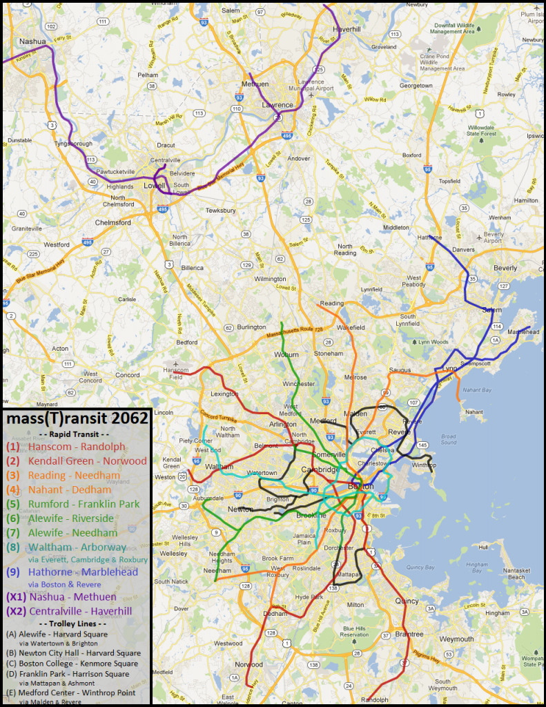
Edit: Making this longer because I made a map:
massTransit2062_zps3979a743.png
 
Last edited:
Davem said:
This is my full build, no further expansion needed for another century outside of super hard to build (aka Allston> Brookline Village or Harvard > Union via Inman) projects.

How are these any more ambitious than your large-scale cut-cover projects?
 
How are these any more ambitious than your large-scale cut-cover projects?

The Everett subway pretty much has to happen. It's expensive and disruptive, but there is no other way I can see to get rapid transit into this massive hole in the system.

The Lynn cut and cover projects are, with the exception of the downtown part of the Orange Line, smaller streets with residential houses with setbacks. You could tear up the streets with (relativity) light disruption.

A lot of the other cut and cover (teal line, etc) is under either railroad ROWs or cleared land for unbuilt highways. Lots of room to dig there. The exception is the green line to Dudley/Franklin Park. But again, glaring hole in the system, formerly supported an EL, worth it in the end.

The hard parts of the Teal Line (Essex Street, Cambridgeport > Longwood) are the same as Everett: have to happen. Its the urban ring, much needed, no other way around it. Its like setting a bone, hurts like hell but it ya gotta do it.

The other two projects would be great, but they are not critical. I'm trying to think as logically as possible in laying out this system, and I don't think you would get a sufficient ROI for those projects. It would be awesome to have a subway under Harvard Ave, but its one of the oldest roads in the area. There is god knows how much buried underneath, plus it goes through some tiny village centers and hills the whole way. Harvard > Union via Inman may be more doable then I give it credit, but with the Grand Junction right there and the complexity of getting out of Harvard eastward, I don't know if it would work.
 
Here is a Cambridge transit pitch:

Phase 1 - Restore the Grand Junction Railroad for at least some Framingham/Worcester Line runs to North Station with an intermediate stop at Mass Ave (MIT).

Phase 2 - After Lechmere has been relocated, use the current Lechmere footprint as a portal to a Green Line branch under Cambridge Street with station spacing ~ .4 miles. Stops include East Cambridge, Willington-Harrington, Inman Square, Mid-Cambridge East, Mid-Cambridge West.

Phase 3 - A new heavy rail line dubbed the Brown Line running along the Charles River, partially under Memorial Drive, mostly between Memorial Drive and the river. It would enter Cambridge from Boston (from riverbank subway, probably) in a bride or tunnel west of the BU Bridge/Grand Junction bridge and continue west on Mount Auburn Street into Watertown. Stops include Cambridgeport, JFK and West Cambridge.

Phase 4 - Extend the new Green Line branch to connect to Harvard Station and JFK Station.

Link:

http://maps.google.com/maps/ms?ie=UTF&msa=0&msid=210893109835316202405.0004d34231308f495a507
 
To summarize: the trolleys should be feeders, NOT core transit.

This is where I think a lot of people will disagree with you. With new signalling, the current Central Subway/Tremont Subway system can carry a lot more traffic than it does quite a bit faster. New trolley cars can't have quite the capacity of an HRT train, but the stairs/narrow boarding doors can be mitigated in the design phase (and have been to some extent even in the Type-8s.

The advantage of trolleys is that where an HRT line is difficult/clunky to branch, trolleys can go all over the place. They can run in old ROWs through the suburbs, they can run in medians, and they can run on streets. They can also make much tighter turns than HRT can. In addition to all of that, they're much cheaper and easier to build. All of which means that they can serve a tighter net. When F-Line talks about the "streetcar feeder" role of the GL, he has an excellent point. Boston is lucky and unique among big cities in that it has a pre-built LRT tunnel system to allow its streetcars and assorted light rail trains to serve Downtown efficiently (look at Portland for an example of the alternative), and partly due to that the Green Line is the busiest Light Rail system in the US.

I'm all for some additional subway tunnels, and the Huntington-NEC-Greenway routing seems to make the most sense from that perspective. However, I think someone should make a map of what a really good expanded Green Line could look like. I may try to do that.

A competently managed and properly built/expanded Green Line could quite easily handle a dozen streetcar spinoffs at 10 minute headways each. The problem is that none of those branches can be anything OTHER than streetcars, or the whole system breaks.

Yes, dirty politics surrounding the introduction of the D branch played a role in causing the Green Line to hemorrhage branches way back when, but I reject the argument that it was the only cause, or even the largest cause. Similarly, I reject the argument that everything will be just peachy if we start spinning new branches of the [Red/Orange/Blue] Line out of every Green Line extension that would have, should have, could have otherwise become a cohesive HRT Green Line.

Yes, with CBTC and proper investment, the available capacity on Red/Orange/Blue is going to explode, so if that happens, there's not going to be a real problem with new branches. But the key word there is "with" - and unlike the Green Line, where an unfunded mandate for CBTC looks more and more likely to be passed down with each and every collision or other 'accident,' there's no real danger of the MBTA being told it isn't allowed to keep dragging its feet on modernizing the signaling systems of the HRT lines, which instantly destroys the feasibility of new branches from everywhere to everywhere else.

Granted, converting Green remains inextricably linked to either the Riverbank Subway or any other method of getting around the existing and untouchable Central Subway, or at least, the part of it between Park Street and Government Center - so the most likely outcome is and has always been "nothing happens for another 20/30 years." Despite that, I maintain that provisioning for HRT Green (and LRT Silver) is going to pay off a lot better in the long run than provisioning for branching the Orange Line at North Station and extending the Blue Line to Riverside via Riverbank and Kenmore will.


Not to be a broken record on this, but how do you know HRT service is even warranted in place of the current Green Line? Downtown Boston has 3 HRT transit tunnels, and the current GL tunnel isn't geometrically capable of handling HRT trains for many reasons, one of which, the Boylston curve, isn't going away if you simply rebuild the line. Many people have designed reroutes that include Essex and Tremont St. tunnels to handle that problem, but that's a huge expense to fix... what problem exactly?

Your primary issue here seems to be that in your ideal Boston transit system everything is heavy rail, not that any long corridor currently served by the Green Line could be much better served were it underground. Everyone seems to be in agreement that the BU stretch of Comm. Ave. fits that requirement, and there also seems to be consensus that while the C-Line stretch of Beacon St. would make an excellent HRT line (dense, straight, and easily constructed underneath the current tracks) it also makes an excellent streetcar line. The Brighton HRT spinoff has some promise, but there's no real reason that has to be Green Line branded or routed through the current GL tunnel system. On the north side, there is not one good reason that GLX as heavy rail needs to be Green Line. None. None at all. You have a romantic attachment to that idea because you consider it unseemly for a large city transit system to have streetcars underground in the CBD.

Even the alternative you list - Orange on GLX and Blue to Riverside - involves unnecessary conversions, since Blue Line to Riverside really solves no problem. It gets people in Newton Center to Boston a little faster, but it costs a series of Newton villages neighborhood cohesion, probably obsoletes Eliot Station (since a station were you can't cross the tracks at grade there is pretty much physically impossible) and forces any extension to Needham to be HRT, which is bad for the corridor and neighborhoods it serves while precluding any rail-and-trail build parallel to Needham St. in Newton, which frankly would be great for local connectivity. A Riverbank Subway extended beyond Kenmore really should go into Brighton or Brookline, and again, none of this requires replacing the Green Line.

My argument in favor of a funcitonal Light Rail system with a subway element has nothing to do with "politics involving the introduction of the D Line." It has to do with the fact that Light Rail can serve corridors and markets that Heavy Rail cannot, and is a crucial complement to the Heavy Rail system. My argument is that Boston should not spend tens of billions of dollars to negate an existing functional and highly valuable resource simply because "it looks amateurish to have streetcars running in a tunnel," or "this route deserves HRT in 2040 because in 1940 people thought it would deserve it in 1960."
 
Not to be a broken record on this, but how do you know HRT service is even warranted in place of the current Green Line? Downtown Boston has 3 HRT transit tunnels, and the current GL tunnel isn't geometrically capable of handling HRT trains for many reasons, one of which, the Boylston curve, isn't going away if you simply rebuild the line. Many people have designed reroutes that include Essex and Tremont St. tunnels to handle that problem, but that's a huge expense to fix... what problem exactly?

Your primary issue here seems to be that in your ideal Boston transit system everything is heavy rail, not that any long corridor currently served by the Green Line could be much better served were it underground. Everyone seems to be in agreement that the BU stretch of Comm. Ave. fits that requirement, and there also seems to be consensus that while the C-Line stretch of Beacon St. would make an excellent HRT line (dense, straight, and easily constructed underneath the current tracks) it also makes an excellent streetcar line. The Brighton HRT spinoff has some promise, but there's no real reason that has to be Green Line branded or routed through the current GL tunnel system. On the north side, there is not one good reason that GLX as heavy rail needs to be Green Line. None. None at all. You have a romantic attachment to that idea because you consider it unseemly for a large city transit system to have streetcars underground in the CBD.

That isn't my premise at all.

My premise is that the needs of a functional streetcar network are entirely different from the needs of a functional HRT line, and that trying to couple the two together leads to problems.

The stretch of the B that serves BU is also a part of a revived A and/or service into Brighton, both of which are excellent candidates for HRT. On the northside, GLX anywhere past West Medford starts looking better and better as HRT the further north you go - especially since the inner Lowell line can't be high-leveled without ripping it apart and reconstructing it, and once you're into that expense you might as well send GLX up there because it's going to cost you about the same as rebuilding every station between West Medford and Anderson RTC would and you get far more bang-for-buck on a real-deal transit line instead of EMUs.

I also don't want to replace the existing Central Subway, and in fact, I pointed out the Central Subway being irreplaceable as one of the main reasons why HRT Green can't go forward today, tomorrow, or any time before we have an alternate route for it that leaves the Central Subway intact for the streetcar network.

I'm not trying to destroy LRT in the City of Boston. Really, I promise, I'm not. Nor, for that matter, do I consider it "unseemly." It serves a valuable and a vital role, and I do recognize that. The problem is that trying to couple useful HRT routes to the streetcar network as more LRT branches hurts both - the otherwise-HRT route because LRT trains just can't meet its capacity demands, and the streetcar network because all of the capacity that would otherwise be going to more streetcars is being sucked into the gravitational black hole that is the otherwise-HRT "branch."
 
Not to be a broken record on this, but how do you know HRT service is even warranted in place of the current Green Line?

I just ran some numbers to answer this question (regarding ONLY heavy rail conversion from Boylston to Allston, with an extension to Waltham, the rest of the green line would remain trolleys using the pleasant street portal and huntington ave subway):

Weekday bus boarding's both directions along redundant routes:

#57 Watertown Yard - Kenmore Square
11504

#70 Cedarwood - Central Square
4654

#70A North Waltham - University Park
2032

#71 Watertown Square - Harvard Square
5483

#170 Waltham - Copleyish
42

#502 Watertown Yard - Copley Square
1212

#504 Watertown Yard - Federal/Franklin St via Copley
1568

#505 Waltham Center - Federal/Franklin St via Copley
912*

#553 Roberts - Federal/Franklin St via Copley
695*

#554 Waverly - Federal/Franklin St via Copley
667*

#556 Waltham Highlands - Federal/Franklin St via Copley
462*

The asterisk numbers I halved, as they travel from Waltham through Newton to get on the Pike.

Also, I did not include any of the express buses running out of Brighton Center, despite my belief people would walk down Market St to take heavy rail.

I DID include busses running into Cambridge instead of Boston. My idea being that some of this ridership would prefer a subway to a bus despite it not going closest to their destination, as well as the assumption these people may be riding the red line into Boston anyway, and also to even out not including people who are taking the commuter rail, or who drive, or who wouldn't consider this commute realistic with a bus.


Weekday boarding's along redundant B Line stops:

Allston Street 1115

Griggs Street 1260

Harvard Ave 4077

Packards Corner 1571

Babcock > Blanford 12807*

I also halved these numbers, as stop consolidation would eliminate ridership due to my theory of inter BU trips.

Also note these are only boardings at these stops, not representative of people returning back from downtown. These numbers do include passengers going outbound however, so it may be a wash (I don't think so though, but it doesn't matter anyway)

So my barely scientific hurriedly estimated weekday ridership for a heavy rail subway line from Waltham > Downtown (Copley area, where most of the express busses stop)

7ish Miles Blanford > Waltham: 42290


5ish ish Miles Maverick > Wonderland: 31549


Now, I have NO idea if my estimates are anywhere close to realistic, low or high. But what I do know is that they just spent a ton of money lengthening the blue line platforms to accommodate six car trains. So if my estimate is anywhere even remotely correct, the Boylston subway and extension to Waltham is more warranted then the blue line from the harbor north.

Is my data sound?
 
I think someone should make a map of what a really good expanded Green Line could look like. I may try to do that.

One of my fantasy maps uses a very large LRT system that would need new designations due to the complexity.

Here it is with the remainder of that particular fantasy map.
 
So my barely scientific hurriedly estimated weekday ridership for a heavy rail subway line from Waltham > Downtown (Copley area, where most of the express busses stop)

7ish Miles Blanford > Waltham: 42290


5ish ish Miles Maverick > Wonderland: 31549


Now, I have NO idea if my estimates are anywhere close to realistic, low or high. But what I do know is that they just spent a ton of money lengthening the blue line platforms to accommodate six car trains. So if my estimate is anywhere even remotely correct, the Boylston subway and extension to Waltham is more warranted then the blue line from the harbor north.

Is my data sound?

I can't speak to the soundness of your data (although I'm impressed with the thoroughness of the admittedly gross estimate), but I want to play devil's advocate for a minute here, regarding your use of the Blue Line as a benchmark. (Please understand that I'm don't necessarily disagree with you, but I want to address a potential weak point in your argument.)

Your proposal calls for 4.5 miles of new subway under streets (Kenmore to Watertown Square), and then another 2.5-ish of tracks, either over- or underground along a basically extant, though inactive, ROW.

The Blue Line north of Maverick (when it was converted from narrow gauge to HRT), on the other hand, was a subway extension about .6 miles long, followed by nearly 4 miles of surface tracks, along a ROW that had been until recently active. Theoretically, they could've just added another rail in each direction (leaving the original narrow gauge rails as gauntlets) and strung up some catenary, and boom, they'd be done.

My point is that the Blue Line is a bit of an odd duck, in terms of HRT. Its construction costs were (theoretically) much lower than the Teal Line Subway-to-Watertown/Waltham you are proposing. Low-hanging fruit, kind of a low-cost-high-gain deal. (Whereas your Teal would be high-cost-high-gain.) Theoretically, the Blue Line today could still function as LRT à la the D Line (though it would have to be run more effectively than today's Green Line).

Take the Red Line as a different example; it's 5.5 miles from Charles/MGH to Alewife. Not counting Harvard, since it is such an outlier, you see ridership of around 65,000. (Harvard boosts it up to 85,000, fwiw.) Obviously that corridor is appropriate for HRT, so the question is where the Teal Line falls between the obviously-necessary-Red-Line-HRT and the odd-duck-Blue-Line-HRT.

I think a better benchmark to which to compare your data (at least, in terms of cost-effectiveness and justifications) would be the Red Line Northwest Extension to Alewife. You would have to adjust for distance, but I think that case is much more similar to your proposal than is the Blue Line.

*takes devil's advocate hat off*

On the other hand, your logic seems sound to me, and certainly seems to plan for the future, ie. even if the numbers are lower now, that corridor seems to have growth potential, so I bet you'd see the numbers rise in the years following its opening.

And Busses, that map is gorgeous. :-D
 
Riverside, excellent points on cost/benefit, especially on the relative ease at which the Blue Line was created in the first place.

My only question is why you included Charles, Kendall and Central in your ridership numbers?

Just Alewife - Porter is 30837.

Including Kenmore > Boylston bumps up my estimate to 89964, not including anyone who would transfer from the C at Kenmore. That's pretty damned close to 85,000 on the red line, even with a decent margin for error in my calculations (which I'm sure are horrendously flawed).

What I would love to see is some of the pre-extension bus ridership numbers to see if they compare.

Not in favor of my proposal is that is over 2.5 miles, wheras mine is closer to 7.

In favor is that that required deep boring from Porter to Davis, as well as completely tearing up Harvard Square and building a slew of temporary stations.

Not in favor is that my proposal crosses the Charles three times, one area in which there has not historically been a crossing.

I included Charles, Kendall and Central so that the length would be more nearly comparable to your extension.

In hindsight, what I wrote is a bit confusing; I was offering the numbers up just to offer some perspective on what ridership arguably should be on an HRT corridor, or at the very least, a number of riders per mile that we can say represents the point at which there is zero reason not to have HRT. I brought up Red NW because it's the only subway extension in recent memory that did not consist mainly of existing ROW, which, no matter what the method of construction, will almost always be less expensive and generally easier to manage than the alternative.

Some of the issues you raise about the Alewife extension comparison are addressed easily enough: theoretically, we can just convert the ridership per mile for each extension to compare them (like I did below). And since we're just throwing around vague numbers here, youcould argue that the costs of deep-boring and all the stuff at Harvard are probably in a general ballpark-range of cut-and-covering a longer distance through Allston, Brighton and Watertown. Though you're right, those Charles crossings do make it harder to do any comparisons...

You make a good point about how the Boylston Street Subway bumps up the numbers. Your Teal Line is about 9 miles long, so that's roughly 10K riders/mile, versus 5 miles of the Red Line, which is 17K riders/mile. That's still a big difference, but, on the other hand, those are still pretty big riderships, especially compared to Blue (30K/4.5 miles = 6.7K riders/mile).

Yeah, it would be great to have some pre-extension bus ridership numbers for north of Harvard. That would be an interesting analysis...
 
If street-running ever gets green-lighted, your map makes me realize the E-Line Loop could be a very useful ring (not exactly the full urban ring though) and provide important lateral connections. Huntington Ave --> Brookline Village --> Allston via Harvard St./Ave --> Harvard Sq via North Harvard/existing tunnel --> Cambridge Street via Inman back to Lechmere.

I'd also add that trolleys on main corridors like Harvard St/Ave and Cambridge St around Inman could probably be easily separated from car traffic if you're willing to lose car lanes and street parking. There'd probably be some overlap - e.g. turning lanes shared with the trolley tracks.
 
Idk If I told the forum this , but Alon Levy thinks the Canton Viaduct should be tore down due to it being in bad shape.... Apparently he thinks its in worse shape then any of the bridges with Speed Restrictions in Connecticut , New York , New Jersey or Maryland..... He also thinks using the Providence Bypass would be a stupid idea.... Sigh , hes only used the Northeast Corridor once and seems to think he knows whats best of the NEC. Hes calling the Amtrak Expansion plan a Boondoggle , but has no problems with the botched Cali HSR plan... Hes also against 4 tracking in Mass and Rhode Island even though its need for HSR and Freight operations to co-Exist....
 
Huh? I read his blog as well and I don't recall him saying anything of what you just rambled. Except for the fact that the Amtrak Vision plan is a boondoggle. And it is.
 

Back
Top