Crazy Transit Pitches

What would you say is an average width for a construction zone for a cut n' cover construction operation? A two-track tunnel could be around what at the minimum? 45'?
 
^ Perhaps an esplanade/storrow route would be more feasible after Charles/MGH, but like you said, a terminus at Kenmore would be sufficient enough, today and for a while.

For a long term plan (next 50+ years) I think maybe the outer burbs may possibly need something more in line with the capacity of heavy rail. I think keeping the ROW as is for the BL would be easy enough after its configuration thru Kenmore. Adjustments to station platform lengths and height should accommodate HRT on the D ROW. amirite?

Yes. You'd have to build footbridges at each station to eliminate the track crossings and lengthen platforms to 6 cars in addition to raising, but otherwise clearances are fine above ground. You may even want to ditch the 3rd rail and switch back to overhead here, because Blue can run unmodified on Green Line overhead and all D infrastructure could remain in place with appropriate power boost.

The only thing you can't do is a Needham Branch with grade crossings. And that's an expensive problem.
 
I'm not sure if it would be possible as it is a very narrow work space, but Back St. that runs along what a temporarily narrower Storrow Dr. may be the most effective, path of least resistance for a BL from Charles/MGH to Kennmore.

Tackling the Muddy River will be a challenge for sure. Perhaps there is a way to temporarily drain it. I don't know if there is a diverging path it could take via drainage systems or not. If not completely drain it, maybe there is another way to tunnel under it at a restricted flow volume. I'm sure the Romans could have figured something like this out.

The 1918-construction Green Line tunnel passes under the Muddy between Hynes and Kenmore where the tunnel curves off Comm Ave. diagonally onto Newbury by the Bowker ramps. It's a shallow river less than 100 ft. wide and not more than 3 ft. deep already channeled on both sides by granite and concrete walls, so there's no riverbank whatsoever here. Your box tunnel very close to the surface under Storrow would have to transition into a deeper (relative...it's still not that deep) bore between Mass Ave. and Charlesgate, and stay that way down Beacon St. on approach to the Kenmore lower level. But it's pretty much identical to how they built the GL Copley-Kenmore extension 95 years ago. Probably using temporary construction dikes to keep sides of the channel and bottom of the river watertight while they scoop underneath and pour the concrete.
 
10dcg0o.jpg


Because I am that bored today, I made some theoretical station signs for the the revamped system/map. I had to be sure to make one for you F-Line.

It's sorta NYC-esqe minus the black background. I think it works.
 
I've always thought it would make sense for the T to either number or letter the whole system. They get stuck in this stupid color coded convention and then we end up with things like the Indigo Line. Really? Indigo?
 
"Indigo Line" came about as an intentional similarity to the Purple Line (commuter rail) - a way to distinguish the DMU service from the loco-hauled commuter rail while still differentiating it from rapid transit.

Colors work pretty well on systems with less than about 8 lines. DC has red/orange/yellow/green/blue, with purple and silver in the works. Chicago has red/orange/yellow/green/blue/purple/pink/brown. LA has red/orange/yellow/green/blue/purple/silver plus the Expo Line (aqua colored) which I believe is to eventually through-run with one of the colored lines.

Boston's red/orange/green/blue makes a very nice map, plus the silver. The Urban Ring was likely to have become the Gold Line; silver for radial rapid bus and gold for circumferential would work very well. While white/brown/black have undertones that wouldn't get them approved, and yellow and purple are pretty set for the existing bus and CR systems, that still leaves options. Indigo is actually perfect for DMU ops - similar yet different from regular CR. Pink and aqua have been successfully used elsewhere, and yellow could be reused for a rapid transit line without severely compromising the bus system. That's four additional lines you could build before you really need to think about destroying a color system very set into the public mind.

That said, they should add end-of-line text bullets like DC has. That's a good way of making the map usable for people with colorblindness, while still maintaining identity.
 
I've always thought it would make sense for the T to either number or letter the whole system. They get stuck in this stupid color coded convention and then we end up with things like the Indigo Line. Really? Indigo?

Yea I agree, seeing that there are lines that don't fully travel their designated line (GL), and lines that split to separate terminals, which isn't that complicated to understand as 1 line that splits, but I think it makes for an easier to understand system if they were split into separate designations.

I remember when I moved to Boston a while back and hadn't gone to Lechmere before, but once I had to I never noticed how only 1 of the lines actually went there. It really doesn't to justice to the map, by saying that the Green Line is a line that goes to all these stations. The map I made is makes sure this is understood at least. Also the colors are still the same as they've always been. And putting the Green Line (except the D) on a map that states "rapid transit" is also misleading.
 
I've always thought it would make sense for the T to either number or letter the whole system. They get stuck in this stupid color coded convention and then we end up with things like the Indigo Line. Really? Indigo?

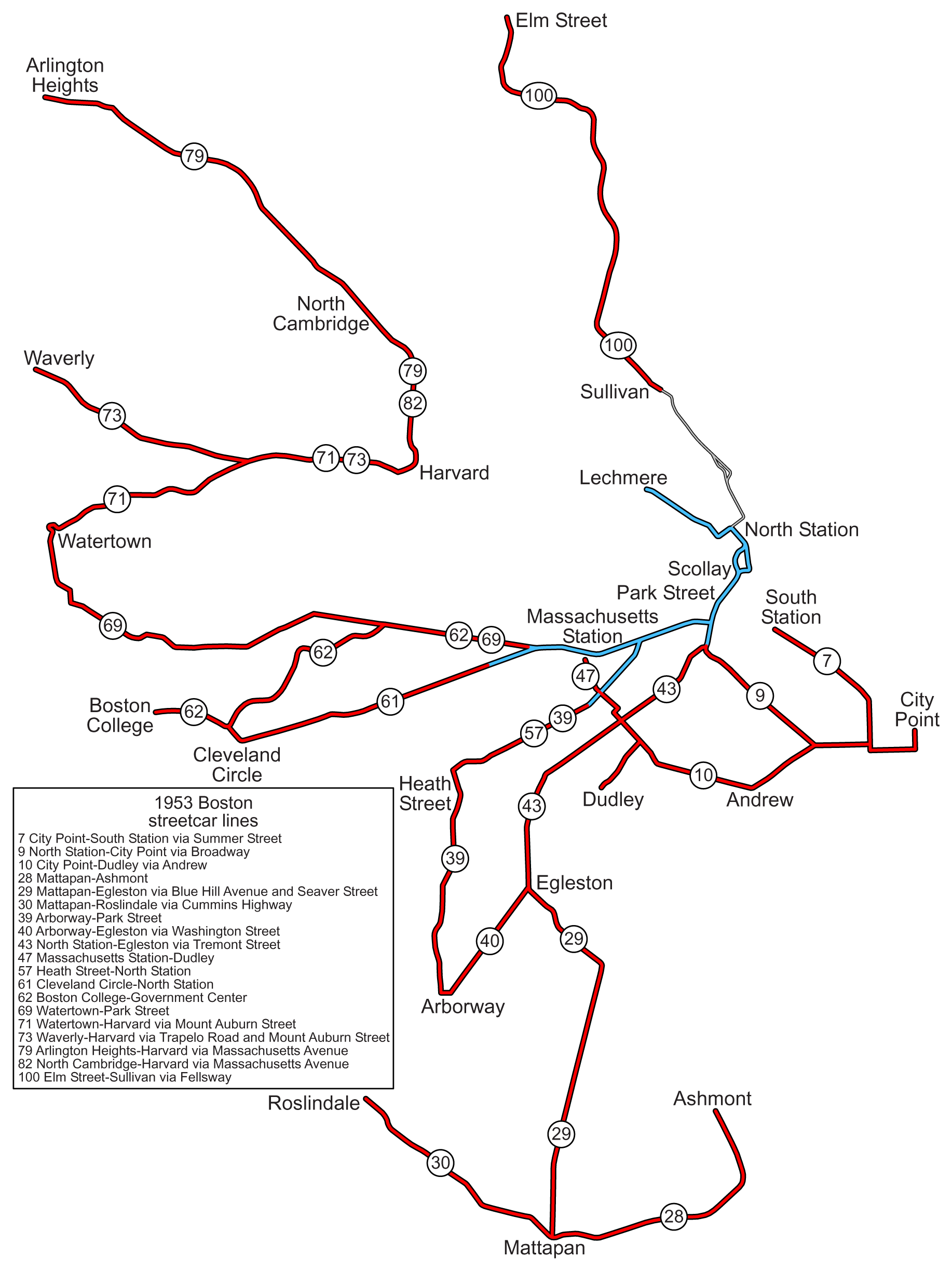
It's been done. . .

1953_Boston_streetcar_lines.png
 
When did the streetcars out of Lechmere into Somerville go away? Clearly before 1953, but was it very early on?
 
When did the streetcars out of Lechmere into Somerville go away? Clearly before 1953, but was it very early on?

July 9, 1922 is when they stopped running into the subway via Lechmere. The next day is when the East Cambridge Viaduct, and Lechmere Station opened. The streetcars still ran to Lechmere for another 19 years (until 1941), with a transfer at Lechmere Station to get downtown. You caught me at a good time as I was surfing through old streetcar line info earlier this week and bookmarked a lot of it. Haha
 
Really surprised that nothing took the place of the old Atlantic El, extending the #7 trolley could be an interesting project today. How did the streetcar work once it got to SS?
 
Until 1947, there were two tracks on Summer Street up to Atlantic Avenue; cars switched tracks on a trailing point crossover. After 1947, the double track merged to a single center track, which again ended just before Atlantic Ave.
 
Atlantic Ave. also used to have street-running freight trains with the single-track NYNH&H Union Freight line running directly underneath the El from North Station to South Station with sidings fanning out everywhere to local businesses. Made it a little difficult to mix modes on the street's footprint. That line remained in-service as the 'original' N-S Link until the north half was abandoned in 1960 and south half in 1970.
 
I made a geographical accurate map of the system map I did before. I made a layer that illustrates the areas of best connectivity or proximity to stations just to see what it would look like.

315ka3a.jpg
 
I'd get that Blue Line to Lynn and have Ashmont gobble up the Mattapan LR route post haste! :)

Love the aesthetic btw!
 
Those yellow spots seem awefully small. I live a five minute walk from central square and my house would be in a pale yellow, nearly white area of your map. People walk 3 times further without blinking an eye
 
^ yeah I thought they were kinda small, i'll hafta adjust it sometime.
 
Don't forget to add Union square and Wilson square stops to GLX. They seem to be missing.
 
I'd get that Blue Line to Lynn and have Ashmont gobble up the Mattapan LR route post haste! :)

Love the aesthetic btw!

Thanks! What should become of the old trolleys from that route? I was thinking about a street car loop in the S. Boston Waterfront District.

24e2ek7.jpg


It'd be a nice tourist thing to have there and help movement in the neighborhood I think.
 

Back
Top