You are using an out of date browser. It may not display this or other websites correctly.
You should upgrade or use an alternative browser.
You should upgrade or use an alternative browser.
Crazy Transit Pitches
- Thread starter BostonUrbEx
- Start date
JeffDowntown
Senior Member
- Joined
- May 28, 2007
- Messages
- 5,048
- Reaction score
- 4,226
Upon closer inspection of Washington between Herald and Dover there is NOTHING of substance on the west side of the street. A chinese food place, parking lots, and a warehouse. If there is a better place to widen the street for a trolley reservation, I can't find it.
--not to mention, with the ink block and that other development, this entire side of the street will likely be rebuilt within the coming years. Perfect opportunity to rebuild the street here.
The block at Washington and E. Berkley is spoken for. Drucker has a development approved for the block between Washington and Shawmut. Those "empty lots" are going away fast -- way too fast for any transit proposal to impact.
Shepard
Senior Member
- Joined
- Mar 20, 2009
- Messages
- 3,518
- Reaction score
- 69
If it's a single track loop you can easily take a lane on both Summer and Seaport/Northern. I don't even think that would be too controversial. And yes, I do think it would be faster than the 10mph underground rumble strip.
Needless to say, fixing the issues with the Silver Line and more to the point converting it to light rail and linking it in with the GL is 1000x better than this.
Needless to say, fixing the issues with the Silver Line and more to the point converting it to light rail and linking it in with the GL is 1000x better than this.
JeffDowntown
Senior Member
- Joined
- May 28, 2007
- Messages
- 5,048
- Reaction score
- 4,226
Eliot Norton park just isn't large enough to fit 300' platforms. What's the point in building a station if it is going to be functionally obsolete if four car trains happen? The whole reason I did this was as a proof-of-concept for your idea. In fact, the wedge was one of the first things I tried.
Looking at your map, I think you think the portal is further north than it really is. To roughly place mine, I looked at this map of the actual portal and where it aligned with the corner of Tremont and Shawmut, as well as historic aerials and some old atlases. I think I'm pretty close, within ten feet. Trust me, I didn't just pull my concept out of my ass. This is after about a dozen different iterations, plus a bunch of sketches by hand to see what might/might not work. For shits and giggles, here's what it was all looking at before I figured out the design I posted above.

One thought -- do you have to work with the exact location of the portal, or could you back up a bit under Tremont Street, to get a little more room for Tufts station. This would be a little more disruptive during construction, but Tremont is really wide there, and if you started the WYE earlier, you might get close to 300 ft.?
One thought -- do you have to work with the exact location of the portal, or could you back up a bit under Tremont Street, to get a little more room for Tufts station. This would be a little more disruptive during construction, but Tremont is really wide there, and if you started the WYE earlier, you might get close to 300 ft.?
As far as I can tell, the bellmouth that splits the two tracks to four is right at the turn where the subway goes off-axis from Tremont. So not without compromising that.
I have mixed feelings about this. On the one hand, I agree with Matthew - it's wasteful because it essentially serves the same area twice. You might make this a single track one-way loop, but that's been shown to have its own set of problems.
On the other hand, seeing this as a heritage streetcar line on the surface would probably be a transit improvement over the current BRT underground Silver Line. Maybe it could be funded and operated by BCEC, Fan Pier, Harpoon, Massport, etc.
I would make it a two-way loop, both clockwise and counter-clockwise. I think this would be a great use for the heritage trolley's if the Red Line take up the current Mattapan Line. I would like to see them used for more touristic purposes seeing that they are apart of the city's history and I would make them free to ride along this route.
If the GL and SL were to extend past S. Station, this would provide excellent connectivity in itself, however, this idea would be something meant to provide mobility within the district itself. With all the things to do there now, and what there will be in the future, this would be a good connector for all of them. With the cruise port, brewery, ICA, convention center, and BofA Pavillion all being major points of interest, the real convenience this would provide for is the numerous restaurants, bars and other places that will pop up once the thousands of residents and employees continue to move in.
And it should be free.

Last edited:
- Joined
- Jan 22, 2012
- Messages
- 5,078
- Reaction score
- 1,662
^ Honestly, the PCCs will be used for Greenway Heritage Trolley tourist trap stuff before they'd be considered for Seaport transit. Get a Heritage Trolley up and running between the North End and Dewey Square, then maybe continue it up through Charlestown Navy Yard and east into the Seaport if it does okay. This wouldn't be an MBTA venture. And it definitely wouldn't be free. Tourist traps never are.
That's true, I couldn't imagine the incompetent MBTA to do anything that would actually benefit anyone. It would have to be a collaboration among local businesses, camber of commerce, and Massport if this would ever happen at all.
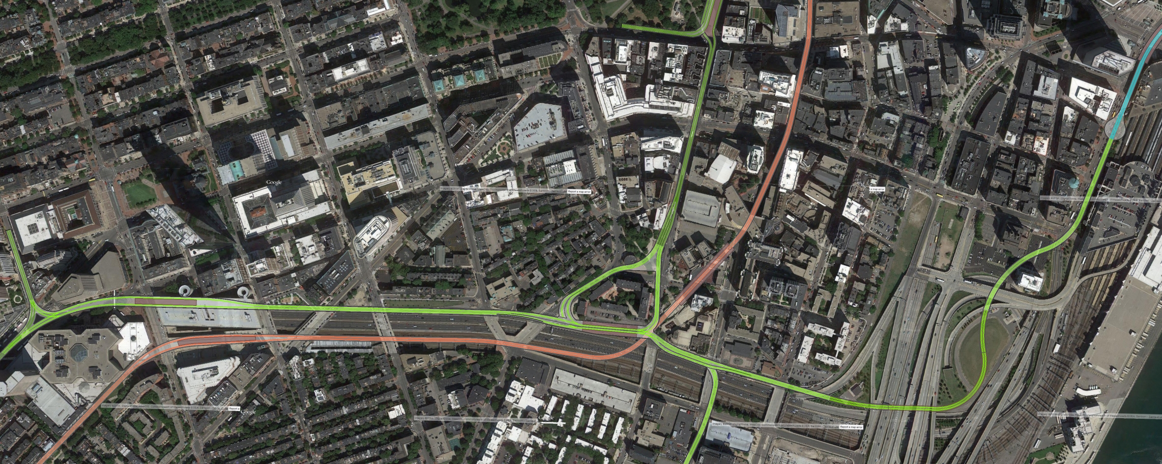
Soooo fixed some of the issues you guys picked out, as well as mapped out the majority of the extension. I didn't show most of the existing Boylston Subway because it would take for ever. The existing infrastructure is dark green new is light. Click the yellow bar for high(er) resolution.
--The new station at Back Bay goes under Dartmouth, so with any luck it could be used as a passageway from Copley Place to Back Bay station, getting rid of having to go outside there.
-I adjusted the curve radii. All curves are now over 90', which is still tight, but still better than Boylston. That's part of the reason why the platforms are no longer aligned with the Pike.
-The junction where the extension has to get over the orange line is now at grade. I have everything mapped out based on the assumption the orange line is low enough for this extension to go over it (since it's diving under the Pike), but they flyovers can easily be reversed if this is not the case.
-The station has side platforms instead of an island. Not a concession I wanted to make, however it allowed me to increase the curve radii, as well as have the eastbound platform dive down to allow a flyover on the west side.
-Not directly related to the station, but when connecting the new line to the Huntington Subway I realized that by creating a wye it would allow the former connection at Copley to be used to be used as bi-directional storage. Dudley/Seaport trains could also hit Back Bay and then go into the Boylston Subway, if that was ever a service pattern that was warranted.
-My routing to get into the transitway is a bit different then others I've seen. I have the line portaling to the surface as soon as it crosses under Curve Street, using the ROW of the service road that is there to get under the majority of the interchange, then curve north and dive deep to get under the depressed ramps. At that point it would go over/under 93 inbound before connecting up with the bus loop. I'm sure there are other routing possible, but this one involved the least tunneling as far as I could tell.
-I still have the Dudley branch portaling on Washington Street. It's my design, so MEHHH!
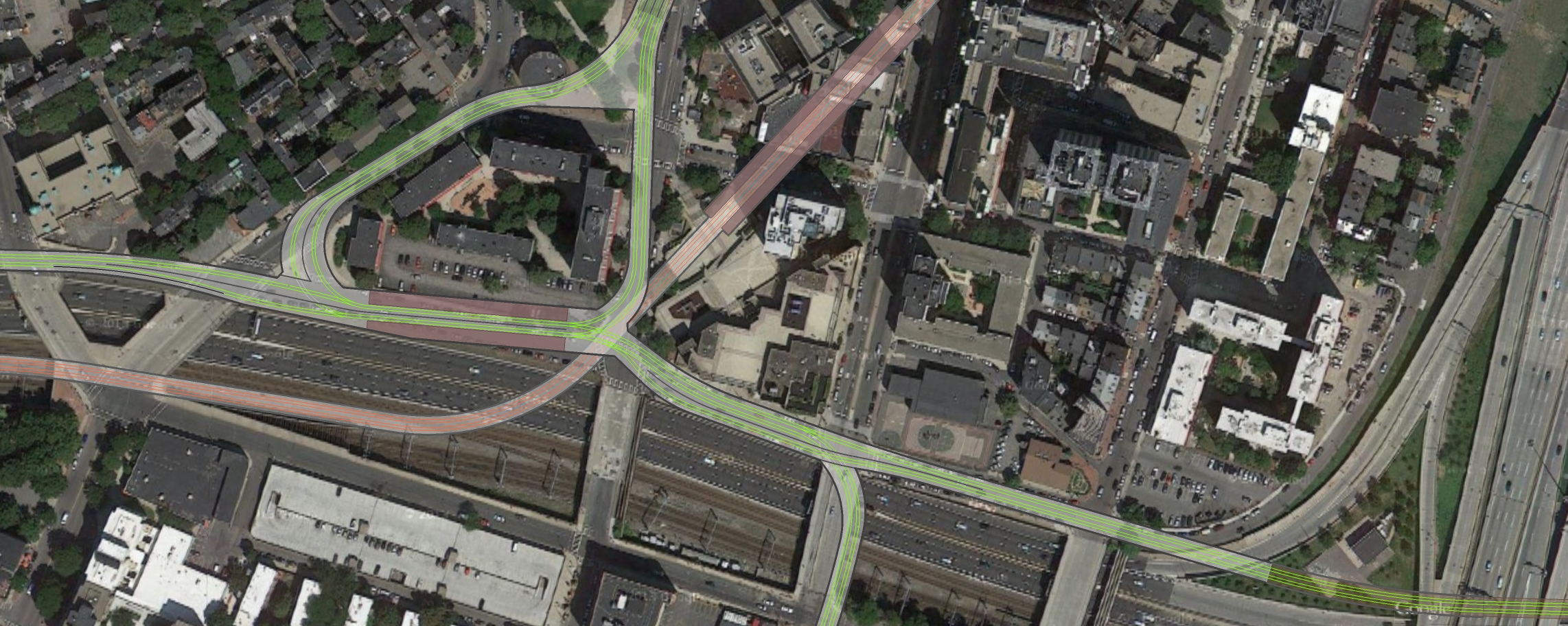
I didn't show the mezzanine level, but it would be under the platform level on the east side at the same depth as the Orange Line, so that a passage could run along the side of the existing Orange Line tunnel and connect with Tufts.
Also, I don't know why the one line is black instead of green. Don't care at this point.
Thoughts?
--The new station at Back Bay goes under Dartmouth, so with any luck it could be used as a passageway from Copley Place to Back Bay station, getting rid of having to go outside there.
-I adjusted the curve radii. All curves are now over 90', which is still tight, but still better than Boylston. That's part of the reason why the platforms are no longer aligned with the Pike.
-The junction where the extension has to get over the orange line is now at grade. I have everything mapped out based on the assumption the orange line is low enough for this extension to go over it (since it's diving under the Pike), but they flyovers can easily be reversed if this is not the case.
-The station has side platforms instead of an island. Not a concession I wanted to make, however it allowed me to increase the curve radii, as well as have the eastbound platform dive down to allow a flyover on the west side.
-Not directly related to the station, but when connecting the new line to the Huntington Subway I realized that by creating a wye it would allow the former connection at Copley to be used to be used as bi-directional storage. Dudley/Seaport trains could also hit Back Bay and then go into the Boylston Subway, if that was ever a service pattern that was warranted.
-My routing to get into the transitway is a bit different then others I've seen. I have the line portaling to the surface as soon as it crosses under Curve Street, using the ROW of the service road that is there to get under the majority of the interchange, then curve north and dive deep to get under the depressed ramps. At that point it would go over/under 93 inbound before connecting up with the bus loop. I'm sure there are other routing possible, but this one involved the least tunneling as far as I could tell.
-I still have the Dudley branch portaling on Washington Street. It's my design, so MEHHH!
I didn't show the mezzanine level, but it would be under the platform level on the east side at the same depth as the Orange Line, so that a passage could run along the side of the existing Orange Line tunnel and connect with Tufts.
Also, I don't know why the one line is black instead of green. Don't care at this point.
Thoughts?
- Joined
- Jan 22, 2012
- Messages
- 5,078
- Reaction score
- 1,662
I think the transit way can only be met under Chinatown Park where the busses currently loop. I'd have to look again at the maps f-line dug up from the big dig, but I think Your routing is totally off where the transit way goes.
I think the transit way can only be met under Chinatown Park where the busses currently loop. I'd have to look again at the maps f-line dug up from the big dig, but I think Your routing is totally off where the transit way goes.


Unless something changed...
bobthebuilder
Active Member
- Joined
- Oct 17, 2013
- Messages
- 434
- Reaction score
- 159
This proposal for the green line seems almost more reasonable than crazy. If the Fenway center development moves forward (which most of us agree it won't) what's the likelihood that this actually gets put on the table for discussion. The potential service down Washington and to the seaport through SS would be huge, at least in my mind. I would love to see this whole interchange happen.
FWIW, to handle game day/event traffic, I like c_combat's idea for BLX, at least to Kenmore.
FWIW, to handle game day/event traffic, I like c_combat's idea for BLX, at least to Kenmore.
Last edited:
Thanks to Bing's 'birdseye view' I found a much better routing for the extension through the South Bay spaghetti. Where it says "Dig small underpass under 93-N" it's really a slight enlargement of an existing underpass. The only large modification of the interchange is moving/combining the Atlantic Ave offramp over to make room for the new portal. Not too invasive though. Not only does running it on the surface through here save some money, but it is also the easiest as far as I can tell. I really see no reason this couldn't be done.

Another thing I was thinking about, is that the section from South Station to Bay Village / Tufts should be paved; allowing the dual modes to go all the way there. They could loop under Eliot Norton park. The same thing could be done for the Washington Street portal, allowing the buses to use it, since street running may not happen. The only issue I see is the buses slowing the trolleys down, so some sort of drive-by-wire would have to be implemented.
Sketchup, mostly because it imports Google Earth imagery at scale.
Another thing I was thinking about, is that the section from South Station to Bay Village / Tufts should be paved; allowing the dual modes to go all the way there. They could loop under Eliot Norton park. The same thing could be done for the Washington Street portal, allowing the buses to use it, since street running may not happen. The only issue I see is the buses slowing the trolleys down, so some sort of drive-by-wire would have to be implemented.
Dave, what are you using for these renders? Just curious...
Sketchup, mostly because it imports Google Earth imagery at scale.
winstonoboogie
Active Member
- Joined
- Dec 8, 2012
- Messages
- 541
- Reaction score
- 1
I-93 north is still descending at the point just south of the bus tunnel loop and takes up the entire width of Atlantic Ave. One of the emergency exits from the highway tunnel comes up under the bus terminal front pedestrian entrance on Atlantic Ave. If you were to continue the bus loop tunnel any farther south, you would immediately hit the roof of the descending highway tunnel, with no room for a portal with a reasonable grade (even for light rail).
The only way to extend or build a portal to the bus tunnel is from Essex St.
The only way to extend or build a portal to the bus tunnel is from Essex St.
I-93 north is still descending at the point just south of the bus tunnel loop and takes up the entire width of Atlantic Ave. One of the emergency exits from the highway tunnel comes up under the bus terminal entrance. If you were to continue the bus loop tunnel any farther south, you would immediately hit the roof of the descending highway tunnel, with no room for a portal with a reasonable grade (even for light rail).
The only way to extend or build a portal to the bus tunnel is from Essex St.
The s-curve could just be moved north so it comes up in the east side of the loop, or the loop could be blown up and replaced for the s-curve. I believe the ramp from 90W to 93N is pretty deep, so there should be room on top for this tunnel, no?
winstonoboogie
Active Member
- Joined
- Dec 8, 2012
- Messages
- 541
- Reaction score
- 1
The s-curve could just be moved north so it comes up in the east side of the loop, or the loop could be blown up and replaced for the s-curve.
The highway tunnel occupies the full width of the street up to the supports for the bus terminal building. No room to the east.
The highway tunnel occupies the full width of the street up to the supports for the bus terminal building. No room to the east.
There's that whole park. 93N is only the width of Atlantic Ave, so the only issue is the 90W-93N ramp, which I believe is pretty deep. The thing also doesn't have to be completely underground, it could just be in a cut. It just has to be deep enough so the Atlantic Ave ramps can get over it.
Edit: The 90-93 ramps is indeed very deep. Granted street view isn't perfect, but it doesn't merge until after 93N completes its decent, and the ramp is level.
winstonoboogie
Active Member
- Joined
- Dec 8, 2012
- Messages
- 541
- Reaction score
- 1
There's that whole park. 93N is only the width of Atlantic Ave, so the only issue is the 90W-93N ramp, which I believe is pretty deep. The thing also doesn't have to be completely underground, it could just be in a cut. It just has to be deep enough so the Atlantic Ave ramps can get over it.
The highway tunnel is under the park as well. There are emergency exit staircases from the tunnels coming up into the lower bus terminal lobby and there is another staircase at the northern end of the park. The tunnels heading north from the Southeast Expressway and East from the pike come together and merge under Atlantic at that point.
Edit:
Streetview image fom tunnel merge
https://www.google.com/maps/preview...m4!1e1!3m2!1sV6P6vVH3dUWgANGm11baMQ!2e0?hl=en
The highway tunnel is under the park as well. There are emergency exit staircases from the tunnels coming up into the lower bus terminal lobby and there is another staircase at the northern end of the park. The tunnels heading north from the Southeast Expressway and East from the pike come together and merge under Atlantic at that point.
It's not that I don't believe you, but are you really saying there isn't 10 feet down you can dig? As far as I can tell from crappy sources like streetview, the ramps are at least 20' down. A tunnel just below the surface or an open cut (perhaps covered with a raised platform or walkway from SS-the bus terminal) should fit. Emergency exits can be rerouted.
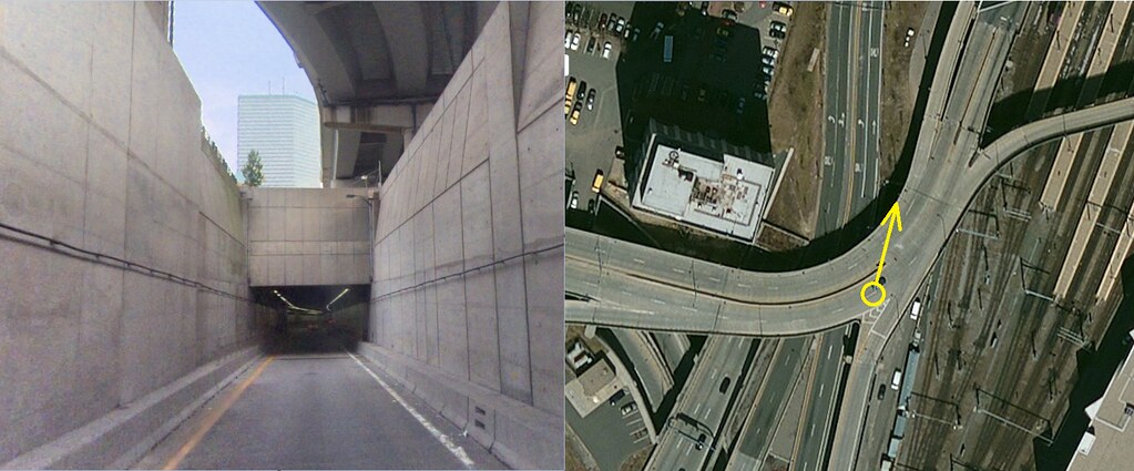
And note that if the Atlantic Ave ramps weren't an issue, this thing could just stay on the surface, using the former bus loop as the portal.
Last edited: