Eliot Norton park just isn't large enough to fit 300' platforms. What's the point in building a station if it is going to be functionally obsolete if four car trains happen? The whole reason I did this was as a proof-of-concept for your idea. In fact, the wedge was one of the first things I tried.
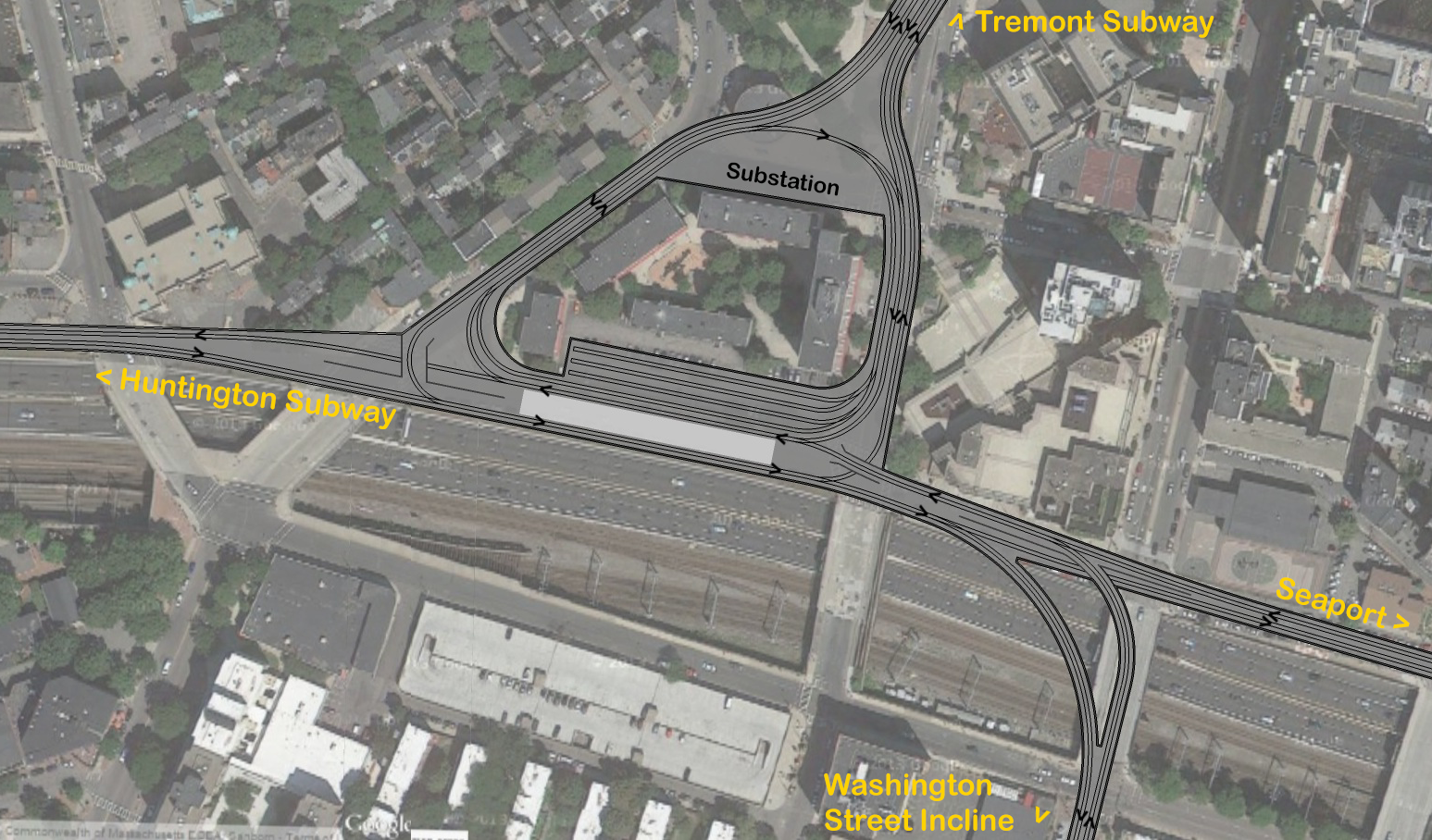
In reality, the usable space is less than that, because you can't have a platformed train fouling all the switches. Doing three islands won't work either for the same reason. To be able to through-route trains from Back Bay to the Seaport, the platforms can't be at the park (or at least not the one for BB-SS trains).
Then I think you're going to have to compromise because the Orange Line impacts are severe on Marginal. I do not think you can have 3 levels of tunnels crossing each other at angles in one spot with steep inclines as they pass. That Marginal/Shawmut intersection must be simplified a lot or this is a billion-dollar project easy with blockers that escalate to potential project fatality.
The easiest way to save it is to have one GL tunnel crossing the intersection at an angle and intersecting under the OL at a clean 90-degree angle. Anything else is going to be pure pain.
If this means you have a platform length issue at Tufts, so be it. You could try sweeping the platforms out at wider angles to cover more of the park area. GL low platforms work just fine on curves. But you're going to have to make some tough compromises with the abundance of flyovers and fluid perfection of all these around-the-block tunnels because so much stacked up around that bad-angle Orange crossing is killer. Bottom line is you have the open triangle there and you do not have open anything on the Tremont-Shawmut block of Marginal. If you have to push the limits somewhere, the park is it.
The yard I threw in because the parking lot is there, and to see if I could. Hardly mission critical. As for Shawmut and Marginal not being large enough for x tracks... they are. (Also I only have three tracks, two if you get rid of the yard) Granted google earth has a certain variance in how accurate it's imagery is, but its within a foot or two. The tracks are 4'-8.5" at 12' on center, which I believe is spec, plus an extra two feet of buffer space where the track is next to a tunnel wall. If it fits on that drawing, well, it fits in real life. The only abutter on this section of Marginal is also that single low-rise building, hardly much of an issue to deal with (some designs I came up with just demolished that building).
You can't go by the street footprint, because Essex's street footprint is plenty wide enough for a BRT tunnel but still proved a SL Phase III project fatality for building mitigation. You need generous buffers to have certainty the impacts are not going to spiral out of control. Look at Red-Blue on ultra-wide Cambridge St. That's about as ideal as it gets for tunneling under, and doesn't even require closing the right lanes of the road to build. But they still had some indirect abutter effects to solve. So I think if you're tunneling under Shawmut you need to keep the tunnel walls tucked inside the travel lanes with enough buffer that the parking lanes are outside the tunnel footprint.
It's not ironclad, but be prepared to tack $100M in contingency for pushing the envelope. It piles up really, really fast.
Similarly, Washington is 50' wide at this location. With a 26' wide portal (as on the E and B) that still leaves 12' on each side for travel lanes. Even better, if you have it portal 200' south of Herald st, there are two large parking lots behind the church that could be partially used to widen Washington at this point, giving even more room. No need for a short, steep portal and hard right turn onto Washington.
12' travel lanes with no shoulder are way too narrow. All 3 other portals pop up on reservations on roads with 4 lanes + parking lanes. The last portal Boston had that popped up straight onto street-running with no reservation was the ultra-wide block of Boylston between Charles Ext. and Arlington. Washington is way narrower than this. And if you are turning out on the side into a parking lot there's no way to get on-alignment into a parking lot without knocking at least one large building. It's too shallow to the surface to spare the foundations.
So chuck in property acquisition, abutter issues, traffic problems, and an extra block of tunneling. $100M for no operational improvements.
I think you're getting a little too perfectionist here at trying to have gentle curves, tangent track, and gentle grades everywhere as if this were the Red Line. Trolleys are a lot more nimble than that. As long as the curves aren't pushing the turn minimum radius of an LRV to the absolute limit through a too-crowded tunnel like Boylston curve it's not going to introduce new bottlenecks. Not here with such wide stop spacing between Boylston, Tufts, and the next stop in any direction. And not with traffic load-spread around the subway.
As for the complexities of construction, that's the whole joy of building on this one particular spot, is it not? The junctions wouldn't need to be separate tunnels, a large excavation could be done for the whole thing, just like a basement. The different fly overs/unders could then be configured within the box.
Again...I think you're building a project on these blocks 50-60% more expensive for 10% more performance on a flank of the Green Line that will have 30% less traffic at it's
busiest possible growth cap than the Central Subway has today because of the way the Green Line is redistributed all around. It doesn't have Kenmore, Copley, Park, GC, North Station on it all on one seat; Seaport + SS + BBY, etc. or Seaport + SS + Park/GC/NS still doesn't trump the Central Subway at wildest growth projections. It is the #2 load-bearing flank...a significant one, but not co-equal to the current subway. And having parallel flanks like this and the Grand Junction does spread the traffic and redundancy around that growth exceeding projections still is not going to stress the design to the point where flyover city and a sprawling 3-block junction is needed.
I think this is far, far less than ideal bang-for-buck for the extra complexity, excessive for the load, has too many abutter impacts, and needs to be put on a major diet.
Getting under the orange line is something I need to redesign for. The curves are also harsher than I thought. I only had the 42' radius spec for the park street loop, so I had all my curves exceed that by a large scale. I didn't realize until today that the Boylston curve is 81' on the inside track, which is more than some of my curves, so they need to be redesigned.
Orange is the blocker. I really just don't think you can do half the infrastructure you have crossing that one intersection. It has to be slashed back to absolute minimum point of impact. Which means if you have tough decisions to make about a convergence around the park to make it work. That's tough, as widening the wedge could introduce building impacts on the sides of the park. But it's a single point of impacts vs. impacts on 3 whole sides of the block from those wide tunnels and extra block of tunnels, and a living nightmare of impacts with 3 tunnel levels converging at a bad angle.
For the above reasons about this not being the Central Subway, I wouldn't get too bent out of shape about the curves. The run from Boylston to Tufts through the existing flyovers was a fast one, and the run to SS and the run to BBY once on Marginal are going to fly at 35 MPH from lack of over-close station spacing or sharp curves on those trajectories. Coupled with the traffic loads being quite a bit less than Central Subway and the Tremont tunnel already being flown-over into a 4-tracker before these blocks even start...tightish curves and at-grade junctions at the wye and Washington split bottleneck nothing.
Pocket the 50% cost savings and sharply reduced construction mitigation as a gift and take the 90%-as-good service. It's a Transit OCD level of extreme overkill for the negligible real-world difference in service.


")
