Crazy Transit Pitches

The Central Artery tunnel under the portion of Atlantic Ave south of Essex St is not deep enough to allow a GL tunnel to be excavated above it. So you can't hook a GL tunnel into the Transitway tunnel from the south. The tie-in has to be at Essex Street,

Yeah, it's been a bit since I dug through the discussion on that one. My possibly-faulty recollection of the state of the discussion (it's probably in the Green Line Reconfiguration thread) was that it might technically be possible but would require permanently tearing up one or both of (part of) Atlantic or the sidewalk in front of the bus terminal. Obviously that's so impractical as to make it effectively indistinguishable from being physically impossible to get to the Transitway at all. (It's quite possible that that discussion subsequently reached an actual determination that it was physically impossible rather than just wildly impractical and I'm misremembering it.)

At any rate, you're correct in that Essex is the only meaningfully viable insertion point to the Transitway.
 
As in not linking it to the Tremont tunnels? Apart from the extreme difficulty of getting into the Transitway from anywhere but Essex (I do not have the energy to go digging for F-Line's deeply pessimistic detailing of the issues with trying to access that thing from Atlantic, it's around somewhere in one of these threads), cutting off the downtown access and the Blue Line transfer is a steep price to pay for a sealed ROW, especially when doing it as unsealed LRT means you could run into the Tremont tunnels or to the Seaport via the Transitway, which adds capacity and route options to the LRT network. (Needham does indeed introduce even more chaos.) I think this is an area where the "lesser" solution on paper (LRT) is actually the better option.
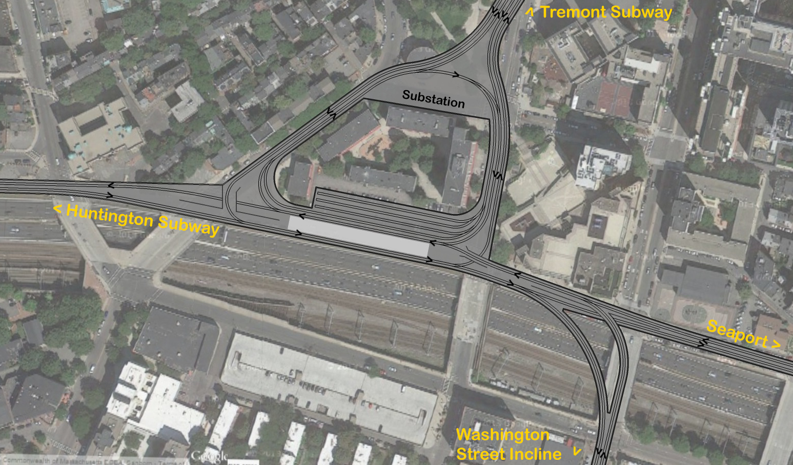
There were mentions of a Bay Village Loop in the Green Line Reconfiguration thread (though some ideas didn't name it as such), which would solve the problem of Huntington-Tremont access. The proposed loop at the intersection of Huntington-Seaport and Park-Nubian trunks would provide connections in several if not all directions depending on design. Each user's design is slightly different, but most of them included at least Huntington-SS-Seaport, Huntington-Tremont-Park, and Nubian-Tremont-Park.

Engineering difficulties aside, that would potentially allow both Huntington-Park-GLX and Huntington-Seaport to become sealed ROWs, and you would probably run some D-E trains on both. Signaling at the loop would be messy but doable without intrusions. That doesn't affect LRT vs HRT but would help with automation.

Here are some images of Bay Village Loop that I can find: davem's initial proposal in Crazy Transit Pitches (2014, probably the first on this idea), George_Apley's map and davem's updated map in early parts of Green Line Reconfiguration thread (2015), and Riverside's map and George_Apley's followup towards the back of the thread (2021). There could have been further discussions somewhere in the middle, but I haven't read through those portions yet.
I've attached davem's initial proposal here. It's the best in illustrating the idea and detailed implementation, but I think the ones in 2021 were probably the most feasible.
12260141186_3e9d2772cc_o.png


Aside: It would be nice if someone can consolidate all the different mainstream Green Line Reconfiguration proposals and evaluations somewhere. Digging through the whole post, while fascinating, is a huge time sink.
 
There were mentions of a Bay Village Loop in the Green Line Reconfiguration thread (though some ideas didn't name it as such), which would solve the problem of Huntington-Tremont access. The proposed loop at the intersection of Huntington-Seaport and Park-Nubian trunks would provide connections in several if not all directions depending on design. Each user's design is slightly different, but most of them included at least Huntington-SS-Seaport, Huntington-Tremont-Park, and Nubian-Tremont-Park.

Yeah, I'm familiar with those proposals. My post's wording was a little ambiguous, but I was mostly asking Riverside for a clarification on something in his post I was replying to that was unclear (specifically whether something he was discussing there connected to Tremont or not).

Engineering difficulties aside, that would potentially allow both Huntington-Park-GLX and Huntington-Seaport to become sealed ROWs, and you would probably run some D-E trains on both. Signaling at the loop would be messy but doable without intrusions. That doesn't affect LRT vs HRT but would help with automation.

Huntington-Boylston would be sealed. No way to avoid traffic mixing on the Park-GC stretch (and beyond), meaning that if you wanted to automate this thing it'd have to at least play nice with the Central Subway signals. (The problem then is that while that's not a huge ask in a future where the subway's signals are properly modernized, with the western branches being a whole different animal it'd be a legitimate question whether it'd be worth the money.)

Seaport wouldn't be sealed without crippling the Silver Line. The SL1 is mode-locked to BRT unless we build another harbor tunnel. (SL3 is as well, but various other proposals have some or all of that service eaten by an LRT Urban Ring, so it's less permanently stuck with the buses.) Sending the SL1 to the surface (and outside fare control to boot) directly cuts against its utility in connecting major transit node (South Station) to major transit node (Logan), and would not be politically feasible. Mixing buses and automated LRVs in a tunnel would have many of the same problems that trying to automate the surface branches would (except with a larger risk of catastrophe if something goes wrong and a Type 10 slams into a bus).

At any rate, while a valid future consideration that may become necessary, automation of the Green Line isn't something immediately needed, and there's a lot more things that can be done to improve the line's capacity and flexibility before we ever have to engage with that particularly thorny issue (which means, as a nice side effect, time for the road interests to do their automation work that could help deal with the surface branch problem without the T needing to be the guinea pigs like they tend to be on equipment design). Future-proofing the new signal system whenever that actually gets done to be able to layer automatic operation on top (at least in the subway/sealed ROWs) would be a good idea, though.
 
@Brattle Loop, yeah, my idle musing assumed no connection to the Tremont Subway at all. It wasn't a serious proposal, and was really just meant to highlight the unlikelihood of being able to create a sealed automated metro line out of the current Green Line infrastructure. Totally agree about LRT being the better fit here.

@Teban54, thanks for digging up those images! Consolidating and summarizing the Green Line Reconfiguration thread is on my to-do list, though it will likely be a few months. I also have my own opinions on the proposals (as you saw -- I go back and forth about the Bay Village Loop, though I think it's a brilliant piece of design either way).
Sending the SL1 to the surface (and outside fare control to boot) directly cuts against its utility in connecting major transit node (South Station) to major transit node (Logan), and would not be politically feasible.

I disagree about taking SL1 out of the Transitway. I think it's well worth consideration. I remembered writing about this in the past, and in fact it was in conversation with you back in June! And apparently the construction at South Station will see better connections between the rail terminal and the bus terminal, which would address one of my major concerns -- degradation of the transfer experience.
 
I disagree about taking SL1 out of the Transitway. I think it's well worth consideration. I remembered writing about this in the past, and in fact it was in conversation with you back in June! And apparently the construction at South Station will see better connections between the rail terminal and the bus terminal, which would address one of my major concerns -- degradation of the transfer experience.

You've got a better memory than I do, I'd entirely forgotten about that discussion!

Referring back to it, if the SL1 can still function acceptably outside the Transitway (I suspect serving the World Trade Center in some capacity is non-optional, especially with the monster Omni now open nearby) and the transfer issue can be addressed acceptably, then I would agree that it would be possible and likely beneficial to take the SL1 out of the Transitway because it doesn't benefit from getting bogged down by serving as both the Airport bus and intra-Seaport transit (especially on the low-capacity buses with luggage racks). I will, however, stand by my view of such a move being politically infeasible if it seriously degrades the transfer experience at South or if it screws up access between the BCEC/hotels and Logan. (I.e., doable if done correctly, problematic if done poorly.)
The other way to deal with the Seaport Hotels versus South Station connectivity is two different SL Airport Lines. SL0 runs express South Station to Logan terminals (via 90, not the transit way). SL1 runs WTC to Logan Terminals. Both clearly designated as Airport service, with luggage racks. SL2 remains the local Seaport connector with higher capacity buses.
 
You've got a better memory than I do, I'd entirely forgotten about that discussion!

Referring back to it, if the SL1 can still function acceptably outside the Transitway (I suspect serving the World Trade Center in some capacity is non-optional, especially with the monster Omni now open nearby) and the transfer issue can be addressed acceptably, then I would agree that it would be possible and likely beneficial to take the SL1 out of the Transitway because it doesn't benefit from getting bogged down by serving as both the Airport bus and intra-Seaport transit (especially on the low-capacity buses with luggage racks). I will, however, stand by my view of such a move being politically infeasible if it seriously degrades the transfer experience at South or if it screws up access between the BCEC/hotels and Logan. (I.e., doable if done correctly, problematic if done poorly.)

Yeah we're basically in agreement -- the devil will be in the details, especially with respect to the transfer. Of course, I also would like to see bus lanes on Summer Street and/or Congress Street, and I think when that happens, it'll be worth re-evaluating sending express buses from Logan via those lanes. Combined with transit priority signaling, it may be faster than the Transitway; in that case, I'd love to see a small surface station constructed at South Station street-level, with or without fare control.

(I like the SL0 designation, although I have to admit it does immediately set itself up to be called the "SL0w bus," ha!)

As for World Trade Center, I actually looked at this over the summer too, and the number of folks boarding an eastbound SL bus in the Seaport or disembarking from a westbound SL bus in the Seaport is tiny. Yes, I agree that could change as conditions in the Seaport evolve. But so far, the Silver Line has not been used significantly for Seaport-Logan travel.

That being said -- the way the off-ramps and on-ramps are situated, a route leveraging surface street bus lanes would almost certainly stop near the World Trade Center anyway, so it could still work.

Of course, the larger and more immediate priorities for the Silver Line definitely should be:
  • better traffic priority at D Street
  • highway access via the State Police Ramp
  • elimination of the wire-diesel changeover (i.e. using battery buses), which eliminates the need for the State Police Ramp, and also would significantly shorten the route between World Trade Center and the Ted Williams Tunnel
  • creation of a transit priority lane in the TWT
 
As for World Trade Center, I actually looked at this over the summer too, and the number of folks boarding an eastbound SL bus in the Seaport or disembarking from a westbound SL bus in the Seaport is tiny. Yes, I agree that could change as conditions in the Seaport evolve. But so far, the Silver Line has not been used significantly for Seaport-Logan travel.

I wasn't even thinking of the actual numbers (though they may well be low enough to get away with) so much as the large interests that would be capable of making a ruckus if their transit connection was removed or diminished (particularly the convention center authority, as well as the hotels), because in political posturing and turf wars facts are annoyingly often optional. BCEC would be annoyed to lose the "direct connection to the airport" marketing line even if very few people actually use it, potentially enough to make a stink.

I agree on the other points, and I would be particularly interested in a Silver Line using Summer Street bus lanes.

  • elimination of the wire-diesel changeover (i.e. using battery buses), which eliminates the need for the State Police Ramp, and also would significantly shorten the route between World Trade Center and the Ted Williams Tunnel

How does getting rid of the wires (would hybrid ETB/BEBs work with the changeover at WTC if BEBs alone weren't quite up to snuff?) eliminate the need for the State Police ramp? Take the right on D then the right down the ramp to the loop onto the Pike into the Ted Williams? (Longer than right on D then to the State Police ramp via the surface, but fewer lights and no left turns.)
 
How does getting rid of the wires (would hybrid ETB/BEBs work with the changeover at WTC if BEBs alone weren't quite up to snuff?) eliminate the need for the State Police ramp? Take the right on D then the right down the ramp to the loop onto the Pike into the Ted Williams? (Longer than right on D then to the State Police ramp via the surface, but fewer lights and no left turns.)

Correct, at least as my thinking. The immediate right turn does make a longer route -- about 3,800 feet vs 2,000 feet from the intersection of D & ramp -- but it potentially could be faster, especially if (hoping against hope) we can get transit lanes on I-90 in the relevant sections.

Fair point about the political/marketing ramifications from the big players in the Seaport -- probably yes, we would need a pair of routes.
 
Another potential ridership driver for WTC to Airport is the MassPort parking garage there at WTC. IIRC Part of the rationale for the construction of that garage was extreme overflow parking for Logan. That has never happened because of the pandemic, but in the future there could be Logan bound drivers parking there and taking the SL service to Logan.
 
If you want to go full crazy transit pitch, could you have a LRT eat SL1?

Basically extend the SL tunnel with a cut and cover through the parking lot near SL way and under congress st, into a new tunnel across the harbor, landing near the ferry terminal. Street run (in dedicated bus/train) lanes through the terminals, somehow ending at the Airport Blue Line station.

The harbor tunnel would obviously not be cheap, but you'd get great transport to Logan, and if this was running down Essex, it'd be a LRT line through the seaport with connections to Orange, Red, and Blue lines with transfers to the rest of the Green Line. It also doesn't accomplish the goal of full automated running since it mixes with traffic at Logan, but it feels more useful to me.
 
Basically extend the SL tunnel with a cut and cover through the parking lot near SL way and under congress st, into a new tunnel across the harbor, landing near the ferry terminal. Street run (in dedicated bus/train) lanes through the terminals, somehow ending at the Airport Blue Line station.

Yeah, the only really crazy part of transforming the SL1 into an LRT line is that it would need a new harbor tunnel. The rest (I might suggest some elevated sections rather than street running even in dedicated lanes, at the airport) is not all that much of a stretch, at least compared to the water crossing. If it had the capability to appropriately serve as an LRT link between what's now the SL3 and the Seaport/Transitway (completing the gap in the northeastern quadrant of the Urban Ring) I think it might potentially be viable (if expensive), though I'm less certain about that as just a pure SL1 replacement.

The harbor tunnel would obviously not be cheap, but you'd get great transport to Logan, and if this was running down Essex, it'd be a LRT line through the seaport with connections to Orange, Red, and Blue lines with transfers to the rest of the Green Line. It also doesn't accomplish the goal of full automated running since it mixes with traffic at Logan, but it feels more useful to me.

It's not quite germane to the main thrust of the post, but tunneling down Essex is dicey at best. Having to underpin Chinatown and Boylston is a big part of what killed Silver Line Phase III fifteen or so years ago, and trying to interface with Boylston without having to underpin it may be physically impossible (if not, it would be very difficult). One of the alternatives preferred by some members here, myself included, is re-using the old Pleasant Street portal lead tunnels (which still exist to about the northeastern corner of Elliot Norton Park on Tremont Street) then digging from there in a longer (but wider and less treacherous) tunnel up some combination of streets to get over to Essex where the insertion point to the Transitway is. Gets the same benefit of connecting Seaport LRT to the HRT lines, but with a one-seat ride through to the Central Subway and transfers to the Green Line's western branches instead of vice-versa. (For far more information on this particular topic, one may refer to the Green Line Reconfiguration thread.)
 
A third Ted Williams tunnel for transit is one of those moonshot items that would be transformative but also incredibly expensive. Of course, if we want to talk really crazy...

Convert one existing TWT bore to two-way auto traffic, and convert the other into a transitway: LRT, BRT, express buses, intercity buses, and perhaps freight trucking. I believe federal regulations would require you to "de-interstate" the transitway bore, as I think LRT is forbidden from interstate highways. You would also need to do some fussing around with ramps at either end. If you utilized the northern westbound bore, you could knock down the wall at World Trade Center station, and hook directly into the Piers Transitway there. And as far as I know, the tunnel is tall enough to support LRT vehicles. It certainly would be a logistical and political challenge.

But the tunnel is there. It's a choice we've made as a society to prioritize its use for private low-occupancy vehicles, and it's a choice we could make as a society to reprioritize it in favor of more ecologically- and economically-beneficial mass transit.
 
But the tunnel is there. It's a choice we've made as a society to prioritize its use for private low-occupancy vehicles, and it's a choice we could make as a society to reprioritize it in favor of more ecologically- and economically-beneficial mass transit.

Oh for a political climate in which this was possible 😞
 
Regarding all the SL1 talks, I thought about moving SL1 to the planned Summer St center-running (was it?) bus lanes if the Transitway was to be used for LRT... Until I realized Summer St doesn't quite replace the current Courthouse and WTC stations. Converting the 7 bus to BRT might be potentially doable, though.

So any proposal of make SL1 surface-running while still coming close to the existing stations will likely make it no longer "real BRT" that the Transitway currently is, or in other words, another SL4/5.

I do think the link between WTC and Logan needs to be preserved, and I do frequently see people from the airport alighting at the surface WTC stop, even though that number is small.

The rest (I might suggest some elevated sections rather than street running even in dedicated lanes, at the airport) is not all that much of a stretch, at least compared to the water crossing. If it had the capability to appropriately serve as an LRT link between what's now the SL3 and the Seaport/Transitway (completing the gap in the northeastern quadrant of the Urban Ring) I think it might potentially be viable (if expensive), though I'm less certain about that as just a pure SL1 replacement.
If you were to go through the trouble of digging a new tunnel anyway, might as well also build a dedicated ROW (either dig through the airport terminals or elevated) just to make it worth it. Depending on implementation, it opens all kinds of potentials here - a centralized Airport Terminals station instead of a stop at each terminal, connecting to BL Airport station and forming UR northeastern quad, an alternative route for commuter rail that offers direct service to Logan and Seaport...

Oh for a political climate in which this was possible 😞
This is when I wish we had the willingness and ability to build subways like those Asian cities. I myself am originally from China and have witnessed all the cities opening new lines like crazy every year.

In that kind of alternate reality, we would have completed RBC, BLX and OLX, started construction of the Huntington-Seaport subway, and figured out a way to somehow make the entire Urban Ring LRT or even HRT with dedicated ROW...

Ok, enough daydreaming for today.
 
Last edited:
So any proposal of make SL1 surface-running while still coming close to the existing stations will likely make it no longer "real BRT" that the Transitway currently is, or in other words, another SL4/5.

I for one don't particularly care about whether it meets any particular standard of "BRT"-ness. If it can run better outside the Transitway rather than in it, that's an improvement. (I'm not taking the position that it necessarily would.)

I do think the link between WTC and Logan needs to be preserved, and I do frequently see people from the airport alighting at the surface WTC stop, even though that number is small.

Makes me wonder if a Summer Street stop is close enough to the WTC to suffice, or if proximity to the BCEC would be enough of a replacement draw. That'd presumably need to be studied.

Depending on implementation, it opens all kinds of potentials here - a centralized Airport Terminals station instead of a stop at each terminal, connecting to BL Airport station and forming UR northeastern quad, an alternative route for commuter rail that offers direct service to Logan and Seaport...

I suppose a central terminal station could work if it was in or under the central parking garage, though Logan's quirky terminal layout unfortunately means there'd likely be some annoyingly-long walks involved. I might do it with two stops, one at the corner where A and B meet and one where C and E meet at what used to be Terminal D, but there'd be a variety of options to choose from to see what fits best. A Blue Line transfer's a no-brainer, it'd help relieve some of the transfer loads downtown from anyone going to the Seaport or anywhere in that direction.

The Commuter Rail idea has been floated around here before. There are arguments both ways on that, and I don't see any need to get back into that argument. I do stand by my position from that discussion that I don't think it'd be the best use of a new harbor crossing compared to RT.
 
I'm continuing my series about extending the Blue Line west beyond Charles/MGH. This week's post discusses possible "first phases" for such an extension, toward Kenmore or toward Kendall.

I have to admit, I struggled a bit with this part of the series. There really are just two options that are thrown around and considered at all realistic; we don't know that much about how they stack up against each other, because they've never been studied and have almost no historical precedent; and while both present excellent benefits, they also each have non-trivial drawbacks, which means that neither one quite feels "brilliant" or "inspired".

I also felt a bit that I was covering the most boring part of the series. The sense I get is that most people perusing this thread have already heard of extending the Blue Line to Kenmore -- usually in tandem with a Blue-to-Riverside extension, which I cover next week. Blue-to-Kendall gets less consistent attention, but once you get past Kendall, there is no consensus on where to go next, or what role the Blue Line should be playing in the network at that point. So I feel there isn't much to say.

Next week's post is where we get to the "fun" stuff -- Blue to Riverside, Blue to Watertown, Blue to Waltham. I'll go into a lot more detail there, which is why I spun this first part off into a separate post. But those "fun parts" need to be built on a foundation, so I guess here we are, eating our vegetables before desert.

I should also say -- transit geology is not something I'm super knowledgeable about. Individuals I respect have walked me through how a subway under Storrow would be feasible, so I feel confident in that proposal (even if I don't feel confident in my ability to explain it). The extensions to Cambridge, I feel much less solid about (no pun intended). Back in the day, F-Line was pretty insistent that tunneling under the Grand Junction was a non-starter, which would impact two of the three Cambridge alignments I discuss in my post. I make a handwaving comment regarding the challenges of working with landfill, but I'm not confident on it to speak authoritatively. However, if Grand Junction alignments are indeed ruled out, then the Cambridge options take a big hit.

Avoiding the Grand Junction by doubling up the Red Line under Main St and Mass Ave sounds like a tunneling nightmare, and I don't think tunneling to the north toward Somerville (e.g. under Hampshire St) fulfills a pressing transit need (my earlier crayon map of the Blue Line taking over GLX notwithstanding). So, if I'm being honest, I do believe that the Kendall option starts off at a disadvantage.

One reason that I chose to sidestep the geology questions is because of where I go in the last two posts in the series after this. I think, when you take a step back and look at the big picture, the Kenmore option wins out without needing to take the geology into account -- ultimately I believe there are more compelling reasons in favor of a Kenmore alignment that render the geology question moot.

Hopefully in time I'll learn enough to feel confident publishing a follow-up piece that gets into these details! But for now, this will have to suffice.
 

Back
Top