Charlie_mta
Senior Member
- Joined
- Jul 15, 2006
- Messages
- 5,200
- Reaction score
- 7,900
This is a great solution. I really like the elevated Gold Line along McGrath, after McGrath Hwy itself has been grounded. Your plan is cost effective (no tunneling needed), politically doable (because McGrath Hwy has been elevated for 65 years, and the new elevated LRV line would be much less obtrusive), and your route connects with both Green Line branches.Prompted in part by the headache I described in the Green Line Reconfiguration thread, I'm spitballing a bit here.
When we’ve talked about putting LRT on the Grand Junction (the “Gold Line” in this post), we usually have figured on connecting it to Sullivan via the Green Line Maintenance Facility (GLMF). This makes sense in a lot of ways, because the yard itself stretches close to halfway from Brickbottom Junction to Sullivan, so the thing’s practically already half built.
However, as I outlined in the Green Line Reconfiguration thread, that alignment creates headaches when trying to plot a northbound course from Cambridge through Brickbottom Junction to the GLMF. It’s somewhat feasible going southbound, but much harder going northbound, requiring either a massive viaduct crossing over the commuter rail maintenance facility, or a tunnel cutting through the heart of the junction.
What does that headache get you? To overstate the point somewhat, the GLMF alignment gets you a one-seat ride from Sullivan to Cambridgeport that manages to miss direct transfers with all three transit lines it crosses (Medford Branch, Union Branch, Red Line). The missed transfer to Red isn’t the end of the world, in part because Kendall is probably more of a destination for this service rather than a transfer node.
But missing the Green Line transfers stings. As close as I can figure, you maybe – maybe – can slot a Medford-Gold transfer near the southwest corner of the GLMF yard, but that would involve shoving a one or possibly two platforms into the spaghetti there (possibly needing to put one of the platforms underground). Such a station would also have almost no walkshed, reducing ROI further on an already costly design.
The primary way we’ve figured on mitigating the missed transfer is by running a Central Subway <> Grand Junction Green Line service via Lechmere. This is workable, but inelegant. North Station <> Kendall is a useful OSR provided by this service, but by definition almost everything else would be faster via a Red Line transfer. And while northside Green Line capacity isn’t as constrained as southside, a Grand Junction branch still means that a hookaround service is taking capacity away from other more efficient radial services.
All of which is to say, a GLMF alignment for the Gold Line isn’t as simple as it first appears, and also has significant drawbacks.
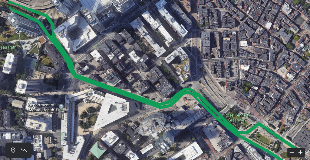
Let’s take a step back and reset: what would the “ideal” route for a northeast Urban Ring be? Obviously you want to hit Sullivan, as well as Kendall. You also want to provide transfers to both branches of the Green Line. Lechmere would be one potential transfer point, but is relatively close to downtown – the other Urban Ring nodes tend to sit closer to 2-3 miles from downtown. The next transfer opportunities would then be at East Somerville and Union Square.
Could we do a Sullivan <> Union <> Kendall LRT route? Sullivan <> Union is at least a straight shot down Washington St, but going Union <> Kendall is much hairier.
But…
Let’s suppose for a minute that we add an infill on the Union Branch between McGrath Highway and Medford St. This would provide a Union-Gold transfer point that is easier to access from Kendall (Grand Junction) than a transfer at Union would be. (Not to say it would be easy, just easier.) I’m gonna call this station “McGrath” for the moment.
So then we need to find a path that goes Sullivan <> East Somerville <> McGrath <> Kendall. And that… that might be doable.
Sullivan <> East Somerville is sorta straightforward. Washington St itself would require a subway or el, but New Washington St just to the south already has a freight rail track running along it, with potentially as few as two grade crossings and enough space between buildings to create a dedicated two-track surface ROW.
From the other direction, Kendall to McGrath Station should be relatively straightforward: tracks rise up from the Grand Junction ROW on to a viaduct that crosses over the Union Branch, putting an elevated platform perpendicular on the northern side of the Green Line above Somerville Ave Extension.
Getting from McGrath Station to East Somerville is hairier, but… well, there already is an elevated structure traversing most of that distance: McGrath Highway itself. If McGrath can be put on a road diet and dropped to surface level, and the elevated decking turned over to LRT, then you can have an el that isn’t any closer to houses/business than the current state.
Then you need to get between the McGrath Highway viaduct and the surface ROW on New Washington. This would require about 1000 feet of a greenfield elevated, either over Washington St proper, or over the adjacent lots (presumably purchased by the Commonwealth), with an elevated station above/above-and-north-of the current East Somerville station.
And… there you go. A Kendall <> Sullivan LRT line that provides transfers to both branches of the Green Line, and which serves actual neighborhoods instead of a no-man’s-land of maintenance facilities.
This alignment is about 1.3 miles, as opposed to the GLMF alignment which is about 1.1 miles. However, the East Somerville alignment would serve more riders, provide better transfers, avoid costly modifications to Brickbottom Junction, avoid operational conflicts with the Green Line, and would do so primarily by using rights-of-way that are already devoted to transportation.
The problems I see:
- Putting McGrath Hwy on a road diet is hardly an original ideabut obviously it's also not a straightforward one, given that we've been talking about it for over 10 years
- And, it should be noted, replacing one elevated structure with another isn't, you know, great
- Grade crossings on New Washington
- Not necessarily a huge problem now, but if/when that area is redeveloped that may change
- Imposing elevated near East Somerville
- See above; if McGrath finally is taken down, blocking out the sky again with another elevated structure is kinda a bummer
- On the other hand, depending on how the el and station are designed, it's possible that this could provide station access to East Somerville significantly more directly than the current station's placement
- Harder to build in stages – harder to use a Lechmere <> Grand Junction branch as a “minimum viable product” as Phase 1
- I think this is still doable, if you just plan to continue running a Lechmere <> Grand Junction branch and drop McGrath Station from the plans; you lose the Gold <> Union transfer, but gain a Green <> Gold transfer somewhere along the Grand Junction branch to the south
Visual:
View attachment 34375
One thought: The grade crossings on New Washington could be eliminated by extending the elevated structure for the Gold Line over those crossings.