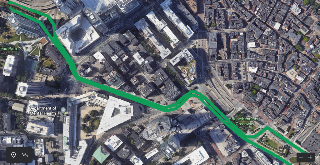
Crazy Transit Pitches

As for a surface LRV line on the RKG, yes, it will impact vehicular traffic, especially at the on/off ramps to the Central Artery, and it would eat one lane in each direction of the surface road as well. But, again, priorities. Is the RKG to be hard-wired for cars only, or can some of that traffic capacity be sacrificed for transit? I would vote for the latter.

I don't particularly care, in the abstract, whether we sacrifice road capacity for transit, but those roads - and particularly those intersections - are a minefield. I don't know how manageable schedule-keeping would be on this thing (especially at peak road traffic times), which isn't necessarily fatal, though it becomes a bigger problem if this is a load-bearing spine meant for service beyond the Greenway.

The surface LRV line would ramp down to the existing busway tunnel in an alignment aimed at the Essex Street loop (at South Station).

The Transitway is under Atlantic running basically northeast-southwest for the block in front of the Federal Reserve. By the time it reaches Congress, it's already turning east to go under Atlantic Wharf and the InterContinental parcel, meaning it's probably impossible to dig down to the outbound/Seaport-bound side of the bus tunnel until you're south of Atlantic. Not impossible, but you'd be chewing up a lot of lanes/sidewalks/green space on that block to fit it, and it'd either have to be two portals bracketing the tunnel or accept a flat junction within the tunnel (eurgh).

Ideally that existing busway tunnel would carry the new LRV line and be extended south and west toward a connection with the Green Line system south of Copley Square or elsewhere as previously discussed on AB

I fail to see what purpose this line would serve. There are basically two classes of connections proposed (not necessarily mutually exclusives) between the Transitway and the existing Green Line; connecting to the existing main trunk as a southern branch via the disused Tremont lead tunnels (i.e. F-Line's Hudson St. routing) or connecting to the western branches (either via a new subway connection via Back Bay with optional junction at the Tremont leads as in some of Riverside's ideas, or a revived SL Phase III routing via Essex/Boylston). I fail to see what advantage is obtained by linking those lines to a surface route with, at best, inferior connections to the Blue and Orange lines and a basically-the-same connection to the Red Line. The capacity gains would be relatively minimal, because the traffic impacts of the surface route mean that they would have to have relatively-low-frequency service with ample padding to avoid completely nuking the rest of the connected network every time something caused the surface traffic to snarl and cause a meltdown. To me, it seems like a lot of headache for very little significant gain.
 
Looking at the layout plans I have of the Central Artery tunnels, there could be space to insert an LRV portal between Congress St and Summer St. The portal would take the surface LRV line running along the RKG, have it dip down into the portal starting at Congress Street, and merge with the Silver Line Tunnel just north of Summer Street, The space for this would be made available by eliminating the NB on-ramp that feeds in from Essex Street. This onramp tunnel goes for a few blocks before finally merging with the NB Central Artery main tunnel. This on-ramp tunnel is about the same elevation as the Silver Line tunnel north of Summer Street.

So, by sacrificing one NB on-ramp, there would be space for a portal to take a surface RKG LRV line into the Silver Line tunnel just north of Summer Street, thus avoiding Dewey Square traffic.
 
So, by sacrificing one NB on-ramp, there would be space for a portal to take a surface RKG LRV line into the Silver Line tunnel just north of Summer Street, thus avoiding Dewey Square traffic.

I don't know how deep the Transitway is at the South Station platforms, but the incline's going to chew up probably several hundred feet on the surface, though I'd imagine there's probably enough running room for an incline from the surface at Congress down to the platform level. But if you run down the Greenway side of Atlantic there, then you'd basically be forcing a flat junction in the tunnel north of the South Station platform, which doesn't seem like the best idea. (Is there even room on the Federal Reserve side to bracket the Transitway with portals/inclines?)
 
I fail to see what purpose this line would serve. There are basically two classes of connections proposed (not necessarily mutually exclusives) between the Transitway and the existing Green Line; connecting to the existing main trunk as a southern branch via the disused Tremont lead tunnels (i.e. F-Line's Hudson St. routing) or connecting to the western branches (either via a new subway connection via Back Bay with optional junction at the Tremont leads as in some of Riverside's ideas, or a revived SL Phase III routing via Essex/Boylston). I fail to see what advantage is obtained by linking those lines to a surface route with, at best, inferior connections to the Blue and Orange lines and a basically-the-same connection to the Red Line. The capacity gains would be relatively minimal, because the traffic impacts of the surface route mean that they would have to have relatively-low-frequency service with ample padding to avoid completely nuking the rest of the connected network every time something caused the surface traffic to snarl and cause a meltdown. To me, it seems like a lot of headache for very little significant gain.
With signal prioritization for the LRV cars and a dedicated reservation for the LRV line, I think it's possible to have a stable schedule for a surface LRV line along the Greenway. The benefits of this would be:
  1. Connection to the Blue Line at State Street Station and obviously the Red Line at South Station., plus within a block of North Station
  2. Alleviate the loading of the GL in Boston's core, from just east of Science Park to beyond Copley Sq, if the LRV is tied through to the GL to the west via a new tunnel through the Mass Pike/South Cove area as discussed elsewhere on AB.
  3. Improved transit access for the central business district, which currently has no transit line close by.
  4. Improved access for tourism and general usage along the Greenway corridor,
  5. A direct transit connection between North Station and South Station, although the access to North Station would require a 1 block walk along Causeway Street (from Merrimac St).
 
With signal prioritization for the LRV cars and a dedicated reservation for the LRV line, I think it's possible to have a stable schedule for a surface LRV line along the Greenway. The benefits of this would be:

I've seen some of those intersections badly gridlocked, albeit pre-pandemic. I'll maintain some skepticism that signal prioritization would be sufficient for dealing with some of those crossings.

  1. Connection to the Blue Line at State Street Station and obviously the Red Line at South Station., plus within a block of North Station

Of course, the existing Green Line has connections to Red and Blue, and in Blue's case, it's a superior connection because it's right downstairs within fare control (Red's basically equivalent.) The existing Orange Line connection is far superior to any surface connection, so those GL cars would have a worse connection.

  1. Alleviate the loading of the GL in Boston's core, from just east of Science Park to beyond Copley Sq, if the LRV is tied through to the GL to the west via a new tunnel through the Mass Pike/South Cove area as discussed elsewhere on AB.

So, a secondary spine/alternate trunk, except even if prioritization works it'll have distinctly lower capacity than the subway. Seems like a relatively high-cost, low-gain option, but a valid goal.

  1. Improved transit access for the central business district, which currently has no transit line close by.

It'd help some, that's true. Not as much as a subway under Congress Street would given that would be more centrally located.

  1. A direct transit connection between North Station and South Station, although the access to North Station would require a 1 block walk along Causeway Street (from Merrimac St).

The thing is, a direct transit connection between those two places isn't all that important, especially if the North Station end is inconveniently located. People who are actually going from North Station or the North Station-touching lines to South Station (or vice-versa) would be better served by improvements to Red and Orange reliability/frequency (and specifically for Amtrak passengers, by Amtrak extending assigned seats to the Regionals to negate the drawbacks of boarding at BBY instead of South.) This isn't the NSRL's network-changing benefits we're talking about.
 
As shown on this Google map, I would connect a a two-track revenue service LRV surface line on the RKG to the existing GL at its portal on Martha Rd. Each track of the new 2-track surface LRV line would straddle the portal to connect to the GL. As I measured it on Google Earth, I think there's enough room to fit in the westbound leg of the new LRV line between the existing WB portal wall and the Expressway ramp. Then the surface LRV 2-track line would continue on a reservation carved out of the overly wide Merrimac St, and tie into the RKG as shown on the map. It would then continue to South Station, ideally dipping down into a portal somewhere north of S Station to tie into the existing Silverline tunnel (in which LRV would continue south and west as discussed on other threads here on AB),
Here's a screenshot of the Google map also, showing the route:

52704025369_cf10879e51_b.jpg
So, I like the attempt to create a second LRV trunk line, and this is not the first time such an idea has been proposed on this board. @Riverside suggested a "Rose Line" that also uses the Greenway, and later on, as a way to connect to the surface Washington St-Nubian branch in a world where a Nubian subway to Park St is built (diverting the "duplicate" surface LRT out of the Green Line system). He also showed "Washington to Greenway" may have greater benefits for CBD commutes, both in travel time and coverage, than "Washignton to Park St".

However:
  • I'm not sure if the Greenway is the best route. My own preference would be the downtown transit corridor that has been proposed for the T7 bus, running from North Station to South Station largely via Pearl-Congress. While this route has less utility for tourists, it significantly enhances connectivity to the Financial District, and has better transfers to the Orange Line. This alignment also allows you to build a subway if you really want to.
  • I don't see much of a need to connect such a surface LRV trunk (regardless of route) to the northside Green Line branches. In any kind of Green Line transformation, northside branches will always have more capacity than southside branches, even with a Chelsea branch included. Instead, a better use of this additional trunk line may be to absorb bus routes such as the T7/93, the T111, etc.
  • To the south, instead of figuring out how to tie it to the Transitway, you can instead run down Summer St, which already has bus lanes in the planning. Then keep the Transitway for other LRT service pattens that interact with subway systems.
The end result of this seems terribly similar to "LRT-ifying T7 and maybe other buses"... But I think it will still have better utility and practicality than as an alternative route for the Green Line.
 
As shown on this Google map, I would connect a a two-track revenue service LRV surface line on the RKG to the existing GL at its portal on Martha Rd. Each track of the new 2-track surface LRV line would straddle the portal to connect to the GL. As I measured it on Google Earth, I think there's enough room to fit in the westbound leg of the new LRV line between the existing WB portal wall and the Expressway ramp. Then the surface LRV 2-track line would continue on a reservation carved out of the overly wide Merrimac St, and tie into the RKG as shown on the map. It would then continue to South Station, ideally dipping down into a portal somewhere north of S Station to tie into the existing Silverline tunnel (in which LRV would continue south and west as discussed on other threads here on AB),
Here's a screenshot of the Google map also, showing the route:

52704025369_cf10879e51_b.jpg
Some bigger picture comment below, but I want to briefly highlight how this route indirectly highlights the difficulties of surface transit accessing North Station. Whether LRT or BRT, it's not as straightforward to get to North Station's front door as it at first seems. I think I drew up a sketch of some modifications to Canal and Friend Streets, which were a bit kludgey but also the best I could come up with. (And that was why my "Washington-to-Waterfront" LRT Line terminated at Haymarket rather than dealing with getting to North Station.)

A few comments in no particular order:

In general, I am not inclined to interline new downtown surface routes with the Green Line proper. A parallel surface LRT network (or one using a new subway) has more potential, but introducing additional variability to the Green Line doesn't seem useful.

Also in general, I think a Greenway trolley is less viable than it appears on a map. One of the reasons I've felt my "Rose Line" proposal could work was because it explicitly targets an audience where slow travel is less of a drawback (compared to convenience). But for commuting/general travel purposes, I think it presents a lot of downsides. (And @Brattle Loop to your point about crossing Dewey Square, in my latest sketches, I just have the Rose Line terminate at a loop around the Federal Reserve building, coming down Congress, turning on to Dorchester, stopping on Summer across from South Station, and turning back north on Atlantic -- avoiding Dewey as much as possible).
So, I like the attempt to create a second LRV trunk line, and this is not the first time such an idea has been proposed on this board. @Riverside suggested a "Rose Line" that also uses the Greenway, and later on, as a way to connect to the surface Washington St-Nubian branch in a world where a Nubian subway to Park St is built (diverting the "duplicate" surface LRT out of the Green Line system). He also showed "Washington to Greenway" may have greater benefits for CBD commutes, both in travel time and coverage, than "Washignton to Park St".
I probably should amend my posts about "Washington to Greenway" to clarify that I consider them to be more exploratory rather than an out-and-out "proposal", to be clear. (And, FWIW, on my current sketches, I just said screw it, and have a F Line to Nubian via Washington and a G Line to Nubian via BUMC -- it's just not worth the trouble.) Though yes, I do stand by my analysis insofar as "landing" a radial service near South Station rather than Park Street has underestimated benefits.
However:
  • I'm not sure if the Greenway is the best route. My own preference would be the downtown transit corridor that has been proposed for the T7 bus, running from North Station to South Station largely via Pearl-Congress. While this route has less utility for tourists, it significantly enhances connectivity to the Financial District, and has better transfers to the Orange Line. This alignment also allows you to build a subway if you really want to.
  • I don't see much of a need to connect such a surface LRV trunk (regardless of route) to the northside Green Line branches. In any kind of Green Line transformation, northside branches will always have more capacity than southside branches, even with a Chelsea branch included. Instead, a better use of this additional trunk line may be to absorb bus routes such as the T7/93, the T111, etc.
  • To the south, instead of figuring out how to tie it to the Transitway, you can instead run down Summer St, which already has bus lanes in the planning. Then keep the Transitway for other LRT service pattens that interact with subway systems.
I agree with all of this. Regardless of mode -- whether surface BRT, surface LRT, subway LRT, or subway HRT -- I think the strongest candidate for a new corridor through downtown is along Congress St. (And yes, all the more so because you could eventually replace a surface corridor with a subway.)

I don't see a good way to connect a northside service into the Transitway, unless you are willing to sacrifice a connection to South Station altogether. I think Summer St is much more effective.
The end result of this seems terribly similar to "LRT-ifying T7 and maybe other buses"... But I think it will still have better utility and practicality than as an alternative route for the Green Line.
On a grand time scale, yes, I think LRT'ing the T7 and similar routes is the predictable endgame of the process underway right now. The T7, the T111, and SL4/5 are the last few corridors where a surface transit route should run into downtown as a one-seat journey. (I also argue for some service from Everett, though I know that's highly debatable. One could also mayyyyybe be argue that a re-extended 55 belongs in this club.) Building a proper BRT core along Congress St will make a big difference for the T7 and will I think significantly change the conversation; with successful BRT in place, it will hopefully seem more justifiable to invest in creating a small set of modern streetcar lines to cover that network. (It's fun to imagine a small "subway streetcar" network running through a Congress St Subway, fanning out to Washington St, Summer St, Charlestown, Chelsea, and Everett. <--- There's your Crazy Transit Pitch.)
 
(It's fun to imagine a small "subway streetcar" network running through a Congress St Subway, fanning out to Washington St, Summer St, Charlestown, Chelsea, and Everett. <--- There's your Crazy Transit Pitch.)

It's a pity we already have the Orange Line, otherwise we could keep the Central Subway routes as Green, and bring back traction orange for the streetcar ones running to Congress. I'd like to see an orange and cream Type 10 (mmm...creamsicles...)
 
Inspired by learning about how Toronto is planning to serve its version of the Seaport with mass transit and stuck in an interminable-yet-irrelevant all-company Zoom this afternoon, I wondered...what would a strategy like that look like in Boston? Consider this yet another iteration of putting lipstick on the misbegotten Silver Line.

The scenario I'm working off of:
  1. A political decision is made that connecting the transitway to anything west of South Station is a fool's errand due to cost of tunneling via Essex or another route.
  2. Other transit projects (regional rail, BLX, maybe something complicated having to do with the Central Subway -- the eagle-eyed among you may catch a few things in the screenshot, below) take too much money and/or oxygen out of the room but, as seems to happen depressingly often, buses offer insufficient ribbon-cutting opportunities. Or maybe their per-passenger operating costs get hard. Either way, an imperative to find relatively cheap solutions to boost capacity.
Cue: Judy Garland singing

Lights up. Enter, stage left: Glorified trolleys

Back to the future babyyyyyy 😎

Screenshot 2023-03-01 194133.png


Routes (all surface-running, in dedicated, cheap-as-can-be, Columbus Ave.-style transit lanes as much as possible):
  • South Station > Design Center via Transitway (1.82 miles)
  • South Station > Andrew via Transitway, new tracks cut between Haul Road and Summer Street over Massport and federally-owned land, Broadway and Dorchester Street (3.3 miles)
  • City Point > Back Bay via Broadway, then Traveler Street Bridge, Herald Street, and a one-way loop stretching to Dartmouth (3.89 miles)
  • Andrew > Columbia Point via Old Colony Ave underpass and JFK (1.79 miles)
Key bits of building:
  • Stops are spaced every third of a mile, roughly. A bit close, but this is intended to offer feeder service, not main-line transit.
  • New bridge on the upstream side of the Reserved Channel so Conley Terminal trucks and tram tracks don't mingle and Massport can be bought off.
  • Limited train storage on the Design Center lots
  • Train storage on that builder's yard (eminent domaine'd) at East 1st and Farragut.
  • OMF and main yard on the UMass Boston lot across University Drive from the EMK Institute, presumably built-for-but-not-with a UMass Boston air-rights to replace whatever they had in mind for that lot.
    • (I eyeballed these two major depots vs. various TTC and MBTA Green Line facilities and back-of-the-napkin math says there'd be enough room to store 80 or more Type 10 trains to serve this system)
Needs this serves:
  • Adds capacity to over-stressed SL1, #7 and #9 buses, especially with the Edison Plant area set to keep growing, eats up lanes on the Southie drag strip Broadway and maybe helps Five-Car Flaherty go down to one car.
  • Adds some crosstown capacity, albeit without addressing perhaps the most important piece of southside cross-town capacity between Nubian and Longwood.
    • That said, could some of this infrastructure enable another crosstown line via Mass. Ave., Melnea Cass etc.?
  • Improves transit access for all the new folks moving into what's currently the McCormack housing project as WinnCompanies and the BHA add gobs more density.
  • Similarly, improves access for Dorchester Bay City, Harbor Point and UMass Boston.
    • But honestly, that spur is chiefly there to access what seems like one of the only realistic OMF sites in this part of town -- feels too hard to marry a marine industrial use with an OMF or train storage to get the BPDA/EIDC to accept one in the Flynn Marine Park area, and it'd be better to use land already off the tax rolls than try to scoop up something in Newmarket.
 
Last edited:
Inspired by learning about how Toronto is planning to serve its version of the Seaport with mass transit and stuck in an interminable-yet-irrelevant all-company Zoom this afternoon, I wondered...what would a strategy like that look like in Boston? Consider this yet another iteration of putting lipstick on the misbegotten Silver Line.

The scenario I'm working off of:
  1. A political decision is made that connecting the transitway to anything west of South Station is a fool's errand due to cost of tunneling via Essex or another route.
  2. Other transit projects (regional rail, BLX, maybe something complicated having to do with the Central Subway -- the eagle-eyed among you may catch a few things in the screenshot, below) take too much money and/or oxygen out of the room but, as seems to happen depressingly often, buses offer insufficient ribbon-cutting opportunities. Or maybe their per-passenger operating costs get hard. Either way, an imperative to find relatively cheap solutions to boost capacity.
Cue: Judy Garland singing

Lights up. Enter, stage left: Glorified trolleys

Back to the future babyyyyyy 😎

View attachment 34840

Routes (all surface-running, in dedicated, cheap-as-can-be, Columbus Ave.-style transit lanes as much as possible):
  • South Station > Design Center via Transitway (1.82 miles)
  • South Station > Andrew via Transitway, new tracks cut between Haul Road and Summer Street over Massport and federally-owned land, Broadway and Dorchester Street (3.3 miles)
  • City Point > Back Bay via Broadway, then Traveler Street Bridge, Herald Street, and a one-way loop stretching to Dartmouth (3.89 miles)
  • Andrew > Columbia Point via Old Colony Ave underpass and JFK (1.79 miles)
Key bits of building:
  • Stops are spaced every third of a mile, roughly. A bit close, but this is intended to offer feeder service, not main-line transit.
  • New bridge on the upstream side of the Reserved Channel so Conley Terminal trucks and tram tracks don't mingle and Massport can be bought off.
  • Limited train storage on the Design Center lots
  • Train storage on that builder's yard (eminent domaine'd) at East 1st and Farragut.
  • OMF and main yard on the UMass Boston lot across University Drive from the EMK Institute, presumably built-for-but-not-with a UMass Boston air-rights to replace whatever they had in mind for that lot.
    • (I eyeballed these two major depots vs. various TTC and MBTA Green Line facilities and back-of-the-napkin math says there'd be enough room to store 80 or more Type 10 trains to serve this system)
Needs this serves:
  • Adds capacity to over-stressed SL1, #7 and #9 buses, especially with the Edison Plant area set to keep growing, eats up lanes on the Southie drag strip Broadway and maybe helps Five-Car Flaherty go down to one car.
  • Adds some crosstown capacity, albeit without addressing perhaps the most important piece of southside cross-town capacity between Nubian and Longwood.
    • That said, could some of this infrastructure enable another crosstown line via Mass. Ave., Melnea Cass etc.?
  • Improves transit access for all the new folks moving into what's currently the McCormack housing project as WinnCompanies and the BHA add gobs more density.
  • Similarly, improves access for Dorchester Bay City, Harbor Point and UMass Boston.
    • But honestly, that spur is chiefly there to access what seems like one of the only realistic OMF sites in this part of town -- feels too hard to marry a marine industrial use with an OMF or train storage to get the BPDA/EIDC to accept one in the Flynn Marine Park area, and it'd be better to use land already off the tax rolls than try to scoop up something in Newmarket.
I love it! It’d be interesting to do a cost comparison between this and a back bay-south station green line.

You might as well have one trolley line enter the pleasant st portal and turn at the Park st loop, like the old days
 
I really like this plan just because I know how ridiculous the crowding on Southie buses is during rush hour right now. Both Broadways and Dorchester St. have more than enough room for light rail, and it would be a huge boon to the neighborhood.
 
Any other projects in North America (or Western Europe, though we know those costs often are not apples to apples) that are building/have recently built modern elevateds?
Sections of the recently opened K Line in Los Angeles are elevated, but I don't know whether there is cost data that breaks out the viaduct construction compared to the street level. There is even a subway section, so untangling it all might be tricky.
 
A new crazy transit pitch: Route the Silverline bus line in the South End into the abandoned Tremont Street tunnel. When the busses arrive at Boylston Station, have the bus lane loop around and cross the GL tracks at the north end of the station. Then the GL tracks can expand to 4 tracks immediately north of this bus loop. Routing the Silverline bus line into the abandoned Tremont St tunnel will eliminate a major congestion point on surface streets for the Silverline, plus provide a direct cross-platform transfer from the busses to the GL at Boylston Station..
 
A new crazy transit pitch: Route the Silverline bus line in the South End into the abandoned Tremont Street tunnel. When the busses arrive at Boylston Station, have the bus lane loop around and cross the GL tracks at the north end of the station. Then the GL tracks can expand to 4 tracks immediately north of this bus loop. Routing the Silverline bus line into the abandoned Tremont St tunnel will eliminate a major congestion point on surface streets for the Silverline, plus provide a direct cross-platform transfer from the busses to the GL at Boylston Station..
The Tremont Street tunnel is much too small for the clearances required by buses, IIRC.
 
I thought that was the original Flynn-era proposal to sandbag any future LRT conversion.
 
A new crazy transit pitch: Route the Silverline bus line in the South End into the abandoned Tremont Street tunnel. When the busses arrive at Boylston Station, have the bus lane loop around and cross the GL tracks at the north end of the station. Then the GL tracks can expand to 4 tracks immediately north of this bus loop. Routing the Silverline bus line into the abandoned Tremont St tunnel will eliminate a major congestion point on surface streets for the Silverline, plus provide a direct cross-platform transfer from the busses to the GL at Boylston Station..
If you're willing to do that, then why not just convert the entire branch to LRT?
 
The Tremont Street tunnel is much too small for the clearances required by buses, IIRC.
Is that true even if the buses are on a guideway system to keep them aligned in the tunnel to address the narrow horizontal clearance? The vertical clearance is adequate already, I would think, as the tunnel was designed for trolley cars with catenary poles above.
 
When the busses arrive at Boylston Station, have the bus lane loop around and cross the GL tracks at the north end of the station.

Boylston's geometry makes that prospect difficult. The merge from track 3 to track 4 (eastbound fence and wall tracks) is midway along the outbound platform. You'd either have to somehow share space on Track 4 between the LRVs and the buses, or cross the buses over from 4 to 3 (which isn't super-useful in regular service without any service pattern terminating at the Park loop). Doing that, though, means it'd be a sharper curve to cross Track 2 at the north end of the outbound platform, and it'd mean two separate places where the SL would be crossing the active GL tracks (even assuming the tunnel can be modified to permit it, there's a lot of columns in there).

That said, I'd wager a guess that any crossing of the GL is where this idea would go to die. Green does not currently have, and Silver does not have any prospect (that I know of) of having any kind of positive stop system. Interacting bus traffic with the GL surface branches (which have mainly perpendicular crossings) is unavoidable, but deliberately building in a traffic-crossing loop in a tunnel seems a step too far. All it would take would be for one GL or SL operator to pass a red signal, and then you could have an LRV t-boning a SL bus. They already have enough problems keeping the trolleys from hitting each other, deliberately adding the much-weaker SL vehicles seems like a recipe for absolute disaster. (It's less of a risk, though not non-existent, in any of the shared LRT/BRT tunnel ideas, because it's safer if everything's flowing in the same direction rather than having crossing traffic.)
I hear you about the safety risk, and thank you for the thorough analysis. I was thinking BRT in the tunnel to Boylston Sta as an interim measure, which would at least accomplish refurbishing the tunnel and building a portal in South Cove so it would be ready for future LRV conversion. The safety issues of the bus turnaround that would be needed at Boylston Sta, plus all the cost of rehabbing the tunnel and building the portal for BRT, makes the extra investment needed for immediate LRV conversion all the way to Nubian more appealing.
 

Back
Top