You are using an out of date browser. It may not display this or other websites correctly.
You should upgrade or use an alternative browser.
You should upgrade or use an alternative browser.
Crazy Transit Pitches
- Thread starter BostonUrbEx
- Start date
F-Line to Dudley
Superstar
- Joined
- Nov 2, 2010
- Messages
- 10,021
- Reaction score
- 12,549
The plan, back from the "Indigo Line" proposal, was to move the Readville platform off the Fairmount-Franklin connector north about 500 ft. with a south tip aligned with the Hyde Park Ave./Milton St./driveway intersection. Then drop an island platform in the gap between the current mainline track and the freight lead. They'd then re-interlock the tracks north and south of the platform so both sides of the platform are accessible from any train and also to/from either the Franklin or NEC connectors (the NEC connector does exist and is used by the last Stoughton revenue train of the night). Then add a third-track turnout at the south interlocking so the backing-up freight trains miss the platform (Franklin Line to the Readville backup is a protected high-and-wide freight clearance route).I would say ~7 min frequencies. They would be mainline EMUs, but obviously shorter than full electric CR trains. The insides would also be somewhat modified with fewer, if any, longitudinal seating, for example, since most journeys would not be longer than ~15 mins. The main engineering challenges would be:
- Adding a couple platforms at South Station exclusively for Fairmount Line use
- Electrifying the line
- Adding a new maintenance facility and yard. Given that Widett Circle is about to be leveled, I'm not particularly concerned about the logistics here.
- Rebuilding Readville Station with two full-high platforms
- A track connection to allow for service to continue and terminate at a modified/rebuilt Rte 128/University Park (Optional)
Chances are you would not thru-route Fairmount trains to Route 128 Station. That involves re-invoking the Amtrak dispatcher at TRANSFER Interlocking at the NEC hook-in, which is going to cause hiccups in the regular Fairmount headway when there's an Amtrak-priority slot. You'd be better off extending to Dedham Corporate Center (where there's room for a pocket turnback track) as that stays entirely under the MBTA dispatcher.
The only freight inbound of Readville Yard was a nocturnal switch of the cold storage warehouse at Widett Circle, done on the 1:00am-5:00am shift. That customer has been idle for 2-3 years, and they were only getting weekly deliveries when they were using rail. So right now there's nothing whatsoever. Should Marine Terminal get its Massport rail spur off Track 61, the extant Readville-Widett slot would simply go 6 nights a week and be extended to Southie. It's understood that because of crossing Southampton Yard and the Old Colony main at-grade that CSX would never be able to do a daytime freight there, and it says so in Massport's feasibility study about the Marine T. spur.Is the volume of freight traffic large enough that restricted hours would be a major problem? I know there is some, an in addition to Amtrak being very unhappy that means full subway conversion isn't happening, but I don't think it's enough that night operations would be insufficient.
But if someone has some numbers, or at the very least anecdotes, on freight traffic on the line that would be appreciated.
The Readville yard-stocker round trip out of Framingham-Walpole runs on the midday off-peak, and that's the one that inches past the current Readville platform on its back-up move in/out of the yard and on/off the Franklin-Fairmount connector. This job is a big reason why the Readville platform needs to move north beyond the turnout switch, so one platform is never blocked by a slowly backing-up freight train.
Teban54
Senior Member
- Joined
- Nov 13, 2021
- Messages
- 1,142
- Reaction score
- 2,856
Great analysis. First, a few minor points:Alright, so here's stop-by-stop boardings and alightings for Northbound passengers along the entire route of the 15, 23, and 28, the main buses that bring passengers from Dorchester/Mattapan/Roxbury etc into Nubian (And then Ruggles.)
- Which dataset did you use that doesn't have Nubian and Ruggles for 15 and 23? The one I used (grouped by time periods of the day, mentioned upthread) has both Nubian and Ruggles for both routes.
- Your data for the 28 at Nubian and Ruggles, individually, also seem way too low. (The Bus Route Profile has 1,640 and 1,500 alightings per weekday respectively, not per week.)
- I also don't think people going between local stations near the Fairmount Line will take it for 1-2 stops in place of buses (especially the 28). Buses are much more direct for short-haul trips like this. (Most intermediate stops on Fairmount are also surrounded by residential neighborhoods, but I'd think most people are not going between houses, but rather, from their houses to restaurants, supermarkets, etc.) Of course, that doesn't affect the discussion of a Nubian "subway".
- I'm pretty sure the core Green Line system can't handle 3-car Type 10s. Boylston itself is a huge limiting factor, as its platform length may not even handle 2-car trains without moving fare gates, and the platforms can't be extended in either direction. There are old posts on this forum about it, but I can't find them now.
Capacity and Frequency: Is LRT alone enough?
For simplicity, let's assume the Nubian-Washington-downtown LRT has 1.5-2x as much ridership as each individual GL branch. (Questionable for the B branch, but I think there's a general consensus that the B is underserved.)
Here are the trips per hour for AM peak (7-9am) on a few routes:
TransitMatters has data for historical Green Line arrival times and headways, though I haven't looked into them yet.
MBTA also has datasets with average headways between stations. The filter I linked here shows that in Fall 2019, average headways on branches from Park to Boylston during weekday peak to be: 400.66, 473.73, 397.65 and 392.68 seconds (B/C/D/E). This means in an hour, there are 8.99 B trains, 7.60 C trains, 9.05 D trains and 9.17 E trains, for a combined 34.8 tph.
Eastbound data turns out to be cleaner - 102.58s headways, which is 35.09 tph.
Beginning October 24, 2021, B and C terminated at Government Center, while D and E terminated at North Station (extended later). Service was probably at reasonably high levels until a service reduction in Fall 2022.
So I played around with the big headache of 2022 headways data. On the 20 weekdays during the first 4 weeks in January 2022, during 7:30am-9:30am, from Park St to Government Center:
GC -> Park during the same time frame has a bit cleaner data:
So while there's no immediate evidence for 40 tph or even 35 tph, I think 30 tph for Park-GC should be very doable. I also don't see how that section may have a worse limit than sections like Boylston-Arlington, which is even more curvy. I suspect some of the limitations of GC-Park may be for southbound trains to be sorted into the correct platform, but that won't be a concern in a GLR world.
FWIW, current schedules suggest 8-min AM peak frequencies on the B or 7.5 tph, even with slow zones and a possibly reduced fleet. The E seems to have about 8-min during peak as well. So doing an analysis on present-day data may net more interesting results, but I don't want to do that just yet after already looking at the 2022 data.
So I played around with the big headache of 2022 headways data. On the 20 weekdays during the first 4 weeks in January 2022, during 7:30am-9:30am, from Park St to Government Center:
- B branch: Avg headway 124.33s (based on the "headway" data in the spreadsheet), 7.075 trains (based on number of trains reported)
- C branch: Avg headway 138.44s, 7.00 tph
- D branch: Avg headway 125.57s, 7.05 tph
- E branch: Avg headway 124.91s, 6.30 tph
GC -> Park during the same time frame has a bit cleaner data:
- B branch: Avg headway 516.75s, 6.85 tph
- C branch: Avg headway 510.65s, 6.90 tph
- D branch: Avg headway 538.14s, 6.725 tph
- E branch: Avg headway 566.02s, 6.15 tph
So while there's no immediate evidence for 40 tph or even 35 tph, I think 30 tph for Park-GC should be very doable. I also don't see how that section may have a worse limit than sections like Boylston-Arlington, which is even more curvy. I suspect some of the limitations of GC-Park may be for southbound trains to be sorted into the correct platform, but that won't be a concern in a GLR world.
FWIW, current schedules suggest 8-min AM peak frequencies on the B or 7.5 tph, even with slow zones and a possibly reduced fleet. The E seems to have about 8-min during peak as well. So doing an analysis on present-day data may net more interesting results, but I don't want to do that just yet after already looking at the 2022 data.
And that's with the current demand for SL4/5 at Nubian. While some of them (especially from the 15 bus) will be diverted to Fairmount, there's also the potential to absorb a significant number of riders who currently transfer at Ruggles (plus induced demand from neighborhoods along the route due to more convenient downtown transfers), so I think the two effects will at least break even (inconclusive of course).
So there's a real argument that an alternative Nubian service is needed not just for speed, but for capacity and to not let Washington St streetcar become a service decrease, though more analysis is needed. (While we're on this topic, I wonder if GLX is also underserving Somerville given the density.)
Last edited:
Teban54
Senior Member
- Joined
- Nov 13, 2021
- Messages
- 1,142
- Reaction score
- 2,856
Benefits to the rest of the (reconfigured) Green Line network
I realized I never really explained this point in detail, so let me do that.
The Green Line Reconfiguration proposals involve reverse-branching from Huntington: (For illustration only, not showing accurate Bay Village engineering like this, this and this)

Any trains to Copley and Kenmore will terminate at Park via the inner loop, being isolated from the system above. (I use "Lime" for the Kenmore division, and use "Green" to refer solely to the Park-Huntington route above.)
Both the Green and Magenta routes are obviously highly desirable. In fact, I think Magenta may have even higher demand than Green: It connects Seaport, South Station, Back Bay and LMA, all of which are absolutely huge. I'd say both deserve 3-min headways or 20 tph.
However, their combined capacity is limited by the Huntington trunk (40 tph in this scenario). Running frequent service on Magenta means you lose service on Green, from Bay Village (which itself borders parts of South End with good density) to Park to Government Center, and likely towards North Station. (GC-NS is currently limited to 2 branches, but there's argument that it deserves more.) If you want this stretch to run maximum capacity, you'll need more trains on the Brown route - ideally as many trains as Magenta (20 tph / 3 min).
The problem is, I very much doubt that a Washington St surface streetcar can reliably support <5 min headways, much less 3 min. Frequent bunching and delays will likely be issues if you run it at 3-min headways (which has never been done on any GL branch today), which will also affect reliability of Green, because there's no way to isolate Brown (that feeds into Boylston's outer tracks) from Green unlike Lime can. Delays on Green will eventually also affect Magenta.
Running the Washington St streetcar and the I-93 grade-separated route both at 6-min headways greatly alleviates the problem. It also reduces dwell times on Washington St if most/all riders from Nubian are not using it, further improving its reliability.
So yeah, this is much more than whether Nubian riders deserve an 8-min ride to downtown or a 14-min one, or whether a streetcar branch can handle the load. It has much greater benefits to the entire GL Reconfiguration network. And if my idea of running an "El" over I-93 and Melnea Cass can work, you only need about 2,000 ft of tunneling under Herald St, most of which can be done with C&C.
I realized I never really explained this point in detail, so let me do that.
The Green Line Reconfiguration proposals involve reverse-branching from Huntington: (For illustration only, not showing accurate Bay Village engineering like this, this and this)
Any trains to Copley and Kenmore will terminate at Park via the inner loop, being isolated from the system above. (I use "Lime" for the Kenmore division, and use "Green" to refer solely to the Park-Huntington route above.)
Both the Green and Magenta routes are obviously highly desirable. In fact, I think Magenta may have even higher demand than Green: It connects Seaport, South Station, Back Bay and LMA, all of which are absolutely huge. I'd say both deserve 3-min headways or 20 tph.
However, their combined capacity is limited by the Huntington trunk (40 tph in this scenario). Running frequent service on Magenta means you lose service on Green, from Bay Village (which itself borders parts of South End with good density) to Park to Government Center, and likely towards North Station. (GC-NS is currently limited to 2 branches, but there's argument that it deserves more.) If you want this stretch to run maximum capacity, you'll need more trains on the Brown route - ideally as many trains as Magenta (20 tph / 3 min).
The problem is, I very much doubt that a Washington St surface streetcar can reliably support <5 min headways, much less 3 min. Frequent bunching and delays will likely be issues if you run it at 3-min headways (which has never been done on any GL branch today), which will also affect reliability of Green, because there's no way to isolate Brown (that feeds into Boylston's outer tracks) from Green unlike Lime can. Delays on Green will eventually also affect Magenta.
Running the Washington St streetcar and the I-93 grade-separated route both at 6-min headways greatly alleviates the problem. It also reduces dwell times on Washington St if most/all riders from Nubian are not using it, further improving its reliability.
So yeah, this is much more than whether Nubian riders deserve an 8-min ride to downtown or a 14-min one, or whether a streetcar branch can handle the load. It has much greater benefits to the entire GL Reconfiguration network. And if my idea of running an "El" over I-93 and Melnea Cass can work, you only need about 2,000 ft of tunneling under Herald St, most of which can be done with C&C.
Teban54
Senior Member
- Joined
- Nov 13, 2021
- Messages
- 1,142
- Reaction score
- 2,856
Improving service on Warren St
This is an interesting and very relevant thought, which I've also briefly considered before. Indeed, if we use Delvin's map as a rough measure of density:

While there's good residential density (and job density?) around Nubian, Warren St is arguably even denser. And it nicely fills the gap between Orange and Fairmount, effectively covering most of the area with their walksheds. Even nicer if we can run it to Franklin Park (a recreational destination itself) and/or connect to Fairmount at Four Corners/Geneva.
The biggest concern I have is - again - reliability of surface running:

(If we build all of this, Washington streetcar and I-93 subway, I think it's worth looking at letting the I-93 service serve the surface section south of Nubian rather than the streetcar. In addition to avoiding a B branch 2.0, this also improves travel times for points south of Nubian, and lets you dig a tunnel through Nubian onto a portal on Warren St that bypasses several big intersections around Nubian. This point may be more for @Riverside.)
This is an interesting and very relevant thought, which I've also briefly considered before. Indeed, if we use Delvin's map as a rough measure of density:
While there's good residential density (and job density?) around Nubian, Warren St is arguably even denser. And it nicely fills the gap between Orange and Fairmount, effectively covering most of the area with their walksheds. Even nicer if we can run it to Franklin Park (a recreational destination itself) and/or connect to Fairmount at Four Corners/Geneva.
The biggest concern I have is - again - reliability of surface running:
- Pleasant St incline (Eliot Norton Park, typically considered as the portal location for Washington St streetcar) to Nubian is 1.8 miles, shorter than the C branch (2.2) and similar to the E branch (1.6).
- Pleasant St incline to Grove Hall (Warren St / Blue Hill Ave) is 3.4 miles.
- Pleasant St incline to Franklin Park is 3.8 miles, almost as long as the B branch (4.0), whose reliability is infamously bad.
- This is also why any LRT proposal that through-runs from Park all the way to Mattapan simply won't fly.
- Terminate the line at MLK Blvd (not ideal for catchment)
- Dig a short, 0.5-mile tunnel that bypasses this narrow section of Warren St ($$)
- Run in mixed traffic (lower reliability, not sure if traffic is decent enough)
- Or, this interesting idea that takes 1 lane each on Warren St, BHA and Quincy St: (some deviations from typical route, and may either still run in mixed traffic or turn these streets into one-way)
(If we build all of this, Washington streetcar and I-93 subway, I think it's worth looking at letting the I-93 service serve the surface section south of Nubian rather than the streetcar. In addition to avoiding a B branch 2.0, this also improves travel times for points south of Nubian, and lets you dig a tunnel through Nubian onto a portal on Warren St that bypasses several big intersections around Nubian. This point may be more for @Riverside.)
TheRatmeister
Senior Member
- Joined
- Sep 23, 2023
- Messages
- 1,584
- Reaction score
- 3,212
That still leaves the (Admittedly not great) option of just, not stopping at Boylston, but this could create problems with overcrowding Park St.I'm pretty sure the core Green Line system can't handle 3-car Type 10s. Boylston itself is a huge limiting factor, as its platform length may not even handle 2-car trains without moving fare gates, and the platforms can't be extended in either direction. There are old posts on this forum about it, but I can't find them now.
I'm not sure 5 min headways are actually unworkable. Some quick digging turned up this paper which mentions bunching on the Silver Line, pointing out that the biggest problems for reliability are:The problem is, I very much doubt that a Washington St surface streetcar can reliably support <5 min headways, much less 3 min. Frequent bunching and delays will likely be issues if you run it at 3-min headways (which has never been done on any GL branch today), which will also affect reliability of Green, because there's no way to isolate Brown (that feeds into Boylston's outer tracks) from Green unlike Lime can. Delays on Green will eventually also affect Magenta.
- Long boarding times, exacerbated at the time of study by the new fare system. This could be improved with off-board fare collection and by using vehicles with more doors. You can even do this with buses, 4 door articulated buses are a thing that exist. (Although these are slightly longer)
- Because Temple Place is constrained, it doesn't really act like a terminus. The line therefore operates like it's twice as long, with buses having to correct for deviations in headways from both the inbound and outbound trips at Nubian. This would be alleviated by having a proper downtown terminus.
- The biggest factor according to the study, regulation of headways at Nubian is (Or at least was)... crap, to put it bluntly. Not necessarily because it needs to be, but just from poor operations and operations management. The solution here is pretty self-explanatory.
With all of these problems addressed, I don't think 5 min headways are impossible.
So: total capacity. From what I can find, an articulated bus (À la Silver Line) can carry about 120 people max. Assuming 3 min headways, that means that the Silver Line can carry around 2400 people per direction per hour. A single Type 9 car can hold 212 passengers, and with 5 minute headways you're already at 2500 people per direction per hour, despite the worse headways. And that's just a single Type 9. If we use a single type 10 instead, we can double that to 5000 people per hour. And then with a double type 10 you'd be able to push 10,000 people per hour. Ridership could quadruple from current Silver Line ridership, and it would still be fine, even without triple Type-10s.
The main issue then turns to the central subway. There are two main problem points: The Pleasant St Portal, and Park St Station. Let's start with the former:
The question for the Pleasant St Portal (And tail end of the Tremont St Subway) is if the ~1100ft shared section with the Lime routes would lead to significant delay contagion and operational headaches. I don't think it would, but this is not an expert opinion. Either way, if things did completely break down on this section for whatever reason there is still the option of running those trains to South Station and Seaport instead.
I would argue that Park St is actually the biggest problem. Splitting 4 platforms between 5 branches is not super easy to do. We'll presumably want two branches to continue on to GLX, so they'll need to head to Government center meaning the other 3 need to terminate at Park St. The outer loop would need to be reactivated for this to be possible, but even then extended dwells at Park probably wouldn't be possible, which gets back into the 2nd original problem of the line acting like it's twice as long. Maybe Park St could get a 5th track on the eastern side, but now we're looking at major construction to make this work which would of course balloon the price.
Are these problems worth solving, or is it better to just treat this route as a secondary one and focus on a direct South Station-Nubian subway? I think they are, because if you look at the number of SL passengers going to/from Tufts and Chinatown, it's very clear that there are a lot of transfers being made to/from the OL and RL. A route to South Station for OL transfers is just insufficient. If the urban ring exists, Nubian passengers will go to Ruggles and transfer, while basically everyone else will probably use the Washington St LRT. For RL passengers, it will probably end up splitting the difference, but I'd be somewhat concerned about funneling more passengers into South Station due to overcrowding reasons as opposed to Park St, which already has spanish solution platforms on the RL. There is no hope of a transfer to the BL or GL with a Nubian-South Station subway. And so the result here is that there is this great, high capacity subway, but for most people making transfers it doesn't make any sense to use it, and even for people not transferring the additional walking time to a route under 93 (As well as the general unpleasentness of having stations under 93) ends up making it a wash between the LRT and the subway. Here's a quick flowchart to show my point: (I'm aware it's not perfect, it's more about the general idea)
Teban54
Senior Member
- Joined
- Nov 13, 2021
- Messages
- 1,142
- Reaction score
- 2,856
Good points. Let me try to keep this one quick.That still leaves the (Admittedly not great) option of just, not stopping at Boylston, but this could create problems with overcrowding Park St.
I'm not sure 5 min headways are actually unworkable. Some quick digging turned up this paper which mentions bunching on the Silver Line, pointing out that the biggest problems for reliability are:
- Long boarding times, exacerbated at the time of study by the new fare system. This could be improved with off-board fare collection and by using vehicles with more doors. You can even do this with buses, 4 door articulated buses are a thing that exist. (Although these are slightly longer)
- Because Temple Place is constrained, it doesn't really act like a terminus. The line therefore operates like it's twice as long, with buses having to correct for deviations in headways from both the inbound and outbound trips at Nubian. This would be alleviated by having a proper downtown terminus.
- The biggest factor according to the study, regulation of headways at Nubian is (Or at least was)... crap, to put it bluntly. Not necessarily because it needs to be, but just from poor operations and operations management. The solution here is pretty self-explanatory.
With all of these problems addressed, I don't think 5 min headways are impossible.
So: total capacity. From what I can find, an articulated bus (À la Silver Line) can carry about 120 people max. Assuming 3 min headways, that means that the Silver Line can carry around 2400 people per direction per hour. A single Type 9 car can hold 212 passengers, and with 5 minute headways you're already at 2500 people per direction per hour, despite the worse headways. And that's just a single Type 9. If we use a single type 10 instead, we can double that to 5000 people per hour. And then with a double type 10 you'd be able to push 10,000 people per hour. Ridership could quadruple from current Silver Line ridership, and it would still be fine, even without triple Type-10s.
The main issue then turns to the central subway. There are two main problem points: The Pleasant St Portal, and Park St Station. Let's start with the former:
The question for the Pleasant St Portal (And tail end of the Tremont St Subway) is if the ~1100ft shared section with the Lime routes would lead to significant delay contagion and operational headaches. I don't think it would, but this is not an expert opinion. Either way, if things did completely break down on this section for whatever reason there is still the option of running those trains to South Station and Seaport instead.
I would argue that Park St is actually the biggest problem. Splitting 4 platforms between 5 branches is not super easy to do. We'll presumably want two branches to continue on to GLX, so they'll need to head to Government center meaning the other 3 need to terminate at Park St. The outer loop would need to be reactivated for this to be possible, but even then extended dwells at Park probably wouldn't be possible, which gets back into the 2nd original problem of the line acting like it's twice as long. Maybe Park St could get a 5th track on the eastern side, but now we're looking at major construction to make this work which would of course balloon the price.
Are these problems worth solving, or is it better to just treat this route as a secondary one and focus on a direct South Station-Nubian subway? I think they are, because if you look at the number of SL passengers going to/from Tufts and Chinatown, it's very clear that there are a lot of transfers being made to/from the OL and RL. A route to South Station for OL transfers is just insufficient. If the urban ring exists, Nubian passengers will go to Ruggles and transfer, while basically everyone else will probably use the Washington St LRT. For RL passengers, it will probably end up splitting the difference, but I'd be somewhat concerned about funneling more passengers into South Station due to overcrowding reasons as opposed to Park St, which already has spanish solution platforms on the RL. There is no hope of a transfer to the BL or GL with a Nubian-South Station subway. And so the result here is that there is this great, high capacity subway, but for most people making transfers it doesn't make any sense to use it, and even for people not transferring the additional walking time to a route under 93 (As well as the general unpleasentness of having stations under 93) ends up making it a wash between the LRT and the subway. Here's a quick flowchart to show my point: (I'm aware it's not perfect, it's more about the general idea)
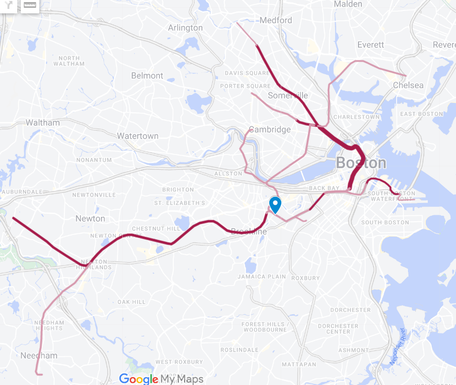
View attachment 45053
At a high level, I think this exchange illustrated that in a post-Fairmount world, a Nubian-downtown "subway" (grade-separated route directly into downtown) is sitting on the edge of build and no-build in cost-effectiveness. This applies to many aspects: ridership, speed, reliability, frequency, benefits to the rest of the network, and engineering cost.
At that point, it really becomes a personal choice whether you want to have it or not. Personally, I support it for all reasons mentioned above. But I can see arguments for the oppsite.
A few more minor points regarding this specific comment:
- The drawbacks of the Temple Pl "terminal" will continue to apply for a realistic LRT route. It will likely short-turn at either Park or Government Center, both of which are loops that do not allow holding trains for headway control. They won't help much with operations, either.
- Shorter boarding times may be offset by slower acceleration of LRT compared to BRT.
- The Park St platform expansions feel like a solution looking for a problem. I don't think having multiple lines share a platform is a big deal, especially when their routes have high degrees of overlap. All the reconfigured Green route destinations - Riverside, Needham and Heath St - are highly similar and can work with one platform. Similarly, if we have both the Washington LRT and the Nubian subway, their platforms can be combined as well. Lastly, 2-car Type 10s will completely change the existing platform assignments, so platform sharing will have to become commonplace regardless.
- You did make a strong argument that the Park-GC routing is more ideal than the South Station routing (edit: for Nubian residents, not for LMA workers), but that's exactly why the proposals of a Nubian subway on this board primarily focus on the Park-GC routing. Also, the same issues apply to Fairmount - which only gets you to South Station until NSRL, and even then may not get you Blue Line unless a Central Station is built.
Last edited:
Teban54
Senior Member
- Joined
- Nov 13, 2021
- Messages
- 1,142
- Reaction score
- 2,856
Moving this discussion here since it's clearly no longer about "MBTA Buses and Infrastructure".
The permanent solution that he gave does seem to require a tunnel. From a very quick search, it looks like cut-and-cover across rivers* is actually not as hopeless as you may think, though I haven't looked into the details yet. But regardless, if such a proposal comes from @F-Line to Dudley - who's famous for its cost-consciousness to the point where some proposals may seem to be from a dollar store - then I have more confidence that it can be done at reasonable costs.
* Shanghai has always been an interesting case to me in terms of construction. Like Boston, it also has a very complex set of conditions underground, to the extent where "experts" from decades ago deemed that the city wasn't suitable for subway construction. Yet, it now has 18 subway lines and is actively building more. Not sure how much of their land was filled, so can't make a comparison to Boston yet, but I'm far from an expert on subway construction anyway.
For one, both @F-Line to Dudley and @Riverside (where that map I linked came from) are explicitly assuming that a cross-LMA tunnel will not be built. F-Line has written various pieces on why he thinks a cross-LMA tunnel is literally impossible. You're free to disagree with them - and I'm generally more optimistic of a cross-LMA tunnel than they are - but this helps understand the context.
For another, even if a cross-LMA tunnel does get built, the question is: what do you use it for? This is best illustrated with the following proposal from @The EGE, who is indeed optimistic on a cross-LMA tunnel as a "Crazy Engineering Pitch":
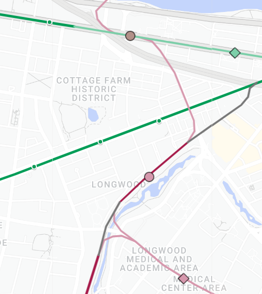
(All pieces from The EGE on this topic: one, two, three)
The idea: A cross-LMA tunnel is just as desirable for a radial route (via Huntington) as it is for a circumferential route, if not more. This route gives you direct access to the heart of LMA from Back Bay, South Station, North Station and Seaport... All big names. Even with as much circumferential service as you can realistically build, majority of LMA commutes will likely still come from the downtown core via transfers.
And the best part is: You don't have to choose whether you're doing a radial route or a circumferential route - you can have both! As elegantly shown above. But you'll only reap this benefit if you build it as (heavy-metro, grade-separated) LRT.
I realize that "LRT vs HRT" is a separate question from "TBM vs other grade-separated methods". But TBM isn't the definitive answer to the second question either - as The EGE sketched above, there is a theoretical possibility to land the tunnel on the Highland Branch. Then it may be possible to do a low-cost approach to land onto a Comm Ave subway, where C&C is definitely doable due to no utilities. That gets you to the BU bridge. If this is feasible, it's the cheapest way by far to navigate through the LMA-Kendall segment, while still giving you grade separation all the way to Main St Cambridge (or possibly Mass Ave if you're pessimistic about that one).
Finally, circling back to the original point of the Harvard branch: Whether cross-LMA is built as a TBM subway doesn't reduce the cost of a full LMA-Harvard subway. Yes, you may save some fixed costs, but my prior belief is that variable costs of TBMs are just as much as fixed costs if not more. It's not like you get the other 3 miles of subway for free if you build the 0.5-0.8 mile cross-LMA.
(Note: I have to say that I'm increasingly skeptical of the Highland-Longwood wye shown above, specifically, about flood mitigations for opening up a portal on the Highland Branch just next to the river. It's possible that the northern lag may need to be tunneled under Brookline Ave instead, while the southern lag need to be underground beneath Highland until Aspinwall Ave. Regardless, most of my points still stand.)
Both are detailed in the F-Line proposal above. The supposed "Harvard-reserved ROW" (despite little amounts of official details) would allow no street running in mixed traffic in Lower Allston, and grade separation at all junctions via open cuts. So the only temporary part would be street-running north of the river and on the Anderson Bridge (Kennedy St).Correct me if I'm wrong, but:
- It certainly seems like this would involve a tunnel under the river
- The alternative seems to be very heavy street running, which is... not great. If we want a cheap 'temporary' solution, we should just run buses into the existing bus tunnel.
The permanent solution that he gave does seem to require a tunnel. From a very quick search, it looks like cut-and-cover across rivers* is actually not as hopeless as you may think, though I haven't looked into the details yet. But regardless, if such a proposal comes from @F-Line to Dudley - who's famous for its cost-consciousness to the point where some proposals may seem to be from a dollar store - then I have more confidence that it can be done at reasonable costs.
* Shanghai has always been an interesting case to me in terms of construction. Like Boston, it also has a very complex set of conditions underground, to the extent where "experts" from decades ago deemed that the city wasn't suitable for subway construction. Yet, it now has 18 subway lines and is actively building more. Not sure how much of their land was filled, so can't make a comparison to Boston yet, but I'm far from an expert on subway construction anyway.
Well, if you want to do the phased-build approach that F-Line suggested, it will have to be light rail regardless (at least initially). But the other reason is what the branch will connect to beyond West Station and BU, as discussed below.
- Even if it avoids this problem, why light rail? This is a fully grade separated route,
Like I already said in the buses thread, I'm very pessimistic that a full deep-bored tunnel that's almost 4 miles long (Harvard-LMA via 66) is gonna fly in today's political climate. But aside from that:
- and we'd presumably want to connect it to a LMA tunnel, which would also need to be deep bored and fully grade separated. Given that we've now spent about 90% of the cost of a new subway line, let's just build a new subway line.
For one, both @F-Line to Dudley and @Riverside (where that map I linked came from) are explicitly assuming that a cross-LMA tunnel will not be built. F-Line has written various pieces on why he thinks a cross-LMA tunnel is literally impossible. You're free to disagree with them - and I'm generally more optimistic of a cross-LMA tunnel than they are - but this helps understand the context.
For another, even if a cross-LMA tunnel does get built, the question is: what do you use it for? This is best illustrated with the following proposal from @The EGE, who is indeed optimistic on a cross-LMA tunnel as a "Crazy Engineering Pitch":
(All pieces from The EGE on this topic: one, two, three)
The idea: A cross-LMA tunnel is just as desirable for a radial route (via Huntington) as it is for a circumferential route, if not more. This route gives you direct access to the heart of LMA from Back Bay, South Station, North Station and Seaport... All big names. Even with as much circumferential service as you can realistically build, majority of LMA commutes will likely still come from the downtown core via transfers.
And the best part is: You don't have to choose whether you're doing a radial route or a circumferential route - you can have both! As elegantly shown above. But you'll only reap this benefit if you build it as (heavy-metro, grade-separated) LRT.
I realize that "LRT vs HRT" is a separate question from "TBM vs other grade-separated methods". But TBM isn't the definitive answer to the second question either - as The EGE sketched above, there is a theoretical possibility to land the tunnel on the Highland Branch. Then it may be possible to do a low-cost approach to land onto a Comm Ave subway, where C&C is definitely doable due to no utilities. That gets you to the BU bridge. If this is feasible, it's the cheapest way by far to navigate through the LMA-Kendall segment, while still giving you grade separation all the way to Main St Cambridge (or possibly Mass Ave if you're pessimistic about that one).
Finally, circling back to the original point of the Harvard branch: Whether cross-LMA is built as a TBM subway doesn't reduce the cost of a full LMA-Harvard subway. Yes, you may save some fixed costs, but my prior belief is that variable costs of TBMs are just as much as fixed costs if not more. It's not like you get the other 3 miles of subway for free if you build the 0.5-0.8 mile cross-LMA.
(Note: I have to say that I'm increasingly skeptical of the Highland-Longwood wye shown above, specifically, about flood mitigations for opening up a portal on the Highland Branch just next to the river. It's possible that the northern lag may need to be tunneled under Brookline Ave instead, while the southern lag need to be underground beneath Highland until Aspinwall Ave. Regardless, most of my points still stand.)
TheRatmeister
Senior Member
- Joined
- Sep 23, 2023
- Messages
- 1,584
- Reaction score
- 3,212
Some good points, although I'd like to clarify a misunderstanding that I wasn't very clear about: I don't think the full 4 mile tunnel is what should be built. I think we're generally in agreement that a tunnel across LMA is desirable, nor is it impossible. (Although again, it would need to be deep bored, not C&C.) This would end up being probably around 1.25 mi. The line would then surface, follow i90 to West Station, then travel on the surface/elevated across Harvard/Lower Allston, (As shown in the plan linked), before diving into a final short tunnel to link up with the existing tunnel at Harvard. This ends up being ~1.5 mi of tunneling.Moving this discussion here since it's clearly no longer about "MBTA Buses and Infrastructure".
Both are detailed in the F-Line proposal above. The supposed "Harvard-reserved ROW" (despite little amounts of official details) would allow no street running in mixed traffic in Lower Allston, and grade separation at all junctions via open cuts. So the only temporary part would be street-running north of the river and on the Anderson Bridge (Kennedy St).
The permanent solution that he gave does seem to require a tunnel. From a very quick search, it looks like cut-and-cover across rivers* is actually not as hopeless as you may think, though I haven't looked into the details yet. But regardless, if such a proposal comes from @F-Line to Dudley - who's famous for its cost-consciousness to the point where some proposals may seem to be from a dollar store - then I have more confidence that it can be done at reasonable costs.
* Shanghai has always been an interesting case to me in terms of construction. Like Boston, it also has a very complex set of conditions underground, to the extent where "experts" from decades ago deemed that the city wasn't suitable for subway construction. Yet, it now has 18 subway lines and is actively building more. Not sure how much of their land was filled, so can't make a comparison to Boston yet, but I'm far from an expert on subway construction anyway.
Well, if you want to do the phased-build approach that F-Line suggested, it will have to be light rail regardless (at least initially). But the other reason is what the branch will connect to beyond West Station and BU, as discussed below.
Like I already said in the buses thread, I'm very pessimistic that a full deep-bored tunnel that's almost 4 miles long (Harvard-LMA via 66) is gonna fly in today's political climate. But aside from that:
For one, both @F-Line to Dudley and @Riverside (where that map I linked came from) are explicitly assuming that a cross-LMA tunnel will not be built. F-Line has written various pieces on why he thinks a cross-LMA tunnel is literally impossible. You're free to disagree with them - and I'm generally more optimistic of a cross-LMA tunnel than they are - but this helps understand the context.
For another, even if a cross-LMA tunnel does get built, the question is: what do you use it for? This is best illustrated with the following proposal from @The EGE, who is indeed optimistic on a cross-LMA tunnel as a "Crazy Engineering Pitch":
(All pieces from The EGE on this topic: one, two, three)
The idea: A cross-LMA tunnel is just as desirable for a radial route (via Huntington) as it is for a circumferential route, if not more. This route gives you direct access to the heart of LMA from Back Bay, South Station, North Station and Seaport... All big names. Even with as much circumferential service as you can realistically build, majority of LMA commutes will likely still come from the downtown core via transfers.
And the best part is: You don't have to choose whether you're doing a radial route or a circumferential route - you can have both! As elegantly shown above. But you'll only reap this benefit if you build it as (heavy-metro, grade-separated) LRT.
I realize that "LRT vs HRT" is a separate question from "TBM vs other grade-separated methods". But TBM isn't the definitive answer to the second question either - as The EGE sketched above, there is a theoretical possibility to land the tunnel on the Highland Branch. Then it may be possible to do a low-cost approach to land onto a Comm Ave subway, where C&C is definitely doable due to no utilities. That gets you to the BU bridge. If this is feasible, it's the cheapest way by far to navigate through the LMA-Kendall segment, while still giving you grade separation all the way to Main St Cambridge (or possibly Mass Ave if you're pessimistic about that one).
Finally, circling back to the original point of the Harvard branch: Whether cross-LMA is built as a TBM subway doesn't reduce the cost of a full LMA-Harvard subway. Yes, you may save some fixed costs, but my prior belief is that variable costs of TBMs are just as much as fixed costs if not more. It's not like you get the other 3 miles of subway for free if you build the 0.5-0.8 mile cross-LMA.
(Note: I have to say that I'm increasingly skeptical of the Highland-Longwood wye shown above, specifically, about flood mitigations for opening up a portal on the Highland Branch just next to the river. It's possible that the northern lag may need to be tunneled under Brookline Ave instead, while the southern lag need to be underground beneath Highland until Aspinwall Ave. Regardless, most of my points still stand.)
So, with that in mind:
Assuming GLRC, this (mostly) already exists. It's the Green Line. Yes, the walk from the Longwood/LMA stops is not ideal. But is eliminating it it worth permanently nuking 50% of capacity for on the entire rest of the line for? An orbital line would (Likely) serve places like Nubian, Kenmore, Kendall/Harvard, and potentially more. Again, also big names. Not to mention you're now linking the main orbital route, which is basically "The backup plan" in case something goes wrong on the GL, with the GL.The idea: A cross-LMA tunnel is just as desirable for a radial route (via Huntington) as it is for a circumferential route, if not more. This route gives you direct access to the heart of LMA from Back Bay, South Station, North Station and Seaport... All big names.
Teban54
Senior Member
- Joined
- Nov 13, 2021
- Messages
- 1,142
- Reaction score
- 2,856
While the question of "whether a 10-min walk from an 'LMA' station to hospitals is good enough" bears discussion, I think the same also applies to a circumferential route. There's nothing innate about riders from Harvard, Allston, Ruggles, Nubian etc that make them deserve a doorstep LMA connection more than riders from North/South Stations, Malden, Maverick etc. So if walking from LMA is reasonable for the latter, it's also reasonable for the former, at which point you save the expense of the cross-LMA subway altogether. In fact, this is exactly what @Riverside's map is hinting at: a low-cost solution that still provides access to LMA from all quadrants, possibly layered with additional services for circumferential riders going beyond LMA (e.g. T28 to Kenmore) and/or street-running routes across LMA (the 'H' Crimson Line in that proposal).Assuming GLRC, this (mostly) already exists. It's the Green Line. Yes, the walk from the Longwood/LMA stops is not ideal. But is eliminating it it worth permanently nuking 50% of capacity for on the entire rest of the line for? An orbital line would (Likely) serve places like Nubian, Kenmore, Kendall/Harvard, and potentially more. Again, also big names. Not to mention you're now linking the main orbital route, which is basically "The backup plan" in case something goes wrong on the GL, with the GL.
Regarding capacity:
- It appears that LRT can run shorter headways more easily than HRT, as seen from recent discussions about Arborway branch where F-Line implicitly called for 47 tph (78s headways) on the Green Line. This post suggests that some systems worldwide see 60 trams per hour (but notes that bunching is an issue, as was the case for our Green Line back when it ran just as frequently, as someone mentioned in that post). So if we have 1.5-min headways in the cross-LMA tunnel (which may be reasonable as it won't have as many curves as the Central Subway), this still gives you 3-min headways on each service pattern (BU-LMA-Ruggles and Reservoir-LMA-Back Bay), which seem good enough to me. Relaxing the numbers to 2-min and 4-min respectively can still work.
- Unless you build a quad-track Huntington subway, a cross-LMA D-E connector won't run full radial service anyways, due to the need to continue running some (half?) of Huntington trains to Heath St (or Arborway if you wish). This naturally means half of the capacity in the cross-LMA tunnel can be freed up for circumferential trains.
- In the event that the circumferential service's load becomes truly unbearable, and/or heavy rail conversion of the circumferential route(s) become highly desirable, there's always the option of building a separate tunnel for the radial D-E connector: either another deep bored tunnel via whichever east-west LMA street hasn't been chosen yet, or a more conventional D-E connector via Huntington and Mission Park. Given the cost of building two parallel subways in this area (even though/if the Mission Park connector should be much more feasible due to C&C), I feel that the political will to do it will (only?) be met much more easily if there are actual ridership numbers to support them.
TheRatmeister
Senior Member
- Joined
- Sep 23, 2023
- Messages
- 1,584
- Reaction score
- 3,212
I don't think I agree with this, at least in this specific case where (At least to some extent) "LRT" means "Connecting to the GL" and "HRT" means "Not doing that"It appears that LRT can run shorter headways more easily than HRT,
(You could make an LRT that doesn't connect to the GL, but like, why? Just use larger trains and have more capacity, there's clearly demand.)
The latter option opens up the possibility of a fully automated system, which would make high frequencies, way, way easier, not to mention reduced operating costs.
This is a fair point. If an orbital line could be built without the deep-level subway under Longwood that may be preferable. I'd be concerned about whether or not this is possible though given the fens and generally swampy nature of the area though. But you're right, it's not that Nubian/Harvard riders deserve a shorter walk, it's that a rail connection is needed between the two, with a stop at Longwood on the way. Given that, if the cost of adding a stop in the center of Longwood vs the periphery is about $0, then that's obviously preferable. If that is not the case, and an alignment that passes through Longwood rather than around the edge is significantly more expensive, then it's much more tricky.While the question of "whether a 10-min walk from an 'LMA' station to hospitals is good enough" bears discussion, I think the same also applies to a circumferential route. There's nothing innate about riders from Harvard, Allston, Ruggles, Nubian etc that make them deserve a doorstep LMA connection more than riders from North/South Stations, Malden, Maverick etc. So if walking from LMA is reasonable for the latter, it's also reasonable for the former, at which point you save the expense of the cross-LMA subway altogether.
Teban54
Senior Member
- Joined
- Nov 13, 2021
- Messages
- 1,142
- Reaction score
- 2,856
To clarify, I meant that the combined frequency of both circumferential BU-LMA-Ruggles trains and radial Reservoir-LMA-Back Bay trains (i.e. the maximum capacity that can be handled by a single trunk) seems to be better (or at least more easily doable) than the equivalent for HRT (e.g. Ashmont and Braintree trains combined, or the entire Orange Line).I don't think I agree with this, at least in this specific case where (At least to some extent) "LRT" means "Connecting to the GL" and "HRT" means "Not doing that"
TheRatmeister
Senior Member
- Joined
- Sep 23, 2023
- Messages
- 1,584
- Reaction score
- 3,212
This is going to be a little bit of a brain dump, but some urban ring thoughts:
Assumptions made in this post:
Primary destinations: Any urban ring plan must include these
Nubian-Longwood
My recommendation: Nubian-Ruggles-Longwood. Given that a station at Ruggles or Roxbury crossing would likely need to be below the SW corridor, and connect to a bored tunnel under Longwood, the only real savings from the Roxbury Crossing option would come from the tunnel between a C&C station at Nubian the SW corridor, which likely wouldn't justify the loss of ridership and connections.
Nubian-Waterfront
My pick: Probably option 2 or 3. Widett Circle/Andrew has major promise with for new developments, and good transport links could turn Widett Circle into a new Hudson Yards, for example. As for Southie vs Seaport, when the latter already has an existing radial transit line with potential for future growth, and is largely within walking distance of one of the largest transport nodes in the city, favoring it over an area with very few existing transport links and lots of potential for growth seems somewhat silly, but as a centralized commercial district rather than a spread out residential area, it may be better for an orbital line. It's all about priorities.
Longwood-Cambridge
Before we even decide on a route there's the question of picking which RL station to interchange with.
And there are also lots of route options:
My pick? I think Harvard is a station that's already built around transfers, and having it continue with this role going forward makes some sense. However, the increased number of 1-2 seat rides to Kendall would be a major benefit. (But as WFH contiunes to tear into office jobs, maybe adding service to what is at least partially a major office district isn't the best plan?) What I will say for sure is that unless a route to Central can be done entirely C&C, and the others can't, I don't think it really wins here. In terms of route, Kenmore or Lower Allston are both good options, although given that the 66 has generally had higher ridership than the 1 I'd argue a route closer to the former is a better option, which I would score as a point for CC+Lower Allston. Coolidge corner only isn't a bad option, but I think it's somewhat of a half measure that would be better going one way or the other.
Or maybe you could combine some of these to form a route with branches? There are lots of options.
Assumptions made in this post:
- A fully-grade separated urban ring is desirable for service quality/frequency
- We are not completely allergic to bored tunnels (This country will need a whole lot more of them, so we better figure it out if we are)
- C&C is cheaper than a bored tunnel, but without any stations the difference is less significant
Primary destinations: Any urban ring plan must include these
- Nubian
- Longwood Medical/Academic Area
- Somewhere in Cambridge, I'll return to this later
- Union Sq (Allston)
- Coolidge Corner
- Kenmore/Lansdowne
- Ruggles
- BUMC
- Southie (Just, generally)
- Seaport
- Sullivan
- Charlestown
- Union Sq (Cambridge)
- JFK/Columbia Point
- South Station
Nubian-Longwood
- Via Malcom X Blvd and Roxbury Crossing (C&C)
- Via Ruggles and Madison Park HS (Maybe C&C, probably TBM)
| Route | Pros | Cons |
| Via Roxbury Crossing | Could C&C under Malcolm X Blvd, making the intermediate tunnel cheaper | Loses out on CR connection and local ridership |
| Via Ruggles | Connects to CR and local ridership at Northeastern | May require a TBM for the Nubian-SW Corridor section |
My recommendation: Nubian-Ruggles-Longwood. Given that a station at Ruggles or Roxbury crossing would likely need to be below the SW corridor, and connect to a bored tunnel under Longwood, the only real savings from the Roxbury Crossing option would come from the tunnel between a C&C station at Nubian the SW corridor, which likely wouldn't justify the loss of ridership and connections.
Nubian-Waterfront
| Route | Pros | Cons |
| Nubian-South Station via 93 |
|
|
| Nubian-Seaport via Widett Circle/South Boston Bypass |
|
|
| Nubian-Southie via Widett Circle/Andrew |
|
|
| Nubian-JFK/Columbia Point via Newmarket |
|
|
Longwood-Cambridge
Before we even decide on a route there's the question of picking which RL station to interchange with.
| Station | Pros | Cons |
| Harvard |
|
|
| Central |
|
|
| Kendall |
|
|
And there are also lots of route options:
| Route | Pros | Cons |
| Via Kenmore |
|
|
| Via Coolidge Corner |
|
|
| Via Lower Allston (And CC) |
|
|
My pick? I think Harvard is a station that's already built around transfers, and having it continue with this role going forward makes some sense. However, the increased number of 1-2 seat rides to Kendall would be a major benefit. (But as WFH contiunes to tear into office jobs, maybe adding service to what is at least partially a major office district isn't the best plan?) What I will say for sure is that unless a route to Central can be done entirely C&C, and the others can't, I don't think it really wins here. In terms of route, Kenmore or Lower Allston are both good options, although given that the 66 has generally had higher ridership than the 1 I'd argue a route closer to the former is a better option, which I would score as a point for CC+Lower Allston. Coolidge corner only isn't a bad option, but I think it's somewhat of a half measure that would be better going one way or the other.
Or maybe you could combine some of these to form a route with branches? There are lots of options.
Last edited:
JeffDowntown
Senior Member
- Joined
- May 28, 2007
- Messages
- 5,075
- Reaction score
- 4,305
Excellent Discussion.This is going to be a little bit of a brain dump, but some urban ring thoughts:
Assumptions made in this post:
Where should (The southern half/two-thirds of) the urban ring go?
- A fully-grade separated urban ring is desirable for service quality/frequency
- We are not completely allergic to bored tunnels (This country will need a whole lot more of them, so we better figure it out if we are)
- C&C is cheaper than a bored tunnel, but without any stations the difference is less significant
Primary destinations: Any urban ring plan must include these
Secondary destinations: Some of these should be included
- Nubian
- Longwood Medical/Academic Area
- Somewhere in Cambridge, I'll return to this later
So with that in mind, what are some route options?
- Union Sq (Allston)
- Coolidge Corner
- Kenmore/Lansdowne
- Ruggles
- BUMC
- Southie (Just, generally)
- Seaport
- Sullivan
- Charlestown
- Union Sq (Cambridge)
- JFK/Columbia Point
- South Station
Nubian-Longwood
- Via Malcom X Blvd and Roxbury Crossing (C&C)
- Via Ruggles and Madison Park HS (Maybe C&C, probably TBM)
Route Pros Cons Via Roxbury Crossing Could C&C under Malcolm X Blvd, making the intermediate tunnel cheaper Loses out on CR connection and local ridership Via Ruggles Connects to CR and local ridership at Northeastern May require a TBM for the Nubian-SW Corridor section
My recommendation: Nubian-Ruggles-Longwood. Given that a station at Ruggles or Roxbury crossing would likely need to be below the SW corridor, and connect to a bored tunnel under Longwood, the only real savings from the Roxbury Crossing option would come from the tunnel between a C&C station at Nubian the SW corridor, which likely wouldn't justify the loss of ridership and connections.
Nubian-Waterfront
My pick: Probably option 2 or 3. Widett Circle/Andrew has major promise with for new developments, and good transport links could turn Widett Circle into a new Hudson Yards, for example. As for Southie vs Seaport, when the latter already has an existing radial transit line with potential for future growth, and is largely within walking distance of one of the largest transport nodes in the city, favoring it over an area with very few existing transport links and lots of potential for growth seems somewhat silly, but as a centralized commercial district rather than a spread out residential area, it may be better for an orbital line. It's all about priorities.
Route Pros Cons Nubian-South Station via 93
- Connects to all (Southern) CR lines
- Direct connection to downtown
- Finding space for more platforms at South Station could be... difficult
- Could split ridership with a Washington St route
Nubian-Seaport via Widett Circle/South Boston Bypass
- Shortest future tunnel under the Harbor
- Would supercharge further development in Seaport
- Would serve potential development at Widett Circle
- Likely the easiest route in terms of both avoiding bored tunnels and having easy station construction locations
- Interchange with RL at Broadway would be sub-par
- Doesn't connect with the CR without a new station at Widett Circle
Nubian-Southie via Widett Circle/Andrew
- Serves majorly transit-starved area with lots of local ridership
- Serves potential new developments at Widett Circle/Andrew
- Doesn't preclude future cross-harbor tunnel
- Would require a lot of C&C through built up areas. It's better than TBM, but it's still not cheap.
- Trying to hit Widett Circle/Andrew would be somewhat challenging, it could have some pretty tight curves
- Again, no CR interchange without infill station at Widett Circle
Nubian-JFK/Columbia Point via Newmarket
- Existing CR station/major bus hub
- Would split connections between 2 stations to avoid overcrowding
- Area between Nubian and JFK/UMass is a strip-mall wasteland that's less likely to see major new development
- Likely precludes any cross-harbor tunnel from happening
Longwood-Cambridge
Before we even decide on a route there's the question of picking which RL station to interchange with.
Station Pros Cons Harvard
- Existing stub platforms for an easy phase 1
- Existing major bus interchange
- Somewhat bleeding into the next section, but Harvard may actually be the easiest to get to since a surface segment through Lower Allston may be possible
- Lots of passengers would be connecting at Harvard, increasing the number of 2+ seat rides while the number of 1 seat rides would remain relatively small
- Likely the longest route once the northern half of the ring is considered
Central
- RL currently has excess capacity
- Connection would provide new service to Cambridgeport
- Even more transfers would be required than at Harvard
- No existing bus hub
- Likely requires the most bored tunnel
Kendall
- Existing ROW (Grand Junction)
- Huge employment center as well as significant source of local ridership from students
- RL transfer at Kendall would be pretty bad, and may run into issues with crowding
- Grade-separating the Grand Junction would be quite challenging. Any C&C tunneling would need to deal with the site literally being under buildings in some places, while surface/elevated running would need to deal with going over/under several major roads as well as the existing buildings.
And there are also lots of route options:
Route Pros Cons Via Kenmore
- Would connect with all GL branches+CR
- Serves major transport node with huge ridership during events at Fenway
- Would likely require the most tunneling
- Likely precludes any connection to Harvard
Via Coolidge Corner
- (Based on a rough estimate) Would require the least tunneling
- Likely precludes any connection to Harvard
- Only serves relatively minor destinations with existing transit links
Via Lower Allston (And CC)
- Potential for surface/elevated running through Lower Allston
- Direct routes to Harvard or Central
- Would connect with B & C branches
- Serves areas currently lacking rapid transit
- Any CR connection would require new West Station to be built
- Likely precludes any connection to Kendall
- Would likely need some weird backtracking and curves at the I90 interchange
My pick? I think Harvard is a station that's already built around transfers, and having it continue with this role going forward makes some sense. However, the increased number of 1-2 seat rides to Kendall would be a major benefit. (But as WFH contiunes to tear into office jobs, maybe adding service to what is at least partially a major office district isn't the best plan?) What I will say for sure is that unless a route to Central can be done entirely C&C, and the others can't, I don't think it really wins here. In terms of route, Kenmore or Lower Allston are both good options, although given that the 66 has generally had higher ridership than the 1 I'd argue a route closer to the former is a better option, which I would score as a point for CC+Lower Allston. Coolidge corner only isn't a bad option, but I think it's somewhat of a half measure that would be better going one way or the other.
Or maybe you could combine some of these to form a route with branches? There are lots of options.
I would like to point out one element of the CC versus TBM debate about cost. We only look at the direct project cost when we talk about these options. But the options also carry very different externalities costs (cost incurred by the public, but not directly captured by the project budget).
CC has a much higher economic and disruption impact on the entire route during construction. In some cases this might be so high as to impossible to bear (imaging hospital access disrupted in the Longwood area).
TBM has a much lower disruption and economic impact along its route. Impact it typically only felt at the TBM injection point and at station construction locations.
By not considering to total impact cost of the method, we relegate the public along the chosen route to a hidden tax throughout the construction period.
I want to turn to a slightly nitty-gritty topic, by way of some (over)simplifying abstraction.
There are lots of open questions about what could be done, transit-wise, in Chelsea. Does SL3 get extended? Do we build an Urban Ring? Is Regional Rail electrified and run through the NSRL? What kind of enhancements to radial service on the T111 and T116 are possible?
That all being said, we can be reasonably sure that, whatever gets built, it will fall into one of four corridors:

Even the most "out there" crazy transit pitch would only add one other potential corridor, along Route 1 (i.e. a heavy rail extension):

But for the most part, we're talking about those first four. Whether it's just high-frequency buses or full-out dual LRT lines, Washington and Broadway will both remain the major radial corridors, and the Grand Junction + Eastern Route is always going to be the main corridor running east-west.
So, my point is that the details of those implementations can be somewhat abstracted away.
Which brings up the nitty-gritty question: if the major corridors are over there to the east (circled in black), why have the Regional Rail station all the way the west (marked with the purple dot)?

Well, for one thing, you have to fit a platform. The old Chelsea station, to the west of Washington Ave, had short platforms (one of which is still partially extant) which couldn't be extended:

This means there are two questions here:
1) Should the Regional Rail station be relocated closer to the T111 and T116 corridors? Does that answer change with NSRL through-running?
2) If so, is there space for a relocated station, and if so, where?
On the question of space: looking at the (new) current Chelsea station, as well as the new center-platform Boston Landing station, a 2-track mainline station requires about 45 feet of ROW width. The tracks alone require about 30 feet of width. Rapid transit tracks require about 25 feet of width; the GLX stations require 45 feet of width (the GLX + Lowell total width is about 63 feet, by my measurements).
But, staggered stations might relieve some of the pressure to squeeze full-width stations side by side (75 feet at the rapid transit station, 70 feet at the mainline), something like this:

It looks to me that the ROW between Washington and Broadway is just about 70 feet. The ROW to the west widens a bit to 80 feet (actually wider than that if you include the old mainline platform, but its spacing seems like it would be mostly useless for tracks and platforms), though lengthening the current SL3 station to GLX size might be a little more challenging.
(I see that @F-Line to Dudley proposed killing the grade crossing at Arlington & 6th entirely, which would free up more space for the LRT platform.)
Setting aside the silliness of making the brand new Chelsea station obsolete, this raises the larger question about the role of the Regional Rail stations, the Circle Line services, and the necessities of transfers to/from the T111 and T116.
My take is that it makes sense to relocate the mainline station to Washington / Broadway after NSRL is built and mainline trains at Chelsea are through-run to South Station and beyond; at that point, being able to transfer from the T111 and T116 (a la Sullivan Square) becomes more valuable. Until then, mainline passengers who are commuting, e.g., Salem <> Airport can transfer to Circle services at the current Mystic Mall station.
Would frequent non-NSRL Regional Rail services tip the scales in favor of relocation? I still think probably not -- I don't see many T111 or T116 riders transferring to North Station-bound Regional Rail instead of riding to Haymarket or transferring at Maverick.
There are lots of open questions about what could be done, transit-wise, in Chelsea. Does SL3 get extended? Do we build an Urban Ring? Is Regional Rail electrified and run through the NSRL? What kind of enhancements to radial service on the T111 and T116 are possible?
That all being said, we can be reasonably sure that, whatever gets built, it will fall into one of four corridors:
- T111 (Washington Ave)
- T116 (Broadway)
- a "Circle" Line
- Regional Rail
Even the most "out there" crazy transit pitch would only add one other potential corridor, along Route 1 (i.e. a heavy rail extension):
But for the most part, we're talking about those first four. Whether it's just high-frequency buses or full-out dual LRT lines, Washington and Broadway will both remain the major radial corridors, and the Grand Junction + Eastern Route is always going to be the main corridor running east-west.
So, my point is that the details of those implementations can be somewhat abstracted away.
Which brings up the nitty-gritty question: if the major corridors are over there to the east (circled in black), why have the Regional Rail station all the way the west (marked with the purple dot)?
Well, for one thing, you have to fit a platform. The old Chelsea station, to the west of Washington Ave, had short platforms (one of which is still partially extant) which couldn't be extended:
This means there are two questions here:
1) Should the Regional Rail station be relocated closer to the T111 and T116 corridors? Does that answer change with NSRL through-running?
2) If so, is there space for a relocated station, and if so, where?
On the question of space: looking at the (new) current Chelsea station, as well as the new center-platform Boston Landing station, a 2-track mainline station requires about 45 feet of ROW width. The tracks alone require about 30 feet of width. Rapid transit tracks require about 25 feet of width; the GLX stations require 45 feet of width (the GLX + Lowell total width is about 63 feet, by my measurements).
- Mainline 2 tracks: 30 feet
- Mainline 2 tracks + platform: 45 feet
- Rapid transit 2 tracks: 25 feet
- Rapid transit 2 tracks + platform: 45 feet
But, staggered stations might relieve some of the pressure to squeeze full-width stations side by side (75 feet at the rapid transit station, 70 feet at the mainline), something like this:
It looks to me that the ROW between Washington and Broadway is just about 70 feet. The ROW to the west widens a bit to 80 feet (actually wider than that if you include the old mainline platform, but its spacing seems like it would be mostly useless for tracks and platforms), though lengthening the current SL3 station to GLX size might be a little more challenging.
(I see that @F-Line to Dudley proposed killing the grade crossing at Arlington & 6th entirely, which would free up more space for the LRT platform.)
Setting aside the silliness of making the brand new Chelsea station obsolete, this raises the larger question about the role of the Regional Rail stations, the Circle Line services, and the necessities of transfers to/from the T111 and T116.
My take is that it makes sense to relocate the mainline station to Washington / Broadway after NSRL is built and mainline trains at Chelsea are through-run to South Station and beyond; at that point, being able to transfer from the T111 and T116 (a la Sullivan Square) becomes more valuable. Until then, mainline passengers who are commuting, e.g., Salem <> Airport can transfer to Circle services at the current Mystic Mall station.
Would frequent non-NSRL Regional Rail services tip the scales in favor of relocation? I still think probably not -- I don't see many T111 or T116 riders transferring to North Station-bound Regional Rail instead of riding to Haymarket or transferring at Maverick.
TheRatmeister
Senior Member
- Joined
- Sep 23, 2023
- Messages
- 1,584
- Reaction score
- 3,212
In my recent fantasy map the option I went with for serving Chelsea was a full C&C subway under Broadway, which generally does a better job of hitting the major locations in Chelsea compared to the SL3 alignment. It can also be extended further into Revere Center, another major location with extremely high bus ridership that would significantly benefit from better transit.I want to turn to a slightly nitty-gritty topic, by way of some (over)simplifying abstraction.
There are lots of open questions about what could be done, transit-wise, in Chelsea. Does SL3 get extended? Do we build an Urban Ring? Is Regional Rail electrified and run through the NSRL? What kind of enhancements to radial service on the T111 and T116 are possible?
That all being said, we can be reasonably sure that, whatever gets built, it will fall into one of four corridors:
Looking something like this:
- T111 (Washington Ave)
- T116 (Broadway)
- a "Circle" Line
- Regional Rail
View attachment 46152
Even the most "out there" crazy transit pitch would only add one other potential corridor, along Route 1 (i.e. a heavy rail extension):
View attachment 46153
But for the most part, we're talking about those first four. Whether it's just high-frequency buses or full-out dual LRT lines, Washington and Broadway will both remain the major radial corridors, and the Grand Junction + Eastern Route is always going to be the main corridor running east-west.
So, my point is that the details of those implementations can be somewhat abstracted away.
Which brings up the nitty-gritty question: if the major corridors are over there to the east (circled in black), why have the Regional Rail station all the way the west (marked with the purple dot)?
View attachment 46154
Well, for one thing, you have to fit a platform. The old Chelsea station, to the west of Washington Ave, had short platforms (one of which is still partially extant) which couldn't be extended:
View attachment 46155
This means there are two questions here:
1) Should the Regional Rail station be relocated closer to the T111 and T116 corridors? Does that answer change with NSRL through-running?
2) If so, is there space for a relocated station, and if so, where?
On the question of space: looking at the (new) current Chelsea station, as well as the new center-platform Boston Landing station, a 2-track mainline station requires about 45 feet of ROW width. The tracks alone require about 30 feet of width. Rapid transit tracks require about 25 feet of width; the GLX stations require 45 feet of width (the GLX + Lowell total width is about 63 feet, by my measurements).
If a mainline station and rapid transit station are placed side-by-side, the ROW would probably need to be 90 feet wide. I don't really see any place within the circled area above that could accommodate that.
- Mainline 2 tracks: 30 feet
- Mainline 2 tracks + platform: 45 feet
- Rapid transit 2 tracks: 25 feet
- Rapid transit 2 tracks + platform: 45 feet
But, staggered stations might relieve some of the pressure to squeeze full-width stations side by side (75 feet at the rapid transit station, 70 feet at the mainline), something like this:
View attachment 46156
It looks to me that the ROW between Washington and Broadway is just about 70 feet. The ROW to the west widens a bit to 80 feet (actually wider than that if you include the old mainline platform, but its spacing seems like it would be mostly useless for tracks and platforms), though lengthening the current SL3 station to GLX size might be a little more challenging.
(I see that @F-Line to Dudley proposed killing the grade crossing at Arlington & 6th entirely, which would free up more space for the LRT platform.)
Setting aside the silliness of making the brand new Chelsea station obsolete, this raises the larger question about the role of the Regional Rail stations, the Circle Line services, and the necessities of transfers to/from the T111 and T116.
My take is that it makes sense to relocate the mainline station to Washington / Broadway after NSRL is built and mainline trains at Chelsea are through-run to South Station and beyond; at that point, being able to transfer from the T111 and T116 (a la Sullivan Square) becomes more valuable. Until then, mainline passengers who are commuting, e.g., Salem <> Airport can transfer to Circle services at the current Mystic Mall station.
Would frequent non-NSRL Regional Rail services tip the scales in favor of relocation? I still think probably not -- I don't see many T111 or T116 riders transferring to North Station-bound Regional Rail instead of riding to Haymarket or transferring at Maverick.
In terms of the southern side, the replacement of the Tobin Bridge in the near-ish future means there's a good opportunity to run a rail line across a new bridge, which would also then serve Charlestown, another underserved area, before meeting the OL at Community College and then doing... something, there's options. Regardless of what happens on the other side of the Mystic, my general thought is that Chelsea is well positioned to form the eastern segment of an urban ring route. In the bigger picture, a lot of transfers would likely be made to the OL at Community College, likely necessitating increased frequencies south of Sullivan. Maybe this could be combined with another C&C subway under Broadway (The Everett one) that branches off the OL?
Yeah, the southern half of that is similar to what The EGE proposes:In my recent fantasy map the option I went with for serving Chelsea was a full C&C subway under Broadway, which generally does a better job of hitting the major locations in Chelsea compared to the SL3 alignment. It can also be extended further into Revere Center, another major location with extremely high bus ridership that would significantly benefit from better transit.
In terms of the southern side, the replacement of the Tobin Bridge in the near-ish future means there's a good opportunity to run a rail line across a new bridge, which would also then serve Charlestown, another underserved area, before meeting the OL at Community College and then doing... something, there's options. Regardless of what happens on the other side of the Mystic, my general thought is that Chelsea is well positioned to form the eastern segment of an urban ring route. In the bigger picture, a lot of transfers would likely be made to the OL at Community College, likely necessitating increased frequencies south of Sullivan. Maybe this could be combined with another C&C subway under Broadway (The Everett one) that branches off the OL?
And there are a lot of potential alignments you can do for that, but yeah, I'd connect it to a new heavy rail subway under Congress St.For a Red X, I much prefer either going to Chelsea and/or Everett. If this is the last change to create a new trunk line through downtown, it doesn't make sense to exclude them. Here's my crayon sketch of a potential route:
View attachment 7176
Stations at City Square, Bunker Hill/Medford Street, Chelsea, Bellingham Square (GL), [option for Revere Beach Parkway], Everett, Glendale Square, then a couple possibilities for the northern end. You could also do a straighter shot across the Mystic to hit the potential power station redevelopment instead, trading a shorter alignment for missing Chelsea.
I agree that Broadway makes for a strong corridor for rapid transit. I think a Kendall LRT line would be a very interesting candidate for it, and it could be paired with a branch along Everett's Broadway as well.
I went far down the crayoning rabbit hole here, well outside the bounds of feasibility, but useful as a point of imagination:
- Bronze Line: radiates outward from Kendall, with dual branches into Everett/Malden and Chelsea/Revere, meeting at a new transfer station on Route 1
- Red Line (via Congress St): radiates outward from Downtown, providing direct service into downtown Chelsea, and then providing express service from bus transfer points at Revere Beach Parkway, Park Ave, and the transfer terminal at Route 1
- Silver Line: radiates outward from Airport, with dual branches to Wellington/Davis and into Everett/Malden
The Red Line follows Route 1, which in general is not best practice (because people don't want to live near highways), but I think is more defensible here given the likely station locations.
~~~
But in any case, all this brings us back to the original question: even in the above full build-out, do you keep the Regional Rail station at Mystic Mall? Or do you relocate it back east?
BosMaineiac
Active Member
- Joined
- Nov 25, 2020
- Messages
- 248
- Reaction score
- 453
I swear it’s purely coincidence I mentioned the EL on Rt 1 in the other thread and you’re showing a line along the same route hereBut in any case, all this brings us back to the original question: even in the above full build-out, do you keep the Regional Rail station at Mystic Mall? Or do you relocate it back east?
") . I’ve always imagined your red line diverting from Rt 1 briefly along Everett Ave to a large, consolidated Chelsea Sta. at Mystic Mall. I think that‘s prime land for a sort of “New Downtown” for Chelsea, and you can maintain a good connection the current downtown with a station at the Rt 1/Everett Ave interchange
. I’ve always imagined your red line diverting from Rt 1 briefly along Everett Ave to a large, consolidated Chelsea Sta. at Mystic Mall. I think that‘s prime land for a sort of “New Downtown” for Chelsea, and you can maintain a good connection the current downtown with a station at the Rt 1/Everett Ave interchangeTeban54
Senior Member
- Joined
- Nov 13, 2021
- Messages
- 1,142
- Reaction score
- 2,856
Strictly for funsies only: I did propose this alignment for an alternative Urban Ring that runs down Everett Ave into more central areas of Chelsea and then Eastern Ave (which I'm sure you know). It's a consideration for a deep bored tunnel across Chelsea Creek that does not depend on the suspension bridge: if we're spending the $$$ for it, might as well bore it in a way that serves Chelsea better. But otherwise, I agree that it doesn't fundamentally change your analysis.Even the most "out there" crazy transit pitch would only add one other potential corridor, along Route 1 (i.e. a heavy rail extension):
View attachment 46153
But for the most part, we're talking about those first four. Whether it's just high-frequency buses or full-out dual LRT lines, Washington and Broadway will both remain the major radial corridors, and the Grand Junction + Eastern Route is always going to be the main corridor running east-west.
On the question of space: looking at the (new) current Chelsea station, as well as the new center-platform Boston Landing station, a 2-track mainline station requires about 45 feet of ROW width. The tracks alone require about 30 feet of width. Rapid transit tracks require about 25 feet of width; the GLX stations require 45 feet of width (the GLX + Lowell total width is about 63 feet, by my measurements).
If a mainline station and rapid transit station are placed side-by-side, the ROW would probably need to be 90 feet wide. I don't really see any place within the circled area above that could accommodate that.
- Mainline 2 tracks: 30 feet
- Mainline 2 tracks + platform: 45 feet
- Rapid transit 2 tracks: 25 feet
- Rapid transit 2 tracks + platform: 45 feet
But, staggered stations might relieve some of the pressure to squeeze full-width stations side by side (75 feet at the rapid transit station, 70 feet at the mainline), something like this:
View attachment 46156
It looks to me that the ROW between Washington and Broadway is just about 70 feet. The ROW to the west widens a bit to 80 feet (actually wider than that if you include the old mainline platform, but its spacing seems like it would be mostly useless for tracks and platforms), though lengthening the current SL3 station to GLX size might be a little more challenging.
I'm not sure if 70-75 ft is enough for a platform and 4 tracks. The four GLX stations alongside Lowell Line all measure almost exactly 80 ft, even in areas tightly constrained on space, like Ball Square:
Having said that, there do seem to be plenty of examples of commuter rail platforms that are 10 ft wide. Your maximum for the CR platform will be 10-15 ft here, which is certainly less than ideal, but may be doable for a single island platform.
A minor correction to your diagram is that the 800 ft CR platform needs to span underneath and east of Broadway, as the distance between Washington Ave and Broadway is only 640 ft. But that should be pretty doable as the crossing under Broadway is quite spacious.
A few factors to keep in mind:Setting aside the silliness of making the brand new Chelsea station obsolete, this raises the larger question about the role of the Regional Rail stations, the Circle Line services, and the necessities of transfers to/from the T111 and T116.
My take is that it makes sense to relocate the mainline station to Washington / Broadway after NSRL is built and mainline trains at Chelsea are through-run to South Station and beyond; at that point, being able to transfer from the T111 and T116 (a la Sullivan Square) becomes more valuable. Until then, mainline passengers who are commuting, e.g., Salem <> Airport can transfer to Circle services at the current Mystic Mall station.
Would frequent non-NSRL Regional Rail services tip the scales in favor of relocation? I still think probably not -- I don't see many T111 or T116 riders transferring to North Station-bound Regional Rail instead of riding to Haymarket or transferring at Maverick.
- The T111 is the second most frequent bus route in the BNRD (only behind the combined SL4/5), and the T116 is also slightly more frequent than other Frequent "T" Bus Routes, mostly due to off-peak frequencies. (In terms of # trips per weekday, the T116 is only behind SL4/5, T111, T32, T57 and T1 in this order, and tied with T28.) So yes, I do think it's very worthwhile to improve connection from the T111/T116 to both CR and Urban Ring.
- If you want to promote both T111 and T116 to true BRT (or even street-running LRT), the Washington Ave bridge only has space for 3 travel lanes. This means a very plausible approach will be to set up one transit lane in each direction along Washington Ave, Broadway and Cary Ave, and reroute both T111 and T116 like below. This is a scenario that further increases the need for connections at Broadway (i.e. not just Washington Ave).
Another note is that there's a need for better connection from Urban Ring to Broadway, which can be achieved by moving Box District station further west.
To be clear, I agree that Broadway from Chelsea to Revere deserves better radial transit, and I even made god-mode proposals for it before. But in reality, I'm not sure if a subway will be built there even with C&C. Broadway is heavily residential, so the drawbacks of C&C - which ironically Jeff just pointed out above - will be especially salient. (Put it another way, the political challenges for a Chelsea-Revere C&C tunnel are almost exactly the same as the 66 corridor from Charles River to Muddy River, and you know my opinions on that.)In my recent fantasy map the option I went with for serving Chelsea was a full C&C subway under Broadway, which generally does a better job of hitting the major locations in Chelsea compared to the SL3 alignment. It can also be extended further into Revere Center, another major location with extremely high bus ridership that would significantly benefit from better transit.
How sure are we about that? I certainly hope so, and IIRC the design guidelines require bus lanes, but I'm not sure if they will necessarily be built in a way that allows (easy) conversion to rail in the future. The grades from I-93 to the river may also be too steep for an intermediate station in Charlestown.In terms of the southern side, the replacement of the Tobin Bridge in the near-ish future means there's a good opportunity to run a rail line across a new bridge
This would be a good fit for F-Line's "Red X" proposal. (Which is surprisingly ambitious by F-Line standards.)which would also then serve Charlestown, another underserved area, before meeting the OL at Community College and then doing... something, there's options.
Any OL branch that cuts the frequencies of Malden, Wellington and Assembly permanently in half is a non-starter, not to mention this proposal even hurts Sullivan. The real-world MBTA Orange Line Transformation aims for 3-min headways, which demonstrates a real need for that coming from Malden, and cutting that to 6 min will make you even worse off than pre-Covid levels. Having 3-min headways on both branches require 1.5-min headways downtown, which only the absolute top tier heavy rail systems worldwide can achieve.Maybe this could be combined with another C&C subway under Broadway (The Everett one) that branches off the OL?
(Edit: Branching OL was discussed here, but I stand by my original opinion. All the OL Transformation work shouldn't result in a downgrade to 6-min frequency with no way of improving further.)
To clarify, are your Bronze Line Everett/Revere branches grade separated in this scenario? If they're not (which itself is reasonable given the Red X), then I don't see the two Silver Line branches being grade separated either, especially the Malden branch.I went far down the crayoning rabbit hole here, well outside the bounds of feasibility, but useful as a point of imagination:
View attachment 46161
Last edited:
Hahaha, I think it is indeed coincidence and that I only saw your post afterward.I swear it’s purely coincidence I mentioned the EL on Rt 1 in the other thread and you’re showing a line along the same route here
That is an interesting idea about diverting down Everett Ave. A T111 connection would still be possible at Everett Ave/Rt 1, but the T116 is harder to swing (which certainly isn't the end of the world, but is a downside).
Hmm, yeah I need to look at that again. The impression I get is that the new standard is for platforms to be at least 15 feet wide. So that may well be the fatal flaw here.I'm not sure if 70-75 ft is enough for a platform and 4 tracks. The four GLX stations alongside Lowell Line all measure almost exactly 80 ft, even in areas tightly constrained on space, like Ball Square:
....
Having said that, there do seem to be plenty of examples of commuter rail platforms that are 10 ft wide. Your maximum for the CR platform will be 10-15 ft here, which is certainly less than ideal, but may be doable for a single island platform.
Yes, great point here.If you want to promote both T111 and T116 to true BRT (or even street-running LRT), the Washington Ave bridge only has space for 3 travel lanes. This means a very plausible approach will be to set up one transit lane in each direction along Washington Ave, Broadway and Cary Ave, and reroute both T111 and T116 like below. This is a scenario that further increases the need for connections at Broadway (i.e. not just Washington Ave).
It seems like this is what we are landing on. That said, the walk down to Box District station from Broadway is actually pretty short, so a relocation might not be super urgent.Another note is that there's a need for better connection from Urban Ring to Broadway, which can be achieved by moving Box District station further west.
Honestly I didn't even think about it to that level of detail. Yes, in any slightly realistic version of this, both Silver and Bronze are surface-running. But, that in turn makes it hard to run them to the full length sketched out here -- probably would be slightly more realistic with the western branch truncated to Glendale and the eastern branch truncated to... idk, Park Ave or Chelsea Common?To clarify, are your Bronze Line Everett/Revere branches grade separated in this scenario? If they're not (which itself is reasonable given the Red X), then I don't see the two Silver Line branches being grade separated either, especially the Malden branch.