Crazy Transit Pitches

Apologies for not being clearer in my terminology! Yeah, @TheRatmeister, @Teban54, and @kdmc are all correct in their interpretations.

Yeah, this is where my lack of knowledge is. I was envisioning something where the cars stop entirely, but the image in my mind was of something like London's; sure enough, while their cabs do slow down a huge amount, it looks like they remain in constant motion.

Ironically, I had figured they'd have a system like (street-running) cable cars, where the cab "unclamps" from the cable when halting in order to decelerate and stop. But I guess probably they don't want to make it physically possible for a cab to disconnect from the cable, lest a failure occur midair. (Still seems like it should be a solvable problem, but...)

It sounds like we would need an aerial tram in order to provide a viable passenger experience. But, it also sounds like aerial trams would be too slow and too infrequent to provide a viable service.

So. This idea is probably DOA.
I'm sure you could come up with some system to have all cars come to a stop, but now you're looking at developing a niche, one off system when you could also just not and put the parking somewhere else and save loads of money.

In the event someone does invent such a system, maybe it would be practical. But until then, yeah probably not.
 
How sufficient would it be to just have the cable car move slowly enough while in the station, so that passengers with luggage have enough time to get on and off?
 
How sufficient would it be to just have the cable car move slowly enough while in the station, so that passengers with luggage have enough time to get on and off?
That's an awfully variable condition. How many bags? How heavy and/or bulky are the bags? Are they elderly or with children? And so on. I doubt you could narrow it down to one reference figure that covers the spread. Somebody's always going to get stuck with one dwell setting.

Hell...this has proven to be a variable-dwell problem on SL1, nevermind a gondola that can't/doesn't fully stop.
 
How sufficient would it be to just have the cable car move slowly enough while in the station, so that passengers with luggage have enough time to get on and off?
I would consider it to be a big problem. Maybe for carry ons and lighter bags it would be fine, but the people who are driving to and parking at the airport are disproportionately going to be families and people with huge, bulky suitcases. Those are hard enough to move when the door you're trying to go through isn't moving away from you.
 
I'm sure you could come up with some system to have all cars come to a stop, but now you're looking at developing a niche, one off system when you could also just not and put the parking somewhere else and save loads of money.

In the event someone does invent such a system, maybe it would be practical. But until then, yeah probably not.
Oh yeah, I wasn’t advocating a one-off build for this system — I meant that it seems like a problem the larger market could solve.

I do think there is value beyond just linking the parking. Getting a service across Chelsea Creek to a transfer station at Eastern Ave could have use from an Urban Ring perspective overall.
How sufficient would it be to just have the cable car move slowly enough while in the station, so that passengers with luggage have enough time to get on and off?
The cars in the video I linked do indeed move very very very slowly, but it sounds to me like one of those things you can get away with under European accessibility laws but potentially not under ADA (which is the rare, if not sole, area where our regs are more stringent).
 
Thanks for the explanations! As a skier, I encounter many of these types of systems in the mountains, but I wasn't sure that was what was being referred to. I'll summarize my understanding now, with some research for clarification, as I believe this may be helpful for others who got lost in the terminology, but please feel free to correct me:
  • A people mover or automoated people mover (APM) system is automated (not requiring an onboard driver), running on dedicated tracks on a fixed guideway, with vehicles that have a medium capacity (10 to 50 passengers). This term is generic with respect to propulsion as they can be powered via a third rail, on board electric battery, or even by cables.
  • A cable car system (or cable transport system, more generally) is a broad class that refers to ones in which vehicles are being moved on cableways. The term cable car can be used to refer to any in the entire class of systems, or specifically just to one of its sub-classes. There are multiples types of cable transport systems, including:
    • Aerial cable transport systems, also known as aerial lifts, are systems where the vehicles are suspended by a circulating cable loop, that itself is supported by a series of towers. In North America, the vehicles in aerial cable transport systems are usually called cabins, if they are enclosed. In these systems, the cable is both the track and the means of propulsion and there is no onboard driver. The two most relevant types of aerial cable transport systems for this discussion are:
      • Aerial tramways, which are slightly higher capacity (20 to 100 passengers in each cabin), but generally only have one or two cabins in the entire system. The cabins are fixed to the cable and move when the cable moves. The entire system stops when passengers are boarding or alighting.
      • Gondola lifts, which consists of many lower-capacity cabins (4 to 15 passengers each) continuously circulating on the looped cable. Cabins can be detached from the cable for loading and unloading at stations, allowing for a continuous flow of cabins and passengers without stopping the entire system, but the cabins themselves generally don't ever come to a complete stop.
    • Ground cable cars (which people in North America just call "cable cars" but the British appropriately call cable trams) are trams/streetcars that operate on the ground, usually on tracks, and use cables as a form of propulsion.
The discussion here is focusing on gondola lifts, which to reiterate, is a type of aerial cable transport with lower-capacity cabins. As I understand:

Pros of Gondola Lifts:
  • Terrain Navigation: They can easily navigate difficult terrains like rivers, valleys, and steep inclines without extensive ground-level infrastructure modifications.
  • Low Ground Impact: Since they travel above the ground, they require less space and are less disruptive to existing roads and buildings.
Cons of Gondola Lifts:
  • Capacity Limitations: Each cabin has a limited capacity, which might not be suitable for very high-volume transport needs.
  • Weather Sensitivity: Operations can be affected by high winds, lightning, or heavy snow, potentially leading to service interruptions.
  • Speed: While faster than being stuck in traffic, they're typically slower than trains or metro systems, making them less suitable for longer distances.
Could Be a Pro and Could Be a Con of Gondola Lifts:
  • Continuous Flow: Gondola systems typically do not come to a complete stop for loading and unloading passengers. This allows for continuous operation, reducing wait times for passengers, however it also makes loading and unloading more challenging, particularly for those with mobility issues.
 
Last edited:
but it sounds to me like one of those things you can get away with under European accessibility laws but potentially not under ADA (which is the rare, if not sole, area where our regs are more stringent).
I believe the one in London can come to a full stop upon request if someone needs boarding assistance which is fine for infrequent passengers who only need 15-30 seconds, but when every other passenger needs practically a full minute that's most definitely not an option.
 
I believe the one in London can come to a full stop upon request if someone needs boarding assistance which is fine for infrequent passengers who only need 15-30 seconds, but when every other passenger needs practically a full minute that's most definitely not an option.

This feature is also how these aerial cable transport systems work at ski areas. Whether it is a gondola lift, an aerial tramway, or a chairlift, there is an operater at each station/terminal. The operater can slow and halt the entire system in the case that somebody needs assistance. It is not unusual for this occurrence to add extensive time to ones trip up the mountain.
 
My takeaway from all this is that the Chelsea Creek crossing (if grade separated) may be best bundled together into some sort of Massport solution -- or, maybe more precisely, that whatever mode gets built to serve the individual terminals at Logan, that same mode should also cross Chelsea Creek. Between potentially needing to duck into mixed traffic over the bridge, potentially being blocked by bridge openings, and the need to service the terminals directly, the corridor starting at Eastern Ave and heading south has notably different characteristics and needs than the Grand Junction to the north and west, and more in common with Logan Airport itself.

(Also, if building a crossing over Chelsea Creek, the ability to climb a steeper grade takes on greater importance, as evidenced by @Teban54's analysis of required incline length.)

I'll summarize my understanding now, with some research for clarification, as I believe this may be helpful for others who got lost in the terminology, but please feel free to correct me:
Excellent summary! The only point I'd add:
A people mover or automated people mover (APM) system is automated (not requiring an onboard driver), running on dedicated tracks on a fixed guideway, with vehicles that have a medium capacity (10 to 50 passengers). This term is generic with respect to propulsion as they can be powered via a third rail, on board electric battery, or even by cables.
The other thing to be aware of about APMs is that (AFAIK) there is not a lot of standardization. Gauge notwithstanding, trains around the world basically operate the same (aside from differences in propulsion) -- if you buy cars from Bombardier in 2000, you'll be fine buying cars from Siemens in 2010; while there are some vendors that make cookie-cutter APMs, there's a lot of variability between vendors, and you are basically locked in to the same vendor for the entire lifetime of the system. If that vendor goes out of business, you're kinda SOL unless you find another company willing to pick up support for a product that isn't theirs. This gives APMs a bit of a bad reputation because they often become burdensome.

If I understand correctly, it was historically worth distinguishing an APM from other modes because (due to the sealed ROW and heavily controlled environment), it was easier to implement automated operation. But, in my decidedly amateur opinion, it is increasing a distinction without a physical difference; from what I can tell, most of what an APM historically did could now be done by a standard COTS elevated light rail system (maybe with the additional requirement of being narrow gauge). So the term "automatic people mover" is a little bit... odd these days.

I think the key points, though, are the automation and the medium capacity -- I think that's what most people are imagining (and care about) when advocating for APMs.
I believe the one in London can come to a full stop upon request if someone needs boarding assistance which is fine for infrequent passengers who only need 15-30 seconds, but when every other passenger needs practically a full minute that's most definitely not an option.
Yeah, I saw a still photo of someone in a wheelchair waiting, so I wondered whether they had the ability to stop like that. But yeah, I don't think that would be viable for an airport people mover service.
 
Most gondolas practical for transport are "detachable", rather than "fixed grip", meaning they can detach from the main haul rope to a slower moving rope at each of the terminals, but continue moving constantly.

However, Disney (of course) has shown that it's possible to shunt gondolas onto the parking rail to allow for stationary boarding to accommodate wheelchairs and strollers, though this is still definitely not what you want when nearly everyone will have big bags, as @TheRatmeister said.
 
You know. The creek isn't that wide. Something like 550 feet -- that's shorter than the walkway from Central Parking to Terminal E, and is comparable to the Winter Street Concourse.

So...

1704242404124.png


When I started sketching this, I was envisioning a bunch of escalators leading from an elevated station to a very high enclosed walkway. But then as I did more, I realized how darn high 170 feet is, and became skeptical of escalators. So, instead, let's imagine that there are London-style banks of high-speed elevators on both sides of the bridge, connecting to an elevated LRT station on the north side, and a surface-level BRT station on the southside.

I also belatedly realized that the walkway should be on the east side, to connect to the parking lot:

1704243292823.png


So, I mean... the questions become:

1) how friendly can this be made to passengers? Alight at the LRT platform, walk to the end of the station, take an elevator, take a moving sidewalk across the bridge, take an elevator, board a bus to your terminal...

2) how damn expensive will this be? especially compared to the other options. Because. Like. 170 feet is tall.
 
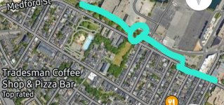
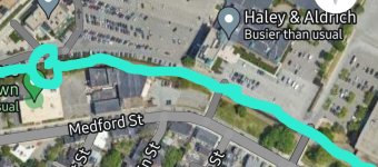
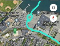
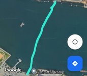
This has to be a Crazy Pitch, and this is my first route drawing, so I just started with a crayon route, so please forgive the casual design.

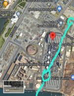
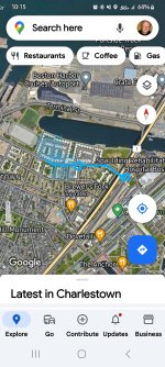
The pitch is to connect Charlestown to Downtown Everett via a Light Rail line which uses the old rail ROW along Medford St (some of which is now a park), then crosses the Mystic with a high enough concrete bridge which continues as an elevated line through the Exelon generation plant, then the soon to be transformed ExxonMobil gas tank farm, crossing over Rte 16, and then following above Broadway in Everett (or bore/ cut and cover underground). There would be a southern terminus at Chelsea St, with intermediate stops along Medford St at Charlestown High/Domino Development, Schraffts, NE Revs Development/Encore, the eventual gas tank development, Rte 16, and Downtown Everett.
 

Attachments

  • Screenshot_20240102_101538_Maps~2.jpg
    Screenshot_20240102_101538_Maps~2.jpg
    868 KB · Views: 56
  • Screenshot_20240102_102036_Maps.jpg
    Screenshot_20240102_102036_Maps.jpg
    678 KB · Views: 43
  • Screenshot_20240102_102114_Maps.jpg
    Screenshot_20240102_102114_Maps.jpg
    511.2 KB · Views: 52
  • Screenshot_20240102_102220_Maps.jpg
    Screenshot_20240102_102220_Maps.jpg
    893.3 KB · Views: 60
  • Screenshot_20240102_102257_Maps.jpg
    Screenshot_20240102_102257_Maps.jpg
    363.5 KB · Views: 46
  • Screenshot_20240102_102358_Maps.jpg
    Screenshot_20240102_102358_Maps.jpg
    1.6 MB · Views: 57
This has to be a Crazy Pitch, and this is my first route drawing, so I just started with a crayon route, so please forgive the casual design.

The pitch is to connect Charlestown to Downtown Everett via a Light Rail line which uses the old rail ROW along Medford St (some of which is now a park), then crosses the Mystic with a high enough concrete bridge which continues as an elevated line through the Exelon generation plant, then the soon to be transformed ExxonMobil gas tank farm, crossing over Rte 16, and then following above Broadway in Everett (or bore/ cut and cover underground). There would be a southern terminus at Chelsea St, with intermediate stops along Medford St at Charlestown High/Domino Development, Schraffts, NE Revs Development/Encore, the eventual gas tank development, Rte 16, and Downtown Everett.

Uh...is there a serious transit deficiency this would alleviate?

There's been much discussion around here of various pitches to address Everett's transit needs (and occasionally Charlestown's). I have to say, I fail to see what would be particularly useful or helpful about a LRT line connecting Everett and Charlestown that couldn't be more-or-less accomplished with competent Bus Rapid Transit. ("Competent" is doing the heavy lifting there, and trusting the MBTA to do BRT competently is...unwise.)

The need to cross the Mystic means the cost-benefit analysis is likely to be unfavorable for any service that lacks substantial network effects. The oft-discussed pitch of sending a Green Line/Urban Ring LRT branch up the Eastern Route past the casino and eating/sharing the SL3 would potentially bring connectivity to at least two of the airport, Kendall via Grand Junction, and/or the Central Subway. Your proposal would involve building a water crossing to get people from Everett to...Charlestown. With extremely limited places to go from there.

Even if all those proposed developments happen, I still don't see a case for more than BRT (which critically does not require a new water crossing) unless you're going somewhere past Charlestown. (North extension of the Congress Street subway idea, perhaps? Makes me wonder about a Congress Street Subway LRT Crazy Transit Pitch idea though 🤔)
 
This has to be a Crazy Pitch, and this is my first route drawing, so I just started with a crayon route, so please forgive the casual design.

The pitch is to connect Charlestown to Downtown Everett via a Light Rail line which uses the old rail ROW along Medford St (some of which is now a park), then crosses the Mystic with a high enough concrete bridge which continues as an elevated line through the Exelon generation plant, then the soon to be transformed ExxonMobil gas tank farm, crossing over Rte 16, and then following above Broadway in Everett (or bore/ cut and cover underground). There would be a southern terminus at Chelsea St, with intermediate stops along Medford St at Charlestown High/Domino Development, Schraffts, NE Revs Development/Encore, the eventual gas tank development, Rte 16, and Downtown Everett.
While using the Charlestown rail ROW for a route to Everett is likely not a good use of resources as @Brattle Loop said, I applaud you for thinking of it for transit use in the first place!

@Riverside has made another proposal in the past that suggested using this ROW for a more direct Urban Ring connection between Sullivan and Maverick/Airport, which I do think is a much better use of this corridor. A major advantage of this over the more typical Urban Ring route via the Eastern Route (Everett and Chelsea) is that it's much shorter and more direct link between northside OL and BL. The UR-via-Everett route is such a long detour that someone travelling from Malden to Airport (or worse, to Wonderland) will be better off transferring downtown instead. That will not be the case with UR-via-Charlestown.

The problem is that it still doesn't avoid the river crossing that Eastern Route needs to deal with, and it will need to be a tunnel, massively inflating the cost. The standalone demand between OL and BL may not be enough to warrant such a service; and while Charlestown deserves better transit, this is probably the wrong way to do it, and probably not enough for its cost-effectiveness to outweigh the Eastern Route.

But this does get to the point of: The conventional Urban Ring via Everett and Chelsea is not really serving as a circumferential route. Rather, it's a radial route that specifically serves Everett and Chelsea, and that's a very loose definition of "radial" - you either have to think of it as being anchored at Kendall, or as a OL/BL feeder for downtown riders. This comes back to @Riverside's point earlier about splitting service at Chelsea... Which I'll get to, hopefully in just a moment.
 
The real purpose of Everett and Chelsea segments of Urban Ring?

TL;DR: On a closer inspection, the need for a continuous Urban Ring service from Sullivan to Airport - or even that of a better Chelsea Creek crossing for transit - really isn't nearly as high as you may think, and definitely not worth the hassle of building an expensive river crossing.


My takeaway from all this is that the Chelsea Creek crossing (if grade separated) may be best bundled together into some sort of Massport solution -- or, maybe more precisely, that whatever mode gets built to serve the individual terminals at Logan, that same mode should also cross Chelsea Creek. Between potentially needing to duck into mixed traffic over the bridge, potentially being blocked by bridge openings, and the need to service the terminals directly, the corridor starting at Eastern Ave and heading south has notably different characteristics and needs than the Grand Junction to the north and west, and more in common with Logan Airport itself.
Yes yes yes. This even extends beyond the Massport needs: the route south of Chelsea Creek, to Airport (either BL or terminals) and Seaport, serves a fundamentally different purpose than the route west of there. (I'm sure @Riverside already knows this, I just wanted to make things more explicit.)

Let's map out the Grand Junction Urban Ring, OL and BL on a map:

1704263370771.png


That's a GIANT detour via Everett and Chelsea. Sure, it benefits residents there... But for anyone looking to travel between northside OL and (existing) BL, it's awful.
  • Sullivan - Airport via Grand Junction is about 4.92 miles. Sullivan - State - Airport via OL and BL is 4 miles: that's even shorter!
    • Even people starting their trip at Sullivan may use OL-BL for a faster journey despite the 2SR. For people coming from Wellington, Malden etc heading to Airport (or worse, Wonderland), no way they're getting off at Sullivan.
  • If you build Urban Ring stations at Assembly (which has some momentum) and Wood Island (seldom mentioned), the distance between the two via Grand Junction is 3.93 miles. Via OL-BL, it's 5.15 miles.
    • That's more reasonable for point-to-point journeys, but I suspect Malden-Wonderland trips will still prefer the slightly longer 2SR, and Malden-Airport trips eliminate the distance advantage.
For reference, the following route - which probably offers the worst possible experience for RL-OL riders (despite being very cheap to build compared to alternatives) - is as long as Sullivan-Airport via Eastern Route:
1704264173905.png

The difference, of course, is that the straight-line distance from Kendall/"Tech Square" to Ruggles is shorter than Sullivan-Airport (1.84 vs 2.42), and the RL-OL distance is also marginally shorter than OL-BL (3.63 vs 4). But I think the point still stands: this is a visually terrible way to get from Kendall to Ruggles, yet offers similar experience and comparison to a downtown transfer as Sullivan-Airport via Eastern Route.

I think the primary goal of a "circle line" should be to move transfers outside downtown, so that people going from the outer parts of one line to another (including employment centers and other destinations) doesn't need to backtrack from downtown, relieving transfer stations there. But that's NOT what the conventional "Urban Ring" is doing between Sullivan and Airport. (If you're thinking of between BL and westside GL/RL, it probably does even worse.)

So what is Urban Ring doing there? Serving Everett and Chelsea.

To be clear, I'm not saying it shouldn't. Both are transit deserts today, and while I'm not in favor of slapping a circumferential route on such deserts and claiming they've been fulfilled (especially when the 111 exists), it's undeniable that an Urban Ring via Eastern Route is the cheapest most realistic way to serve them, by far.

But that comes with a huge caveat: the Chelsea Creek crossing, exactly what we've been discussing here. You either need a very expensive way to cross it (an underwater tunnel, or a 170' bridge with a Eastern Ave station that will become the highest rapid transit station in the world, above the record holder that's literally on the 6th floor of a shopping mall), or you sacrifice reliability due to bridge openings, or you split the service into two different routes, possibly of different modes.

From 1933 to 2021, the highest elevation above ground for a rapid transit station was Smith-9th Streets in NYC, at 87.5 ft. Here are some photos (source 1, source 2). The "170 ft Eastern Ave station" will be almost twice as tall.
cGc.jpg


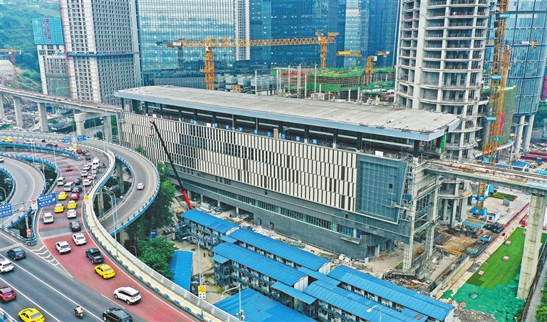
Since 2022, the record has been shattered by Hualongqiao station in Chongqing, China, at 157.5 ft above ground (180% of Smith-9th). The station is on the 6th floor, with an entire shopping center beneath it. Chongqing is also well-known for its extremely hilly terrain (for example, just 2 stops away from this highest station worldwide is Hongyancun station, the deepest in China, 381 ft below ground). However, the "170 ft Eastern Ave station" would have broken the record by 8%. Here's another Video of the river crossing after exiting the station. (Photo source 1, Photo source 2)
2880px-Hualongqiao_Station_202201.jpg

W020210602337829770499.jpg


To be fair, Eastern Ave station faces a somewhat similar situation as Hualongqiao: immediately adjacent to a river crossing. So perhaps it can be justified a bit more. But still... It's absolutely wild.
 
But that brings up another point: Splitting the "Urban Ring" into two along the Eastern Route really isn't a bad thing - it will already be used as such.

If we assume very few riders will go from Assembly all the way to Airport, then the demand pattern along this stretch really serves as two routes:

1704270141249.png


(I excluded Harvard for a simple reason: The cost of building that will likely be nearly the same as fully grade-separating the "Silver Line" here, including a harbor crossing.)

The choice of colors is not a coincidence.
  • "Gold Line" is your standard Urban Ring. As I discussed above, its demand probably ends at Eastern Ave.
  • "Silver Line" is basically today's SL3. As I'll discuss below, "terminating" it at Chelsea probably won't hurt much.
Suppose we build them exactly like this: Gold as LRT (or HRT if you're ambitious), and Silver as BRT. What are you missing out?
1. Everett to Airport (both BL and Logan access)
2. Everett to Seaport and South Station

Now suppose you don't even want SL3 to cross Chelsea Creek, and just terminate it south of the bridge. What else are you missing out on?
3. Chelsea to Airport (both BL and Logan access)
4. Chelsea to Seaport and South Station

You can see how they're very similar problems. #1 and #3 actually have solutions that are potentially much more cost-effective, if not straight up better: the T104 bus in the redesign, which connects Malden, Glendale, downtown Everett, downtown Chelsea, and BL Airport Station. It serves the core density of Everett and Chelsea much better than any station on the Eastern Route, not to mention it serves Malden that the Urban Ring can't hope for. (Chelsea also has another connection to the Blue Line: the T116.)

#4 has another easy and better solution: Extending the T111 bus to Seaport via the Downtown Bus-Priority Corridor in the BNRD, or what @Riverside calls "the Navy Line". It's a corridor connecting North Station to South Station and Seaport (Summer St) for the T7/93 bus, but has the potential to do more; the StreetBlogMass article I linked even mentions the 111. Such an extension benefits even more Chelsea riders - who can now go more directly into downtown than stopping at Haymarket - than SL3. Even the distance to Seaport doesn't differ by much.

#2 can be solved with a similar approach, if we want to: add another bus route from Everett's Broadway to Rutherford Ave and then to the downtown bus corridor. Such a route has not been proposed yet - and Everett residents didn't like a version of SL6 that stops at Haymarket - but it can be introduced if there's demonstrably strong demand from Everett to South Station and Seaport. In fact, such a route would probably stand out more for Everett than it does for Chelsea due to distance advantages.

To summarize: On a closer inspection, the need for a continuous Urban Ring service from Sullivan to Airport - or even that of a better Chelsea Creek crossing for transit - really isn't nearly as high as you may think, and definitely not worth the hassle of building an expensive river crossing.

Plus, treating the "Gold" and "Silver" lines as ending at Chelsea opens up possibilities for interesting, "semi-radial" extensions, like this:
1704270250923.png


This actually has some value. It's one of the cheapest ways to bring rail as close to downtown Revere as possible, with the only other reasonable way likely being a median-running El on Revere Beach Pkwy. Yes, I agree with F-Line that the station has bad walkshed, but it could have been worse. At least it's only a 12-min walk to downtown Revere, not terribly longer than the 9-min walk from Malden Center station to the true Malden Center.

As for the "Silver" Line, if you're feeling really ambitious and managed to build a grade-separated ROW all the way to South Station, you can even extend it to Everett, then via Saugus Branch to Malden Center and further northeast, kinda like Riverside suggested here. (Or, heck, just pave a busway there and extend SL3 as BRT, with a shared BRT/LRT corridor between Chelsea and Everett.)
 
Last edited:
Sullivan - Airport via Grand Junction is about 4.92 miles. Sullivan - State - Airport via OL and BL is 4 miles: that's even shorter!
  • Even people starting their trip at Sullivan may use OL-BL for a faster journey despite the 2SR. For people coming from Wellington, Malden etc heading to Airport (or worse, Wonderland), no way they're getting off at Sullivan.
I don't think people think this way when taking the train, and basically everyone would take the UR from Sullivan to the Airport. People don't think about how many miles the train is going. Nor is it even easy to tell, especially because the system diagram map would likely show the UR route as a roughly straight line from Sullivan to the Airport. And even practically, going an extra mile on a train isn't a big deal. You just sit there a few minutes. Compared to the variable amount of time a transfer adds on, it's basically a wash. Plus the OSR option means no hauling luggage up and down stairs, or trying to get a new seat on the second train. If the UR has nice new, comfortable, reliable trains and stations, then I would expect people would go from Sullivan, Kendall, and Cambridgeport to the airport on the UR rather than whatever transfers. It would be more comfortable and convenient.

Anecdotally, I face this same kind of option whenever I visit DC. I visit people who live off the Blue Line, which goes to the airport on a slightly circuitous route. I know I can shave maybe 10 minutes off the trip to the airport by transferring at some point to the Yellow line. The OSR is far preferable, especially when carrying luggage. I generally don't transfer, unless I'm really crunched for time.
 
Last edited:
I think something that will be 20/20 hindsight in about 15 years from now will be a very densely built up Everett between Encore and through downtown Everett up Broadway, especially along RBP. Right now, RBP and the rest of 16 is car centric, backed up at rush hour and weekends (from Revere to Fresh Pond), being developed in a very dense fashion now (Stop and Shop Redevelopment I'm looking at you), will be transformed through the gas tanks project and Everett is a very dense core with a working class, transit-dependent community, which is probably one of the more YIMBY cities around. If anywhere might be a candidate for needing it badly while building for the future, all MA legislative processes aside, I would think the dense blotch of Everett incoming is a really good one. I am not sure - if we're being crazy - sure, some type of feasible BRT is probably still crazy because of the difficulties of building around 16 and Broadway in Everett - but personally I don't think BRT will catch on enough to help. Personally, in my transit fantasy world, elevated concrete lines would catch on more in Greater Boston like other metro areas.
 
I don't think people think this way when taking the train, and basically everyone would absolutely take the UR from Sullivan to the Airport. People don't think about how many miles the train is going. Nor is it even easy to tell, especially because the system diagram map would likely show the UR route as a roughly straight line from Sullivan to the Airport. And even practically, going an extra mile on a train isn't a big deal. You just sit there a few minutes. Compared to the variable amount of time a transfer adds on, it's basically a wash. Plus the OSR option means no hauling luggage up and down stairs, or trying to get a new seat on the second train. If the UR has nice new, comfortable, reliable trains and stations, then I would expect people would go from Sullivan, Kendall, and Cambridgeport to the airport on the UR rather than whatever transfers. It would be more comfortable and convenient.

Anecdotally, I face this same kind of option whenever I visit DC. I visit people who live off the Blue Line, which goes to the airport on a slightly circuitous route. I know I can shave maybe 10 minutes off the trip to the airport by transferring at some point to the Yellow line. The OSR is far preferable, especially when carrying luggage. I generally don't transfer, unless I'm really crunched for time.
These are some good points. But:
  • There's a lot of dependence on how Logan terminals will be accessed, for both Urban Ring (terminating at Airport BL / stopping at a centralized transit center at Central Parking / stopping at all terminals) and some form of remaining BL-terminals service (either buses or APM).
    • If Urban Ring terminates at Airport BL, which I think is the most realistic, then a lot of its potential advantages to BL (or even T104) are moot.
    • A Central Parking station is still about a 10-min walk from each of the terminals, which can be especially troublesome for people with bags. If it coexists with a door-to-door service, I'm not sure it can be competitive.
    • LRT to all terminals require tracking and wiring of all the airport access roads at terminals, which doesn't sound optimistic especially when we're dealing with Massport, and it also locks the service split in place: even if you build a cross-harbor transit tunnel, it's unlikely that you can afford to make 5 stops between BL and Seaport, so "Gold" and "Silver" lines will still need to be served by different routes.
  • While I can see a greater incentive for someone starting their rapid transit journey at Sullivan or even Kendall (including bus transfers at Sullivan), most people taking OL won't be coming from Sullivan. They'll be from points further north, such as Wellington, Malden, Oak Grove and potentially Reading. For these riders, the OSR vs 2SR difference won't be there (especially if UR doesn't go to all terminals).
  • UR via Chelsea St Bridge also presents a reliability risk due to bridge openings. For someone rushing to the airport to catch a flight, the last thing they want to experience is having the train turn back at Eastern Ave with no way to get across the bridge for 20 minutes or more. In contrast, the Blue Line is always reliable, and the time on transfer at State is much more manageable (and won't even be a negative factor for riders north of Assembly).
  • Even if occasional riders don't measure distance, in practice they do count the number of stops. Urban Ring isn't even very competitive in that sense:
From Airport BL to...Downtown transfer stopsUrban Ring transfer stops (*)
OL Assembly87-9
OL Sullivan78-10
GL E branch (East Somerville)99-11 or N/A (**)
GL D branch (McGrath infill or Union Sq)910-12 or N/A (**)
RL Kendall (***)610-15

* Compulsory intermediate stations (before Sullivan) are Assembly, Encore, Sweetser Circle, and all current SL3 stops. Optional stations are 2nd St, and Wood Island/Eagle Square.
** The first value uses the East Somerville alignment, with an infill at Squires Bridge on the D for transfers to UR. The second value uses the traditional Grand Junction alignment without GLX transfer.
*** Does not assume a Tech Square infill, but assumes Red-Blue without Bowdoin.
**** Compulsory stations (beyond Sullivan) are a station somewhere near Brickbottom (Cambridge St, Twin City Plaza, or Lechmere), and Kendall/Main St itself. Optional stations are another station near Brickbottom (East Somerville, and/or if you want both Twin City Plaza and Cambridge St), and Binney St.
The other thing frequent users are aware of is the convenience of the transfer, particularly with luggage.

Orange to Blue at State is not a great transfer with luggage. At least one direction requires stairs (IIRC). And the station is really spread out.
 

Back
Top