You are using an out of date browser. It may not display this or other websites correctly.
You should upgrade or use an alternative browser.
You should upgrade or use an alternative browser.
Crazy Transit Pitches
- Thread starter BostonUrbEx
- Start date
The EGE
Senior Member
- Joined
- Jun 29, 2013
- Messages
- 1,909
- Reaction score
- 5,282
That's the nature of transit pitches - it's very common for multiple people to independently come up with similar ideas, especially in a 300-plus-page thread! If you look at the very first page of this thread, there are ideas there that we still discuss 15 years later - and there's someone replying to an idea with a century-old map of a similar concept.Great takes. Sorry to anyone if my idea ended up being the same as yours, honestly just really liked that crossrail idea.
That's definitely the direction I've gone as well. This is my personal crayon for that idea, which could more-or-less be cut-and-cover within Logan. You can either do 2 or 3 airport stations; 2 gives you a slightly longer walk to Terminal C but makes the curves easier.This is why my default preference for any cross-harbor tunnel is one that can accommodate light rail trains that serve the front doors of Logan's terminals, just like the Silver Line does today.
Teban54
Senior Member
- Joined
- Nov 13, 2021
- Messages
- 1,142
- Reaction score
- 2,856
Re: South Boston
I was very much surprised by the 15-min walkshed coverages of Broadway and Andrew, given that both stations pretty much have their walksheds limited to one or two quadrants. (15 min still seems a bit too long, but I guess it's decent enough here.)
Dorchester St (to Andrew) and East Broadway west of L St are wider, usually at 60'. That's enough for a reservation, but the less ideal transfer point of Andrew would probably wipe out the time savings.
So I agree with everyone (including @HenryAlan's comment) that an isolated streetcar that ends at Broadway station is definitely not worth it -- even if you can somehow get a reservation, it's better suited for buses/BRT. The value of LRT would lie in through-running beyond the Red Line. Running to the downtown core is ideal, but Copley may be fine, thanks to existing ridership patterns cultivated by the 9 bus.
It's also a fact that Southie residents use buses almost exclusively to travel out of the neighborhood, not within. Quoted from Route 9's Better Bus Report:
(I could have done this analysis for more recent years, but decided not to spend too much time at the moment.)

This is elegant! I agree that if we want rapid transit spacing in particular, then this is probably the most cost-effective way to do it.Employment patterns are the main reason why I think an extension of an LRT Silver Line down to East Broadway makes the most sense. 1SR to Financial District and it's nearest commercial center, Seaport. There's space on Summer St and L St for a reservation, and there are only 5 cross-streets. Additionally, there is a slight incline from 2nd street, potentially making it easier to bury the last leg of the line ( cutting down crossings to 3 and avoiding any interference with Broadway). Another cool aspect of this is that now the entirety of South Boston has a 15-minute walk to a major transit connection.
View attachment 62075View attachment 62076
I was very much surprised by the 15-min walkshed coverages of Broadway and Andrew, given that both stations pretty much have their walksheds limited to one or two quadrants. (15 min still seems a bit too long, but I guess it's decent enough here.)
A streetcar on Broadways is nice, but at this point, I think the benefits of it seem to mostly duplicate the benefits of the existing 9 and 10 for local service. Still stuck in traffic, vulnerable to accidents, and slow speeds. I think a reservation (like what is planned at the end of the E) would be met with fierce opposition. Southie loves their car space and the grid is working against you here with 17 cross-streets between the Red Line and City Point. There would be a lot of uproar about who loses their left or right run onto Broadway and I'm not sure how much faster it would be in the end. Tunnelling would mean it would be a lot less local and a whole lot of money.
Indeed, West Broadway at its narrowest is about 47' wide, or down to 40' at intersections with expanded curbs. While that's theoretically enough for two transit lanes, two travel lanes, and maybe a unidirectional parking lane... It still means a significant reduction in parking. (You may make it work by running on the parallel W Fourth St in one direction, though.)
- Dedicated ROW and speed opportunity:
- Most of Southie's streets are narrow, so even bus lanes are difficult. There are also a lot of intersections. Given that, it seems unlikely that a streetcar would be faster than a bus -- and might actually be slower, given acceleration rates
- Stop spacing:
- Current stop spacing is often every block, typically well-below 1000'; obviously stop consolidation is an option, but given the constrained street space, it seems reasonable to try to spread the load out rather than have larger crowds boarding at fewer stops


Dorchester St (to Andrew) and East Broadway west of L St are wider, usually at 60'. That's enough for a reservation, but the less ideal transfer point of Andrew would probably wipe out the time savings.
So I agree with everyone (including @HenryAlan's comment) that an isolated streetcar that ends at Broadway station is definitely not worth it -- even if you can somehow get a reservation, it's better suited for buses/BRT. The value of LRT would lie in through-running beyond the Red Line. Running to the downtown core is ideal, but Copley may be fine, thanks to existing ridership patterns cultivated by the 9 bus.
It's also a fact that Southie residents use buses almost exclusively to travel out of the neighborhood, not within. Quoted from Route 9's Better Bus Report:
Boardings are high at nearly all nearly all stops on Broadway in South Boston, with most serving over 200 boardings. However, there are very few alightings, indicating that nearly all riders are traveling out of South Boston rather than to other locations in South Boston.
Note that for the 9 bus, the Bus Route Profile states the following for westbound ridership:A few datapoints for consideration:
- Current bus ridership: looking at the 2018 Better Bus Profiles (for ease of reference, gambling that the underlying dynamics haven't shifted post-COVID):
- 7, Summer Street <> South Station (ish): 4,400 daily riders
- 9, E Broadway <> Broadway station <> Copley: 6,400 daily riders
- But note: ~1,000 of these riders board at Broadway, likely transfering from the Red Line to reach destinations in the South End; effective ridership in South Boston proper may be closer to 5,400
- 11, 8th St <> 6th St <> Broadway station <> downtown: 3,000 daily riders
- 800 South Boston riders alight at Broadway (1/3 of all boardings)
- 500 riders board at Broadway, to utilize the Broadway-Copley connection
- South End stops see 160 boardings and 325 alightings
- The Back Bay/Copley stops see 1,300 boardings (40% of all riders)
(I could have done this analysis for more recent years, but decided not to spend too much time at the moment.)
Re: the bolded parts:I think it's also worth noting that, to my knowledge, there has never been a particular push locally for grade-separated rapid transit service in Southie, nor any push to restore a streetcar. (Indeed, some original BERy plans called for El service to Southie, but they were dropped early on.) And I think this largely makes sense; of the reasons to institute a light rail line, not many present a strong case:
[...]
Assuming an LRT conversion of the Silver Line, I would probably look at some way to extend SL2 to City Point, or add a second branch that pops down along Summer St. Yhe original SL3 did poorly due to competition from the 7, but an LRT line would offer a 1SR to Back Bay and either Kenmore or Huntington, so it would probably command greater interest. I like @samsongam's thought process and visualization.
- Integration into a subway:
- Yes, a light rail line could either hook into the subway at Pleasant Street, or could connect at what is now Silver Line Way
- That being said, I don't think there's a hugely urgent need for this kind of integration
- I wonder if the lack of advocacy was because the 7 and 9 buses had never been officially acknowledged as important routes before -- even though they factually are, with over-the-top rush hour frequencies and high-ranking riderships. Also, off-peak frequencies on all Southie buses had moderate to poor compared to rush hours. However, all of this will change with BNRD, where they now have two Frequent Bus Routes with guaranteed 15-min headways off-peak.
- IIRC, the original SL3 failed largely because of terribly roundabout routes. The fact that it had to go to Northern Ave @ Tide St was ridiculous (see the Wikipedia image below). But even if a revived "SL3" LRT only goes to South Station, a better route can still do it wonders.
- I wonder if the lack of an "urgent need for integration" was partly triggered by these historical anecdotes above, and the consequent beliefs that "LRT doesn't work here" or "buses here aren't important enough". But the bases for such beliefs are in question.
Teban54
Senior Member
- Joined
- Nov 13, 2021
- Messages
- 1,142
- Reaction score
- 2,856
That's quite an intriguing idea, even if not the most relevant.Heck, you could even have a second branch into Southie proper, with one going down Summer St (like @samsongam showed) and a second one reclaiming some space for a semi-dedicated ROW along Pappas Way, with about a quarter-mile of running on Dorchester St, into a transit plaza at the intersection with the Broadways:
View attachment 62265
View attachment 62264
But it got me thinking... How about a unidirectional loop that joins these two "branches" together?
I don't think either of these does much for Southie though. Even going via D St "only" shifts the W Broadway station by 2,200 ft, whose walkshed still has plenty of overlap with today's Broadway station.But to me, I think the biggest swing would be serving Southie more centrally by way of a Red Line Realignment to the Seaport, with the new subway hooking down along either D Street or Dorchester St (or Track 61). Topologically, a lot of the subway <> surface connections would remain similar, just relocated east. But the advantage is that x% of Southie would be within the walkshed of a subway line, which certainly would be an upgrade.
View attachment 62266
That being said, I don't think there's a particularly urgent (Southie-based) case for the Red Realignment; to me the primary draw is serving the Seaport -- if you can tack on service to Southie, all the better of course.
You pretty much need to turn at Pappas Way / Dorchester St to go deep into Southie, at which point you're running across the whole Seaport and incurring a significant detour. (Which is why I agree that such a reroute should be primarily about Seaport.)
Teban54
Senior Member
- Joined
- Nov 13, 2021
- Messages
- 1,142
- Reaction score
- 2,856
Logan Airport
F-Line in particular is quite heavily against it, and so were many other members. Not just because of cost, but such an alignment can only be used almost exclusively by the Newburyport/Rockport line. For all other lines, it ranges from bad to impossible. See the link above for more justifications.
LRT Cross-Harbor Tunnel
I agree that any new harbor crossing should be primarily for rapid transit, especially for the Seaport Transitway or something similar.
That said:
I've gone back and forth on this. My current concerns are:
Alternatively, it seems possible to have a centralized "Airport Terminals" station within 800-1,300 ft from all terminals. That seems fine to me, even if a bit longer than ideal.
Having said that... I can probably get by with two intermediate stops, one at terminals A/B and one at C/E.
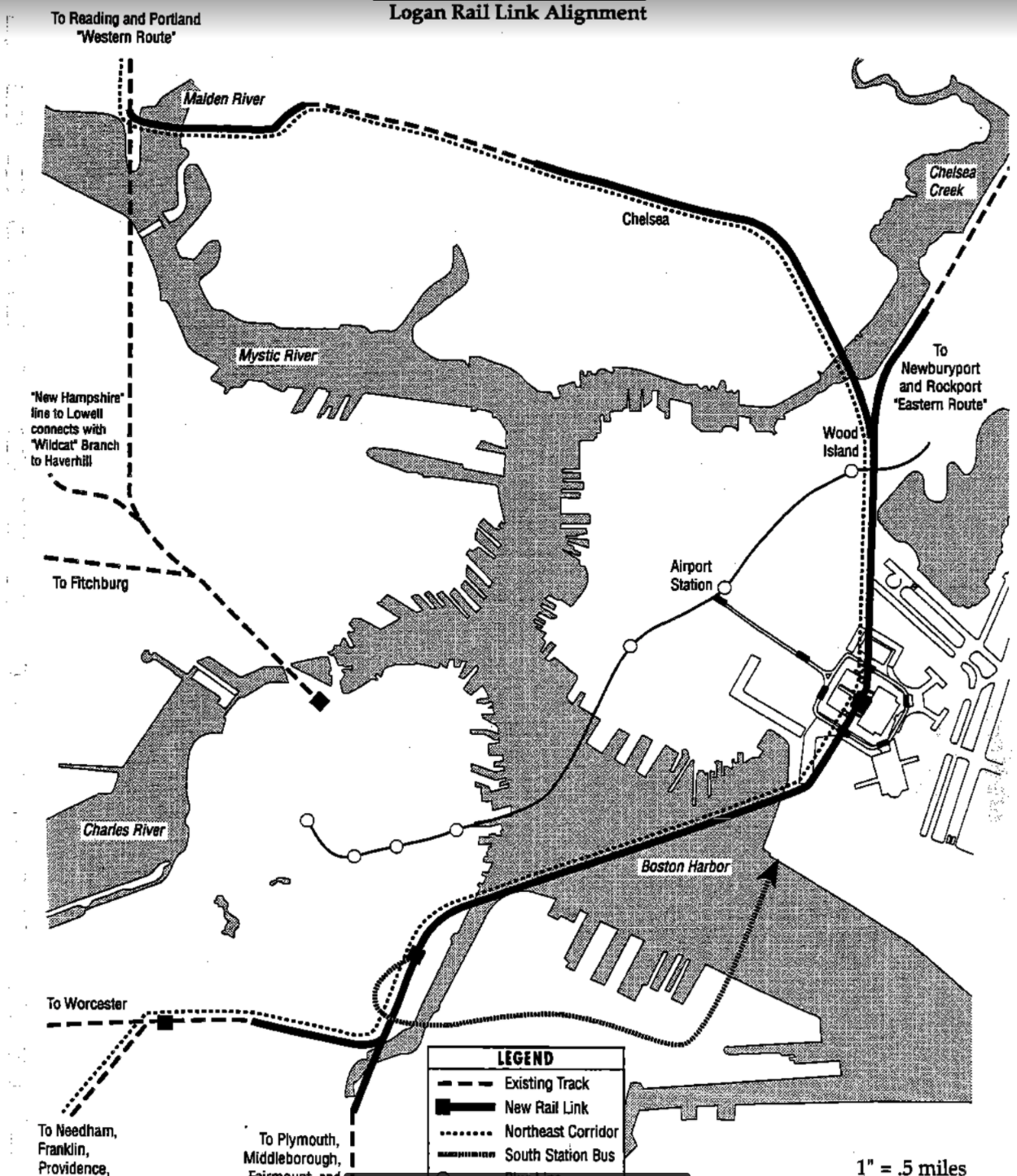
This is more of a question than an actual “idea” I have to share (which is basically me slightly changing that Crossrail idea that was floated a little while back here). My “idea” is basically reusing the original Eastern R.R. ROW to reroute the entire Newburyport/Rockport Line. It would follow the old ROW until it goes behind that truck depot off of 1A. Then it would go underground, with a singular station under Logan (likely located under central parking, with either tunnels to the terminals, or to a connection with an APM), before going under the harbor. It would then curve and go under Summer street, with a station around the convention center. Finally, it would go under South Station (probably around the bus terminal), and connect with the NEC either right before Back Bay, or a little after it.
Throwing the cost aside, is this even logistically possible? Also, would this be too redundant, given it mostly follows the Blue Line? A new station would be made right before the junction in Revere, and an extension of the urban ring from Sullivan to a tunnel under the BL airport station would take over the old tracks. This also would also be paired with the NSRL.
There had been heavy debates about a mainline rail link between South Station and Logan Airport. In fact, there had been an insane real-world study: (link to archBoston discussion)I think that's been proposed on here before, and I know Ari Ofsevit has proposed it. It's certainly not easy - you're talking 4-5 miles of new tunnel, almost entirely under water and filled land - but certainly intriguing.
F-Line in particular is quite heavily against it, and so were many other members. Not just because of cost, but such an alignment can only be used almost exclusively by the Newburyport/Rockport line. For all other lines, it ranges from bad to impossible. See the link above for more justifications.
LRT Cross-Harbor Tunnel
I agree that any new harbor crossing should be primarily for rapid transit, especially for the Seaport Transitway or something similar.
That said:
I know I've said this before, but I think we underappreciate how good the Silver Line actually is. Believe me, it could and should be much better, don't get me wrong. But I think we don't realize how unusual it is to have a curbside 1SR directly into the CBD and to the major transit hub. Most airports with a transit connection require the intermediate use of a people-mover, which connects to a train that then goes to the CBD. SFO, JFK, and Newark are all like this, as will LAX. The only two that I can think of in North America with a direct connection to the terminals are Philadelphia and O'Hare. In Philadelphia, the Airport Line runs half-hourly (why), using 2-car trains running from platforms shorter than the Green Line's; O'Hare is best-in-class, but even there you need a people mover to get to one of the terminals.
This is why my default preference for any cross-harbor tunnel is one that can accommodate light rail trains that serve the front doors of Logan's terminals, just like the Silver Line does today.
That's definitely the direction I've gone as well. This is my personal crayon for that idea, which could more-or-less be cut-and-cover within Logan. You can either do 2 or 3 airport stations; 2 gives you a slightly longer walk to Terminal C but makes the curves easier.
View attachment 62270
I've gone back and forth on this. My current concerns are:
- With multiple stops at airport terminals, trips across Logan Airport become a headache. This includes trips from Blue Line (and Chelsea) to Seaport and South Station, currently served by the SL3.
- The terminals' access roads are very prone to traffic, so street-running LRT destroys reliability and should be immediately out of the question.
- If you're building a new grade-separated route for LRT, that same expense can probably be used to run an APM or moving walkways, either in place of or in addition to the LRT.
Alternatively, it seems possible to have a centralized "Airport Terminals" station within 800-1,300 ft from all terminals. That seems fine to me, even if a bit longer than ideal.
Having said that... I can probably get by with two intermediate stops, one at terminals A/B and one at C/E.
I don't think that's relevant here: ORD's Terminal 5 is entirely out of the way in a different complex, with a straight-line distance of 3,000 ft even from the nearest terminal. Also, their Blue Line passes relatively closely to Terminal 5, just that it's on a curve. If you really want to, you can probably have a Blue Line infill stop there with a walk of ~1,200 ft to the terminal.O'Hare is best-in-class, but even there you need a people mover to get to one of the terminals.
Teban54
Senior Member
- Joined
- Nov 13, 2021
- Messages
- 1,142
- Reaction score
- 2,856
Green Line A branch, where A stands for... Arsenal?

This is a very quick shower thought. But it has a few curious advantages:
This is a very quick shower thought. But it has a few curious advantages:
- Less overlap with the B branch and the 57 bus (which may not necessarily be a pro depending on how you see it)
- Much better ROW availability than the 57 corridor
- B&A ROW likely has room for LRT tracks, even allowing for grade separation
- Arsenal St is wide enough for a dedicated transitway
- Supports developments at Arsenal Mall, Boston Landing, and future West Station
- Challenges the traditional idea that the Arsenal St corridor feeds into Cambridge/RL
astroTrain27
New member
- Joined
- Mar 14, 2024
- Messages
- 27
- Reaction score
- 55
I’d be interested to see what the big names on this thread have to think of this. It’s certainly a little janky, but it makes a surprising about of sense.
I could see this working well as a (hopefully) temporary solution that provides a decent service while land-banking some important corridors and gets the local TOD juices flowing.
I could see this working well as a (hopefully) temporary solution that provides a decent service while land-banking some important corridors and gets the local TOD juices flowing.
Longfellow
Active Member
- Joined
- Dec 12, 2023
- Messages
- 440
- Reaction score
- 1,070
ChatGPT, please tell me the German word for the type of PTSD you get from seeing transit extensions colocated with legacy mainline ROWs
- Joined
- May 25, 2006
- Messages
- 7,069
- Reaction score
- 2,004
Anything that adds more street running is a non-starter. You make some assumptions that aren't really true: Arsenal St really isn't wide enough for a dedicated transitway given its importance as an east-west artery, and neither is the B&A ROW.
So, I have discussed this at length here, as an alternative to a second NSRL tube.I think that's been proposed on here before, and I know Ari Ofsevit has proposed it. It's certainly not easy - you're talking 4-5 miles of new tunnel, almost entirely under water and filled land - but certainly intriguing.
I'm not sure how you get 4-5 miles of tunnel. The ROW is clear until a bit north of Airport Station. It is 1.2 miles from Summer St to Eastie and .6 miles to the southern end of a RR station. That leaves a bit of C&C north
I think that's been proposed on here before, and I know Ari Ofsevit has proposed it. It's certainly not easy - you're talking 4-5 miles of new tunnel, almost entirely under water and filled land - but certainly intriguing.
TheRatmeister
Senior Member
- Joined
- Sep 23, 2023
- Messages
- 1,584
- Reaction score
- 3,212
AlteeisenbahnneuegemachtestressChatGPT, please tell me the German word for the type of PTSD you get from seeing transit extensions colocated with legacy mainline ROWs
TheRatmeister
Senior Member
- Joined
- Sep 23, 2023
- Messages
- 1,584
- Reaction score
- 3,212
I'm honestly not super unhappy with this proposal. If you can link into the NE corridor I really think that could be merit enough by itself as a way to move away from air travel. (IE, someone gets off their Delta flight from Rome or wherever at Logan, then gets on a train to NYC rather than connecting to JFK or LGA.) New York's airports are so inaccessible, not to mention expensive to access in the case of JFK, that that might actually serve as a significant source of demand. Basically if a helicopter shuttle people will pay out the nose for makes sense, surely they'd consider the train from Boston instead of a connection to JFK with a long bus/subway ride at the end. Also amusingly the next post after the one linked is about dedicated transit lanes on Arsenal Street. Time is a flat circle.There had been heavy debates about a mainline rail link between South Station and Logan Airport. In fact, there had been an insane real-world study: (link to archBoston discussion)
F-Line in particular is quite heavily against it, and so were many other members. Not just because of cost, but such an alignment can only be used almost exclusively by the Newburyport/Rockport line. For all other lines, it ranges from bad to impossible. See the link above for more justifications.
Agreed. At 4 ft/s (average walking speed) thats around a 5 minute walk. Not great, but I've definitely seen worse. With moving walkways it's more like 3.5-4 minutes.Alternatively, it seems possible to have a centralized "Airport Terminals" station within 800-1,300 ft from all terminals. That seems fine to me, even if a bit longer than ideal.
TheRatmeister
Senior Member
- Joined
- Sep 23, 2023
- Messages
- 1,584
- Reaction score
- 3,212
Probably wide enough for elevated supports though...Anything that adds more street running is a non-starter. You make some assumptions that aren't really true: Arsenal St really isn't wide enough for a dedicated transitway given its importance as an east-west artery, and neither is the B&A ROW.
It's neither a pro nor con, it's a different route serving different places. The pro is that it serves one place, the con is that it doesn't serve the other place. If the projects aren't mutually exclusive those roughly balance out.Less overlap with the B branch and the 57 bus (which may not necessarily be a pro depending on how you see it)
If you're just a little bit creative you can make it work though. A little single track and creative routing around a couple intersections can get you to Oak Square just fine, which realistically is probably as far as any restoration should go.Much better ROW availability than the 57 corridor
Fixed it for you.Anything that adds more street running is a non-starter. You make some assumptions that aren't really true: *I think Arsenal St really isn't wide enough for a dedicated transitway given its importance as an east-west artery, and neither is the B&A ROW.
Whoever the big names in this thread are, I think Teban54 is definitely one of them.I’d be interested to see what the big names on this thread have to think of this. It’s certainly a little janky, but it makes a surprising about of sense.
")
B&A ROW width: I think the width is totally fine east of Everett Street (Boston Landing station), particuarly assuming 2 of the mainline tracks can be converted. At Boston Landing itself, I agree that the ROW is indeed a little constrained, particularly just west of the station near the switch. But west of the switch, the ROW opens up again with ample space on both sides of the tracks. The mainline tracks would need to be realigned, but that's hardly fatal. And the Pike itself is 8 lanes plus a road shoulder and grass shoulder here, and Lincoln St itself is at grade and has two travel lanes plus parking. I think there are plenty of options along here.
Arsenal St width: The eastern half of Arsenal St is 5-6 lanes. It narrows west of Arsenal Way, but that's also where the old Watertown Branch ROW approaches. Reactivating the ROW, and purchasing four small-to-medium sized buildings plus some stretches of parking lots gets you to Beechwood Ave. At that point, the street has widened again to ~62'; reserving 25' of that for a transitway would still leave ample space for three 10' travel lanes, or two 9' travel and two 9' turning lanes at intersections. I believe the widths here are comparable to the travel + median bus lanes on Columbus Ave. It gradually tightens to 50' approaching Watertown Square, which would constrain the travel lanes to one in each direction. (I also acknowledge that stop platforms would need consideration too.)
Galen St width: Mostly four travel lanes plus parking or bulb-outs on both sides. Given the connection at Boston Landing, I'm not sure I would prioritize extending the light rail this far; I'd probably opt for cumulative bus services to provide high frequency transfers between Newton Corner and Watertown Square/Yard.
Arsenal St as an arterial: this is always a trade-off when reclaiming road space for transit. In this case, Arsenal forms a pretty clear and straightforward linear corridor of higher commerical and (increasingly) residential density. That's exactly the kind of environment that transit thrives in. I have a vague memory (which may be incorrect) that travel times on Columbus Ave have improved for both transit and private vehicles, presumably in part because x automobile trips were able to switch to transit due to improved speed and reliability. A transitway could also benefit the 70 and potentially other routes that might get extended thanks to the increased reliability. A transitway would move more people in and out and through this corridor; if done right, that reduces the importance of an automobile arterial aspect.
North Beacon St: I'm curious, @737900er, why does North Beacon look more appealing to you? The widths seem similar, but are you thinking that traffic volumes would make a median more amenable?
Like @Teban54 said, it would likely be a compromise route, but it hardly seems like a non-starter.
North Beacon St: I'm curious, @737900er, why does North Beacon look more appealing to you? The widths seem similar, but are you thinking that traffic volumes would make a median more amenable?
The biggest thing is running time to Watertown Square, which will always be a major trip driver. If this runs to BU/Kenmore/Copley it would siphon off a lot of traffic from the 57 and 504.
On Arsenal Street there is only so much you can do with TSP. There are over 10 lights on the existing stretch that would be encountered on the existing alignment, in addition to a lot of unprotected lefts. Some of those could maybe be eliminated, but you're still left with major intersections at SFR/Western, Arlington/Coolidge/Forge, and School. At Greenough you might consider building a bridge over the intersection given the adjacent grades. Even if you have full TSP at every intersection, current operating rules require 10mph through all intersections, but this is CTP so we can probably ignore that.
The 70 is sort of a hybrid radial/corridor route that probably has to be run at high frequency in perpetuity or completely replaced with a riverfront LRT.
This is sort of hard to explain, but there is very little "permeability" between the western portions of Arsenal Street and the rest of Watertown, which has more historical connections to the Red Line/Harvard than the Green Line/Kenmore. North Beacon has the same issues, but it would be a lot faster. The UPS Facility, parks, and Buckingham Browne Nichols athletic facility aren't going anywhere either.
WarpedReality
New member
- Joined
- Oct 11, 2013
- Messages
- 45
- Reaction score
- 57
I'm honestly not super unhappy with this proposal. If you can link into the NE corridor I really think that could be merit enough by itself as a way to move away from air travel. (IE, someone gets off their Delta flight from Rome or wherever at Logan, then gets on a train to NYC rather than connecting to JFK or LGA.) New York's airports are so inaccessible, not to mention expensive to access in the case of JFK, that that might actually serve as a significant source of demand. Basically if a helicopter shuttle people will pay out the nose for makes sense, surely they'd consider the train from Boston instead of a connection to JFK with a long bus/subway ride at the end.
Wouldn't improving New York's connections to its own airports be a better solution here? Particularly, extending PATH to Newark Airport seems to be a much more ample opportunity to increase transit access to New Yorkers traveling internationally.
TheRatmeister
Senior Member
- Joined
- Sep 23, 2023
- Messages
- 1,584
- Reaction score
- 3,212
Well, yes NYC airports should have better connections.Wouldn't improving New York's connections to its own airports be a better solution here? Particularly, extending PATH to Newark Airport seems to be a much more ample opportunity to increase transit access to New Yorkers traveling internationally.
But ideally those short flights along the NEC shouldn't be happening at all. Better rail links for NYC area airports also furthers this goal, allowing the same Boston-NYC-Wherever connection but without the domestic flight, or more likely Providence to NYC then wherever.
JeffDowntown
Senior Member
- Joined
- May 28, 2007
- Messages
- 5,075
- Reaction score
- 4,305
To do this you need a real inter-city high speed rail hub at the airport (for example at JFK), like the TGV model at CDG. A multi-transfer rail option on conventional subway (which is very luggage unfriendly) is not going to get people to mode-shift from short hop regional air.Well, yes NYC airports should have better connections.
But ideally those short flights along the NEC shouldn't be happening at all. Better rail links for NYC area airports also furthers this goal, allowing the same Boston-NYC-Wherever connection but without the domestic flight, or more likely Providence to NYC then wherever.
Teban54
Senior Member
- Joined
- Nov 13, 2021
- Messages
- 1,142
- Reaction score
- 2,856
To some extent, we already have this at EWR. (The AirTrain can be annoying, but it's much closer to an actual airport APM than JFK's AirTrain is.)To do this you need a real inter-city high speed rail hub at the airport (for example at JFK), like the TGV model at CDG. A multi-transfer rail option on conventional subway (which is very luggage unfriendly) is not going to get people to mode-shift from short hop regional air.
So I'd say that any rail-to-air passengers along the NEC south of EWR, and possibly south of New Haven-ish, will probably not be too enticed by a hypothetical "Amtrak Logan Airport" station when EWR is an option. The remaining portion closer to Boston probably doesn't have the ridership base to warrant such investment.