You are using an out of date browser. It may not display this or other websites correctly.
You should upgrade or use an alternative browser.
You should upgrade or use an alternative browser.
"Dirty Old Boston"
- Thread starter theSil
- Start date
 Boston
Charlie_mta
Senior Member
- Joined
- Jul 15, 2006
- Messages
- 5,202
- Reaction score
- 7,901
Found these photos of the old Green Line elevated line in the North Station area.
 1906 BOSTON STREET SCENE PHOTO, colorized by Asar Studios
 Boston Court House, 1920, colorized by Asar Studios
Very early 2000's. You can still see the State Street Bank sign in the middle on their older Franklin Street tower. Millennium Place and 111 Huntington are up, but 1 Lincoln is nowhere to be seen. Also, I think the building U/C in center right is the Nine Zero Hotel (still named that?) and not 33 Arch as it looks at first glance. EDIT: Just noticed the elevated highway as well!

Last edited:
atlantaden
Senior Member
- Joined
- May 31, 2006
- Messages
- 2,681
- Reaction score
- 3,356
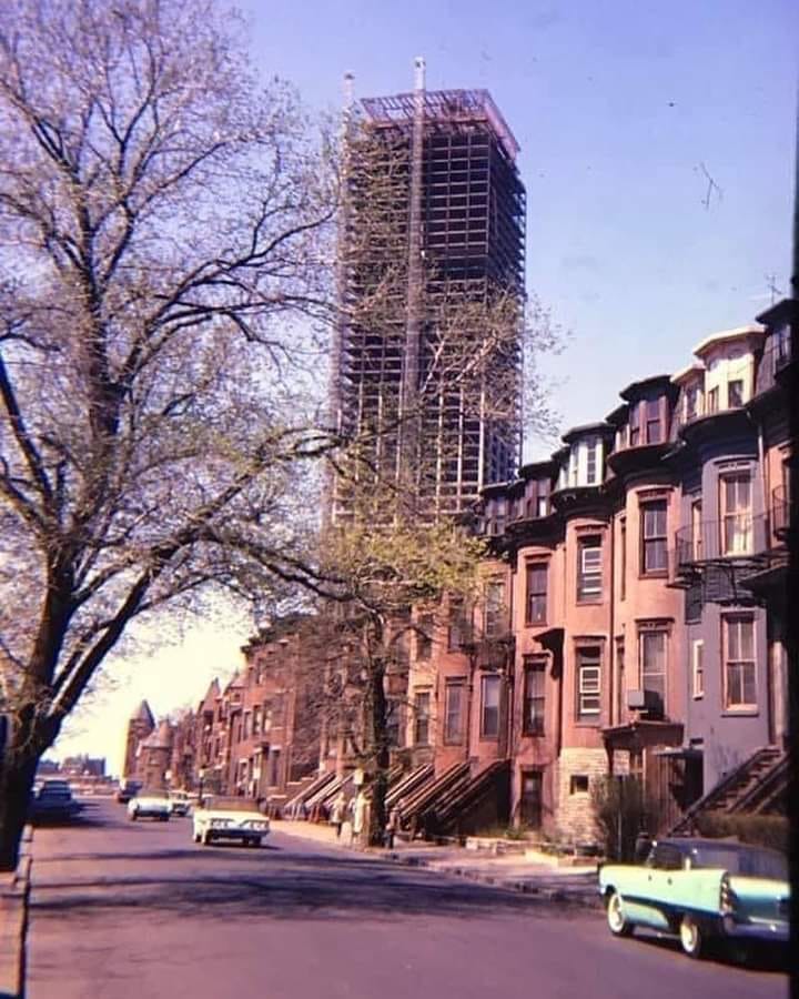 West Newton St Back Bay Boston by clamshack, on Flickr
Charlie_mta
Senior Member
- Joined
- Jul 15, 2006
- Messages
- 5,202
- Reaction score
- 7,901

atlantaden
Senior Member
- Joined
- May 31, 2006
- Messages
- 2,681
- Reaction score
- 3,356
Steeple is lifted by crane to the top of the scaffold enclosed church. The steeple of Boston's Old North Church was seriously damaged by Hurricane Carol on August 31, 1954. The rebuilding of the steeple was a matter of great civic pride in the city. This was the church from which patriots signaled with lanterns to Paul Revere that the British were marching to Concord and Lexington.
Photographer:
(Reed, Verner photo)
TallIsGood
Active Member
- Joined
- May 30, 2006
- Messages
- 546
- Reaction score
- 133
Statler Hilton. Interestingly Sheraton had its HQ downtown on Independence Wharf.
atlantaden
Senior Member
- Joined
- May 31, 2006
- Messages
- 2,681
- Reaction score
- 3,356
Charlie_mta
Senior Member
- Joined
- Jul 15, 2006
- Messages
- 5,202
- Reaction score
- 7,901
Thanks for clarifying the name Statler Hilton. For some reason I had Sheraton Hilton stuck in my mind.Statler Hilton. Interestingly Sheraton had its HQ downtown on Independence Wharf.
Last edited:
atlantaden
Senior Member
- Joined
- May 31, 2006
- Messages
- 2,681
- Reaction score
- 3,356
BeyondRevenue
Active Member
- Joined
- Mar 13, 2020
- Messages
- 553
- Reaction score
- 1,157
For the youngsters or for those who don't know what they're seeing here, this is when the wrecking ball stopped to get a beer and some shutterbug near lower State Street took a snapshot from their soot laden office window.
The actual destruction was so much more vast. This is another answer to the question "why doesn't stuff get done anymore?" and why a generation of Bostonians Will. Not. Trust. The Government. even when they are doing something necessary or good.
This was not fully necessary or good. This was an excuse to put buckets of federal money into a connected private developer's pocket.
At some point that same person could have turned the camera 90 degrees to the right and watched the same thing happed to a good chunk of the North End.
For an idea, the dead buildings on this side of the Charles are shaded...(Cambridge was too fuzzy)
Keep me honest and let me know if I missed any survivors
Keep me honest and let me know if I missed any survivors
I think far left, right over the word "Dirty" but only the section that juts out as far as the "t." Also maybe that section in the very bottom middle?
BeyondRevenue
Active Member
- Joined
- Mar 13, 2020
- Messages
- 553
- Reaction score
- 1,157
I was on the fence about that one.I think far left, right over the word "Dirty" but only the section that juts out as far as the "t." Also maybe that section in the very bottom middle?
I'd say this one is from about 2005-2006 range. It's amazing how much bigger it seems today, especially with a few well placed taller buildings added into the mix.

Plen-T-Pak
Active Member
- Joined
- Jul 23, 2007
- Messages
- 253
- Reaction score
- 490
Seen these pictures of Boston looking like Rotterdam post WW2 countless times, but highlighting all that remains today is really tough to digest, also knowing it still continues today with the demolition of the last buildings of the West End officially planned.For the youngsters or for those who don't know what they're seeing here, this is when the wrecking ball stopped to get a beer and some shutterbug near lower State Street took a snapshot from their soot laden office window.
The actual destruction was so much more vast. This is another answer to the question "why doesn't stuff get done anymore?" and why a generation of Bostonians Will. Not. Trust. The Government. even when they are doing something necessary or good.
This was not fully necessary or good. This was an excuse to put buckets of federal money into a connected private developer's pocket.
At some point that same person could have turned the camera 90 degrees to the right and watched the same thing happed to a good chunk of the North End.
For an idea, the dead buildings on this side of the Charles are shaded...(Cambridge was too fuzzy)
Keep me honest and let me know if I missed any survivors
View attachment 26949
atlantaden
Senior Member
- Joined
- May 31, 2006
- Messages
- 2,681
- Reaction score
- 3,356
Old John, one of my favorite Boston buildings, going up!!
