You are using an out of date browser. It may not display this or other websites correctly.
You should upgrade or use an alternative browser.
You should upgrade or use an alternative browser.
Dorchester Bay City (nee Bayside Expo Ctr.) | Columbia Point
- Thread starter JoeGallows
- Start date
whighlander
Senior Member
- Joined
- Aug 14, 2006
- Messages
- 7,812
- Reaction score
- 647
Throw in the BEAT and you are starting to develop on the scale of Kendall and its on the Red Line to boot
In ten years this could be competing certainly with the GE/Gillette area of South Boston and even competing with Harvard II
In ten years this could be competing certainly with the GE/Gillette area of South Boston and even competing with Harvard II
stick n move
Superstar
- Joined
- Oct 14, 2009
- Messages
- 13,482
- Reaction score
- 24,540
Im seeing a trend in the Boston area that is absolutely the way future cities are going to need to function and its amazing. Im not sure if its a byproduct of lack of space in the core, or if its being strategically done, but this new model of each neighborhood having its own core is absolutely the future. The old model of jobs downtown and housing on the outskirts which leads to horrible traffic, pollution, and 0 walkability or bikeability is going away.
Were seeing new cores going up in Allston yards, Fenway Boylston, Fenwat ctr, JFK/Bayside, Seaport, Broadway, Suffolk downs, Beacon yards, Kenmore, Assembly, Dot ave, Andrew sq, Ruggles, Dudley, South bay, Readville, Ink block... and on and on.
At first it wont lead to massive shifts, but over time people move around and change jobs, and with job and housing cores now scattered all over the Boston metro area people will be either much more likely to live closer to the core they work at, work in the core closer to where they live, or live and work in two areas that are easily accessible to eachother.
For instance I live in Dorchester. Once the Dot ave corridor builds out, the JFK core...etc I will now have a much better chance of being able to work in my own neighborhood than I do now. This means I will now be able to just walk or bike to work. Spread that out to every neighborhood and you have a major shift. Also being on the red line many more cores are going up on the red line as well, giving many more options, leading to a much higher chance I can still commute by train regardless of job changes etc. I think that in 15 years when lots of these cores are starting to get going and hit their stride there is going to be a massive shift in the way the people here live work and commute.
Equilibria
Senior Member
- Joined
- May 6, 2007
- Messages
- 7,229
- Reaction score
- 8,759
The LOI:
The size here is kind of absurd. 4 MSF is half of the Amazon HQ2 request in office space. The overall proposal is about the same residential area as the complete Assembly Square master plan, but with twice the retail and twice the office.
That said, it's less than half the size of Suffolk Downs - the square footage here is the same as what that project has placed in Revere alone. Kind of underlines how beyond enormous that effort is. The difference is that I trust HYM to finish the job.
palindrome
Senior Member
- Joined
- Jun 11, 2006
- Messages
- 2,288
- Reaction score
- 140
Anyone have any idea where Santander is looking to go?
whighlander
Senior Member
- Joined
- Aug 14, 2006
- Messages
- 7,812
- Reaction score
- 647
Palindrome -- saw something today -- Santander has 2,400 people down thereAnyone have any idea where Santander is looking to go?
Mix of back operations and phone support + large floor devoted to IP equipment to run their branches and ATMs
so they need both office and heavy IP -- there are not too many places to go which can support both
They seemed to indicate that they were not planning on moving in the near future
My guess is that they'll take their time evaluating options as a lot of chess pieces move around in the next 5 or so years when the big new spaces under construction come on line.
stellarfun
Senior Member
- Joined
- Dec 28, 2006
- Messages
- 5,726
- Reaction score
- 1,586
Re: Santander.
From the LOI
From the LOI
Currently, the 2 Morrissey Boulevard property is fully leased to a tenant for office, banking and other uses. The 2 Morrissey Boulevard property is anticipated to be redeveloped in a later phase of the proposed project, after the existing tenant’s lease has expired.
Im seeing a trend in the Boston area that is absolutely the way future cities are going to need to function and its amazing. Im not sure if its a byproduct of lack of space in the core, or if its being strategically done, but this new model of each neighborhood having its own core is absolutely the future. The old model of jobs downtown and housing on the outskirts which leads to horrible traffic, pollution, and 0 walkability or bikeability is going away.
Agreed, it is a trend that is happening else where too. I think it is both a outcome of lack of space at the core and being driven by market forces, specifically our changing economy as well as changing physical requirements for manufacturing and logistics. The city developed with distinct industrial/ commercial districts outside of historic fine grained neighborhoods. Often these areas were the most recently reclaim wetlands built long waterways or rail lines. Its a pretty traditional 'model' of the city, for those geography nerds I am thinking about the Hoyt Model shown below.
You can see this pattern pretty clearly via satellite, I highlighted the the "transportation/industry" belts which are clearly visible via their larger scale of buildings (or lack of buildings). These industrial areas are not only largely obsolete for modern industry and logistics, the value of their land and access to transportation is pushing their transition to other uses. I think that is at least partially due to, or at least exacerbated by, the fact that Boston is a dense land constrained city.
I would argue that this is not a new trend either. Kendall has been under going this transition for what 40 years now and one could even argue that Back Bay, Fort Point, and North Station/Bullfinch Triangle where early examples of similar transitions. Though I agree, the scale at which planning and growth is occurring now does seem to be new for Boston and like cities. No doubt driven by global (rather than simply regional) pressure on select core cities to create products, both intellectual and for RE investment.
Fitting this site into the context, I think it is part of that trend. I am excited to see what they are planning.
Im seeing a trend in the Boston area that is absolutely the way future cities are going to need to function and its amazing. Im not sure if its a byproduct of lack of space in the core, or if its being strategically done, but this new model of each neighborhood having its own core is absolutely the future. The old model of jobs downtown and housing on the outskirts which leads to horrible traffic, pollution, and 0 walkability or bikeability is going away.
Exactly. All those orange areas were originally marsh, of course, and then were filled in for RRs etc. Now theyre available for redevelopment. (Should incude the Pru area in that btw).
I like that it's an archipelago of mini-cores that's a mirror image of the original archipelago of terra firma in the estuary
I decided to highlight the areas which are now being to transition rather than those which have already transitioned, but totally. I could have also tossed in MIT too.Exactly. All those orange areas were originally marsh, of course, and then were filled in for RRs etc. Now theyre available for redevelopment. (Should incude the Pru area in that btw).
I like that it's an archipelago of mini-cores that's a mirror image of the original archipelago of terra firma in the estuary
whighlander
Senior Member
- Joined
- Aug 14, 2006
- Messages
- 7,812
- Reaction score
- 647
Goody -- this is not -- repeat not a new phenomenon for BostonAgreed, it is a trend that is happening else where too. I think it is both a outcome of lack of space at the core and being driven by market forces, specifically our changing economy as well as changing physical requirements for manufacturing and logistics. The city developed with distinct industrial/ commercial districts outside of historic fine grained neighborhoods. Often these areas were the most recently reclaim wetlands built long waterways or rail lines. Its a pretty traditional 'model' of the city, for those geography nerds I am thinking about the Hoyt Model shown below.
You can see this pattern pretty clearly via satellite, I highlighted the the "transportation/industry" belts which are clearly visible via their larger scale of buildings (or lack of buildings). These industrial areas are not only largely obsolete for modern industry and logistics, the value of their land and access to transportation is pushing their transition to other uses. I think that is at least partially due to, or at least exacerbated by, the fact that Boston is a dense land constrained city.
I would argue that this is not a new trend either. Kendall has been under going this transition for what 40 years now and one could even argue that Back Bay, Fort Point, and North Station/Bullfinch Triangle where early examples of similar transitions. Though I agree, the scale at which planning and growth is occurring now does seem to be new for Boston and like cities. No doubt driven by global (rather than simply regional) pressure on select core cities to create products, both intellectual and for RE investment.
Fitting this site into the context, I think it is part of that trend. I am excited to see what they are planning.
View attachment 4127
View attachment 4128
It began in the 1600's -- it even has a name in Boston's History -- it was called Wharfing-out back then and for the next couple of hundred years
The best thing to do is go to the BPL and the Norman B Leventhal Map Center --- where there is a tremendous collection of maps and related stuff covering this process
Norman B. Leventhal Map & Education Center
Show Menu: Service Areas and Spaces Service Areas & Spaces Welcome Center Borrower Services Children's Library Community Learning…
 www.bpl.org

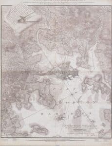
This map from the Norman B Leventhal Collection
shows Boston proper, Charlestown, South Boston and East Boston : showing original territory of old Boston, the areas filled and reclaimed from tide water and the areas available for future reclamation .. port of Boston
Creator: Boston (Mass.). City surveyor.
Creator: Geo. H. Walker & Co
Date: 1894
or you can get the following book from Amazon:
In any case -- Boston began as a good harbor and some small amount of solid land some flat at near sea level and some hilly [i.e. Beacon Hill, Copps Hill, Pemberton Hill]. First the Bostonians built wharfs out into the Harbor with some warehouses on the wharfs [e.g. Long Wharf] then they built houses near the wharfs. Then the filling began between the shore and the shallows in the Harbor. The wharfs were extended and the process repeated [eventually Long Wharf extened almost 1/2 mile into the harbor and became King / State St. on land. Meanwhile new houses and soon businesses where built on the new fill. Old houses built in the previous cycle were repurposed or the land was taken for other higher values uses.
Classic example is what happened to the Boston version of the Chicago or Fort Worth Stockyards. In Brighton the cattle drives from places like Concord came to an end. The cattle where slaughtered and the cattlemen had some places to stay. Eventually this went away and the land became houses, light industry and such. Now its being repurposed yet again as a place for sports teams and other related activities.
Brighton Allston Cattle Industry: Stockyards and Abattoir
Brighton Cattle Industry
The Brighton Cattle Market, was founded in mid-1776 when Jonathan Winship I and II, father and son, put out a call to the farmers of Middlesex county urging them to slaughter their cattle and send the resulting meat supply to the village of Little Cambridge (later renamed Brighton) to help provision General Washington's soldiers. The British had just evacuated Boston, and the Army of New England, then headquartered in and around the liberated city, was in desperate need of provisions of all kinds. The Winship family, who held a contract from the U.S. government to supply meat for the army, soon realized, that there more money to be made from doing the slaughtering themselves, which, of course, necessitated the establishment of a local slaughterhouse.
The cattle and slaughtering trades, launched in 1776, quickly transformed the sleepy agricultural village of Little Cambridge into a thriving commercial center. The selling and butchering of cattle became the economic mainstay of the town for more than a century, profoundly influencing virtually every aspect of Brighton's economic, political, and social development.
Same process occurred in the mud flats of South Boston [under water at high tide] which after filling in mid 1800's, became rail yards and warehouses and today are the site of the Federal Courthouse and Vertex Pharmaceuticals, etc.
One result of the process is that even in the core of Boston Proper things changed so much -- that there are buildings with curved facades [one on a corner curves on both adjacent faces] despite the fact that the once curving streets have long since been straightened and widened.
Goody -- this is not -- repeat not a new phenomenon for Boston
It began in the 1600's -- it even has a name in Boston's History -- it was called Wharfing-out back then and for the next couple of hundred years
The best thing to do is go to the BPL and the Norman B Leventhal Map Center --- where there is a tremendous collection of maps and related stuff covering this process
Norman B. Leventhal Map & Education Center
Show Menu: Service Areas and Spaces Service Areas & Spaces Welcome Center Borrower Services Children's Library Community Learning…
or you can get the following book from Amazon:
Gaining Ground: A History of Landmaking in Boston - By Nancy S. Seasholes
Of course I own that book, what sort of geography nerd do you think I am? I did say this wasn't a new trend but I don’t think this is simply wharfing out either.
While I agree these phenomena are related, in that they are both phases of city growth, I also think the areas I highlighted and the process Stick and others are observing is very distinct from wharfing out and land reclamation in Boston generally. The main distinctions to me are the scale of development, land use types and their transition.
Much of that wharfing out was done during the pedestrian and rail city eras. It was dense, fine grained, and contiguous with existing urban fabric and uses. Generally speaking however, the areas of interest for this discussion, are those which were reclaimed later. These areas are generally less centralized and or did not confirm to the scale of existing urban fabric. As you note, they were stock and rail yards, warehouses and many other industrial areas. Which I think is the first thing that makes these areas a specific case from wharfing out generally, these areas are large in scale and mainly industrial use, in contrast to the fine grained abutting fabrics. I would not describe them as pedestrian orientated areas, many were "transit orientated” but for distribution of goods and not people, another distinction from older more centralized wharfing out. In other words, they are not the Downtown Waterfront, the majority of Back Bay or Southend. [1]
The other key difference is the transition of land use. Wharfing out wasn't transitioning land use so much as making new land to build on. It was less a change in the economy and need for new urban forms and more a sign of the scarcity of land on which to build. What we are seeing now is that established urbanized areas of the city are transitioning land use from one use and form to significantly different uses and denser forms. This too is surely related to land being scarce however what is different is this transformation is happening in these areas for political and economic changes what are happening now.
The old industrial buildings being replaced are obsolete for modern industry while the Boston economy is being driven by jobs in bio tech, tech, insurance, and finance. These growth industries require different urban forms and the growing workforce requires more housing. Old industrial forms on the decline, new industries on the rise, it becomes a battle of who can pay more. But in additional to the simple economics pushing this transition the development process is very different from the past. Residents now maintain much more power over planning and more engagement in the political process which is keeping growth, partially of large scale, out of fine grained residential areas leaving precious few areas for growth to be accommodated.
The result as Stick noted is going to mark a new phase in Boston and like cities’ urban growth and form, one which I think is worth calling out from those forms of the past such as wharfing out.
[1] I do also think a case can be made that the Prudential Center, North Station/Bullfinch, and Fortpoint were early examples of similar transitions. To be honest, my knowledge of the latter two is pretty limited so perhaps not on those two.
Equilibria
Senior Member
- Joined
- May 6, 2007
- Messages
- 7,229
- Reaction score
- 8,759
Renamed (poorly, IMO) to "Dorchester Bay City".
PNF:
Renders - So... the Seaport, basically:


PNF:


Renders - So... the Seaport, basically:
It looks like they plan to go a bit taller than the Seaport. Page 44 shows one of the towers close to the FAA line, which is about 350' in that area. So it looks like the J Parcel will be pushing 350' and the G Parcel pushing 300'. Visually, considering how many buildings we have in the 200'-299' range, anything over 300' really stands out in the neighborhoods.
I applaud that they are willing to push up to the FAA limits, at least as a peak to the area. I wish neighborhoods with much higher FAA limits, like Kendall, North Point, and to a lesser extent Fenway/Longwood, would also be willing to push their limits *somewhere* in their neighborhoods. North Point is capping at 250' with a 1000' FAA allowance, while this neighborhood in an even more far-flung area is pushing above 300'. Drives me nuts.
Overall I am happy with the first iteration of this plan and hope they don't cut the taller buildings or otherwise reduce the potential urban impact.
North Shore
Active Member
- Joined
- Aug 19, 2014
- Messages
- 263
- Reaction score
- 352
Renamed (poorly, IMO) to "Dorchester Bay City".
PNF:
Renders - So... the Seaport, basically:
View attachment 7284
View attachment 7287
I'll admit that I'm still pissed off because of how Bob Kraft botched the opportunity way back when to acquire this property for a potential Revs stadium and subsequent mixed use buildout.
But any renders that do not address K-circle, even at this preliminary phase, represents a missed opportunity.
kingofsheeba
Senior Member
- Joined
- Aug 22, 2013
- Messages
- 1,099
- Reaction score
- 1,432
Plot Twist: Kraft was never actually aiming for the Bayside Expo site and was playing 4D chess with the BTU.I'll admit that I'm still pissed off because of how Bob Kraft botched the opportunity way back when to acquire this property for a potential Revs stadium and subsequent mixed use buildout.
Double Plot Twist: Kraft already has secretly secured a site in Boston for the Revs but is being extra discreet about it.
Triple Plot Twist: I was listening to Felger and Mazz yesterday and Murray reminded us that Gillette was getting up there and that they seemed to hint that Kraft could tear down Rockland Trust Pavillon (Harbor Lights) and build a new Gillette there. Obviously a rumor but still...
- Joined
- May 25, 2006
- Messages
- 7,064
- Reaction score
- 1,990
But any renders that do not address K-circle, even at this preliminary phase, represents a missed opportunity.
Boston has given up on changing its poorly designed suburban roads. Melnea Cass Blvd is another one which has created a terrible structure for new development. The BRA seemingly gave up years ago.
BosDevelop
Senior Member
- Joined
- Jul 25, 2006
- Messages
- 1,536
- Reaction score
- 399
Kraft could tear down Rockland Trust Pavillon (Harbor Lights) and build a new Gillette there. Obviously a rumor but still...
Zero chance. Site is not big enough. Even downtown, you need parking. People like to tailgate. Bar hoping is not the same.
Suffolk 83
Senior Member
- Joined
- Nov 14, 2007
- Messages
- 3,024
- Reaction score
- 2,512
Lol so theyre just going to completely ignore the Savin Hill neighbor's concerns and all the traffic concerns around the rotary?
Boston has given up on changing its poorly designed suburban roads. Melnea Cass Blvd is another one which has created a terrible structure for new development. The BRA seemingly gave up years ago.
Isn't there already plans to eliminate Day Blvd (and address the circle) as part of the climate resiliency plan?