Elevated Rail: Boston and Beyond

if boston ever builds new elevated railways they will have to be single pier. The memory of the wasteland under the central artery will not be going away anytime soon.

I've been thinking about this. In my rough skecth for Comm Ave a multiuse path fits under the el with a two pier configuation. A single pier would just create dead space. See charlieMTA's picture of the Seattle el - the space underneath the single pier structure is virtually unusable and barren.
 
I've been thinking about this. In my rough skecth for Comm Ave a multiuse path fits under the el with a two pier configuation. A single pier would just create dead space. See charlieMTA's picture of the Seattle el - the space underneath the single pier structure is virtually unusable and barren.

Note that Boston already has a multi-use path under the green line, by lechmere.

Ive never heard anyone say they think the elevated section of the green line is ugly or obtrusive. It actually highlights the water.
 
I've been thinking about this. In my rough skecth for Comm Ave a multiuse path fits under the el with a two pier configuation. A single pier would just create dead space. See charlieMTA's picture of the Seattle el - the space underneath the single pier structure is virtually unusable and barren.

Amen. An el line "elevates" (pun intended) the surrounding environment only when the space underneath is used. It's not an accident that the areas around the single-pier el in Seattle depicted above look dead (and when you see the elevated lines leading out to SEA-TAC airport, it's certainly a stretch to say that they are objectively nice-looking or improve / "urbanify" the environment). Similarly, look at the photo from Queens above. The surrounding area is dead.

It's not an accident that the areas immediately surrounding many elevated rail lines in New York -- the 7 line in Queens, the D/N/F/B/Q (can't remember if all of them are elevated) in Brooklyn, the 4 and Metro-North in Harlem -- and even the El in Chicago's Loop deaden streetlife around them or, if they're on a busy corridor (as in Chicago and parts of Brooklyn), depress the surrounding real estate while not deadening it (in layman's speech, the streets tend to be skeezy).

In a word, I get (and recall) the noir-ish glamour of elevated subways. However, as was the case with the Central Artery, under an elevated highway or subway, you most often have a perpetually dark, trash-strewn deadzone that's either covered in crabgrass or paved. These areas -- in part because the infrastructure overhead is not always impeccably maintained, tends to drip, etc. -- don't work out very well -- they divide one side of the street from the other visually and in terms of pedestrian movement, and people aren't inclined to spend much time underneath them. This is especially true if the el is dull concrete rather than stone/steel, which at least tends to have more aesthetic appeal.

The most successful integrations of elevated rail (or road) and surrounding city that I've seen all have built out the area under the rail (road). Without turning the areas under the elevated transit into stores, cafes, bars, offices or whatever else, elevated rail leaves a black mark on a street, in my experience.

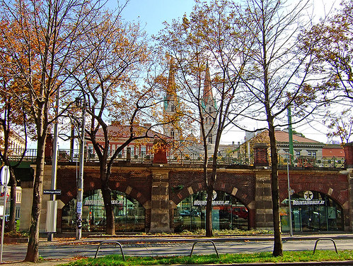
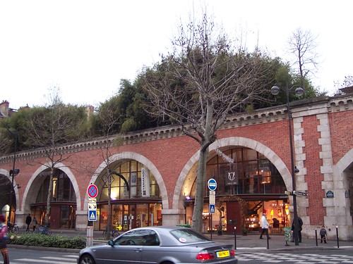
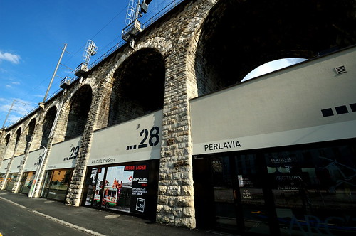
A few examples of success:

Vienna:

1710687591_910859b728.jpg


Paris:

2160258055_808b38097f.jpg


Zurich:

4521453768_56f6523bc1.jpg


New York (Queensboro Bridge):

218805814_4b1c97d0e6.jpg


One thing these all have in common is that they are all in pre-war structures that therefore were built according to classical methods featuring graceful arches, stone, iron/steel, etc. I don't know if building infrastructure this successful, or at least this aesthetically appealing, would even be possible in today's world of value engineering; cheap, pre-fab materials; and pared-down (and ugly) Modernism. My guess is not.
 
Great analysis, Itchy. I agree that building out retail under the trusses of these structures can really add to the built environment. This is especially true, of course, when the structure is situated alongside a road, or in the median of a very wide street such as Queens Blvd. However, when running down the median of a relatively "normal" avenue - I'm thinking Comm or Blue Hill Aves for example - I would think the structure should be as open and airy as possible. I can be convinced otherwise, but I haven't actually seen a median-running El with built-out retail before.
 
if the prefab concrete section construction is relatively easy to maintain and can be affordable, and is used on highway construction, would it be conceivable to use it for BRT? For instance would installing an elevated busway above Washington street solve alot of our issues with the Silverline there?
 
In a word, I get (and recall) the noir-ish glamour of elevated subways. However, as was the case with the Central Artery, under an elevated highway or subway, you most often have a perpetually dark, trash-strewn deadzone that's either covered in crabgrass or paved.

This plays into the ever present "good grit/bad grit" discussion. I think for the most part the Central Artery fell under the category of bad grit if only due to it shear size and location, but it had its moments when it just felt like a truly urban space (much more than the current Greenway). Whereas the el by the Garden was just the opposite. It almost always felt like a cool urban space (good grit) while only occasionally seeming truly dangerous or scary.
 
if the prefab concrete section construction is relatively easy to maintain and can be affordable, and is used on highway construction, would it be conceivable to use it for BRT? For instance would installing an elevated busway above Washington street solve alot of our issues with the Silverline there?

It would require to be wider than a light rail elevated, and the Washington St people would never, never go for it. They wanted rail replacement, not a bus, and putting a bus up on an elevated, no matter how aesthetically tolerable, just wouldn't fly, IMO.
 
It would require to be wider than a light rail elevated, and the Washington St people would never, never go for it. They wanted rail replacement, not a bus, and putting a bus up on an elevated, no matter how aesthetically tolerable, just wouldn't fly, IMO.

Not only does it have to be wider, but it's slower not having a fixed guideway.

BRT's best applications tend to be of the Comm. Ave. reservation variety: road separations w/grade crossings and traffic lights, with maybe a Packard's Corner like split or two where a regular bus route forks off. Or...works best on grade separations at a super-center node like Ottawa's Transitway where the buses loop then fan out in all directions. But once you get into total linear grade separation territory, it gets diminishing results vs. cost of rail designed for more or less same purpose. An end-to-end BRT El may even cost more because of the extra width and speed compromises.
 
I guess when the Green Line to Sommerville and Medford is done there wont even be much of the original and quite venerable Lechemere Viaduct left (i.e. everything between Science Park and North Station is new as will apparently all of the track from the Bridge to the new Lechemere Station)

I wonder if the existing bridge could be converted into a pedestrian bridge of some sort. That would help with the pedestrian crossing issue.
 
I agree with F-L, and just want to add that despite how elegant the examples are (and I love their classic beauty) people just don't spend the money to build like that anymore. It's all precast or poured Commie blocks. This gets me into a granola-bar green peace hippie tanget about building ugly shit that's torn down in 40 years versus good looking stuff that lasts for 120 years but whatever.
 
There are at least 15 miles of routes I've identified where elevated rail could be constructed on wide streets or railroad right-of-ways, providing needed rapid transit service to under-served areas:

http://maps.google.com/maps/ms?msid...0&ll=42.339514,-71.100769&spn=0.134753,0.3368

That A-line route you sketch out is exactly what BERy was going for with their plans to extend out the subway from Kenmore. They saw it going up North Beacon, then joining the Worcester Line (back when it was 4-track) and branching one to Riverside and one (with a little more subwaying down Galen) to the Watertown Branch and Waltham/Arlington Heights.

I wouldn't el it, though. Comm Ave. is one of the few places in town where a subway is doable without torture because it's simply cutting-and-covering an existing ROW that does not have a maze of utility lines underneath it. Fork underground at a flying junction underneath BU Academy for one line onto the Grand Junction for Urban Ring LRT service + Harvard Branch, then send the B back up to the surface at Pleasant St. I think that is the literal only way they can do UR Phase III--loopback thru Kenmore onto the D/Brookline Village to catch the Longwood area--because the billion-dollar tunnel through Brookline is such a fantastical nonstarter it never should've made it to napkin sketch stage on the original design.

From there you could do other service patterns like Watertown by prying some space next to the Pike or Worcester Line. It's not impossible or terribly expensive with a few feet of shifting and taking of grassy embankments. Watertown Branch from the Malls east to the Fitchburg Line is (and pending to be) landbanked to the Fitchburg Line and Porter. The Square has some encroachment that'll take redeveloping the crud industrial lots to pry open some new space.

I would NOT hold my breath on any of those ROW's because of the trail, but the rest of what you sketch pretty much is the only logical option for a modified UR Phase III. But as a subway, not El.


Washington St...definitely that's the prime route fit for a narrow-profile El. Dudley's too critical a route to work on 50-year levels with an at-grade solution--BRT or street-running LRT--and the underground utilities are a nonstarter for a subway. They should've repurposed the old El as a Green Line branch off the Boylston tunnel for exactly this same purpose and simply demolished it past Dudley. Then over span of many years, jack up the structure on trucks underneath while service is running and replace every steel bent--bent-by-bent--with single concrete columns to remake the structure on a lower profile and open up the street underneath. They could've done it bit by bit, stop-and-go, for however many decades and as low a pain threshold as they wanted. Then you could've had the fast grade-separated route to the transfer node and very easy jump-off point for doing a reservation-running B-line like trolley down Blue Hill Ave. to Mattapan. As is, the 28X would've required a bus-to-bus transfer at Dudley because it's simply too much street-running to get there all the way from downtown.

Can't have that bad decision back, but this is the one route for beyond-2030 where it does make sense to at minimum sniff around the idea. The UR is going to throw so much extra connecting traffic through Dudley that the lack of grade separation to/from downtown on the Silver Line is going to become a really vexing, intractable long-term problem. Still think there's gonna have to be no one alive who remembers the Central Artery, but there will be a need on this corridor by mid-century to put every build solution on the study table. We certainly know Washington can handle an El.
 
There are at least 15 miles of routes I've identified where elevated rail could be constructed on wide streets or railroad right-of-ways, providing needed rapid transit service to under-served areas:

http://maps.google.com/maps/ms?msid...0&ll=42.339514,-71.100769&spn=0.134753,0.3368

For the Waltham line, to avoid the central subway, it could take the Grand Junction right-of-way from the BU area and end up at Kendall. Then it could join the Red Line and go to South Station or it could become elevated over quickly developing 3rd St and go to Lechmere/Community College and then over orange line tracks to North Station.
 
Another route that makes sense is Columbia Road. You could branch off the Red Line, and run it all the way to Blue Hill Ave, then up to Mattapan. Alternatively, it appears that the Fairmont Row might be wide enough from Columbia Road outward to accommodate quad tracking, so the El. could switch to that route as an option.. The density for that corridor is very high, far higher than appropriate for the current bus only option, and the street is plenty wide.
 
There are at least 15 miles of routes I've identified where elevated rail could be constructed on wide streets or railroad right-of-ways, providing needed rapid transit service to under-served areas:

http://maps.google.com/maps/ms?msid...0&ll=42.339514,-71.100769&spn=0.134753,0.3368

You show an elevated OL branch running down Route 16 and onto the GC alignment to Chelsea center. Wouldn't Chelsea be better served by a BL branch on the grade-separated ROW that takes it over the Chelsea Street bridge, abandoned ROW with room for an EL for the short distance over Eastern Ave and Cottage St, Bellingham St is grade separated on top of the ROW (stop hereabouts in the residential neighborhood) and then already grade separated the rest of the short distance into Chelsea Station?

Somehow I have a feeling that a BL extension to Chelsea along these lines would be cheaper than a Lynn expansion, generate similar if not greater new ridership, and has equal value in terms of social justice... and yet it doesn't seem like anyone is advocating for it?

That's Urban Ring, which ought to be a Green Line branch. The new maintenance yard has lead tracks that shoot it right on a trajectory to Sullivan and branching off onto the Eastern Route. Intentional setup with their choice of yard sites. So that's going to be far and away the easier line to take out to Chelsea.

Blue ultimately needs to be saved for Salem once it gets to Lynn. That's where the crush-load North Shore ridership truly is. Can't be underestimated how important getting to the Lynn bus terminal is for setting the North Shore transit table. Almost nothing else matters--any extension, anywhere--if they don't do this one.
 
Blue ultimately needs to be saved for Salem once it gets to Lynn. That's where the crush-load North Shore ridership truly is. Can't be underestimated how important getting to the Lynn bus terminal is for setting the North Shore transit table. Almost nothing else matters--any extension, anywhere--if they don't do this one.

But realistically, we're only going to get $2 billion commuter rail extensions that will collect an average of 1,000 daily riders from random, far-flung suburbs.
 
That's Urban Ring, which ought to be a Green Line branch. The new maintenance yard has lead tracks that shoot it right on a trajectory to Sullivan and branching off onto the Eastern Route.

I don't understand that, though - the line between Sullivan and Chelsea station doesn't serve or pass through populated areas of Everett or Chelsea, except for the wrong side of the Broadway/Rt 16 rotary.
 
There are at least 15 miles of routes I've identified where elevated rail could be constructed on wide streets or railroad right-of-ways, providing needed rapid transit service to under-served areas:

http://maps.google.com/maps/ms?msid...0&ll=42.339514,-71.100769&spn=0.134753,0.3368

IMO the best area for elevated railway is Mattapan Station to Dudley Station connection via Blue Hill Ave, Seaver St, Washington St. (Maybe the turn is too sharp for the Seaver St to Washington St. connection). This line would pass through heavily used or frequented areas (i.e. Grove Hall, Franklin Park Zoo, a couple of YMCAs and Boys Clubs, High Schools, Night Clubs, etc.)

I proposed this to the MBTA a few years ago and I received a response, like, they are looking into all ways to improve transportation along Blue Hill Ave.
 
Re: Green Line to Medford to start in 2011

T threads and the Rose Kennedy Greenway thread all seem to go off on an elevated rail tangent so let's have one place to get it all out. Anything elevated trains, in Boston's past or future, or in other cities.

To get things started here is a great archive of pictures of the old Washington St El.

Link

075959pr.jpg


075964pr.jpg


075972pr.jpg

I just found this colorized video-stills of the old Orange Line elevated. I appologize for their annoying loud intro. If you have speakers turn them down.

https://www.youtube.com/watch?v=a9CboN_aZ_Q
 

Back
Top