Equal or Better: The Story of the Silver Line

Ahh, thank you. I couldn't figure out the angle even after looking at it for about an hour.

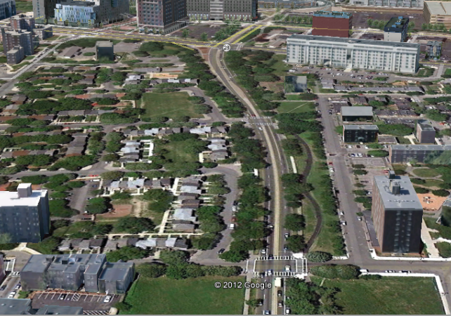
Here's an approximate view of that park today, looking north up Melnea Cass Boulevard. Northeastern is at the top, Madison Park is to the left, and the South End to the right, Frederick Douglass Square area.

madison2.png
 
Hey, did the silver line on washington get painted red as it was supposed to last year?
 
A few interesting insights (at least for me) after watching the film - the perspective of the feds that they were not going to provide $$ for light rail since they had just recently paid to relocate the orange line a few blocks away. The feds probably could care less that the new orange line corridor happened to be less conveniently located to the traditional business and residential districts.

Also, the dichotomy between the S. End. and Roxbury. Roxbury residents were seeking more of an express type service with few stops in the S. End akin to the old elevated whereas the S. End arguably benefited from the Silver Line's more densely located stops in their neighborhood.

Unfortunately, with the silver line, both neighborhoods lost direct connection to the larger subway system
 
I benefited from seeing Washington Street's actual width compared with that of Huntington where the T runs in a median. Huntington is narrower.

With street space now permanently assigned to "rapid" transit (the bus lanes) a light rail conversion should see very little resistance even from the car-set. Logistically, bringing light rail through the Tremont Street subway and turning at Park would not as I understand it erode the capacity of the central subway at all, since Boylston-Park is 4-tracked.
 
That is somewhat misleading. When Salvucci says they would have needed to take land it's because the city would never agree to build street running light rail. Anything built would have to be built along a median which would require a wider street. The area along Huntington that he measures does not have the median and because of this it's misleading. If he had measured the area past Brigham Circle you would see Huntington Ave is wider.
 
the city would never agree to build street running light rail

Therein lies the problem. You could build a reservation from the Cathedral to Melnea Cass but there would be street running at both ends unless they decided to dig some tunnels. While that would make some sense on the north end if money wasn't an issue it would be absolutely stupid on the south end.

Did Flynn have as much of a problem with street running as Menino?
 
... the city would never agree to build street running light rail. ...

Why exactly is that? Why doesn't Boston consider building street running light rail any more? Would their concerns be mitigated if the trolley had its own lane (ie. a repurposed BRT lane)? Is it mayor-specific, as TMcLaughlin suggests?
 
Last edited:
Therein lies the problem. You could build a reservation from the Cathedral to Melnea Cass but there would be street running at both ends unless they decided to dig some tunnels. While that would make some sense on the north end if money wasn't an issue it would be absolutely stupid on the south end.

Did Flynn have as much of a problem with street running as Menino?

I don't understand why it would be stupid to tunnel under Washington Street? To me, street level seems more stupid if you ever intend to have people cross the street without going over train tracks, and is also a huge obstacle to prepaid boardings.
 
Why not just close that narrowest part of Washington Street to cars and make it a trolley-only (or for that matter, Silver Line bus-only) reservation? There are several parallel streets that cars can use instead.
 
Why not just close that narrowest part of Washington Street to cars and make it a trolley-only (or for that matter, Silver Line bus-only) reservation? There are several parallel streets that cars can use instead.

Well, if you're going to close any part of a road that's already in existence, I (and many others, I'm sure) want more than a bus in exchange.

You could shut it down for surface-level tracks, but that doesn't solve the pedestrian crossing problem.

I still don't understand what the problem with burying a Silver Line Light Rail is. The tunnel to connect SL rail Waterfront and Washington is still right there, ready to go, no ten-digit investment needed. Running tracks out to the Pavilion shouldn't be hard with most of that infrastructure primed for conversion already anyway - the only real obstacle is rail down Washington, and almost all of the objections to THAT vanish instantly once you make the committment to getting the hell out of surface level.

And once we get rail back at Dudley, we can have a serious conversation about, say, F-Line (heh) or Silver Line through Roxbury Crossing to Brigham, and maybe on past Brigham to connect to D and C line service.

We could go another direction, too, past Dudley back to Forest Hills and down to Hyde Park, leaving the Orange Line free to be extended to West Roxbury and not having to try and negotiate a routing to Hyde Park via Roslindale.

Hell, do both and fork the line. Let the C-D-E connecting branch of the Silver Line run to the airport, and have the other branch be Hyde Park-Waterfront.

But none of that can happen until we acknowledge that the bus can't and shouldn't be fixed, and we need to throw it away before doing anything else.
 
Enlightening doc. After seeing this, it's hard to really swear up and down about the Silver Line as opposed to blaming the confluence of interests way back in the 70s who were so eager to see the El come down and were happy to accept the SW Corridor Orange Line alignment. Twas the root of all evil?
 
Interesting also about the OL realignment is that it didn't just spell the end of Washington Street/Dudley Rapid Transit but also E-line Arborway, in a way splitting the difference between the corridors. So in a way it's a trade-off: more fast and efficient rapid transit between neighborhoods or slower streetcars directly through them?
 
In the end it's a just trade off. Personally I think we should bring streetcars back but in the grand scheme of things the MBTA did the best it could given the financial realities.
 
CBS, I think the issue with new cut-and-cover tunneling through that part of Boston is the utilities beneath the street. Costs would balloon if they needed to be moved. You could deep bore farther beneath the city-scape as the Red Line did between Porter and Davis, but that has massive financial ramifications of its own.
 
Interesting also about the OL realignment is that it didn't just spell the end of Washington Street/Dudley Rapid Transit but also E-line Arborway, in a way splitting the difference between the corridors. So in a way it's a trade-off: more fast and efficient rapid transit between neighborhoods or slower streetcars directly through them?

Along those lines I was thinking yesterday, that the Arborway and Washington Street El, along with the Fairmount line and the Red line, make for a fairly even spacing of rapid transit service throughout Roxbury/Dorchester. I don't know if that was intentional, or whether it just happened naturally. Moving the Orange line to the SW Corridor ruined that spacing, and since Fairmount has been neglected, that just leaves the huge gap.
 
^ Agreed; this is not just a tradeoff; it ruined the transit equilibrium of the city both in terms of spacing and the extent to which transit is convenient to the densest / busiest parts of neighborhoods.

Maybe if there had been a concentrated effort to develop densely along the SW Corridor the situation would make more sense, but as is there hasn't been a realignment and no one living below the MassPike is as well served by transit as they were pre-1975.
 
CBS, I think the issue with new cut-and-cover tunneling through that part of Boston is the utilities beneath the street. Costs would balloon if they needed to be moved. You could deep bore farther beneath the city-scape as the Red Line did between Porter and Davis, but that has massive financial ramifications of its own.

We should at least be able to get a cost analysis on either of these options instead of saying "nope, can't be done, next!"

Personally, I don't think cut-and-cover would turn out to be that expensive (comparatively), but I'm more than happy to acknowledge being totally wrong if that's what the fact finding results in us discovering.
 
^ I agree, it's a shame that we can't even get a cost estimate study. I'd love to get more tunneling going in Boston, especially outside of downtown where it's easier to do so.
 
We should at least be able to get a cost analysis on either of these options instead of saying "nope, can't be done, next!"

Personally, I don't think cut-and-cover would turn out to be that expensive (comparatively), but I'm more than happy to acknowledge being totally wrong if that's what the fact finding results in us discovering.

Not what I'm saying. I'd like them to tunnel the whole damn thing but such a short tunnel under a congested street? Go ahead and do the cost analysis but it won't happen. Well, unless it's in Hingham.
 
But why tunnel at all? If you have redundant streets, all going the same direction, make some of them for cars, others for transit only.
 

Back
Top