Fantasy T maps

Riverside - I liked the idea of swapping the Mass Ave and Dartmouth Street lines, so did that in the latest of my working map. :)

Also went a little crazy with reworking more of the "Green Line" system in Cambridge and Somerville to bring back more of the lost streetcar network in those cities. Added in some other cross-town options for Everett and Chelsea, too.

Most of the new letter lines would be street-running or at-grade, except for areas where streets would be too narrow or the transitions would require some sort of grade separation. The idea of such a dense network would be to modernize street infrastructure (smart signals to start) and minimize single-occupancy vehicle traffic along the corridors. Haven't decided how exactly to do this without making the map appear too busy, but I'll play around with maybe a white line "cutting" the route line in half.

View attachment 60184
Love it.

A note: Clarendon Hill and Alewife Brook Parkway are switched. In fact, you are probably better off doing away with the Alewife Brook Parkway stop altogether. It's less than 300 ft from the Clarendon Hill Busway, while the next two stops' spacing on the C-Branch are 1,900 ft and 4,000 ft each. Allen St and Cleveland St are the highest ridership stops between Arlington Center and Clarendon Hill, so Arlington Center -> Allen St -> Cleveland St -> Clarendon Hill -> Teele would hit higher ridership stops and have much more consistent stop spacing. FOod for thought.
 
The length and lack of people making the full trip given the availability of the Fairmount Line as an alternative make running the line all the way to Mattapan not an appealing option from an operations perspective. However, running it to Franklin Park would make sense as that area is not very accessible via the Fairmount Line, so more people would be taking the line all the way to Downtown.
I was actually thinking more along the lines of local trips. If one of the goals is to reduce car traffic wholesale, having a single seat trip along the entire corridor would be appealing especially if the tracks already exist. Why create a forced transfer instead of ridership options when we know that redundancy begets operational stability. That said, Franklin Park seems like a good compromise because it no longer forces a transfer on 28x corridor where they have no other realistic option of getting to Downtown.
I assume you mean better serve the Aqua Line? The Yellow Line is the Chelsea subway. The rationale is that it's a 1SR to both Longwood and Kendall, which combined, to my knowledge, are roughly equal in terms of jobs to Downtown. Building anything in Downtown is insanely difficult because there's just nowhere to work, so the 'easy' option seems more appealing here. There's still a lot of additional capacity to be had on the Orange Line in the future as well, probably around 2x the current service plus gains from walk-through trains, so the transfer burden should be manageable. The busway can also be used to mitigate this by actually using it in a way that's well suited for buses, running feeder services across Chelsea, Revere, and Everett onto the busway for a fast trip to Airport. A ramp connecting the busway to Broadway would be very useful for this.
No, I meant the Yellow line. I'm surprised that you're not also using the Grand junction through Everett and Chelsea for its own line (which I would make Yellow) and then have a completely separate Chelsea line that goes into Downtown using the Congress street Alignment that was studied for N/S or moves something else (the Medford Branch?) over to a Lomasney/New Chardon/Bowdoin/ Comm Ave alignment that can take over the idea of the curved Blue line idea. So back bay would be Blue on the river, a new or redirected line on Comm Ave, the Boylston Street Subway, Stuart Street, OL, Washington St, and the RL.
Agganis is really not close to BU Central, it's around .6 miles as the crow flies or more like .75 miles on the ground, around 15 minutes walking. And BU West wasn't cast into the shadow realm, it was replaced by Amory St which is basically right where BU West was, just on the other side of Amory St.
So it's like the Amory/Babcock Street equivalent? That makes sense. Visually, I would just have the Aqua line come down with the yellow and then turn up because Pink crossing the river is super distracting.
For the most part, just next to it. At the station itself you've got around 80ft of width available which is enough for 48ft of track and then 30ft of platform. It would need to come at the expense of some amount of parking however.
I guess my question should be more broad. We don't even have dual tracks at Waltham Center but your map envisions this as a junction and then quad tracked. I've always envisioned the chemistry line as terminating at Waltham center, tunneling under Main street, or heading north because that one specific area between Waltham and B/R is so tight. I'm just surprised because that seems like a tough ask but at the same time such a "simple" solution that just makes sense. When we talk here about Green line to Waltham, we usually just move the commuter rail to the Mass Central ROW.
I've actually re-changed my mind on West Medford since then, as someone pointed out it is wide enough for an island GL platform and at least one passing CR track. But in terms of why not further, because the ridership is really bad. Most of the land around Grove St is either cemetary or water, neither particularly likely to be developed in the future, apart from maybe some fish condos. (Unfortunately however due to the usual lack of water in trains, this service does not serve those very well.) Wedgemere is a little better but even if it's ridership doubled with the Green Line, somethiing I'd view as unlikely looking at the surroundings, that's still only ~600 pax per day. However, if the alternative is just closing Wedgemere, maybe it would make sense. That just leaves Winchester Center, where it would be possible to take over the parking lot for a GL station. I can't imagine we're looking at more than 1,500 new daily riders for the segment north of West Medford, and I just don't see a way for the costs to possibly be low enough to make that value proposition work, especially with #80 bus service feeding into Whittemore (Arlington Center) station, and with the possibility for new local routes to feed into Winchester Center.
That's the appeal though: it's a state park and Just like Oak Grove connects people to the Fells, and Forest Hills is just a bus hub next to a park with less density, it's okay to have some stations that serve not much else but access to natural Amenities. For example, why include a Fuchsia line stop at Mt Auburn cemetery if it would just be faster to send people past it? In a way, you're applying this convention elsewhere but you've just deemed the Mystic lakes regionally unimportant because you don't find them important, if that makes sense. Wegemere could certainly be cut but it also works like an Eliot or Waban station that allows local travel, has more of the Mystic Lakes access, and also creates political support for an extension (Green line station or close it).

F-Line actually thought that the Winchester station should be a subway if the GLX ever went there instead of expanding the viaduct or ground level. For me, it makes sense to set up Winchester center as the staging area for a Woburn extension and/or a Stonham extension via the tri-community greenway. Regardless, this extension is certainly not a priority beyond West Medford if that is able to be a transfer station, but it's also not a complete waste.
 
I guess my question should be more broad. We don't even have dual tracks at Waltham Center but your map envisions this as a junction and then quad tracked. I've always envisioned the chemistry line as terminating at Waltham center, tunneling under Main street, or heading north because that one specific area between Waltham and B/R is so tight. I'm just surprised because that seems like a tough ask but at the same time such a "simple" solution that just makes sense. When we talk here about Green line to Waltham, we usually just move the commuter rail to the Mass Central ROW.
Any station at Waltham Center would need to be bi-level, with the Aqua Line platforms underground. This would be one of the most, if not the most, expensive parts per distance, with Watertown Sq close behind.
Just like Oak Grove connects people to the Fells, and Forest Hills is just a bus hub next to a park with less density
Oak Grove isn't built to serve the fells, and Forest Hills isn't built to serve the arboretum. The former is a park-and-ride that was as far north as the OL could get without crossing into Melrose, the latter is the natural convergence of Washington St, the Northeast Corridor, Hyde Park Ave, and several other important corridors. I would argue that any green spaces they serve is a simply a nice coincidence.
For example, why include a Fuchsia line stop at Mt Auburn cemetery if it would just be faster to send people past it?
Mt Auburn St @ Homer Ave is the third busiest stop on the 71, not counting Harvard obviously. (Behind Kimball Rd and Watertown Sq.) There are surrounding condos, and the Star Market site presents an opportunity to build more higher density housing in the area.
 
I've been working on a new "completionist" transit map with an eye to reasonable affordability inspired by much of the conversations on this forum. I tried to fit as much detail into it as I could and as many relevant/connecting forms of transit as possible. Stylistically, I know that the parks/buses/landmarks can be a bit overkill and busy for a strictly transit map, but I prefer these sorts of maps. When thinking about what parks/landmarks to include I thought of it from the perspective of what locations would a visitor to the city be more inclined to visit.


gigaMBTA 2.01x.png

View attachment gigaMBTA 2.0x2.png
I've laid out the real world overlay here along with areas of development that are planned/allowed through things like MBTA communities act and Squares + Streets.

https://www.google.com/maps/d/u/1/edit?mid=1xtyeQI-uKZIKleT7ASXFvRDAPOsctug&usp=sharing

I used an assumption of significant TOD in many of these areas to justify some of the more controversial Indigo Line infills (Crescent Beach, Revere, Faneuil, Union Square). I also included a zone system, accompanied with integrated fares between Subway, Light Rail, and Regional Rail. I personally really enjoy flat fares on the MBTA but given that tap out seems necessary to facilitate free walking transfers (Galileo to Kendall for example), the zonal system seems like an obvious feature to ease connections at this scale.
 
Last edited:
Really like the map and Google Maps overlay. Special points for use of "Whopperton".

Could the Silver Line light rail in Southie loop back around to JFK or Andrew, effectively being a Red Line bypass that allows clockwise/southerly service?
 
Thanks! I'd love to Whop Weston up.

I suppose it's possible to extend the light rail further, it's an interesting idea that I hadn't considered, but I think there are too many problems with it to be really worthwhile.

For one, the tunnels would be really difficult and expensive. Due to the wideness and soft incline on L St., a shallow cut and cover tunnel constructed in phases seems possible for an ending stretch between 2nd and 5th Street ( between the First St. and East Broadway stops on the map) without being too expensive or causing mass disruption. However, going further underground than Emerson St. seems a lot more difficult because L narrows down so much more.

Secondly, I feel skeptical about what the benefits would be. The only place that I can see ROW is maybe an elevated or something in the median area of Columbia Rd. but then you're missing out on a lot of ridership because it runs along the beach and the park. This route seems way too out of the way and slow at this point to be any sort of valuable bypass compared to just going to South Station and catching the Red or OC lines (Indigo 4 on my map). I also don't know if there is a lot of demand from Telegraph Hill or City Point to go to locations immediately South (there are no bus lines here that connect to JFK). Maybe demand would change more with a built-out Dorchester Bay City but the most I can see that warranting is a bus line.
What about looping your Silver Line Light Rail back to West Broadway via Broadway? Broadway really serves the core of Southie. Also there is an abandoned trolley station level in the Broadway Station that could potentially be reopened.
 
Also there is an abandoned trolley station level in the Broadway Station that could potentially be reopened.
Partially demolished for the new fare lobby unfortunately, so not really in a position to be reused. The portals are also in really terrible places, one on Foundry St and one filled in under Dorchester Ave, not on Broadway. Reusing it is probably more trouble than it's worth. At that point it probably makes more sense to extend it along Traveller St to Washington St and the Pleasant St Portal.

To be honest, I'm not that concerned about West Broadway specifically. A rapid transit station at Dorchester St @ East Broadway leaves no section of West Broadway further than a 10 minute walk away from rapid transit. (And that's why my preferred Urban Ring routing stops there.)
 
I've been working on a new "completionist" transit map with an eye to reasonable affordability inspired by much of the conversations on this forum. I tried to fit as much detail into it as I could and as many relevant/connecting forms of transit as possible. Stylistically, I know that the parks/buses/landmarks can be a bit overkill and busy for a strictly transit map, but I prefer these sorts of maps. When thinking about what parks/landmarks to include I thought of it from the perspective of what locations would a visitor to the city be more inclined to visit.


View attachment 61171
View attachment 61170
I've laid out the real world overlay here along with areas of development that are planned/allowed through things like MBTA communities act and Squares + Streets.

https://www.google.com/maps/d/u/1/edit?mid=1xtyeQI-uKZIKleT7ASXFvRDAPOsctug&usp=sharing

I used an assumption of significant TOD in many of these areas to justify some of the more controversial Indigo Line infills (Crescent Beach, Revere, Faneuil, Union Square). I also included a zone system, accompanied with integrated fares between Subway, Light Rail, and Regional Rail. I personally really enjoy flat fares on the MBTA but given that tap out seems necessary to facilitate free walking transfers (Galileo to Kendall for example), the zonal system seems like an obvious feature to ease connections at this scale.
That's awesome!

One thing that stands out to me is the Green Line branch out of North Station towards Charlestown and Chelsea. Has anyone (official or otherwise) sketched out how that would work? The junction at North Station seems hard because this is all under the Garden, the Hub on Causeway, and other existing infrastructure. Crossing the river in your diagram would be ....? Under the Orange, over the NSRL, dodging the Zakim bridge towers? Maybe there's some obvious route I'm missing, but that looks tricky.
 
I've been working on a new "completionist" transit map with an eye to reasonable affordability inspired by much of the conversations on this forum. I tried to fit as much detail into it as I could and as many relevant/connecting forms of transit as possible. Stylistically, I know that the parks/buses/landmarks can be a bit overkill and busy for a strictly transit map, but I prefer these sorts of maps. When thinking about what parks/landmarks to include I thought of it from the perspective of what locations would a visitor to the city be more inclined to visit.


View attachment 61171
View attachment 61170
I've laid out the real world overlay here along with areas of development that are planned/allowed through things like MBTA communities act and Squares + Streets.

https://www.google.com/maps/d/u/1/edit?mid=1xtyeQI-uKZIKleT7ASXFvRDAPOsctug&usp=sharing

I used an assumption of significant TOD in many of these areas to justify some of the more controversial Indigo Line infills (Crescent Beach, Revere, Faneuil, Union Square). I also included a zone system, accompanied with integrated fares between Subway, Light Rail, and Regional Rail. I personally really enjoy flat fares on the MBTA but given that tap out seems necessary to facilitate free walking transfers (Galileo to Kendall for example), the zonal system seems like an obvious feature to ease connections at this scale.
Looks amazing! The more I look, the more I see. Great stuff, top to bottom.
 
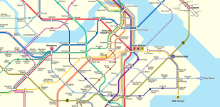
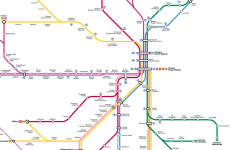
Made some further refinements to my map and wanted to share the central portion (still working through the suburbs and making the map legend).
  • Light rail is now a slimmer line and any street-running portions are distinguished by a black or white stripe along the line.
  • Added small line identifiers where lines split off a shared trunk route.
  • Regional rail lines that terminate at South Station are the F (Middleborough/Lakeville line that continues to the Cape), along with the two special/seasonal services: X (game day trips to Gillette Stadium) and Y (Cape Flyer to Hyannis).
  • Rearranged the South Boston routes and added a local street-running line along D Street that connects into Silver Line Way... and it felt like the eastern communities needed another option to cross the harbor, so the line continues to East Boston, Chelsea, and Everett.
Have nearly finished with my RER design as well. There must be a timeline where something like this is reality, right? ;)
 

Attachments

  • Screenshot 2025-04-12 at 8.33.58 PM.png
    Screenshot 2025-04-12 at 8.33.58 PM.png
    900.8 KB · Views: 126
  • Screenshot 2025-04-12 at 8.38.04 PM.png
    Screenshot 2025-04-12 at 8.38.04 PM.png
    448.8 KB · Views: 99
^ This continues to be more and more delightful at every reveal.
Light rail is now a slimmer line and any street-running portions are distinguished by a black or white stripe along the line.
This definitely does add a lot of clarity around your vision, though I admit that part of me was charmed by the possibility of all of the lines being grade-separated heavy rail!
Added small line identifiers where lines split off a shared trunk route.
This is a clever innovation, I really like it.
Regional rail lines that terminate at South Station are the F (Middleborough/Lakeville line that continues to the Cape), along with the two special/seasonal services: X (game day trips to Gillette Stadium) and Y (Cape Flyer to Hyannis).
FWIW, I think a special service like game day trips could be satisfactorily indicated with some sort of icon next to the station names, similar to how the T indicates Amtrak services:

1745182392616.png

Rearranged the South Boston routes and added a local street-running line along D Street that connects into Silver Line Way... and it felt like the eastern communities needed another option to cross the harbor, so the line continues to East Boston, Chelsea, and Everett.
You might dip into the Crazy Transit Pitches thread, where there's some discussion of rail transit in South Boston.

I think I've said this before, but I'm a big fan of renaming Government Center to City Hall -- the current name is a mouthful, and hard to label on a map!

I like the convention you're using on the RER map of including the city/town name -- "Somerville Powderhouse Square", "Boston Columbia", etc. It's good disambiguation.

Looking forward to seeing more!
 

Back
Top