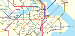
The length and lack of people making the full trip given the availability of the Fairmount Line as an alternative make running the line all the way to Mattapan not an appealing option from an operations perspective. However, running it to Franklin Park would make sense as that area is not very accessible via the Fairmount Line, so more people would be taking the line all the way to Downtown.
I was actually thinking more along the lines of local trips. If one of the goals is to reduce car traffic wholesale, having a single seat trip along the entire corridor would be appealing especially if the tracks already exist. Why create a forced transfer instead of ridership options when we know that redundancy begets operational stability. That said, Franklin Park seems like a good compromise because it no longer forces a transfer on 28x corridor where they have no other realistic option of getting to Downtown.
I assume you mean better serve the Aqua Line? The Yellow Line is the Chelsea subway. The rationale is that it's a 1SR to both Longwood and Kendall, which combined, to my knowledge, are roughly equal in terms of jobs to Downtown. Building anything in Downtown is insanely difficult because there's just nowhere to work, so the 'easy' option seems more appealing here. There's still a lot of additional capacity to be had on the Orange Line in the future as well, probably around 2x the current service plus gains from walk-through trains, so the transfer burden should be manageable. The busway can also be used to mitigate this by actually using it in a way that's well suited for buses, running feeder services across Chelsea, Revere, and Everett onto the busway for a fast trip to Airport. A ramp connecting the busway to Broadway would be very useful for this.
No, I meant the Yellow line. I'm surprised that you're not also using the Grand junction through Everett and Chelsea for its own line (which I would make Yellow) and then have a completely separate Chelsea line that goes into Downtown using the Congress street Alignment that was studied for N/S or moves something else (the Medford Branch?) over to a Lomasney/New Chardon/Bowdoin/ Comm Ave alignment that can take over the idea of the curved Blue line idea. So back bay would be Blue on the river, a new or redirected line on Comm Ave, the Boylston Street Subway, Stuart Street, OL, Washington St, and the RL.
Agganis is really not close to BU Central, it's around .6 miles as the crow flies or more like .75 miles on the ground, around 15 minutes walking. And BU West wasn't cast into the shadow realm, it was replaced by Amory St which is basically right where BU West was, just on the other side of Amory St.
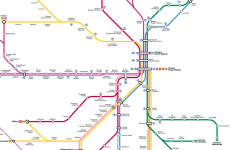
So it's like the Amory/Babcock Street equivalent? That makes sense. Visually, I would just have the Aqua line come down with the yellow and then turn up because Pink crossing the river is super distracting.
For the most part, just next to it. At the station itself you've got around 80ft of width available which is enough for 48ft of track and then 30ft of platform. It would need to come at the expense of some amount of parking however.
I guess my question should be more broad. We don't even have dual tracks at Waltham Center but your map envisions this as a junction and then quad tracked. I've always envisioned the chemistry line as terminating at Waltham center, tunneling under Main street, or heading north because that one specific area between Waltham and B/R is so tight. I'm just surprised because that seems like a tough ask but at the same time such a "simple" solution that just makes sense. When we talk here about Green line to Waltham, we usually just move the commuter rail to the Mass Central ROW.
I've actually re-changed my mind on West Medford since then, as someone pointed out it is wide enough for an island GL platform and at least one passing CR track. But in terms of why not further, because the ridership is really bad. Most of the land around Grove St is either cemetary or water, neither particularly likely to be developed in the future, apart from maybe some fish condos. (Unfortunately however due to the usual lack of water in trains, this service does not serve those very well.) Wedgemere is a little better but even if it's ridership doubled with the Green Line, somethiing I'd view as unlikely looking at the surroundings, that's still only ~600 pax per day. However, if the alternative is just closing Wedgemere, maybe it would make sense. That just leaves Winchester Center, where it would be possible to take over the parking lot for a GL station. I can't imagine we're looking at more than 1,500 new daily riders for the segment north of West Medford, and I just don't see a way for the costs to possibly be low enough to make that value proposition work, especially with #80 bus service feeding into Whittemore (Arlington Center) station, and with the possibility for new local routes to feed into Winchester Center.
That's the appeal though: it's a state park and Just like Oak Grove connects people to the Fells, and Forest Hills is just a bus hub next to a park with less density, it's okay to have some stations that serve not much else but access to natural Amenities. For example, why include a Fuchsia line stop at Mt Auburn cemetery if it would just be faster to send people past it? In a way, you're applying this convention elsewhere but you've just deemed the Mystic lakes regionally unimportant because you don't find them important, if that makes sense. Wegemere could certainly be cut but it also works like an Eliot or Waban station that allows local travel, has more of the Mystic Lakes access, and also creates political support for an extension (Green line station or close it).
F-Line actually thought that the Winchester station should be a subway if the GLX ever went there instead of expanding the viaduct or ground level. For me, it makes sense to set up Winchester center as the staging area for a Woburn extension and/or a Stonham extension via the tri-community greenway. Regardless, this extension is certainly not a priority beyond West Medford if that is able to be a transfer station, but it's also not a complete waste.
")