General Boston Discussion

stick n move

Superstar
Joined
Oct 14, 2009
Messages
11,139
Reaction score
15,155
Where something else does not fit feel free to post in here. This is a thread where you don't have to worry about staying on topic because the topic is the city itself. Its not an open thread but anything about the city itself can go here as this is in the Architecture and Urbanism section of the forum.

Ill start it off with just something to consider. This is what across the river on both sides of Downtown Boston will look like in the not so far off future.
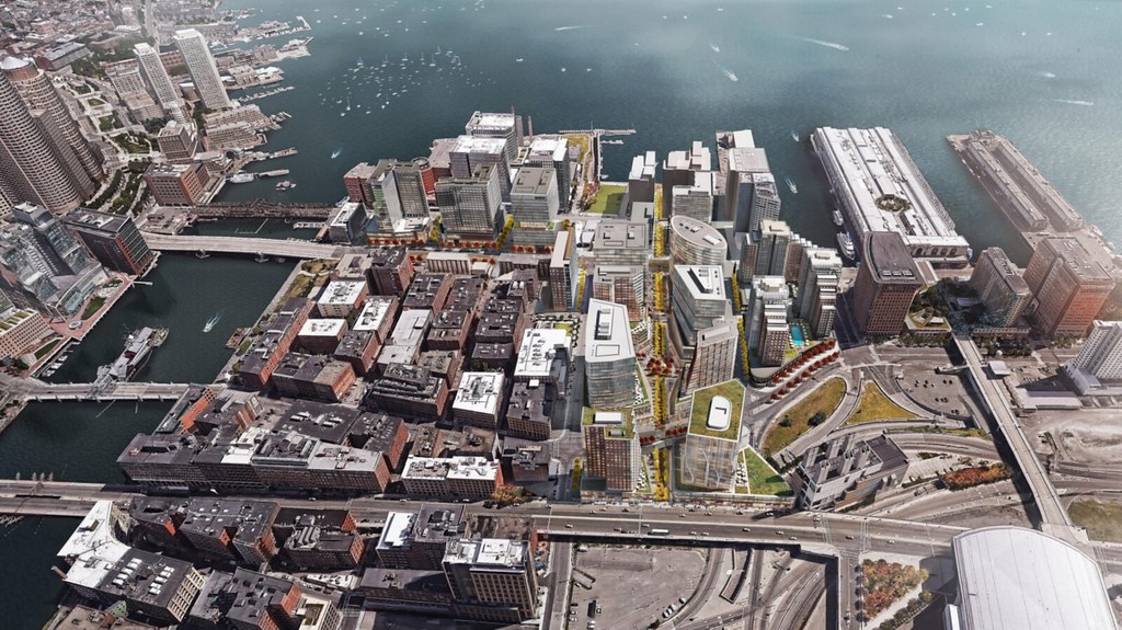
https://flic.kr/p/RKMcd1 by https://www.flickr.com/photos/139261813@N06/

HYM_NorthPoint_Aerial_FINAL+(Clean).jpg
 
I like the repeating buildings on the bottom right corner of the second picture.
 
You're missing Avalon North Station, the TD garden towers, Millennium Tower, Congress Garage tower.
 
Northpoint: Wow they really need another bridge across the tracks because that is a LOT of sq ftge to put onto McGrath / Craigie...

And to the original discussion starter - yeah amazing to think that these were both rail yards for like 75 years, and before that just water.

Landmaking in Boston goes something like 50 yrs Infrastructure - > 50 yrs Wasteland -> 50 yrs Construction -> Eternity as a Beloved Neighborhood. Was true of Bulfinch triangle, back bay, Prudential area, etc....
 
Even with all this ongoing development, O'Brien Hwy between Lechmere Sq and McGrath Hwy in Somerville still looks desolate, kind of like Rutherford Ave.

This stretch of O'Brien Hwy needs trees, landscaping, and narrowing the roadway a bit to fit in the new green areas, to help fill in its 20th century ex-industrial emptiness.

Somerville is desolate. Also, expressways usually create dead zones. Look at the area boxed in by the elevated Artery over in Charlestown. It's a sea of vacant lots. Somebody should develop it.

Rambling aside, I would enjoy more greenspace.
 
somerville is desolate? how can the most densely populated city in new england be "desloate"?
 
Important clarification needed: EAST Somerville is desolate.

Hey, that's where I live!!!

Yes. You are right. It is kind of desolate and boring.

However, it seems like Somerville is gentrifying, whether this is good or bad I don't know.
 
Northpoint: Wow they really need another bridge across the tracks because that is a LOT of sq ftge to put onto McGrath / Craigie...

I never considered that or heard that mentioned before, great idea. Nashua st and Northpoint blvd actually line up fairly well. That area of Nashua st/ the west end in general is kind of a mess over there I wonder if this would help.
 
Hey, that's where I live!!!

Yes. You are right. It is kind of desolate and boring.

However, it seems like Somerville is gentrifying, whether this is good or bad I don't know.

whether desolate or simply boring (or neither), the area we're talking about is the inner belt, and absolutely NOT "east somerville."

east somerville is the area around the stretch of broadway from mcgrath (the "end" of winter hill, on that side of the equation) to sullivan square and that is as dense a stretch of restaurants, bars, cafes, convenience stores as your'e going to find anywhere in somerville or cambridge or boston, for that matter: la brasa, vinny's, taco loco, lotus express, maya sol, mount vernon, rincon mexicano, montecristo, etc etc.
 
I never considered that or heard that mentioned before, great idea. Nashua st and Northpoint blvd actually line up fairly well. That area of Nashua st/ the west end in general is kind of a mess over there I wonder if this would help.

I as thinking across the tracks to charlestown, e.g. extend first st all the way over to rutherford ave.

But another bridge across the river would help too.
 
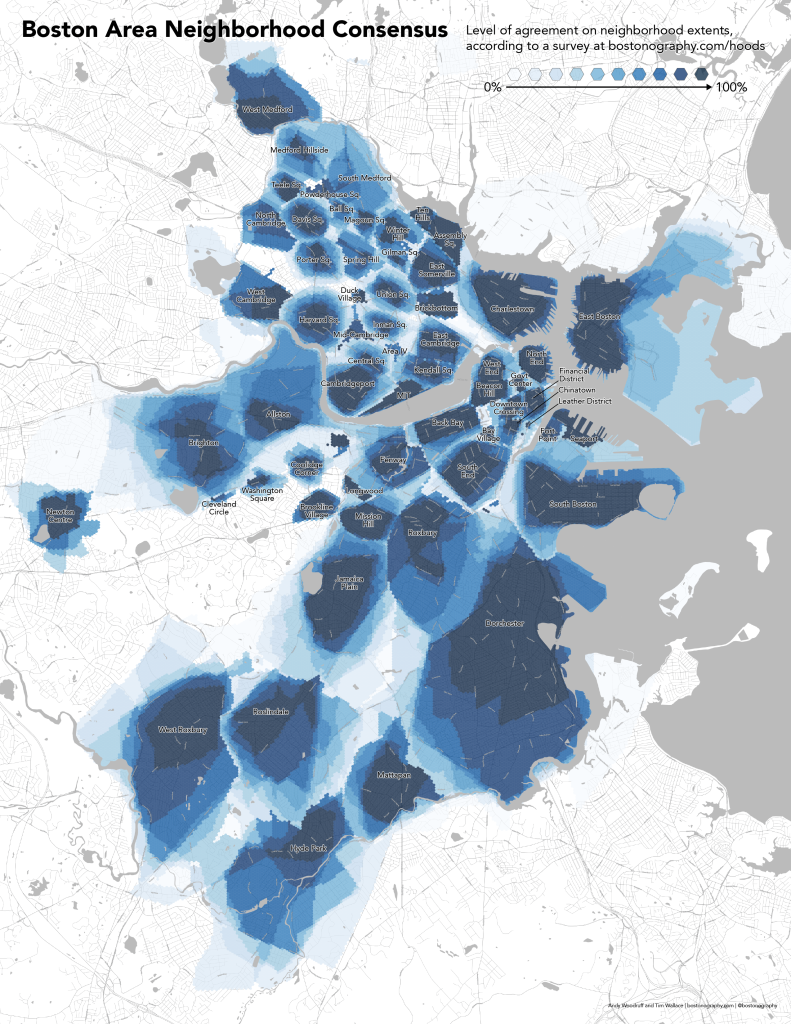
Wasn't sure where this should go, so this thread seems perfect:

Bostonography just posted an updated user-submitted neighborhood map of Boston and its urban neighbors. I love this approach because it shows where some boundaries are definite while others are hazy.

It's very interesting how (as they point out) Boston's official neighborhoods largely match what people talk about as neighborhoods, whereas in Cambridge people talk about "squares" as the heart of neighborhoods--but officially, squares are usually where multiple neighborhoods meet. Porter, Harvard, and Central are the most obvious examples.

Here's a small version - follow the link above to access the high-res version:
hoods2017_web2-01-791x1024.png
 
1. Manhattan, NY; 72,826/sq mile
2. Brooklyn, NY; 37,137
3. The Bronx, NY; 34,321
4. Queens, NY; 21,460
5. Somerville, MA; 18,868
6. San Francisco, CA; 18,451
7. Patterson, NJ; 17,346
8. Cambridge, MA; 17,130 (109,694 + 450 grad student residents)
Cambridge, MA + coll students; 26,648/sq mile (110,144 residents + 60,000 students)
9. Jersey City, NJ; 16,737
10. Boston, MA; **14,000

i had/have Somerville at #5. i wonder what the density for Boston + Cambridge + Somerville + Chelsea + Brookline is.
i should do the arithmetic for that.
 

Back
Top