General Infrastructure

The issue is that Harvard owns all the land on the north side of cambridge street too, which is right next to the HBS and science project. They don't even know what they are doing with THAT land within the next decades, so who knows how long it will take to do something with Beacon Park.

The best solution might be to force them to enter into a long term lease on the property (possibly through the threat of ED), so the land is used for SOMETHING, but should they still need the land 40, 60, 80, 100 years down the line they have the option to not renew the lease.

You can't threaten Harvard with eminent domain. Harvard is the kind of institution you use ED to transfer land TO. Frankly, I think it's pretty unlikely that Harvard believes it's ever going to develop that land - they bought it well before the realignment of the Turnpike was ever proposed, so most of it would be perpetually inaccessible. It's a pure long-term investment for them: buy it cheap when the ramps and rails are still up, and then sell it at a gargantuan profit in 50 years when all the impediments are gone. Harvard's the type of institution that can front the money for that sort of thing, and they'll make hundreds of millions of dollars if they sell it, especially since the State is covering all the costs of making the land developable.

The leverage you have with Harvard is that the success of their investment is solely dependent on you moving the highway. That was the logic I used when I proposed an Olympic Stadium there - give them the ramps in return for the use of the land until 2025, meanwhile they get to say the Olympics were held at Harvard and get all the PR off of that. I had assumed that post-games the university would develop a village of graduate/market housing at Beacon Park, which would also have the benefit of a DMU stop by 2025. They could either sell or rent it, it doesn't really matter as long as there's something there.

Alternately, Harvard could decide that this is their Kendall and try to locate a bunch of offices and hotels nearby the newly-moved-in science and engineering departments. I have a hunch that's why they moved them across the river in the first place. With the proximity to BU, it would do well.
 

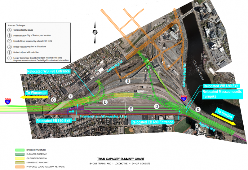
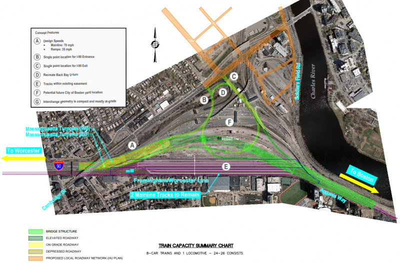
The second plan (the bottom of the Boston.com article) is much better than the first. I'm honestly not sure they could have made more of the land dead than they did with the first plan. The reason for doing so, though, is pretty transparent: that goshdarn "City of Boston Yard". Is there truly no better place that could go in the entire City of Boston? In the second plan, they actually free up all that land in the center to front Cambridge St. with a real grid, and still: "City of Boston Yard."

That said, it's still just a label on a map. I'd push hard for the bottom plan, which actually has a pretty small footprint considering how far the MBTA has pushed the highway out...

EDIT: PDF of the better plan - http://www.boston.com/yourtown/news/Allston Interchange - Alt 8F3 Modified 8-1-13.pdf
 
It would be interesting to see if they could have split exits on the Eastbound direction. One with direct access to Storro Drive and another for "local" traffic.

Plan 2 is nice because it's straighter, but the off ramp from EB is a bit odd.
 
It would be interesting to see if they could have split exits on the Eastbound direction. One with direct access to Storro Drive and another for "local" traffic.

Plan 2 is nice because it's straighter, but the off ramp from EB is a bit odd.

I've got no problem with it being odd if it takes up less room. They also seem to really be pushing this "exit right into the Harvard campus" agenda with both of these.

The only way I could see to graft a direct ramp for Storrow here is to split the EB exit ramp on the bridge section, run it alongside the opposing lanes of the highway for 1/2-mile, keep it at ground level as the rest of the highway goes up onto the viaduct, and bring it in under the ramps. It's probably pretty tough to engineer, but I think it's geometrically possible, and it keeps the envelope small.
 
Both of those plans just plain suck. The second obviously less than the first, but it still seems incredibly sloppy. Wasn't the whole point of CSX vacating because they no longer needed the yard? Not sure I understand why the City of Boston now feels like it needs one in the same location?
 
Both of those plans just plain suck. The second obviously less than the first, but it still seems incredibly sloppy. Wasn't the whole point of CSX vacating because they no longer needed the yard? Not sure I understand why the City of Boston now feels like it needs one in the same location?

The train yard is one of the candidates recommended for further study on the MBTA's commuter rail Layover Needs Assessment Report released this spring: http://www.massdot.state.ma.us/Portals/25/Docs/efs/C-LayoverFacilityAlternativesAnalysisReport.pdf.

It is not a fait accompli that they are going to need that easement because other parcels were also advanced for further study. For example, they're only using half the land space at the existing Readville CR facility. The rest is just dirt piles. And there is more space to be had at Widett Circle if they can find a relocated parcel for the city-owned BTD car impound lot and/or the private cold storage warehouse business. So the reason these prelim designs have to work around the easement is that that's 1 of 2 (the other being Readville) alternatives that the T has guaranteed control over. If they don't pick that Beacon Park easement MassDOT would be able to design a straighter Pike alignment that just leaves the 2 mainline tracks + maybe future slack space for a 3rd passing track.


Frankly, the BRA can help matters here by brokering a land swap for that cold storage business at Widett. And maybe if we're lucky even the Boston Food Market buildings sitting in the middle of Widett Circle so their southside storage needs are set for another half-century. Those businesses would probably work better at Marine Terminal co-mingled with the seafood depots. It's kind of bizarre the T would study that easement way out in the open and not study at all repurposing the crappy engine house yard parcel that's always going to be an unattractive redevelopment prospect pinned in by Storrow and ramps, but I guess that also requires Harvard land swapping with BRA help so they had to play it conservative in the report studying only the easement.


I definitely don't think they're close to settling on a final design, and public comment will be a good opportunity to make some pointed remarks. That looks like a significantly lower-capacity interchange which is going to make Cambridge St./Storrow traffic snarled even worse. That traffic has to go somewhere else, so I don't see how they can do it that way without outright project dependencies on more WB exits downtown and waiving tolls between 93 and the Allston exit to force that traffic off Storrow. Then, with the Storrow induced demand relocated, I can understand the logic of lopping off some ramp capacity with a single traffic light vs. merges. But that'll be an utter nightmare if nothing here changes the traffic loads on Storrow.
 
I've got no problem with it being odd if it takes up less room. They also seem to really be pushing this "exit right into the Harvard campus" agenda with both of these.

The only way I could see to graft a direct ramp for Storrow here is to split the EB exit ramp on the bridge section, run it alongside the opposing lanes of the highway for 1/2-mile, keep it at ground level as the rest of the highway goes up onto the viaduct, and bring it in under the ramps. It's probably pretty tough to engineer, but I think it's geometrically possible, and it keeps the envelope small.

The less space the better, however I hope they don't skimp on adding in merging lanes for those coming on the Pike. The Pike should be widened to 5, or 6 lanes if necessary to allow those coming onto the Pike to merge in safely and smoothly.

It would be ideal if the Pike widened by 2 lanes a half mile before the exit at the tolls where one lane would be for those going to Storrow and 1 for local traffic onto Cambridge street.
 
It's maddening that land-banking is allowed for more than x-years after undeveloped land is bought. Neither Harvard nor any other developer should be allowed to sit on land for decades without putting forth both a master plan and a reasonable time table. At a certain point they should have to put-up or put it on the market.

Busses -- why because you know better what should be done in 10 to 20 years than the land owner?

Consider MIT buying Simplex and miscellaneous land around Kendall / Central -- these were bought in some cases 40 or more years ago

Yet had B-nt-T's plan been effect the great economic development of Kendall now expanding to Central might have been stymied by low rise 70, 80, 90 small developments

Or consider Anthony acquiring abandoned rail yards along the South Boston water front -- took decades -- now we have one of the hottest development districts in the US
 
You can't threaten Harvard with eminent domain. Harvard is the kind of institution you use ED to transfer land TO. Frankly, I think it's pretty unlikely that Harvard believes it's ever going to develop that land - they bought it well before the realignment of the Turnpike was ever proposed, so most of it would be perpetually inaccessible. It's a pure long-term investment for them: buy it cheap when the ramps and rails are still up, and then sell it at a gargantuan profit in 50 years when all the impediments are gone. Harvard's the type of institution that can front the money for that sort of thing, and they'll make hundreds of millions of dollars if they sell it, especially since the State is covering all the costs of making the land developable.

The leverage you have with Harvard is that the success of their investment is solely dependent on you moving the highway. That was the logic I used when I proposed an Olympic Stadium there - give them the ramps in return for the use of the land until 2025, meanwhile they get to say the Olympics were held at Harvard and get all the PR off of that. I had assumed that post-games the university would develop a village of graduate/market housing at Beacon Park, which would also have the benefit of a DMU stop by 2025. They could either sell or rent it, it doesn't really matter as long as there's something there.

Alternately, Harvard could decide that this is their Kendall and try to locate a bunch of offices and hotels nearby the newly-moved-in science and engineering departments. I have a hunch that's why they moved them across the river in the first place. With the proximity to BU, it would do well.


Equilib -- Haaahvd -- can't admit outside of very very inner circle that MIT cleaned their clock -- Alston is their attempt to create a Kendall

Negatives:
1) are its a long way from Haaaahvd Sq and most of the Campus
2) Lousy transportation access so far

Positives:
1) could be right next to most of the Science at Haaahvd
2) could have its own Pike and Commuter Rail connects
3) close to Longwood Medical

Jury is still out on whether Haaaavd's Negs beat their Pos or vise versa -- or essentially Haaahvd versus MIT

What we do Know is that MIT has at least a 20 year head start over Haaahvd-- with MIT Phase I already in Business [e.g. Cambridge Center], University Park], Phase II under construction [e.g. Novartis Campus, Phizer] and Phase III in detail planning {e.g. MIT Kendall Sq Initiative]

Their problem, if the final design looks anything like this, is going to be that Cambridge St. is no Broadway in terms of how much it can be built up. The way these ramps are laid out (particularly in the first design), the land Harvard will have to build on is in deep blocks surrounded by ramps. That's condusive to office parks, but not terribly friendly to urbanized streetfronts.

Maybe the people Harvard's looking to draw won't care if they end up in basically a Burlington office park in Boston, but everyone else will. MassDOT needs to be designing this to maximize developable land, but since the State doesn't own the property except for their easement they have no incentive to design the interchange that way.

Really, this design needs 3 things: direct access to Cambridge St, direct access to/from Storrow WB/WB and EB/EB, and the largest and least blocked off amount of open land the can manage. Oh, and someone needs to actually freaking build something there.
 
Equilib -- Haaahvd -- can't admit outside of very very inner circle that MIT cleaned their clock -- Alston is their attempt to create a Kendall

Negatives:
1) are its a long way from Haaaahvd Sq and most of the Campus
2) Lousy transportation access so far

I've got to call you (and the bitchy professors) out on this first point. I walk home from the Hoyloke gate (end of the #1 bus) to near new Charlesview in about 15 minutes every day. Barrys Corner, the center of the new campus is about halfway. If that's not a walkable distance I don't know what is.

As for the second point, Harvard has planned for a subway to connect the two portions of its campus since the red line was extended. If transit is such a point of contention, they should build it themselves. They already run a fleet of buses, I see no reason why they couldn't buy a few trolleys too (or run buses through their new tunnel).
 
Ok, first image to post:

2du0.jpg


Thanks, Van!

This was done in PowerPoint because I like to keep my lines parallel, but you get the idea. It uses the same color scheme as in the MassDOT renders:

Dark green = "Elevated roadway", basically embankment
Bright green = "Bridge structure", or viaduct
Light yellow = "On-grade roadway", I only used this for highway mainline
Darker yellow = "On-grade ramp"
Orange = "Local roadway"
Blue circles = Signalized intersections

I = EB I-90 -> Cambridge St.
II = Cambridge St. -> WB I-90 (this requires the removal of Lincoln St.)
III = Cambridge St. -> EB I-90 (yes, these meet. Thus, it's a 3-phase signal, Thru/Left/Left)
IV = WB I-90 -> Cambridge St.
V = EB I-90 -> EB Storrow (mess with this and III to make sure you've got decent weaving room)
VI = WB Storrow -> WB I-90

A = "Harvard Innovation District". I am going to continue blabbing about putting the Olympics here until they officially decide not to.
B = MBTA railyard
C = That damn "City of Boston Yard"
D = Riverside parkland

The EB and WB ramps from I-90 to Cambridge St. would see a lane merge off I-90. It would immediately return as EB I-90 passes under Cambridge St and gain the lane from the EB onramp for a total of 5 EB lanes, then one would permanently spin off toward Storrow. Tolls would be placed upstream of Cambridge St.

An issue with this is that while it serves current demand, it doesn't really do much for induced demand on Storrow and could theoretically worsen it. To address this, signage would be heavy at the Cambridge St/Soldier's Field Rd. intersection with "Downtown Boston" clearly indicated as a right turn onto Cambridge St. and a protected left onto the Turnpike. The Cambridge/SFR intersection can be designed to clearly stripe and favor that turning movement (dashed-line it right into the pavement). The intersection of Storrow Drive/Soldier's Field Rd/Stadium Blvd would be designed to prioritize SFR/SD movements in the same fashion. However, the signalized intersection will make the decision between the Pike and Storrow more equal in utility to drivers approaching from the north and west.

If the MBTA extended a light rail tunnel under the Charles, a cut-and-cover could be built through the Harvard campus under pathways and the new basketball arena, surfacing in a reservation in the center of Stadium Blvd. It would then enter another tunnel (built in concert with the new Storrow), pass under the new highway embankment (built in concert with the highway) and the railyard, and join with a sunken B line at Babcock and Comm. Ave. With the investment in the river tunnel, a light rail branch could be brought to Harvard Sq. with the potential for an expensive extension to Union Sq. to complete the loop. Stations at "Harvard Square", "Harvard Stadium" (under the arena btw. Western and N. Harvard), "Beacon Park" (Cambridge and Stadium on the surface) and "BU West" (Babcock and Commonwealth).

I don't think that the roadway parts of this are terribly expensive, and it meets the important criteria: access to Cambridge St, access to Storrow, maximize buildable land.
 
Last edited:
Equilib --- Quite an impressive project on your part -- "go sell it on the mountain" [Beacon Hill] and in the Sqaaaaaah [to Haaaaaaahvd] --- who knows you might get everybody's attention

PS: how do people on foot get too/fro the existing athletic complex --- over or under all the width of the transit infrastructure?

Whigh, I was actually thinking last night about writing an email to urban planning professor(s) at Harvard/MIT and asking them to make some noise about this. I'm just a grad student, but they might be able to get some attention.

Not sure what you mean by getting to/from the athletic complex. Harvard's? The light rail would be underground. It would just mean tearing up some paths and fields temporarily for cut/cover then putting it all back. BU's? It's no different than it is now. The constraint there is actually the railyard, not the ramps or highway. Theoretically, they'd have the light rail tunnel to move them across the tracks. Maybe it could be paralleled by a ped tunnel.

EDIT: Come to think of it, that's one way to get the LRT tunnel built under the highway and railyard before you build the rest of the light rail: make it a dual-use ped/bike/LRT tunnel and open the ped/bike portion immediately. Like this: http://www.marinbike.org/Campaigns/Infrastructure/CalParkIndex.shtml
 
Equilib -- Brilliant!

I don't always fall out of balance and off the wagon -- but when I do I read Equilib!
 
Got around to playing with this today.

As a refresher, MassDOT option 1:

Mass1_zps445b9593.png


and option 2:

Mass2_zps45ac0c8b.png


Then here's what I came up with:

BeaconPark_zps4be2f1c4.png


Obviously I'm building off my old idea of having the Pike interchange with Soldiers Field Road, using it as a distributor. The two main things I concentrated on were 1) maximizing developable land and 2) maximizing parkland along the Charles. I did also attempt to design an adequate highway, however.

Key points:
-SFR has been moved to the other side of Genzyme/Double Tree to free up as much land along the Charles as possible. It is in an open cut, 80' wide so possible to be decked over.
-The SB entrance for SFR is on the north side of Cambridge St to allow as much room for weaving and merging before the interchange as possible.
-NB Exit for SFR (hence also the Pike and Storrow) lands on a distributor road with access to both Cambridge St and Western Ave.
-Direct onramp to the WB Pike accessable from both Cambridge St and Commonwealth (via an extended Malvern Street). Both are right turns.
-Travel from Soldiers Field Road onto Storrow Drive and back again is permitted. However you can not go from the Pike onto Storrow, only north onto SFR. Basically to discourage using Storrow and encourage using the Pike.
-Viaduct is demolished in favor of a cut, with the commuter rail on top. In retrospect Storrow could be moved on top as well to free up more parkland, I just didn't show it that way.
 
Trying to parse the functional differences between Davems and Equilibrias diagrams.

Equib - If you eliminate SFR through the area, where does Storrow pick up again? At the University exit, or down at Chatlesgate?
 
Davem,

I like your plan way, way better than the two officially proposed interchanges, which I consider to be land wasting suburban type layouts not suitable for a high density urban development area.

Your plan links Soldiers Field Road (SFR) directly with the Pike, which is important because SFR and Fresh Pond Parkway are the major traffic link to the Alewife area and Route 2 to Arlington, Lexington and points west. Also your layout lends itself to the eventual closing of Storrow Drive, or at least the downgrading of it to a minor surface boulevard.

The one thing I would modify is the curviness of the Pike at the proposed interchange. The proposed on/off ramps could be closer to the Pike's through lanes with use of retaining walls, allowing the Pike through lanes to be less curvy.
 
Trying to parse the functional differences between Davems and Equilibrias diagrams.

Equib - If you eliminate SFR through the area, where does Storrow pick up again? At the University exit, or down at Chatlesgate?

Presumably, if you blow up SFR, Storrow has been downgraded or eliminated as well.
 

Back
Top