General Infrastructure

This is very much on the radar of the local Allston community.

I believe it. I want MassDOT to have to tell us what's wrong with Dave's plan. They'll find things, but hopefully they'll also change their parameters a bit.
 
BeaconPark-Pike_zpsb12f5fc7.png

But how do I get to Cambridge? You've got a horrible right-left to get to the River Street Bridge. I think that exit could merge with Cambridge St Cambridge-bound and curl around on the other side to merge with Cambridge St. Allston-bound without sacrificing too much land.
 
I believe it. I want MassDOT to have to tell us what's wrong with Dave's plan. They'll find things, but hopefully they'll also change their parameters a bit.

Somebody cross-post that on the Somethingawful.com thread where the ConnDOT traffic engineer answers forum questions. That guy gave a 5-minute stab at redesigning the interchange last year with his pro software (and he...literally...designs interchanges for a living). Unfortunately SA no longer lets you view the forums without a personal login so I can't find that particular post.
 
But how do I get to Cambridge? You've got a horrible right-left to get to the River Street Bridge. I think that exit could merge with Cambridge St Cambridge-bound and curl around on the other side to merge with Cambridge St. Allston-bound without sacrificing too much land.

Its a simple four way signilized intersection, timed to favor traffic exiting the pike. Remember the entire point of me doing this was to free up room for development and create a pedestrian Cambridge St. Having anything merge with Cambridge St is the opposite of that. The exit also really can't peel off before Cambridge St to be on the south side due to insuffecent weaving room.

Remember though, this intersection and the road in front of Genzyme as proposed won't be nearly the hellhole they are today. I've moved almost all the loads elsewhere, the only cars going through that intersection will be those taking River St to get to Central and Cambridgeport, as well as a small portion taking the Pleasant St extension along the river, which is a two lane road.
-Traffic for Harvard Square and north will stay on SFR and cross at the great bridge.
-Traffic coming from either Western Ave or Cambridge St have dedicated onramps of their own instead of both cramming up that intersection and fighting cramming up that onramp by the Double Tree.
-All traffic getting off the Pike to get on SFR/Storrow now do so in the interchange, instead of jamming up Cambridge St.

I think I made that road in front of Genzyme 52' wide, so 4 11' travel lanes + 1 parking lane. Striped north of the offramp as two NB lanes and two SB lanes, while south of the offramp one NB lane, one SB left turn line, one SB left turn+ straight lane, and one right turn lane. The Pleasant St extension would have a probition of left turns onto cambridge, further reducing conflicts (they would turn prior to the double tree).
 
^ I dunno man. I think you are grossly underestimating the traffic flowing up River street and on up Prospect. You think its just Central and Cambridgeport? That is the way to Inman, Kendall and East Cambridge, Union and East Somerville. People don't drive 5 miles out of the way through downtown and up 93 to get to Somerville. They take exit 18. Your SFR connection takes Harvard, Porter, and Davis bound cars off of River and relocates them to Harvard Square. There are about a million people who would fight to keep lower Allston undeveloped for a lifetime rather than add more cars to Harvard Square.
 
^ I dunno man. I think you are grossly underestimating the traffic flowing up River street and on up Prospect. You think its just Central and Cambridgeport? That is the way to Inman, Kendall and East Cambridge, Union and East Somerville. People don't drive 5 miles out of the way through downtown and up 93 to get to Somerville. They take exit 18. Your SFR connection takes Harvard, Porter, and Davis bound cars off of River and relocates them to Harvard Square. There are about a million people who would fight to keep lower Allston undeveloped for a lifetime rather than add more cars to Harvard Square.

Tony, that sounds more like a concern about Storrow access than about the Cambridge St. portion of the plan. I'm with you on the Storrow part, but Dave's included direct, stoplight-less access to Storrow EB from the Turnpike. It's off to the right-hand side of the diagram.

The only cars making that right/left movement will be going to Harvard Square and Cambridgeport, and maybe MIT and Central. The Somerville, Kendall, etc. traffic will continue to use Storrow, and that connection is easier on Dave's plan.

EDIT: Ok, I think I see what you're saying. Dave, could one of those on-ramps near Genzyme become an off-ramp from SFR into Cambridge? There's no connection between SFR and Cambridge St. as you've drawn it here. They would, in fact, have to use either Mem Drive or Harvard Square.
 
Dave, could one of those on-ramps near Genzyme become an off-ramp from SFR into Cambridge? There's no connection between SFR and Cambridge St. as you've drawn it here. They would, in fact, have to use either Mem Drive or Harvard Square.

Wow, I can't believe I missed the lack of a SB exit on SFR. This is why extra sets of eyes are great. Fixed without loosing the dual SB entrances from both Cambridge St and Western ave. The two orange N/S streets would likely have to be made a one way pair to handle the volume getting on/off SFR here, but that shouldn't be too much of an issue. They are both 42' wide, for two 7' parking lanes, two 11' travel lanes, and one 6' bike lane.
BeaconPark1029_1_zps3551a5dd.png


As for traffic heading up River St, this is the configuration of the intersection as I see it. Remember Cambridge St is not going to be seeing nearly the traffic it does today. I can't see this not being able to handle the traffic.
Exit18B_zps2c2ab211.png


Here are some closeups, see if there are any other issues.

I-90 to SFR interchange:
BeaconPark-90toSFR_zps17b71169.png


I-90 to Storrow Drive interchange:
BeaconPark-90toStorrow_zps5e8190c6.png


SFR exits:
BeaconPark-SFRexit_zps07305681.png
 
Very much like this plan. How do you plan to get the new leg of the wye to the Grand Junction? Seems like it'd cross the Pike at the same level.
 
could you address the problem that the lots are divided by the highway in such a way as they would be impossible to develop? If it is redone it should not be redone in such a way as to hinder development on some of the land. you could probably fix this pretty easily.

They would be developed by decking SFR (not exactly a highway, though in this plan it looks an awful lot like one). Really only the lot closest to the wye requires any buildings over the road, so it should be much simpler than the Turnpike, say. In the other cases, it's just a corner. They can cantilever the entrance plaza off the overpass (and design the overpasses for it) or from their building itself and be done. Minimal loads.
 
Very much like this plan. How do you plan to get the new leg of the wye to the Grand Junction? Seems like it'd cross the Pike at the same level.

The GJ goes underneath the Viaduct right now and threads between the girders before it spits out on the Storrow side. The junction with the Worcester Line would either be underneath, or start a little further west. Nothing fundamental would change about how the GJ tracks are currently laid out under there. That change takes place the second the main yard tracks are torn out, so you're talking like 9-18 months for the track reconfiguration to happen. It'll way precede this project by a good 5+ years.

There isn't enough room there behind West Campus to cram every single thing side-by-side, and overhead RR viaduct is klunky with how much weight it has to support and aligning the GJ split off it with the elevation of the Charles crossing (which is going to be many feet lower than the over-Pike tracks) is klunkier with how fast it would have to descend from 16 ft. elevation over the highway to 10 ft. elevation over the water with only 450 ft. or so of horizontal running space. That's steep for RR grades, especially going downhill onto a river crossing. So leaving the eastern third of the Viaduct as-is is a necessity. It's just not going to wash from an engineering standpoint to trade levels trains vs. highway.

You won't be able to connect Agganis Way to the street grid because of this, but everything else here is doable. You could thread one of those cross streets intersecting Babcock Ext. over/under the ramps to connect to the river road and offer some grid redundancy for those lots in lieu of Agganis Ext. Nothing else gets fundamentally compromised. You just have to concede that the eastern third of viaduct from the Nickerson Field property line to Comm Ave. has to be permanent. No practical way around it, and fussing with that surplus-to-requirement eats all the cash you could put to better use on the Storrow/SFR interface.


If it weren't for the GJ slicing diagonally underneath and being impossible to change in elevation I would even think that little Pike maintenance slip ramp on the WB side by Comm Ave. could be upgraded into your real-deal offramp tucked neatly away out-of-view under the viaduct. Or stuff Storrow EB under there, move WB onto the EB carriageway, and turn the WB carriageway into a little extra Esplanade space. Unfortunately Urban Ring is beyond the timetable for this highway project so track layout underneath isn't changeable. That might be something to consider 10 years in when the UR changes it to more easily dip-under- able LRT or BRT, so a little wiggle room for future enhancement under the east third of the as-is viaduct might be good to keep in-pocket.
 
Last edited:
I followed MassDOTs color scheme, so brown is a cut. So basically the Pike begins decending below grade between Carlton St and Comm Ave. The tracks stay at roughly the same elevation the whole way they are now, +/- maybe four feet. I would envision the WB Pike a full 16' below grade to accomidate tracks above, with the EB lanes 6' where its right next to the Charles, and 16' where the tracks need to cross. The shallow EB cut could be decked over for expansion of parkland in the future.

Keeping the Pike below grade allows the freedom to have the tracks cross pretty much anywhere, hence a new leg off the Grand Junction towards South Station. I'm not as concerned about the structure to support them as F-line is. Supporting a peak load of a 12 lane traffic jam in the wind on a viaduct is huge compared to three trains. I left 12' or so between the EB and WB Pike mainlines, so the structure to the support the tracks only needs to span the WB portion. A viaduct for trains is inherently far less complex then for automobiles. It does not require drainage, lighting, or a pavement deck. Salt erosion isn't an issue. Maintence also seems to be better, look how long the Grand Junction held itself together with terrible maintance vs the other river crossings.

The other bonus of getting the Pike below grade is the cross streets only need to get up over the tracks, so they can start decending while still over the Pike. That's how I was able to pull off getting Franklin St and Agganis Way over. The new dorm at the end of Agganis Way also has an exposed basement, so the surrounding grade could be raised to be flush with the top of the new bridge (a lot of the west campus is like that, so in theory the railroad could be decked over by BU). IIRC railroad clearances are a bit less too, 14'?, so its less for the bridge to climb.
 
Unfortunately Urban Ring is beyond the timetable for this highway project so track layout underneath isn't changeable. That might be something to consider 10 years in when the UR changes it to more easily dip-under- able LRT or BRT, so a little wiggle room for future enhancement under the east third of the as-is viaduct might be good to keep in-pocket.

F-Line, I'd been thinking that having this big a site aimed directly at Harvard campus and the end of the Harvard/Brattle tunnel is a great opportunity to predig some tunnels and line up infrastructure for Green Line service at least as far as Harvard Square. Obviously, the river crossing isn't in the cards with this project, nor is the necessary tunneling of the B-Line to Packard's, but it's easier and cheaper to get things ready as a part of this project for the time when the time comes for the rest. Harvard's pushed quite hard for light rail under their Allston campus, after all.

What do you think?
 
I followed MassDOTs color scheme, so brown is a cut. So basically the Pike begins decending below grade between Carlton St and Comm Ave. The tracks stay at roughly the same elevation the whole way they are now, +/- maybe four feet. I would envision the WB Pike a full 16' below grade to accomidate tracks above, with the EB lanes 6' where its right next to the Charles, and 16' where the tracks need to cross. The shallow EB cut could be decked over for expansion of parkland in the future.

Keeping the Pike below grade allows the freedom to have the tracks cross pretty much anywhere, hence a new leg off the Grand Junction towards South Station. I'm not as concerned about the structure to support them as F-line is. Supporting a peak load of a 12 lane traffic jam in the wind on a viaduct is huge compared to three trains. I left 12' or so between the EB and WB Pike mainlines, so the structure to the support the tracks only needs to span the WB portion. A viaduct for trains is inherently far less complex then for automobiles. It does not require drainage, lighting, or a pavement deck. Salt erosion isn't an issue. Maintence also seems to be better, look how long the Grand Junction held itself together with terrible maintance vs the other river crossings.

The other bonus of getting the Pike below grade is the cross streets only need to get up over the tracks, so they can start decending while still over the Pike. That's how I was able to pull off getting Franklin St and Agganis Way over. The new dorm at the end of Agganis Way also has an exposed basement, so the surrounding grade could be raised to be flush with the top of the new bridge (a lot of the west campus is like that, so in theory the railroad could be decked over by BU). IIRC railroad clearances are a bit less too, 14'?, so its less for the bridge to climb.

You may still have issues with the GJ's elevation over the highway being different from the bridge's elevation over the water, and having only a few hundred feet of running space on a curve to change elevations. So there's some figures that would have to be verified here:

-- Depth of the cut. Is this a true below-ground cut at air rights depth or or a half-cut just to lower the highway's profile? How deep is this going while still being able to be waterproofed from a Charles flood. This is important!...the BU Sailing Pavilion area on the Esplanade goes underwater like once every other year when the Charles floods its banks. You have to build this for annual, 5-year, decade, 20-year, AND 50-year flood events on that particularly susceptible and silt-mushy stretch of riverbank.
-- Depth of the cut minus height of the rail-over-highway. 16 ft. minimum overhead clearance is the interstate highway standard for new construction. You can probably do that here without need for taller clearance because any overheight traffic here that can't fit in the Back Bay tunnel has already exited.
-- Height of the GJ river crossing. Don't know what it is, but it's slightly shorter than that 11 ft. truck-eating Storrow overpass.
-- Exact amount of running space between where the rail viaduct splits and the river bridge (or 11 ft. Storrow bridge if that stays).


Known-knowns:
-- 1% is the ideal grade for RR elevation changes. 100 ft. of running space for every 1 ft. change in elevation.
-- 2.2% is the FRA max before special waivers come into play.
-- No waivers will be allowed for a junction onto a wye onto a water crossing above a highway all in the span of like 500 ft. Have to be *very* conservative here, hanging as close to that 1% recommendation as possible. Maybe even less because you're on a sharp wye curve.
-- You can't change the elevation of the water crossing at all or the tracks will no longer fit under Memorial Drive. It's already height-restricted for freight, and Mem Dr. was already raised once on that large 'hump' to make it all work.


Now...looks like on the renderings there's about 450 ft. of space between where the tracks split off the viaduct and where it meets the bridge. Do your best calculations there on change of height. If it starts getting kludgy trying to make it all fit...that's a sign that you're fighting a losing engineering battle.

Note: If it's too tight you have 1 solve that'll work for sure with no disruption...ditching the tight wye leg from the SS end and dragging the other leg further west to give it more running room for elevation changes after it splits off. You lose the ability to do a North Station-South Station shuttle, keep the ability to do everything the line currently does + everything they were studying with it (Worcester-North Station, Amtrak-North Station, etc.). I wouldn't hold the NS-SS straight shot too near-and-dear if it comes to this. That's going to be a slow-ass trip pulling a U-turn there and the GJ can't support a full DMU's schedule with the grade crossings, so that potential isn't as high as it looks. If it saves the rest of your design to whack that leg of the wye and make the elevation changes work...do it and don't think twice.


EDIT: On second thought, I think the floods are gonna be a bigger problem with the depressed highway than anything else. I remember from my BU days how soggy that Sailing Pavilion area routinely got. And how that whole span of Esplanade was impassible for weeks after the Flood of '96. There be big problems if there isn't a really really good drainage solution with that depressed road.
 
Last edited:
Some assumptions I've made.
-The Pike is ~20' below grade where it crosses under Comm Ave by the BU Bridge.
-The Pike and tracks are level with the tracks at this point.
-The Grand Junction Bridge is approximately level with the tracks.
-IIRC Interstate standards allow for a 6% grade.

So if the Pike starts heading down at Carlton St, its got ~600' of room before to dive another 16-20' to get under the tracks,a roughly 3% grade. So we're good here, the tracks don't have to change in elevation at all, providing the GJ and B&A are approximately level with each other.

As soon as the EB Pike clears the Grand Junction it would start rising again as to not run too deep near the Charles. Flooding could be an issue here, even with waterproofing some pumps would likely be necessary. Worries about the Charles topping its banks and outright flooding the cut could be addressed by decking it. The grade of the esplanade could also be raised a few feet for further protection too, which would also make decking easier.

In a nutshell, the Pike would need to dive down as deep as needed to allow the railroad to stay within the 1% elevation clearance (maybe push it to 1.33%). What that depth is I don't know without a real topographic map, right now I'm going off google earth and streetview signage for clearance restrictions. But it would be no more than 20', likely a few feet less.

A viaduct would be easier no doubt, however it would be worse from an urban perspective (doesn't allow for decking with buildings and parkland), and also makes a South Station leg of a GJ wye impossible. For those two reasons I will be working with a cut as the "preferred alternative", but a viaduct is possible with only a few changes.
 
F-Line, I'd been thinking that having this big a site aimed directly at Harvard campus and the end of the Harvard/Brattle tunnel is a great opportunity to predig some tunnels and line up infrastructure for Green Line service at least as far as Harvard Square. Obviously, the river crossing isn't in the cards with this project, nor is the necessary tunneling of the B-Line to Packard's, but it's easier and cheaper to get things ready as a part of this project for the time when the time comes for the rest. Harvard's pushed quite hard for light rail under their Allston campus, after all.

What do you think?

There's not much to line up. The walking path between the JFK School buildings is on perfect alignment with the portal to the abandoned Red Line tunnel, and in turn tees up one of a few shot under the river that can land on one side of the Stadium or the other without messing up athletic facilities. It's a delicate dig for sure between the building foundations, but Harvard hedged 30 years ago when it built the site that something like that could possibly be needed in the next half-century, and they better space the buildings so it's at least possible to attempt a build without nuking the buildings to the ground. If they're ready they study, they get the engineering assessment on the feasibility, they make a go/no-go. But there's zero reason to pre-prep a tunnel for something that may or may not happen in 25 years, and which they already anticipated might happen.

You also don't want to touch that area UNTIL the engineering assessment says it won't wreck the buildings. Because backup plan #1 if that gets a little hairy is just dumping the trolleys to loop in the bus tunnel. We know that'll work since it used to be a triple-mode tunnel: trolleys, trackless trolleys, and diesel buses all at once. And there's no reason the initial build has to include a river crossing. If it's sufficiently grade-separated through Allston a little bit of street-running on JFK and Eliot St. into the bus tunnel works just spiffy for the first 20 years.


As for the Pike, it depends on how much things get changed. If there's still an easterly-third of the Viaduct you can tuck the LRV's under there, dip under the Grand Junction when it crosses, and work over to Cambridge St. in the middle of ramp-land. For example, the current Cambridge St. setup has that freight siding under the bridge next to the ramp. Depending on how you intersect Cambridge St. a similar little provision under a similar bridge can preserve a grab-and-go ROW. It's not hard to traverse that land with trolleys that can climb steep grades and dip quickly underneath things. Look how steep the Science Park incline is at getting under the Leverett Circle ramps. And that's a constrained space...this is a gigantic bare canvas. So don't think pre-pouring tunnels now...think setting aside a little 20 ft. of slack space off to the side on a ramp underpass like that freight siding and keeping some logical straight way (preserved viaduct or replacement for the viaduct) of getting from BU Bridge to ramp-land when it's time.

Crossing Allston and making it to the foot of the JFK St. bridge on grade separation is trivial and fully under Harvard's land control. Street-running it across the bridge into the bus tunnel is trivial and works as the 25-year starter solution. Hooking it to the Green Line is trivial...you just bury the B to BU Bridge and use BU Academy and the grassy knoll between the Pike/Storrow/BU Bridge for a station + flying junction + Urban Ring portal + swingback on-alignment for a new B portal. There's no engineering magic with a reservation dig. And thus no need to be pre-pouring unused tunnels.

Just don't seal all manner of escape through ramp-land. And hopefully they won't because the Harvard spur was an official part of the Urban Ring Phase II BRT and Phase III rail and has reams of study data MassDOT hasn't erased from memory and Harvard won't let them erase from memory. Ask about it in a community meeting and they'll probably have a prepared answer that the design won't preclude a busway with partial-or-better grade separation. And if it doesn't prevent a busway, it won't prevent light rail.
 
Some assumptions I've made.
-The Pike is ~20' below grade where it crosses under Comm Ave by the BU Bridge.
-The Pike and tracks are level with the tracks at this point.
-The Grand Junction Bridge is approximately level with the tracks.
-IIRC Interstate standards allow for a 6% grade.

So if the Pike starts heading down at Carlton St, its got ~600' of room before to dive another 16-20' to get under the tracks,a roughly 3% grade. So we're good here, the tracks don't have to change in elevation at all, providing the GJ and B&A are approximately level with each other.

As soon as the EB Pike clears the Grand Junction it would start rising again as to not run too deep near the Charles. Flooding could be an issue here, even with waterproofing some pumps would likely be necessary. Worries about the Charles topping its banks and outright flooding the cut could be addressed by decking it. The grade of the esplanade could also be raised a few feet for further protection too, which would also make decking easier.

In a nutshell, the Pike would need to dive down as deep as needed to allow the railroad to stay within the 1% elevation clearance (maybe push it to 1.33%). What that depth is I don't know without a real topographic map, right now I'm going off google earth and streetview signage for clearance restrictions. But it would be no more than 20', likely a few feet less.

A viaduct would be easier no doubt, however it would be worse from an urban perspective (doesn't allow for decking with buildings and parkland), and also makes a South Station leg of a GJ wye impossible. For those two reasons I will be working with a cut as the "preferred alternative", but a viaduct is possible with only a few changes.

GJ and B&A aren't level with each other today: http://goo.gl/maps/kozA1. They split level, then stay level while the GJ threads through the viaduct pilings. Then when it reaches the Storrow side of the viaduct it starts an 800 ft. run up an incline on a slight curve to reach the 11' high truck-eating Storrow bridge. Keeping in mind that Storrow sits about 2-3 ft. below the tracks when it starts this incline (Turnpike Authority did think about flood protection...the MDC, not so much). So that is textbook example of a near-exact 1% grade that you can follow for its whole length right on Google Street View. That might be a helpful comparison if trying to visualize what these kinds of calculations would translate to in real life concrete.
 
Without more information I don't know if that new leg is possible depending on how big the difference is between the GJ and the B&A. Thatbeingsaid even without the wye there is a third yard track coming off the GJ for reversing moves, and it could always be run around the wye to get into the yard.

Different topic, the development around SFR. Equilibria basically hit it on the head, either the buildings would canteliever over where there is a corner or bridge across SFR where it's in the center. I have SFR at only 80' wide with generous room on each side, which is comparatively easier to span a building across than the Pike downtown. Also keep in mind, Harvard will be developing the majority of this, and their pockets go deeper when it comes to aesthetics on campus, so they are more likely to pay for decking.

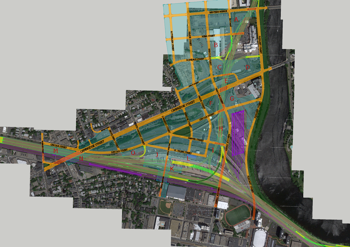
New map with developable parcels in teal, and labels on the ones that interact with the highways.
Parcels_1.png


I left Genzyme a generous amount of land and air rights to play with for parking/future expansion.
-Parcel A: Bridged along Cambridge St, on solid land everywhere else. Belongs to Genzyme, so nothing might happen.
-Parcel B: Solid land.
-Parcels C,D&E: Bridged over SFR, solid land otherwise
-Parcels F&G: Cantilever over the SFR in the corner.
-Parcel H: Bridged along Sawyer and Lincoln Streets, solid land along Babcock and Hague, exposed in the center.
-Parcels I: Bridged over narrow ramps, otherwise solid land.
-Parcel J: Half easily buildable solid land, half over ramps with generous room for supports between them.
-Parcel K: This is pushing it, but the ramps is narrow so it might be worth it to build a very deep apartment building.
-Parcels L: Solid land, easy.
-Parcels M&N: Very difficult to build over, but would be amazing to tie together the two sides of Allston. Some incentives to private developers could make something happen.
Parcel O: I drew it as a small section on solid land, but it could extend over the Pike. $$$

Babcock Street has some potential for decking on its eastern side, but it would be on par with the downtown parcels. It would also be difficult to develop along Malvern Street, however it should be strongly encouraged to knit together the two neighborhoods.
 
MassDot is building ground parking lots under the I-93 overpass, will create a new public space, extend the harbor walk and connect the south bay harbor trail to Kneeland street:http://blog.mass.gov/transportation...eks-interest-parking-availability-under-i-93/

MassDOT intends to develop the multi-use parking facility with activity, light and security 24/7/365, serving different customers throughout peak commuting hours, off-peak weekday hours, and weekends.

Phase 1 of the project scheduled for substantial completion in December 2013 includes construction of 235 parking spaces accessible from Albany Street, improved pedestrian conditions, increased lighting, and other improvements to the site.

Phase 2 scheduled for substantial completion in December of 2014 will include construction of approximately 192 parking spaces accessible from Traveler Street, a new multi-modal path connecting the South Bay Harbor Trail to Kneeland Street, and a new, transportation-themed public space which extends the Boston Harborwalk along the Fort Point Channel.
 
What is a transportation-themed public space - a parking lot? A parking park?

"Yo dawg, I heard you like parking lots, so I put a parking park next to your parking lot so you can park when you park."

xzibit-happy.jpg
 
What is a transportation-themed public space - a parking lot? A parking park?

"Yo dawg, I heard you like parking lots, so I put a parking park next to your parking lot so you can park when you park."

xzibit-happy.jpg

Greenspace. Sure...the grass will probably die from lack of sunlight, but that's what artificial turf was made for!

Hizzoner said:
If all you snitches hadn't been so against the Casey Overpass so my personal driver can get me to work without traffic lights, you all could have tons of greenspace to play on underneath the overpass.

Now behave yourselves this week in the parade for Ortiz splitting the uprights, you hear me!
 

Back
Top