Gov't Center Station Rebuild

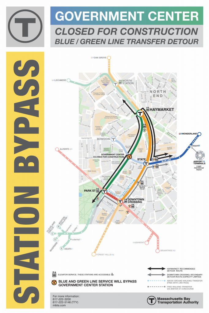
So they've put more detour route signs in the stations including at State St - OL Forest Hills platform - Washington/Milk exit right in front of the exits in the middle of the unpaid lobby. Tourists have been stopping to stare dumbfounded at the sign while holding up the entire flow of people on and off trains.
 
RABBLE RABBLE RABBLE.

It's amazing what you can build in a vacuum. Nevermind what you can build in one of the countries oldest cities. Fuck these kids.

Do you attribute the sluggish pace of MBTA projects to the age of the city primarily?
 
What do you guys think about the official MBTA detour map? I found it ok, but I can read maps well and am a transit geek. On the other hand, my friends on Facebook have found it extremely confusing and numerous people have posted about it. I submitted the map to Cameron Booth's Transit Maps Tumblr for his thoughts and ideas.

http://www.mbta.com/uploadedfiles/Riding_the_T/RecommendedPathOfTravel.pdf

RecommendedPathOfTravel_zps9ce5e099.png
 
Last edited:
That's not Jarrett Walker, that's Cameron Booth's website.
 
I like the giant in-your-face banner on top of the headhouse noting the closure. Printing off a score of these would be a good way to advertise the start of late-night service, which I haven't seen much about other than online.
 
I LOVE the gradient they used on the government center text. The map itself is a bit confusing, however. Boy am I glad I didn't move to eastie now!
 
I LOVE the gradient they used on the government center text. The map itself is a bit confusing, however. Boy am I glad I didn't move to eastie now!

Funny you mention that. I've actually been on the apartment search lately, and have looked at a coupld in Eastie. However I travel out of South Station to NYC pretty frequently, and often need the red line for other things during the week. I could really use the Red/Blue Connector, because to go from blue, down one stop to red, down one stop to get my bus to NYC is just too much shuffling around. Now with eh government center station closed, it's enough to make me second guess living over there.

It's too bad, the state street stop is almost right next to my office.
 
Cameron gave a very thoughtful and thorough response: http://transitmaps.tumblr.com/post/80198563319/boston-govt-center

tl;dr:
Cameron Booth said:
It’s actually kind of frightening that two paragraphs of text on the MBTA website can do a better job of explaining the bypass than this map can — a visual medium should really be able to explain this so much more clearly than a text-based or verbal solution ever could.

Also, he mixed up my name. =P
 
Among all the other things wrong with the detour map - it also fails to show that walking from bowdoin to haymarket on new sudbury st, or from state to haymarket on congress st, are also attractive options for connections between the GL and the BL

I wonder if any of our resident 'crazy transit pitch designers' would be interested in redirecting their considerable talents to a better version of this?
 
oh and also the unexplained suggestion of a continuous SL loop of the airport terminals is somewhere between hillarious pathetic and ingenious
 
Among all the other things wrong with the detour map - it also fails to show that walking from bowdoin to haymarket on new sudbury st, or from state to haymarket on congress st, are also attractive options for connections between the GL and the BL

I wonder if any of our resident 'crazy transit pitch designers' would be interested in redirecting their considerable talents to a better version of this?

I think the T is afraid to market the fact that Bowdoin is open for all service hours now. The station really cannot handle many people and would reach crush capacity if they advertised it as an "official route." State really can't handle it either, but it can handle the load better than Bowdoin. Bowdoin will just have to be a secret for locals to use during these 2 years of misery.
 
^Good one, you just added 6 months to the construction schedule for new signage.
 
I would recommend editing/deleting that post. Numerous industry officials and professionals monitor this board. You have just admitted guilt to a felony and are likely on camera doing it.
 
Last edited:
For those of you criticizing, it had "demo" spray painted in blue on it. If anything I sped up the construction schedule. And no, I am not a terrible person.
 
Will the D and B lines be going to Haymarket? Or will I have to do a 3rd transfer at Park if I want to go to the D or B lines from the Blue Line? That sign doesn't make it very clear.
 
Will the D and B lines be going to Haymarket? Or will I have to do a 3rd transfer at Park if I want to go to the D or B? That sign doesn't make it very clear.

B trains go to Park Street always.

D trains go to Park Street during rush hour and North Station at other times.
 
People left goodbye messages on the walls last night:
http://www.flickr.com/photos/elmercat/tags/scollay/

gcdawg.jpg


I also took one final ride through GC last night. Apparently the T had some cops on the GL platform standing there all day screaming "TAKE YOUR PICTURES NOW! GOVERNMENT CENTER IS CLOSING FOR TWO YEARS TONIGHT! TAKE YOUR PICTURES!"
 
Here's the Globe's take on illustrating the route disruptions:

Odd that neither the Blue nor Red lines are traced in grey rather than blue or red. It would have also been useful if they gave the frequency of the shuttle and indicated the direction it takes in making this circuit. Otherwise, the sentence explaning the Green to Blue connection is very clear.
 

Back
Top